
Wassertrüdingen
| coat of arms | Germany map | |
|---|---|---|

|
Coordinates: 49 ° 2 ' N , 10 ° 36' E |
|
| Basic data | ||
| State : | Bavaria | |
| Administrative region : | Middle Franconia | |
| County : | Ansbach | |
| Height : | 423 m above sea level NHN | |
| Area : | 53.58 km 2 | |
| Residents: | 6053 (Dec. 31, 2019) | |
| Population density : | 113 inhabitants per km 2 | |
| Postal code : | 91717 | |
| Primaries : | 09832, 09836 | |
| License plate : | AN , DKB, FEU, ROT | |
| Community key : | 09 5 71 214 | |
| City structure: | 17 parts of the community | |
City administration address : |
Marktstrasse 9 91717 Wassertrüdingen |
|
| Website : | ||
| Mayor : | Stefan Ultsch ( SPD ) | |
| Location of the city of Wassertrüdingen in the district of Ansbach | ||
  |
||


Wassertrüdingen is a town in the district of Ansbach in Middle Franconia ( Bavaria ).
geography
Geographical location
The former margrave town of Wassertrüdingen is above 420 m above sea level. NN on the Wörnitz approaching from the west in a wide valley , which takes up the Lentersheimer Mühlbach from the north and then bends to the south. In a west-north-westerly direction, this extends from the city over more than seven kilometers, up to 689 m above sea level. NN high small massif of the Hesselberg , a Jura- Zeugenberg and the only mountain in Franconia that offers a view of the Alps . The Franconian Lake District begins around 15 kilometers to the northeast near Gunzenhausen . The Hahnenkamm ends in the east . To the southwest of Wassertrüdingen are the vast forest heights of the Oettinger Forest .
The city lies on the German holiday route between the Alps and the Baltic Sea .
City structure

The municipality has 17 officially named municipal parts (the type of settlement is given in brackets ):
|
|
|
There are seven districts (as of November 1, 2019) :
| District | Residents (only main residence) |
|---|---|
| Wassertrüdingen | 4442 |
| Altentrüdingen with Eislerhof | 203 |
| Fürnheim with Goschenhof and Himmerstall | 365 |
| Geilsheim with Oberaumühle | 538 |
| Obermögersheim with Laufenbürg | 551 |
| Reichenbach with steel yards | 65 |
| Sliding roof | 153 |
In the municipal area were the deserted Buchhof , Forsthöfe and Schafhof , all of which have now been demolished .
Neighboring communities
Neighboring municipalities are starting from the north and working clockwise:
climate
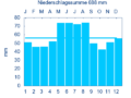
Diagram of precipitation mean values Wassertrüdingen for the period from 1961 to 1990


The average amount of precipitation in Wassertrüdingen is 688 mm per year.
history
Until the church is planted

Wassertrüdingen was built as a moated castle in the High Middle Ages . In contrast to Altentrüdingen, the ancestral seat of the noble free von Truhendingen ( Altentrüdingen Castle ) and their later Hohentrüdingen Castle , this new establishment on the Wörnitz was given the name Wassertrüdingen . As the builders of the castle, the castle men of the lords of Truhendingen are called the "Fricken von Wassertrüdingen". As early as 1242, the Lords of Truhendingen ceded the castle to the Counts of Oettingen, who were enfeoffed with it by Bishop Philipp von Eichstätt. This is also the first written mention of the place. A settlement that was first mentioned in 1242 developed rapidly under the influence of the Counts of Oettingen. As early as 1366, Count Ludwig Junior von Oettingen sold the town, palace and castle Wassertrüdingen to Georg von Hohenlohe. In disputes with the Lords of Oettigen, Georg's brother, Gerlach von Hohenlohe, finally sold the castle and town of Wassertrüdingen together with Altentrüdingen to the Burgraves of Nuremberg in 1371 . The Burggräfliche Amt Wassertrüdingen became the margravial Oberamt Wassertrüdingen as its legal successor in the 15th century . As part of Ansbach, the city belonged to the Franconian Imperial Circle formed in 1500 . The Reformation was introduced in 1528 .
In 1623 three women were accused as alleged witches in Wassertrüdingen during the witch hunt, two of whom were executed (Helena Kuch, Apollonia Güttinger) and one was expelled from the country (Barbel Förßnerin). On August 24, 1634, troops from the Electorate of Cologne under Johann von Werth plundered the city during the Thirty Years' War . After the great war, the city and its surroundings became a refuge for numerous religious refugees from Austria who had been expelled as a result of the Counter Reformation and who were involved in the reconstruction. The Napoleonic Wars brought the city, due to troop movements and billeting, expenses and war debts.
Wassertrüdingen was in the Fraisch district of the Ansbach Oberamt Wassertrüdingen . The city regiment was exercised by the mayor and councilor Wassertrüdingen . By the end of the 18th century there were 345 properties. The following Ansbach offices were the landlords :
- Kastenamt Wassertrüdingen (1 town mill, 1 fulling mill , 1 brickworks, 1 estate with bleach, 8 inns with brewing rights, 99 houses, 1 two-thirds house, 194 half houses, 1 third house, 27 quarter houses , 8 drip houses )
- Poor Foundation Wassertrüdingen (1 poor and infirmary)
- Auhausen administrator's office (2 half houses).
In addition to these properties, there was a castle, a vestibule with a bailiff's apartment, a deanery, a chaplain’s house, a parish church, a chapel, a synagogue, a town hall, a school house, a shepherd’s house, two gatehouses, a crushing house and a shooting house. From 1797 to 1808 the place was subordinate to the Justice and Chamber Office Wassertrüdingen .
In 1806 Wassertrüdingen came to the Kingdom of Bavaria . As a result of the municipal edict , the Wassertrüdingen tax district was formed in 1809 , to which the towns of Altentrüdingen , Baudenhart , Fallhaus , Stockaumühle and Walkmühle belonged. At the same time, the municipality of Wassertrüdingen was created, to which Baudenhart and Walkmühle belonged. In administration and jurisdiction it was subordinate to the Wassertrüdingen Regional Court and the Wassertrüdingen Rent Office ( renamed Wassertrüdingen Tax Office in 1919 , Gunzenhausen Tax Office 1932–1973 , Ansbach Tax Office from 1973 ). The jurisdiction remained with the district court Wassertrüdingen until 1879, from 1879 to 1956 the district court Wassertrüdingen was responsible, from 1956 to 1970 the district court Gunzenhausen and from 1970 to 1973 the district court Dinkelsbühl , which has been a branch of the district court Ansbach since 1973 . The administration was taken over by the newly created Dinkelsbühl district office in 1862 (renamed the Dinkelsbühl district in 1938 ). With the dissolution of the Dinkelsbühl district in 1972, Wassertrüdingen came to the Ansbach district. In 1961 the municipality had an area of 8.763 km².
Incorporations
| Former parish |
Residents (1970) |
date |
|---|---|---|
| Altentrüdingen | 237 | July 1, 1971 |
| Fürnheim | 262 | May 1, 1978 |
| Geilsheim | 653 | May 1, 1978 |
| Obermögersheim | 545 | July 1, 1972 |
| Reichenbach | 89 | July 1, 1971 |
| Sliding roof | 158 | July 1, 1971 |
Population development
In the period from 1988 to 2018, the population increased from 5574 to 6041 by 467 inhabitants or 8.4%.
Wassertrüdingen community
| year | 1818 | 1840 | 1852 | 1861 | 1867 | 1871 | 1875 | 1880 | 1885 | 1890 | 1895 | 1900 | 1905 | 1910 | 1919 | 1925 | 1933 | 1939 | 1946 | 1950 | 1961 | 1970 | 1987 | 1995 | 2005 | 2016 |
|---|---|---|---|---|---|---|---|---|---|---|---|---|---|---|---|---|---|---|---|---|---|---|---|---|---|---|
| Residents | 1769 | 1948 | 1828 | 1746 | 1763 | 1734 | 1694 | 1773 | 1767 | 1797 | 1772 | 1776 | 1806 | 1910 | 1870 | 1775 | 1736 | 1666 | 2618 | 2989 | 3024 | 3434 | 5600 | 6326 | 6138 | 6023 |
| Houses | 388 | 261 | 261 | 270 | 311 | 350 | 350 | 494 | 1347 | 1616 | ||||||||||||||||
| source |
Location Wassertrüdingen
| year | 1818 | 1840 | 1861 | 1871 | 1885 | 1900 | 1925 | 1950 | 1961 | 1970 | 1987 |
|---|---|---|---|---|---|---|---|---|---|---|---|
| Residents | 1760 | 1933 | 1720 | 1721 | 1757 | 1769 | 1763 | 2974 | 3014 | 3425 * | 3722 |
| Houses | 386 | 258 | 268 | 309 | 348 | 347 | 491 | 847 | |||
| source |
politics

City council
The city council consists of 20 members. After the municipal council elections in 2002, 2008 and 2014 , he sat down equally, as follows:
Since the CSU citizen list split off in 2016, the distribution has been:
- CSU: 7 seats
- CSU citizen list: 6 seats
- SPD: 5 seats
- Municipal forum 96: 2 seats
Since the reunification at the end of 2018 the distribution is:
- CSU: 13 seats
- SPD: 5 seats
- Municipal forum 96: 2 seats
mayor
In November 2018, Stefan Ultsch (SPD) was elected the new mayor of the city of Wassertrüdingen with 66.75% of the vote. The CSU candidate Rainer Breit lost to him with 33.25%. The turnout was 62.30%. The predecessor since 2008 was Günther Babel (CSU).
badges and flags
|
|
Blazon : “ Quartered ; 1 and 4: a four-legged golden chest in red with a desk lid and lock plate, 2 and 3: again quartered, 2 of black and silver, 3 of silver and black "
Black and white municipal flag |
| Justification of the coat of arms: The coat of arms is first handed down in the imprint of a seal from 1387. The chests speak for the place name, which is actually derived from the personal name Truhtmund. The crossing of silver and black is the so-called Zollernvierung . Since 1371 the Franconian Hohenzollern (Burgraviate Nuremberg, Brandenburg-Ansbach) ruled over Wassertrüdingen. |
Town twinning
Since 1982 there has been a partnership with the municipality of Bellac in the French region of Nouvelle-Aquitaine .
Culture and sights
Buildings
On the Hesselberg there is a Deutsche Telekom transmission tower designed as a hybrid tower with a steel lattice tower as the substructure.
The Evangelical Lutheran City Church of the Holy Trinity stands in the city center . It was built between 1738 and 1740 by Leopoldo Retti as the third residential church in the margrave style. The choir goes back to the previous Gothic church. Inside there is a valuable winged altar from around 1500 with motifs from the Christmas story. In the tower of the town church, a renovated is Türmer apartment.
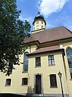
Evangelical City Church Holy Trinity
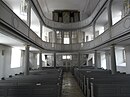
City church from the inside
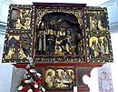
Altar of the city church

Rectory at Kirchgasse 4

Upper gate at Marktstrasse 3
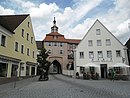
The Spalter Bierstube at the city gate

Catholic
Holy Spirit Church
Catholic Walburga Church

Town mill
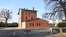
Former railway station


Architectural monuments
Museums
- Fisheries and Natural History Museum
- Türmerstube
- Beekeeping Museum
- Fluvius Museum
Regular events
- Wassertrüdinger Volksfest
- "Trüdinger Nussmärtel Drift" (on November 10th)
- International motorcycle meeting on the Hesselberg (MRC Wassertrüdingen) (on the last full weekend in June)
- Old Town Festival (on the first weekend in July)
- Midsummer bonfire of the Protestant rural youth
- Africa-Caribbean Festival
- Tough Mudder (Southern Germany)
State horticultural show

In 2019 Wassertrüdingen hosted the Small State Horticultural Show in Wassertrüdingen from May 24th to September 8th .
traffic

Since 1849 there has been a train station in Wassertrüdingen on the Nördlingen – Gunzenhausen section of the former Ludwig-Süd-Nord-Bahn , which was the first important railway line in Bavaria to connect Lindau with Hof . The section of the route is now operated as a museum railway for passenger traffic, and freight traffic has been taking place again for some time now, and is operated by BayernBahn .
The state road 2221 leads north to Unterschwaningen over after Großenried or south to Auhausen . The state road 2218 leads west to Gerolfingen or east to Geilsheim . The state road 2248 goes north to Lentersheim . The State Road 2219 connects the St 2218 with the St 2221 as a bypass road. Municipal roads lead to Schobdach and Opfenried .
Personalities
sons and daughters of the town
- Michael Samhammer (1602–1676), cloth maker in Wassertrüdingen during the Thirty Years' War
- Johann David Steingruber (1702–1787), margravial builder ("agricultural inspector")
- Julius Conrad von Yelin (1771–1826), physicist, mathematician and tax officer
- Christian Friedrich Freyer (1794–1885), one of the renowned entomologists of the 19th century
- Otto von Beust (1799–1864), Royal Bavarian Major General
- Georg Caspar Mezger (1801–1874), pedagogue and librarian, director of the Protestant Annagymnasium in Augsburg
- August von Voit (1801–1870), architect
- Albert Hauck (1845–1918), Protestant theologian
- Christian Gruber (1858–1906), teacher and geographer
- Hans Kohn (1866–1935), physician and discoverer of Kohn's alveolar pores
- Ulrich Enzensberger (* 1944), German writer
- Werner Färber (* 1957), German children's book author
- Johannes Seidlitz (* 1990), German racing car driver
People connected to the city
- Siegfried von Truhendingen (1146–1150), Bishop of Würzburg
literature
- Johann Kaspar Bundschuh : Wassertrüdingen . In: Geographical Statistical-Topographical Lexicon of Franconia . tape 6 : V-Z . Verlag der Stettinische Buchhandlung, Ulm 1804, DNB 790364328 , OCLC 833753116 , Sp. 110-111 ( digitized version ).
- August Gebeßler : City and district of Dinkelsbühl (= Bavarian art monuments . Volume 15 ). Deutscher Kunstverlag, Munich 1962, DNB 451450930 , p. 209-218 .
- Georg Muck: History of Heilsbronn Monastery from prehistoric times to modern times . tape 2 . For Kunstreprod. Schmidt, Neustadt an der Aisch 1993, ISBN 3-923006-90-X , p. 521-522 (first edition: Beck, Nördlingen 1879).
- Teresa Neumeyer: Dinkelsbühl: the former district (= Historical Atlas of Bavaria, part of Franconia . I, 40). Michael Laßleben, Kallmünz 2018, ISBN 978-3-7696-6562-8 , p. 399 f .
- Wolf-Armin von Reitzenstein : Lexicon of Franconian place names. Origin and meaning . Upper Franconia, Middle Franconia, Lower Franconia. CH Beck, Munich 2009, ISBN 978-3-406-59131-0 , p. 234-235 .
- Gottfried Stieber: Wassertrüdingen . In: Historical and topographical news from the Principality of Brandenburg-Onolzbach . Johann Jacob Enderes, Schwabach 1761, p. 906-917 ( digitized version ).
- Pleikard Joseph Stumpf : Wassertrüdingen . In: Bavaria: a geographical-statistical-historical handbook of the kingdom; for the Bavarian people . Second part. Munich 1853, p. 766-767 ( digitized version ).
Web links
- Map of the city of Wassertrüdingen on the BayernAtlas
- City of Wassertrüdingen - Official website
- Wassertrüdingen in the Topographia Franconiae of the University of Würzburg , accessed on September 17, 2019.
- Wassertrüdingen: Official statistics of the LfStat
Individual evidence
- ↑ "Data 2" sheet, Statistical Report A1200C 202041 Population of the municipalities, districts and administrative districts 1st quarter 2020 (population based on the 2011 census) ( help ).
- ^ Community Wassertrüdingen in the local database of the Bavarian State Library Online . Bayerische Staatsbibliothek, accessed on September 17, 2019. There 18 parts of the municipality, as the Schafhof, which was demolished in the 1980s, is listed as part of the municipality.
- ↑ Prehistory of the city and the former principality of Ansbach, p. 119.
- ↑ W.-A. v. Reitzenstein, p. 234. For the meaning of the place name, see Altentrüdingen .
- ↑ Prehistory of the city and the former principality of Ansbach, p. 119.
- ^ Gerhard Beck: "All sorts of traps" from the church registers of Auhausen an der Wörnitz. In: Leaflets of the Bavarian State Association for Family Studies . tape 76 . Self-published, 2013, ISSN 0005-7118 , p. 57 .
- ↑ Eberhard Krauss: Exulanten im Evang.-Luth. Deanery Wassertrüdingen (= sources and research on Franconian family history . No. 28 ). GFF, Nuremberg 2014, ISBN 978-3-929865-61-5 .
- ^ T. Neumeyer, p. 471.
- ^ Johann Bernhard Fischer : Wassertrüdingen . In: Statistical and topographical description of the Burggraftum Nürnberg, below the mountain, or the Principality of Brandenburg-Anspach. Second part. Containing the economic, statistical and moral condition of these countries according to the fifteen upper offices . Benedict Friedrich Haueisen, Ansbach 1790, p. 385 ( digitized version ). According to this, there were 195 houses (half, third or quarter houses were probably not taken into account).
- ↑ According to JK Bundschuh, Vol. 6, Col. 110, there were 222 houses (half, third or quarter houses were probably not taken into account).
- ↑ a b T. Neumeyer, p. 582.
- ^ T. Neumeyer, p. 534.
- ^ Address and statistical manual for the Rezatkreis in the Kingdom of Baiern . Buchdruckerei Chancellery, Ansbach 1820, p. 72 ( digitized version ).
- ↑ a b c Bavarian State Statistical Office (ed.): Official city directory for Bavaria, territorial status on October 1, 1964 with statistical information from the 1961 census . Issue 260 of the articles on Bavaria's statistics. Munich 1964, DNB 453660959 , Section II, Sp. 764-765 ( digitized version ).
- ↑ a b c d Wilhelm Volkert (Ed.): Handbook of the Bavarian offices, communities and courts 1799–1980 . CH Beck, Munich 1983, ISBN 3-406-09669-7 , p. 448 .
- ↑ a b Federal Statistical Office (ed.): Historical municipality register for the Federal Republic of Germany. Name, border and key number changes in municipalities, counties and administrative districts from May 27, 1970 to December 31, 1982 . W. Kohlhammer, Stuttgart / Mainz 1983, ISBN 3-17-003263-1 , p. 707 f .
- ↑ a b Only inhabited houses are given. In 1818 these were designated as fireplaces , in 1840 as houses , and from 1871 to 2016 as residential buildings.
- ↑ a b Alphabetical index of all the localities contained in the Rezatkreise according to its constitution by the newest organization: with indication of a. the tax districts, b. Judicial Districts, c. Rent offices in which they are located, then several other statistical notes . Ansbach 1818, p. 100 ( digitized version ). For the municipality of Wassertrüdingen plus the residents and buildings of Baudenhart (p. 8) and Walkmühle (p. 99).
- ^ A b Eduard Vetter (Ed.): Statistical handbook and address book of Middle Franconia in the Kingdom of Bavaria . Self-published, Ansbach 1846, p. 249-250 ( digitized version ). According to the historical municipality register , the municipality had 1924 inhabitants.
- ^ A b c d e f g h i Bavarian State Statistical Office (Hrsg.): Historical municipality directory: The population of the municipalities of Bavaria from 1840 to 1952 (= contributions to Statistics Bavaria . Issue 192). Munich 1954, DNB 451478568 , p. 168 , urn : nbn: de: bvb: 12-bsb00066439-3 ( digitized ).
- ↑ a b Joseph Heyberger, Chr. Schmitt, v. Wachter: Topographical-statistical manual of the Kingdom of Bavaria with an alphabetical local dictionary . In: K. Bayer. Statistical Bureau (Ed.): Bavaria. Regional and folklore of the Kingdom of Bavaria . tape 5 . Literary and artistic establishment of the JG Cotta'schen Buchhandlung, Munich 1867, Sp. 1006 , urn : nbn: de: bvb: 12-bsb10374496-4 ( digitized version ).
- ↑ Kgl. Statistisches Bureau (Ed.): Directory of the municipalities of the Kingdom of Bavaria according to the status of the population in December 1867 . XXI. Issue of the contributions to the statistics of the Kingdom of Bavaria. Ackermann, Munich 1869, p. 157 ( digitized version ).
- ↑ a b Kgl. Statistical Bureau (ed.): Complete list of localities of the Kingdom of Bavaria. According to districts, administrative districts, court districts and municipalities, including parish, school and post office affiliation ... with an alphabetical general register containing the population according to the results of the census of December 1, 1875 . Adolf Ackermann, Munich 1877, 2nd section (population figures from 1871, cattle figures from 1873), Sp. 1172 , urn : nbn: de: bvb: 12-bsb00052489-4 ( digitized version ).
- ↑ K. Bayer. Statistical Bureau (ed.): Community directory for the Kingdom of Bavaria. Manufactured due to the new organization of government districts, district offices and judicial districts. Addendum to issue 36 of the articles on Bavaria's statistics. Munich 1879, p. 61 ( digitized version ).
- ↑ K. Bayer. Statistical Bureau (ed.): Community directory for the Kingdom of Bavaria. Results of the census of December 1, 1880. Issue 35 of the articles on Bavaria's statistics. Munich 1882, p. 176 ( digitized version ).
- ↑ a b K. Bayer. Statistical Bureau (Ed.): Localities directory of the Kingdom of Bavaria. According to government districts, administrative districts, ... then with an alphabetical register of locations, including the property and the responsible administrative district for each location. LIV. Issue of the contributions to the statistics of the Kingdom of Bavaria. Munich 1888, Section III, Sp. 1104 ( digitized version ).
- ↑ a b K. Bayer. Statistical Bureau (Ed.): Directory of localities of the Kingdom of Bavaria, with alphabetical register of places . LXV. Issue of the contributions to the statistics of the Kingdom of Bavaria. Munich 1904, Section II, Sp. 1170 ( digitized version ).
- ↑ a b Bavarian State Statistical Office (ed.): Localities directory for the Free State of Bavaria according to the census of June 16, 1925 and the territorial status of January 1, 1928 . Issue 109 of the articles on Bavaria's statistics. Munich 1928, Section II, Sp. 1208 ( digitized version ).
- ↑ a b Bavarian State Statistical Office (ed.): Official place directory for Bavaria - edited on the basis of the census of September 13, 1950 . Issue 169 of the articles on Bavaria's statistics. Munich 1952, DNB 453660975 , Section II, Sp. 1040 ( digitized version ).
- ↑ a b Bavarian State Statistical Office (Hrsg.): Official local directory for Bavaria . Issue 335 of the articles on Bavaria's statistics. Munich 1973, DNB 740801384 , p. 172 ( digitized version ).
- ↑ a b Bavarian State Office for Statistics and Data Processing (Ed.): Official local directory for Bavaria, territorial status: May 25, 1987 . Issue 450 of the articles on Bavaria's statistics. Munich November 1991, DNB 94240937X , p. 331 ( digitized version ).
- ↑ Wassertrüdingen: Official statistics of the LfStat
- ↑ Entry on Wassertrüdingen's coat of arms in the database of the House of Bavarian History
- ↑ Wassertrüdingen. In: Kommunalflaggen.eu. Retrieved July 14, 2020 .
- ↑ wassertruedingen.de
- ↑ webmuseen.de
- ↑ Gartenschau Wassertrüdingen 2019. Accessed on November 23, 2017 .
- ↑ bayerisches-eisenbahnmuseum.de
- ^ Friedrich Löhrl: History of the city of Wassertrüdingen. Wassertrüdingen 1926.

Adelshofen | Arberg | Aurach | Bechhofen | Bruckberg | Book at the forest | Burgoberbach | Burk | Colmberg | Dentlein am Forst | Diebach | Dietenhofen | Dinkelsbühl | Dombühl | Dürrwangen | Ehingen | Feuchtwangen | Flachslanden | Gebsattel | Gerolfingen | Geslau | Heilsbronn | Herrieden | Insingen | Langfurth | Lehrberg | Leutershausen | Lichtenau | Merkendorf | Mitteleschenbach | Mönchsroth | Neuendettelsau | Neusitz | Oberdachstetten | Ohrbach | Ornbau | Petersaurach | Röckingen | Rothenburg ob der Tauber | Rügland | Saxony near Ansbach | Schillingsfürst | Schnelldorf | Schopfloch | Steinsfeld | Unterschwaningen | Wassertrüdingen | Weidenbach | Weihenzell | Weiltingen | Wettringen | Wieseth | Wilburgstetten | Windelsbach | Windsbach | Wittelshofen | Wolframs-Eschenbach | Wörnitz
Unregulated areas:
Lower Forest