Ornbau
| coat of arms | Germany map | |
|---|---|---|

|
Coordinates: 49 ° 11 ' N , 10 ° 39' E |
|
| Basic data | ||
| State : | Bavaria | |
| Administrative region : | Middle Franconia | |
| County : | Ansbach | |
| Management Community : | Triesdorf | |
| Height : | 419 m above sea level NHN | |
| Area : | 15.16 km 2 | |
| Residents: | 1619 (Dec. 31, 2019) | |
| Population density : | 107 inhabitants per km 2 | |
| Postal code : | 91737 | |
| Area code : | 09826 | |
| License plate : | AN , DKB, FEU, ROT | |
| Community key : | 09 5 71 189 | |
| LOCODE : | DE 2OB | |
| City structure: | 6 districts | |
City administration address : |
Vorstadt 1 91737 Ornbau |
|
| Website : | ||
| Mayor : | Marco Meier ( CSU / Voting Group Eintracht) | |
| Location of the town of Ornbau in the Ansbach district | ||
Ornbau is a town in the Central Franconian district of Ansbach and a member of the Triesdorf administrative community based in Weidenbach .
geography
Geographical location
Ornbau is located on the Altmühl , on the edge of the Franconian Lake District , 60 km southwest of Nuremberg .
Neighboring communities
The following municipalities border Ornbau (clockwise from the north):
Community structure
The political municipality Ornbau has six officially named districts :
|
The Stadtmühle residential area is part of the Ornbau district.
history
Until the church is planted
Ornbau was first mentioned in a document in 838. The name changed over the centuries from "Arenburen" (1057/75) to the current name, which has been in use since 1800. The basic word of the place name is the old high German word "būr" (= apartment) and the defining word is the personal name "Aro". The place name means the apartment that was founded by Aro .
Ornbau formed its own bailiwick around 1300 (market rights since 1229) . The place consisted of a walled and an unprotected settlement (today's suburb). Ornbau formed its own officiatus, also called minister, with its surroundings. Income from customs and courts flowed to the bishop of Eichstätt . Because of the attacks by the Counts of Oettingen , the area around Ornbau was awarded to the Prince-Bishop in 1313 . At that time, the emperor allowed Ornbau to be fortified, i.e. to be surrounded by a wall. This gave the settlement the character of a civitas , a city with municipal rights . From 1500 the city was part of the Franconian Empire .
During the witch hunt in the Hochstift Eichstätt at least three women from Ornbau were executed for alleged witchcraft. In 1616 Anna Demertin, alias the nose cutter and Apollonia Veitin, and in 1617 Christina Magin. Five other women were arrested for the same reason between 1616 and 1619. One of them was released, the fate of the others is unclear.
During the Thirty Years' War during the Swedish military campaign from Donauwörth to Regensburg under the command of Bernhard von Sachsen-Weimar near Ornbau, a battle with the cavalry troops of the Bavarian general Johann von Werth took place, in which the Bavarian troops suffered a severe defeat ( battle for Regensburg ) .
With the municipal edict (early 19th century), the Ornbau tax district was formed, to which the towns of Gern , Haag , Obermühl , Oberndorf and Taugenroth belonged. A little later the rural community Ornbau was formed, which only consisted of the main town. It was subject to the Herrieden district court in terms of administration and jurisdiction . In 1961 the municipality had an area of 8,953 km².
Incorporations
On January 1, 1972, the previously independent municipality of Gern was incorporated.
Population development
In the period from 1988 to 2018, the population increased from 1480 to 1626 or by 9.9%.
Ornbau municipality
| year | 1987 | 2005 | 2010 | 2011 | 2012 | 2013 | 2014 | 2015 | 2016 |
|---|---|---|---|---|---|---|---|---|---|
| Residents | 1457 | 1686 | 1608 | 1585 | 1584 | 1591 | 1609 | 1638 | 1646 |
| Houses | 362 | 535 | 536 | 537 | 538 | 541 | 541 | ||
| source |
Ornbau parish (= Ornbau parish until the regional reform)
| year | 1818 | 1840 | 1852 | 1855 | 1861 | 1867 | 1871 | 1875 | 1880 | 1885 | 1890 | 1895 | 1900 | 1905 | 1910 | 1919 | 1925 | 1933 | 1939 | 1946 | 1950 | 1952 | 1961 | 1970 | 1987 |
|---|---|---|---|---|---|---|---|---|---|---|---|---|---|---|---|---|---|---|---|---|---|---|---|---|---|
| Residents | 737 | 771 | 745 | 773 | 798 | 828 | 803 | 781 | 809 | 790 | 781 | 800 | 771 | 785 | 761 | 797 | 783 | 849 | 833 | 1047 | 1082 | 1042 | 982 | 1042 | 1113 |
| Houses | 200 | 156 | 157 | 159 | 156 | 158 | 181 | 202 | 289 | ||||||||||||||||
| source |
politics
City council
Ornbau's city council consists of twelve elected members and the full-time mayor.
In the local elections on March 15, 2020, the CSU / Independent Voters list received 7 seats and the Eintracht voter group 5 seats.
mayor
Mayor was Heinz Baum (CSU / Eintracht) from 2008 to 2020. His predecessor was Gerhard Helmsorig.
In the mayoral election on March 15, 2020, 27-year-old Marco Meier (CSU / Independent Voters list) prevailed against Thomas Blaumeier (Eintracht voter group) with 58.3 percent of the vote.
badges and flags
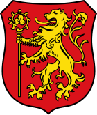
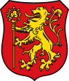
Ornbau has had its own coat of arms since the 14th century.
|
Blazon : "In red a golden lion holding an upright golden bishop's staff with its front paws turned away."
Red and gold municipal flag |
|
| Reasons for the coat of arms: The lion is one of the three lions from the English royal coat of arms, which in the late Middle Ages was believed to be the coat of arms of St. Willibald, the first bishop of Eichstätt. It was run by the Eichstätt cathedral chapter. The staff is taken from the coat of arms of the Hochstift von Eichstätt. Before 1671 the shield was split (left bishop's staff, right lion). |
Culture and sights
Architectural monuments
- Altmühlbrücke
- city wall
- Theft
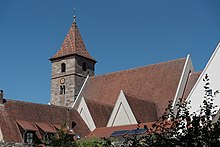
- St. James Church
- Cemetery church
- Bièvre monument in the Ornbauer cemetery: Georg Franz Maréchal Marquis de Bièvre is buried in Ornbau. He has written comedies and puns and was called in by the Margrave of Ansbach in Triesdorf for court entertainment. In 1789 he succumbed to smallpox and, because he was Catholic, could not be buried in Triesdorf. His youthful lover Anna Pas de Vassal had the monument erected in 1817.
Regular events
- Mardi Gras parade (last Sunday in Mardi Gras)
- Old town festival and Jakobi parish fair (penultimate weekend in July)
- Whitsun meeting of the Association of Tailfin Friends (old Mercedes drivers) based in Ornbau
education
Six teachers taught 66 children in the Ornbau primary school in the 2013/14 school year. The school is housed in a baroque building in the old town, built in 1764 according to plans by Maurizio Pedetti and renovated in 1988/89 . The next secondary school is in neighboring Bechhofen.
leisure
Ornbau has a river swimming pool on the Altmühl in the Gern part of the municipality . This is also where the Altmühl feeder begins, which feeds the Altmühl water to the Altmühlsee during floods .
Many cycling and hiking trails lead through Ornbau or have their start or finish point here. In the Wiesengrund, which lies in the east (the Wiesmet ), a bird sanctuary extends to Muhr am See, in which endangered bird species live.
traffic
The state road 2411 runs west of Ornbau and goes north to Willow Creek and south to Arberg . The district road AN 55 leads to Mörsach or Oberndorf , the district road AN 59 to Hirschlach . A community road leads to Gern .
Personalities
Honorary citizen
- Franz Heger (1902 - unknown)
- Bishop Lorenz Unfried (1970)
- Mayor Franz Nefzger (1972)
- Pastor Josef Fremmer (1974)
- Josef Bengel (1987)
- Pastor a. D. Franz Starringer (2012)
sons and daughters of the town
- Lorenz Unfried (1919–1988), Catholic clergyman, Bishop of Tarma in Peru
- Franz Xaver von Zottmann (1826–1901), Catholic clergyman, Bishop of Tiraspol
People associated with Ornbau
- Josef Alois Kessler (1862–1933), Archbishop, is buried in Ornbau
literature
- Johann Kaspar Bundschuh : Ear construction . In: Geographical Statistical-Topographical Lexicon of Franconia . tape 4 : Ni-R . Verlag der Stettinische Buchhandlung, Ulm 1801, DNB 790364301 , OCLC 833753101 , Sp. 265-271 ( digitized version ).
- Georg Muck: History of Heilsbronn Monastery from prehistoric times to modern times . tape 2 . For Kunstreprod. Schmidt, Neustadt an der Aisch 1993, ISBN 3-923006-90-X , p. 471–473 (first edition: Beck, Nördlingen 1879).
- Hans Karlmann Ramisch: District Feuchtwangen (= Bavarian art monuments . Volume 21 ). Deutscher Kunstverlag, Munich 1964, DNB 453909426 , p. 100-108 .
- Wolf-Armin von Reitzenstein : Lexicon of Franconian place names. Origin and meaning . Upper Franconia, Middle Franconia, Lower Franconia. CH Beck, Munich 2009, ISBN 978-3-406-59131-0 , p. 173-174 .
- Pleikard Joseph Stumpf : Ornbau . In: Bavaria: a geographical-statistical-historical handbook of the kingdom; for the Bavarian people . Second part. Munich 1853, p. 731 ( digitized version ).
Web links
- Map of the city of Ornbau on the BayernAtlas
- Ornbau in the Topographia Franconiae of the University of Würzburg , accessed on September 17, 2019.
- Ornbau: Official statistics of the LfStat
Individual evidence
- ↑ "Data 2" sheet, Statistical Report A1200C 202041 Population of the municipalities, districts and administrative districts 1st quarter 2020 (population based on the 2011 census) ( help ).
- ^ Community Wolferstadt in the local database of the Bayerische Landesbibliothek Online . Bayerische Staatsbibliothek, accessed on September 17, 2019.
- ↑ W.-A. v. Reitzenstein, p. 173 f. First mentioned after Reitzenstein in 1057/75.
- ↑ Stürzl, On the persecution of witches in the upper pen of the Hochstift Eichstätt. Addendum to: Executions for witchcraft in Eichstätt. In: Leaflets of the Bavarian State Association for Family Studies. Self-published, Munich. 2016 p. 130 ff.
- ^ Address and statistical manual for the Rezatkreis in the Kingdom of Baiern . Buchdruckerei Chancellery, Ansbach 1820, p. 46 ( digitized version ).
- ↑ a b Bavarian State Statistical Office (ed.): Official city directory for Bavaria, territorial status on October 1, 1964 with statistical information from the 1961 census . Issue 260 of the articles on Bavaria's statistics. Munich 1964, DNB 453660959 , Section II, Sp. 777 ( digitized version ).
- ^ Wilhelm Volkert (ed.): Handbook of Bavarian offices, communities and courts 1799–1980 . CH Beck, Munich 1983, ISBN 3-406-09669-7 , p. 461 .
- ↑ a b Bavarian State Office for Statistics and Data Processing (Ed.): Official local directory for Bavaria, territorial status: May 25, 1987 . Issue 450 of the articles on Bavaria's statistics. Munich November 1991, DNB 94240937X , p. 330 ( digitized version ).
- ↑ a b c d e f g h Ornbau: Official statistics of the LfStat
- ↑ Only inhabited houses are given. In 1818 these were designated as fireplaces , in 1840 as houses and from 1871 to 1987 as residential buildings.
- ↑ Alphabetical index of all the localities contained in the Rezatkkreis according to its constitution by the newest organization: with indication of a. the tax districts, b. Judicial Districts, c. Rent offices in which they are located, then several other statistical notes . Ansbach 1818, p. 70 ( digitized version ).
- ↑ Eduard Vetter (Ed.): Statistical handbook and address book of Middle Franconia in the Kingdom of Bavaria . Self-published, Ansbach 1846, p. 160-161 ( digitized version ). Ornbau: 760 inhabitants, 155 houses; Stadtmühle: 11 E., 1 H.
- ↑ a b c d e f g h i j k Bavarian State Statistical Office (Hrsg.): Historical municipality directory: The population of the municipalities of Bavaria from 1840 to 1952 (= contributions to Statistics Bavaria . Issue 192). Munich 1954, DNB 451478568 , p. 171 , urn : nbn: de: bvb: 12-bsb00066439-3 ( digitized ).
- ^ Joseph Heyberger, Chr. Schmitt, v. Wachter: Topographical-statistical manual of the Kingdom of Bavaria with an alphabetical local dictionary . In: K. Bayer. Statistical Bureau (Ed.): Bavaria. Regional and folklore of the Kingdom of Bavaria . tape 5 . Literary and artistic establishment of the JG Cotta'schen Buchhandlung, Munich 1867, Sp. 1025 , urn : nbn: de: bvb: 12-bsb10374496-4 ( digitized version ).
- ↑ Kgl. Statistisches Bureau (Ed.): Directory of the municipalities of the Kingdom of Bavaria according to the status of the population in December 1867 . XXI. Issue of the contributions to the statistics of the Kingdom of Bavaria. Ackermann, Munich 1869, p. 161 ( digitized version ).
- ↑ Kgl. Statistical Bureau (ed.): Complete list of localities of the Kingdom of Bavaria. According to districts, administrative districts, court districts and municipalities, including parish, school and post office affiliation ... with an alphabetical general register containing the population according to the results of the census of December 1, 1875 . Adolf Ackermann, Munich 1877, 2nd section (population figures from 1871, cattle figures from 1873), Sp. 1190 , urn : nbn: de: bvb: 12-bsb00052489-4 ( digitized ). Ornbau: 790 inhabitants; City mill: 13 E.
- ↑ K. Bayer. Statistical Bureau (ed.): Community directory for the Kingdom of Bavaria. Manufactured due to the new organization of government districts, district offices and judicial districts. Addendum to issue 36 of the articles on Bavaria's statistics. Munich 1879, p. 63 ( digitized version ).
- ↑ K. Bayer. Statistical Bureau (ed.): Community directory for the Kingdom of Bavaria. Results of the census of December 1, 1880. Issue 35 of the articles on Bavaria's statistics. Munich 1882, p. 181 ( digitized version ).
- ↑ K. Bayer. Statistical Bureau (Ed.): Localities directory of the Kingdom of Bavaria. According to government districts, administrative districts, ... then with an alphabetical register of locations, including the property and the responsible administrative district for each location. LIV. Issue of the contributions to the statistics of the Kingdom of Bavaria. Munich 1888, Section III, Sp. 1122 ( digitized version ).
- ↑ K. Bayer. Statistical Bureau (Ed.): Directory of localities of the Kingdom of Bavaria, with alphabetical register of places . LXV. Issue of the contributions to the statistics of the Kingdom of Bavaria. Munich 1904, Section II, Sp. 1189 ( digitized version ).
- ↑ Bavarian State Statistical Office (ed.): Localities directory for the Free State of Bavaria according to the census of June 16, 1925 and the territorial status of January 1, 1928 . Issue 109 of the articles on Bavaria's statistics. Munich 1928, Section II, Sp. 1227 ( digitized version ).
- ↑ Bavarian State Statistical Office (ed.): Official place directory for Bavaria - edited on the basis of the census of September 13, 1950 . Issue 169 of the articles on Bavaria's statistics. Munich 1952, DNB 453660975 , Section II, Sp. 1058 ( digitized version ).
- ^ Bavarian State Statistical Office (ed.): Official place directory for Bavaria . Issue 335 of the articles on Bavaria's statistics. Munich 1973, DNB 740801384 , p. 171 ( digitized version ).
- ^ Entry on the coat of arms of Ornbau in the database of the House of Bavarian History
- ↑ Ornbau. In: Kommunalflaggen.eu. Retrieved February 10, 2020 .


