
Dietenhofen
| coat of arms | Germany map | |
|---|---|---|

|
Coordinates: 49 ° 24 ' N , 10 ° 41' E |
|
| Basic data | ||
| State : | Bavaria | |
| Administrative region : | Middle Franconia | |
| County : | Ansbach | |
| Height : | 353 m above sea level NHN | |
| Area : | 63.94 km 2 | |
| Residents: | 5561 (Dec. 31, 2019) | |
| Population density : | 87 inhabitants per km 2 | |
| Postal code : | 90599 | |
| Area code : | 09824 | |
| License plate : | AN , DKB, FEU, ROT | |
| Community key : | 09 5 71 135 | |
| Market structure: | 28 parts of the community | |
Market administration address : |
Rathausplatz 1 90599 Dietenhofen |
|
| Website : | ||
| First Mayor : | Rainer Erdel ( FDP ) | |
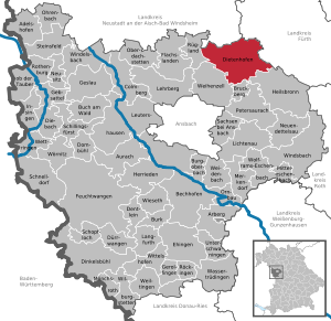
| Location of the Dietenhofen market in the Ansbach district | ||
  |
||

Dietenhofen is a market in the district of Ansbach in Middle Franconia .
geography
Geographical location
The community is located in the Frankenhöhe Nature Park about 28 km west of Nuremberg , 14 km northeast of Ansbach and 38 km east of Rothenburg ob der Tauber . The Bibert flows through the village and flows into the Rednitz near Zirndorf .
Community structure
There are 28 officially named parts of the municipality (the type of settlement is given in brackets ):
|
|
|
|
There is also the Warzfeldermühle and the Ziegelhütte , both of which are not officially named parts of the community.
Neighboring communities
The neighboring communities are:
| Rügland , Neuhof an der Zenn | Wilhermsdorf | |
.svg)
|
Großhabersdorf | |
| Weihenzell | Bruckberg , Petersaurach | Heilsbronn |
climate
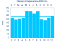
Diagram of precipitation mean values in Dietenhofen for the period from 1961 to 1990


In Dietenhofen, the average annual rainfall is 689 mm.
history
In 1235 the place was first mentioned by name as "Dietenhouen" in a document from the Heilsbronn Monastery . The place name contains the Germanic personal name Dieto , who can be seen as the founder of the place. The Dietenhofen moated castle was destroyed in 1523 and later rebuilt as a castle. The place belonged to the Hohenzollern Principality of Ansbach , which from 1500 was in the Franconian Empire .
In 1528, Dietenhofen, which was ecclesiastically under the patronage of Bamberg and ruled by Leonrod, accepted the Reformation according to the mandate given by Margrave Casimir in 1527. Dietenhofer's pastors Brechtel and chaplain Hiller had already had a reformist role in the early 1520s.
In the 16-point report of the Oberamt Ansbach from 1684 42 teams are listed for Dietenhofen: 1 property was owned by the Kastenamt Neuhof as landlord , 18 properties by the Teutonic Order Commander Nuremberg and 23 properties by the Lords of Leonrod . The high court south of the Bibert was exercised by the Brandenburg-Ansbach Hofkastenamt Ansbach , north of the Bibert by the Brandenburg-Bayreuth Stadtvogteiamt Markt Erlbach . The Ansbach court box office held village and community rulership.
At the end of the 18th century there were 67 properties in Dietenhofen. The high court was exercised by the municipal bailiff's office in Markt Erlbach, while the village and community rulership was held by the Brandenburg-Bayreuth caste office in Dietenhofen . The landlords were the Principality of Bayreuth (Kastenamt Dietenhofen, 56 properties: 2 mills, 1 bath room, 14 estates, 17 Gütlein, 16 houses, 6 drip houses ; Kastenamt Neuhof: 3 courtyards, 2 estates, 3 houses; Parish Dietenhofen : 1 little house) and that Neudorf manor (1 farm, 1 estate).
In 1792 the transition to Prussia took place . From 1797 to 1810 the place was subordinate to the Justice Office Markt Erlbach and Chamber Office Neuhof .
In 1810 Dietenhofen came to the new Kingdom of Bavaria . As part of the municipal edict , the tax district Dietenhofen was formed in 1811 , to which Andorf , Ebersdorf , Herpersdorf , Lentersdorf , Leonrod , Mosmühle , Oberschlauersbach , Rothleiten , Seubersdorf and Stolzmühle belonged. In 1813 the rural community of Dietenhofen was formed, to which the Mosmühle belonged. In the financial administration it was subordinate to the Rentamt Ipsheim , in the other administration and jurisdiction the district court of Markt Erlbach . For example, Johann Georg Lenz, a master of surgery in Dietenhofen, was on trial in Markt Erlbach in 1865 because he had sold drugs contrary to the existing regulations. However, until 1833 the Patrimonial Court of Neudorf held voluntary jurisdiction over two properties . From 1862 Dietenhofen was administered by the Neustadt an der Aisch district office (renamed Neustadt an der Aisch district in 1938 ) and from 1856 by the Markt Erlbach rent office (1920–1929: Markt Erlbach tax office , from 1929: Fürth tax office ). The jurisdiction remained with the district court of Markt-Erlbach until 1879, from 1880 to 1959 district court of Markt Erlbach , from 1959 district court of Fürth . The community originally had an area of 5,365 km².
The largest event in Dietenhofen during the Nazi era took place after the district manager (of the Neustadt / Aisch, Uffenheim and Scheinfeld district ) Otto Roth had already organized an advertising event for the NSDAP in Dietenhofen on December 6, 1931, in 1932, when at a large rally With more than 1000 participants, the regional cultural administrator of the Gaues Franken and Nuremberg city councilor Hans Bäselsöder (1900–1983) as well as the SA group leader and Reichstag member Wilhelm Stegmann appeared.
Incorporations
On July 1, 1969, the previously independent communities Ebersdorf and Leonrod were incorporated. On January 1, 1970, Herpersdorf and Seubersdorf were added. Neudorf followed on January 1, 1972. Kehlmünz and parts of the districts of Haasgang and Kleinhaslach, which had previously been part of the district of Ansbach , were reclassified to Dietenhofen on July 1, 1972. Territories of the dissolved community of Unternbibert were added on January 1, 1977. Götteldorf followed on May 1, 1978.
Population development
In the period from 1988 to 2018, the population increased from 4,441 to 5,573 by 1,132 or by 25.5%.
Dietenhofen community
| year | 1818 | 1840 | 1852 | 1861 | 1867 | 1871 | 1875 | 1880 | 1885 | 1890 | 1895 | 1900 | 1905 | 1910 | 1919 | 1925 | 1933 | 1939 | 1946 | 1950 | 1961 | 1970 | 1987 | 2005 | 2010 | 2015 |
|---|---|---|---|---|---|---|---|---|---|---|---|---|---|---|---|---|---|---|---|---|---|---|---|---|---|---|
| Residents | 505 | 659 | 637 | 599 | 662 | 653 | 637 | 619 | 606 | 599 | 622 | 609 | 657 | 686 | 703 | 762 | 732 | 758 | 1107 | 1162 | 1346 | 2610 | 4260 | 5322 | 5660 | 5572 |
| Houses | 80 | 101 | 113 | 118 | 125 | 144 | 163 | 248 | 1034 | 1515 | ||||||||||||||||
| source |
Place Dietenhofen
| year | 1818 | 1840 | 1861 | 1871 | 1885 | 1900 | 1925 | 1950 | 1961 | 1970 | 1987 |
|---|---|---|---|---|---|---|---|---|---|---|---|
| Residents | 505 | 651 | 593 | 644 | 600 | 602 | 755 | 1155 | 1344 | 1710 | 2360 |
| Houses | 80 | 100 | 117 | 124 | 143 | 162 | 247 | 547 | |||
| source |
politics
mayor
From 1984 to 2014 Heinz Henninger (PWG) was the first mayor of Dietenhofen. In the municipal elections in Bavaria in 2014 , he no longer ran. In a runoff sat Rainer Erdel , who for the electoral group of districts Dieterich Hofens (WHO) had set out with 62.9% of votes against Rainer Pfeiffer ( non-party voter community ), the 37% received by.
Market council
The market council consists of 20 members and the full-time mayor.
| CSU / Free Citizens | SPD | Non-party voter community | Voting group of the districts of Dietenhofen | total | |
| 2002 | 7th | 2 | 7th | 4th | 20 seats |
| 2008 | 6th | 1 | 8th | 5 | 20 seats |
| 2014 | 5 | 1 | 7th | 7th | 20 seats |
badges and flags
A jointly used seal from the turn of the 17th to the 18th century has been handed down for the Brandenburg offices of Dietenhofen and Bonnhof. King Maximilian II approved the continuation of the seal image as a coat of arms in 1858.
|
|
Blazon : "Standing in silver on green ground, a shepherd clad in blue with a golden bag, golden boots and a black slouch hat blowing a golden horn."
A white and blue flag with the municipality 's coat of arms is used as the unofficial municipal flag . |
| Justification for the coat of arms: The blowing man stands for the no longer understood place name, which was derived from "Düten", ie bubbles. This also explains the legend in connection with the coat of arms: Empress Kunigunde was lost and the night watchman's blowing brought her back on the right track. In fact, the place name is derived from the personal name Dieto. |
Community partnerships
- Zschorlau (Saxony)
- Flavignac (France), since 1982;
- Gresten-Land (Austria), since 2010
Others
From 2004 to 2016 Dietenhofen was part of the municipal alliance (Komm, A) to which the political communities Bruckberg, Heilsbronn, Neuendettelsau, Petersaurach and Windsbach also belonged. Since 2016, the community has been part of the Allianz Kernfranken , which arose from the merger of Komm, A and LiSa (Lichtenau, Sachsen b. Ansbach).
Architectural monuments


societies
- The local sports club is the TV 1909 Dietenhofen (including soccer, handball, athletics, ...).
- Ski Club Dietenhofen e. V. (focus: alpine skiing, cross-country skiing, grass skiing)
- Schützengesellschaft Dietenhofen e. V. founded in 1813
- TC Dietenhofen (tennis)
- Fischereiverein Dietenhofen e. V.
- The DLRG OV Dietenhofen has been providing swimming training for the citizens of Dietenhofen and the surrounding area since 1974.
- 1st Europe Music Train Dietenhofen
Economy and Infrastructure
traffic
The municipality is framed by the state road 2245 in the north and the St 2246 in the south and the St 2255 in the west. Accessible highways are the federal highway 14 in the southeast near Heilsbronn , the B 8 in the northeast near Langenzenn and the B 13 in the west near Graefenbuch . The closest motorway is the A 6 with the Neuendettelsau junction .
From the core town of Dietenhofen, the district road AN 11 leads north to state road 2245 near Neudorf . The AN 24 leads west via Leonrod to St 2245 near Andorf or east via Rothleiten and Lentersdorf to St 2245 near Münchzell . The AN 26 leads south to State Road 2246 near Kleinhaslach or north-east via Oberschlauersbach to St 2245. Community roads lead to Rüdern and Warzfelden to the AN 17 .
In the first half of the 1880s, the Ansbach – Dietenhofen – Markt Erlbach connection was established as a post bus route from the Nuremberg-Crailsheimer Bahn through the Bibert Valley. This lost its importance with the opening of the Bibertbahn on May 22nd, 1914. It ran through the local area until September 26th, 1971, until the opening of the section to Rügland on June 1st, 1915, Dietenhofen was the terminus. Even before the shutdown of the train service in September 1971, the rail bus connected the town with Nuremberg and Fürth. At the start of the transport association for the greater Nuremberg area in September 1987, the rail bus was fully integrated into the association as route 113. In 1988, the 100% railway subsidiary Omnibusverkehr Franken took over the concession .
At the beginning of the 1992 school year, the school bus route from Dietenhofen to the state secondary school in Heilsbronn and the Laurentius school center in Neuendettelsau was converted into bus route 717 from Neudorf.
Omnibusverkehr Franken also operates a bus route 129 via Markt Erlbach to Neustadt an der Aisch and a private transport company operates a route 716 to Ansbach.
In the evenings and on weekends, there is a collective taxi to Ansbach train station . A citizens' bus has been in use since March 1, 2019 to transport non-mobilized residents within the municipality.
Established businesses
- Geobra Brandstätter GmbH & Co. KG ("Playmobil")
- Herpa Miniaturmodelle GmbH
Personalities
- Rainer Erdel (* 1955), politician of the FDP
- Hans Hartmut Karg (* 1947), German educationalist
- Wilhelm Koch (1926–2018), local researcher for the city of Merkendorf
- Horst Brandstätter (1933–2015), entrepreneur and owner of the companies Playmobil and Lechuza (geobra), honorary citizen since 2013
- Andrea Schauer (* 1959 in Roßtal ), managing director of Playmobil and Lechuza ( geobra Brandstätter )
literature
- Johann Kaspar Bundschuh : Dietenhofen . In: Geographical Statistical-Topographical Lexicon of Franconia . tape 1 : A-egg . Verlag der Stettinische Buchhandlung, Ulm 1799, DNB 790364298 , OCLC 833753073 , Sp. 595 ( digitized version ).
- Hanns Hubert Hofmann : Neustadt-Windsheim (= Historical Atlas of Bavaria, part of Franconia . I, 2). Commission for Bavarian State History, Munich 1953, DNB 452071216 , p. 88 ( digitized version ). Ibid. S. 198 ( digitized version ).
- Georg Paul Hönn : Dietenhofen . In: Lexicon Topographicum of the Franconian Craises . Johann Georg Lochner, Frankfurt and Leipzig 1747, p. 239 ( digitized version ).
- Josef Kollar (Ed.): Markt Dietenhofen , Heilsbronn 1985.
- Georg Muck: History of Heilsbronn Monastery from prehistoric times to modern times . tape 2 . For Kunstreprod. Schmidt, Neustadt an der Aisch 1993, ISBN 3-923006-90-X , p. 325 (first edition: Beck, Nördlingen 1879).
- Wolf-Armin von Reitzenstein : Lexicon of Franconian place names. Origin and meaning . Upper Franconia, Middle Franconia, Lower Franconia. CH Beck, Munich 2009, ISBN 978-3-406-59131-0 , p. 54 .
- Hans Sponholz et al. (Ed.): District Neustadt an der Aisch . Verl. F. Authorities and Economy Hoeppner, Aßling-Pörsdorf / Obb. 1972, DNB 720137675 , p. 86-89 .
- Richard Strobel: District Neustadt an der Aisch (= Bavarian art monuments . Volume 32 ). Deutscher Kunstverlag, Munich 1972, DNB 730125742 , p. 50-56 .
- Pleikard Joseph Stumpf : Dietenhofen . In: Bavaria: a geographical-statistical-historical handbook of the kingdom; for the Bavarian people . Second part. Munich 1853, p. 714 ( digitized version ).
Web links
- Local government
- Dietenhofen: Official statistics of the LfStat
- Dietenhofen in the historical directory of the association for computer genealogy
Individual evidence
- ↑ "Data 2" sheet, Statistical Report A1200C 202041 Population of the municipalities, districts and administrative districts 1st quarter 2020 (population based on the 2011 census) ( help ).
- ↑ Mayor. Market town of Dietenhofen, accessed on June 6, 2020 .
- ^ Dietenhofen community in the local database of the Bavarian State Library Online . Bavarian State Library, accessed on September 14, 2019.
- ↑ W.-A. v. Reitzenstein, p. 54.
- ↑ Max Döllner : History of the development of the city of Neustadt an der Aisch until 1933. Ph. CW Schmidt, Neustadt ad Aisch 1950. (New edition 1978 on the occasion of the 150th anniversary of the Ph. CW Schmidt Neustadt an der Aisch publishing house 1828–1978. ) P. 194 f .
- ↑ Staatsarchiv Nürnberg , Ansbacher Salbuch 127, 584. Quoted from M. Jehle, Vol. 2, p. 681.
- ^ HH Hofmann, p. 88.
- ^ Address and statistical manual for the Rezatkreis in the Kingdom of Baiern . Buchdruckerei Chancellery, Ansbach 1820, p. 33 ( digitized version ). HH Hofmann, p. 223
- ^ Max Döllner : History of the development of the city of Neustadt an der Aisch up to 1933. Ph. C. W. Schmidt, Neustadt a. d. Aisch 1950, OCLC 42823280 ; New edition to mark the 150th anniversary of the Ph. C. W. Schmidt publishing house, Neustadt an der Aisch 1828–1978. Ibid 1978, ISBN 3-87707-013-2 , p. 527.
- ^ HH Hofmann, p. 198.
- ↑ a b c Bavarian State Statistical Office (ed.): Official city directory for Bavaria, territorial status on October 1, 1964 with statistical information from the 1961 census . Issue 260 of the articles on Bavaria's statistics. Munich 1964, DNB 453660959 , Section II, Sp. 804 ( digitized version ).
- ^ Wolfgang Mück: Nazi stronghold in Middle Franconia: The völkisch awakening in Neustadt an der Aisch 1922–1933. Verlag Philipp Schmidt, 2016 (= Streiflichter from home history. Special volume 4); ISBN 978-3-87707-990-4 , pp. 109 and 126.
- ^ Wilhelm Volkert (ed.): Handbook of Bavarian offices, communities and courts 1799–1980 . CH Beck, Munich 1983, ISBN 3-406-09669-7 , p. 535 .
- ^ Federal Statistical Office (ed.): Historical municipality directory for the Federal Republic of Germany. Name, border and key number changes in municipalities, counties and administrative districts from May 27, 1970 to December 31, 1982 . W. Kohlhammer, Stuttgart / Mainz 1983, ISBN 3-17-003263-1 , p. 706 f., 720 .
- ↑ a b Only inhabited houses are given. In 1818 these were designated as fireplaces , in 1840 as houses and from 1871 to 2015 as residential buildings.
- ↑ a b Alphabetical index of all the localities contained in the Rezatkreise according to its constitution by the newest organization: with indication of a. the tax districts, b. Judicial Districts, c. Rent offices in which they are located, then several other statistical notes . Ansbach 1818, p. 18 ( digitized version ).
- ^ A b Eduard Vetter (Ed.): Statistical handbook and address book of Middle Franconia in the Kingdom of Bavaria . Self-published, Ansbach 1846, p. 95 ( digitized version ).
- ^ A b c d e f g h i Bavarian State Statistical Office (Hrsg.): Historical municipality directory: The population of the municipalities of Bavaria from 1840 to 1952 (= contributions to Statistics Bavaria . Issue 192). Munich 1954, DNB 451478568 , p. 179 , urn : nbn: de: bvb: 12-bsb00066439-3 ( digitized ).
- ↑ a b Joseph Heyberger, Chr. Schmitt, v. Wachter: Topographical-statistical manual of the Kingdom of Bavaria with an alphabetical local dictionary . In: K. Bayer. Statistical Bureau (Ed.): Bavaria. Regional and folklore of the Kingdom of Bavaria . tape 5 . Literary and artistic establishment of the JG Cotta'schen Buchhandlung, Munich 1867, Sp. 1059 , urn : nbn: de: bvb: 12-bsb10374496-4 ( digitized version ).
- ↑ Kgl. Statistisches Bureau (Ed.): Directory of the municipalities of the Kingdom of Bavaria according to the status of the population in December 1867 . XXI. Issue of the contributions to the statistics of the Kingdom of Bavaria. Ackermann, Munich 1869, p. 168 ( digitized version ).
- ↑ a b Kgl. Statistical Bureau (ed.): Complete list of localities of the Kingdom of Bavaria. According to districts, administrative districts, court districts and municipalities, including parish, school and post office affiliation ... with an alphabetical general register containing the population according to the results of the census of December 1, 1875 . Adolf Ackermann, Munich 1877, 2nd section (population figures from 1871, cattle figures from 1873), Sp. 1225 , urn : nbn: de: bvb: 12-bsb00052489-4 ( digitized ).
- ↑ K. Bayer. Statistical Bureau (ed.): Community directory for the Kingdom of Bavaria. Manufactured due to the new organization of government districts, district offices and judicial districts. Addendum to issue 36 of the articles on Bavaria's statistics. Munich 1879, p. 67 ( digitized version ).
- ↑ K. Bayer. Statistical Bureau (ed.): Community directory for the Kingdom of Bavaria. Results of the census of December 1, 1880. Issue 35 of the articles on Bavaria's statistics. Munich 1882, p. 191 ( digitized version ).
- ↑ a b K. Bayer. Statistical Bureau (Ed.): Localities directory of the Kingdom of Bavaria. According to government districts, administrative districts, ... then with an alphabetical register of locations, including the property and the responsible administrative district for each location. LIV. Issue of the contributions to the statistics of the Kingdom of Bavaria. Munich 1888, Section III, Sp. 1159 ( digitized version ).
- ↑ a b K. Bayer. Statistical Bureau (Ed.): Directory of localities of the Kingdom of Bavaria, with alphabetical register of places . LXV. Issue of the contributions to the statistics of the Kingdom of Bavaria. Munich 1904, Section II, Sp. 1231-1232 ( digitized version ).
- ↑ a b Bavarian State Statistical Office (ed.): Localities directory for the Free State of Bavaria according to the census of June 16, 1925 and the territorial status of January 1, 1928 . Issue 109 of the articles on Bavaria's statistics. Munich 1928, Section II, Sp. 1269 ( digitized version ).
- ↑ a b Bavarian State Statistical Office (ed.): Official place directory for Bavaria - edited on the basis of the census of September 13, 1950 . Issue 169 of the articles on Bavaria's statistics. Munich 1952, DNB 453660975 , Section II, Sp. 1095-1096 ( digitized version ).
- ↑ a b Bavarian State Statistical Office (Hrsg.): Official local directory for Bavaria . Issue 335 of the articles on Bavaria's statistics. Munich 1973, DNB 740801384 , p. 168 ( digitized version ).
- ↑ a b Bavarian State Office for Statistics and Data Processing (Ed.): Official local directory for Bavaria, territorial status: May 25, 1987 . Issue 450 of the articles on Bavaria's statistics. Munich November 1991, DNB 94240937X , p. 325 ( digitized version ).
- ^ Dietenhofen: Official statistics of the LfStat
- ↑ Kommunalwahl_2002 ( Memento of the original from October 21, 2007 in the Internet Archive ) Info: The archive link was inserted automatically and has not yet been checked. Please check the original and archive link according to the instructions and then remove this notice.
- ↑ Kommunalwahl_2008 ( page no longer available , search in web archives ) Info: The link was automatically marked as defective. Please check the link according to the instructions and then remove this notice.
- ↑ Kommunalwahl_2014 ( page no longer available , search in web archives ) Info: The link was automatically marked as defective. Please check the link according to the instructions and then remove this notice.
- ^ Entry on the coat of arms of Dietenhofen in the database of the House of Bavarian History
- ↑ Dietenhofen. In: Kommunalflaggen.eu. Retrieved February 8, 2020 .
- ↑ www.kernfranken.eu
- ↑ Peter Ramsenthaler: Local Railway Nuremberg-Unternbibert-Rügland: From the Franconian metropolis to Rangau . H-und-L-Publ.-Souvenirs-Verlag Bleiweis, Schweinfurt 1996, ISBN 3-928786-48-2 , page 2
- ↑ Archive link ( Memento of the original from January 3, 2015 in the Internet Archive ) Info: The archive link was inserted automatically and has not yet been checked. Please check the original and archive link according to the instructions and then remove this notice.

Adelshofen | Arberg | Aurach | Bechhofen | Bruckberg | Book at the forest | Burgoberbach | Burk | Colmberg | Dentlein am Forst | Diebach | Dietenhofen | Dinkelsbühl | Dombühl | Dürrwangen | Ehingen | Feuchtwangen | Flachslanden | Gebsattel | Gerolfingen | Geslau | Heilsbronn | Herrieden | Insingen | Langfurth | Lehrberg | Leutershausen | Lichtenau | Merkendorf | Mitteleschenbach | Mönchsroth | Neuendettelsau | Neusitz | Oberdachstetten | Ohrbach | Ornbau | Petersaurach | Röckingen | Rothenburg ob der Tauber | Rügland | Saxony near Ansbach | Schillingsfürst | Schnelldorf | Schopfloch | Steinsfeld | Unterschwaningen | Wassertrüdingen | Weidenbach | Weihenzell | Weiltingen | Wettringen | Wieseth | Wilburgstetten | Windelsbach | Windsbach | Wittelshofen | Wolframs-Eschenbach | Wörnitz
Unregulated areas:
Lower Forest