
Rothenburg ob der Tauber
| coat of arms | Germany map | |
|---|---|---|

|
Coordinates: 49 ° 23 ' N , 10 ° 11' E |
|
| Basic data | ||
| State : | Bavaria | |
| Administrative region : | Middle Franconia | |
| County : | Ansbach | |
| Height : | 430 m above sea level NHN | |
| Area : | 41.68 km 2 | |
| Residents: | 11,391 (Dec 31, 2019) | |
| Population density : | 273 inhabitants per km 2 | |
| Postal code : | 91541 | |
| Area code : | 09861 | |
| License plate : | AN , DKB, FEU, ROT | |
| Community key : | 09 5 71 193 | |
| LOCODE : | DE RED | |
| City structure: | 39 parts of the community | |
City administration address : |
Marktplatz 1 91541 Rothenburg ob der Tauber |
|
| Website : | ||
| Lord Mayor : | Markus Naser (" FRV ") | |
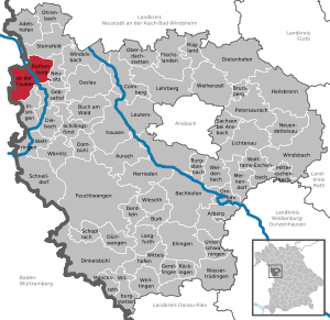
| Location of the city of Rothenburg ob der Tauber in the district of Ansbach | ||
  |
||


Rothenburg ob der Tauber is a small town in Central Franconia in the Ansbach district in Bavaria , which lies on the border with Baden-Württemberg .
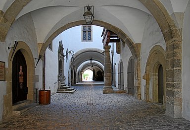
With the largely preserved medieval old town , the large district town of Rothenburg is a world-famous sight with many architectural monuments and cultural assets. What is outstanding about the old town is that it looks very original, as despite the war destruction of 1945 and the simple, inconspicuous reconstruction, practically no modernist breaks are discernible. The historic town center is surrounded by a walk-through town fortification and embedded in the largely unspoilt landscape of the Tauber river valley . For decades, attempts have been made to preserve this originality as much as possible. Rothenburg is also known for several museums, such as the crime museum, the RothenburgMuseum (until 2019 Reichsstadtmuseum ), the craftsman's house and the Käthe Wohlfahrt Christmas museum . The nationally known events include the Meistertrunk ( cultural heritage since 2016), the Reichsstadttage, the Christmas market and the Taubertal Open-Air Festival .
From 1274 to 1803 Rothenburg was an imperial city . After the Thirty Years War , the city lost its importance. Although it remained the center of an extensive country area and a cultural center, it only developed gradually, which largely retained the old townscape . In the 19th century the city “petrified” not least because of its border location with Württemberg. There were approaches to industrialization, but there was no railway connection until 1881. Rothenburg was already an important tourist destination in Germany before the Second World War . After destruction in the Second World War, only the most important buildings were faithfully rebuilt . But thanks to a clever, unique concept, the reconstruction of the 1950s and 1960s met both the requirements of monument protection and modern living. A visitor will only recognize the buildings, which were built after 1945, at second glance, although they by no means seem romanticized and kitschy. From 1950 the city became one of the highlights on the Romantic Road , Germany's first holiday route. Until 1972 it was independent and the seat of the district of the same name . The city and district then became part of the district of Ansbach and Rothenburg was elevated to a large district town with certain rights of self-government.
geography
Geographical location

Rothenburg ob der Tauber is located about 80 km west of Nuremberg on the Tauber River and on the edge of the Frankenhöhe Nature Park . In geological and geomorphological terms, the eaves of the Frankenhöhe is located east of the city.
City structure
The municipality has 39 officially named parts of the municipality (the type of settlement is given in brackets ):
|
|
|
|


Neighboring communities

The neighboring municipalities are (clockwise, starting in the north):
- Stone field
- Neusitz
- Gebsattel
- Insingen
- Rot am See (Baden-Württemberg)
- Blaufelden (Baden-Wuerttemberg)
- Schrozberg (Baden-Wuerttemberg)
- Creglingen (Baden-Wuerttemberg)
history

Until the 13th century

The counts of Comburg-Rothenburg built west near the present Spitalhof on a mountain spur called vinegar jug a now Outbound castle (the Comburg is Schwäbisch Hall, the local counts were very influential in the 11th and early 12th century). The first mention of a Count of Rothenburg takes place in the 11th century. Older traditions are fabulous and wrong. Count Heinrich von Rothenburg, the last member of this noble family, which died out in 1116, bequeathed the castle to the Comburg monastery founded by his family .
King Conrad III. In 1142 acquired the village of Detwang from the Neumünster canons in Würzburg , to which the Bergsporn northwest of today's city belonged, and built Rothenburg Castle on the area of today's castle garden . A stay of Konrad in Rothenburg is documented for 1150. Next to this castle above the Tauber, a town emerged, from whose geographical location the addition of the name ob der Tauber is derived. The castle may have been destroyed or at least damaged by an earthquake around 1356 . There is no consensus on this in historical research.
At the end of the 12th century, the settlement next to the castle slowly developed into a town. Until the middle of the 13th century it was protected by a fortification ring and had a market square, a church, a Dominican nuns - and a Franciscan monastery . The Teutonic Order had had a branch, the Kommende Rothenburg, since the 13th century .
Imperial city
The elevation of Rothenburg to an imperial city took place on May 15, 1274 by King Rudolf von Habsburg . The most prominent figure of the Middle Ages was Heinrich Toppler (approx. 1340–1408), who - naturally in cooperation with his colleagues from the urban patriciate - influenced the fate of the city far beyond his controversial death with his energetic politics and land purchases. In the years 1406 and 1408 attacks by Neustädter took place . In 1474, the King of Denmark, Norway and Sweden, Christian I, stayed for a week in an inn on the market (today the council chamber ).
The Jewish community of Rothenburg was one of those common in German cities at the time, and by no means one of the oldest in Germany, as Rothenburg was a rather younger, at most medieval city. The Rabbi Meir von Rothenburg (around 1220-1293) emerged from it. During the rint meat pogrom of 1298, almost the entire community, around 450 people, was murdered. Jews soon settled in the city again. The newly formed community fell victim to another pogrom in the plague year of 1349. Even afterwards Jews settled in Rothenburg again. In 1520, the city preacher Johannes Teuschlein obtained a final expulsion. The community's property was confiscated. The synagogue on the Kapellenplatz was converted into a chapel "to the Reine Maria". Only in the 19th century were Jews able to settle in Rothenburg again.
Around 1400 a small Terziarenkloster was built on today's Brudergäßchen . The monastery existed until 1541 and was demolished in 1579. From 1500 to 1806 the city was part of the Franconian Empire .
As early as 1522 there were some supporters of the Reformation in the citizenry and in the council. With the end of the Peasants' War in 1525, the old belief was re-established. The council decided in 1544 to introduce the Reformation in Rothenburg and brought Thomas Venatorius to the city as a preacher, who read the first Protestant sermon in Rothenburg on March 23, 1544. The German and the Order of St. John remained Catholic, they had to give up their churches St. Jakob and St. Johannis. The mayor and council of Rothenburg auf der Tauber signed the Lutheran concord formula of 1577 in 1579 .
Thirty Years' War

The Thirty Years' War was a problem for Rothenburg from the start. As a Protestant imperial city, it was committed to allegiance to the Catholic Emperor Ferdinand II. On the other hand, it sympathized with the Protestant side. King Gustav Adolf of Sweden defeated the imperial troops in the battle of Breitenfeld in September 1631 , pushed further south and occupied Würzburg in mid-October . The Catholic general, Count von Tilly, tried to build a new line of defense in Franconia . So Rothenburg, which was actually insignificant militarily and politically, got caught between the fronts.
At the beginning of October 1631 there were 800 imperial troops in the city. On October 7th, near Rothenburg, an imperial unit of the War Commissioner Alessandro Massoni was defeated by Swedish troops. On October 8, the imperial occupation of Rothenburg surrendered to the Swedish troops without besieging the city. Parts of the imperial troops mutinied and joined the Swedes, the rest were allowed to leave freely. The Swedes then occupied Rothenburg. Two weeks later Tilly reached the area with the main force of the imperial army. On October 27, Rothenburg's council was asked by the imperial army to initiate surrender negotiations. Since he refused, the imperial troops closed a siege ring around the city on October 29th. The citizens of Rothenburg prepared to defend the city together with the Swedish occupation; Probably there was hope for relief by the Swedes from Würzburg. On October 30th the shelling of the city began, especially from the north between Klingen- and Galgentor. The defenders inflicted heavy casualties on the attackers (around 300 men), but when gunpowder stored in the blade gate bastion caused an explosion , the Swedish crew stopped fighting. The Swedes were allowed to withdraw after a short negotiation.

Probably on the night of October 30th to 31st, the city was given up for sacking . The city council was arrested and threatened with death. But he managed to prove that the city had no part in the destruction of the troops of War Commissioner Massoni and the mutiny of the original imperial occupation. Probably the townspeople had also gathered in the market square and asked for mercy. It can be assumed that Tilly spared the city because he did not want the events of Magdeburg , in which his troops had massacred the population and burned the city to the ground a few months earlier, to be repeated. The bloody deed in Magdeburg also explains the fear that the Rothenburgers of the time must have felt when the Tilly army approached.
According to a story that was first invented around 1770, the former mayor Georg Nusch is said to have emptied 3.25 liters of wine on a train on the orders of General Tilly and thus saved the city from destruction. For this (alleged) occasion, the annual festival called Der Meistertrunk has been held since 1881 . Historians are certain that such a “master drink” never existed. The Rothenburg chronicler and eyewitness Sebastian Dehner described the events of the siege and capture without the "master drink".
The looting was finally stopped, the city had to pay a fine and put up with the billeting of the imperial soldiers. For the population this meant further attacks by soldiers, hunger and infectious diseases . On January 13, 1632, the imperial troops left the city.
18th and 19th centuries
After the Thirty Years' War, the city allegedly fell into a kind of deep sleep. The development is said to have stood still and the city lost its importance. That can be one reason why the city and its old buildings are in such a well-preserved condition. On the other hand, Rothenburg was a conservative imperial city in the second half of the 17th and 18th centuries, but also spiritually and economically up to date.
Since the Reichsdeputationshauptschluss of 1803, the city has been part of the Electorate of Bavaria . On the basis of the Paris Treaty of February 28, 1810 between France and Bavaria, the object of which was an agreement on regional consolidation, the border treaty between the Kingdom of Bavaria and the Kingdom of Württemberg dated May 18, 1810, in which the western part of the urban area was then was lost to Württemberg .
With the community edict (early 19th century), the Royal City Commissioner Rothenburg was formed. The immediate municipal community included the places Bloshaus, Bronnenmühle, Detwang, Dürrenhof, Fuchsmühle, Gypsmühle, Haltmühle, Hammerschmiede, Hansrödermühle, Herrenmühle, Hirtenhaus, Hohbach, Kaiserstuhl, Langenmühle, Ludlesmühle, Lukasrödermühle, Rothe, Pulvermühle, Leonasrödermühle, Obere Walkmühle, paper mill , Schandhof, Schandtauberthal, Schlößlein, Schmelzmühle, Schwabenmühle, Schwarzenmühle, Siechenmühle, Stegmühle, Steinbach, Steinmühle, Untere Walkmühle, Weißenmühle, Wildbad and Zellergut. The municipality had an area of 20.967 km².
In 1870 the then 19-year-old landscape painter Gustav Schönleber visited Rothenburg, followed in 1877 by Eugen Bracht, who was visibly impressed, and from 1880 onwards, other painters, particularly from the late Romantic period, including Hans Thoma and Carl Spitzweg, followed . Soon the city also became a tourist destination. In 1884 it was first built outside the city wall. By the turn of the century, Rothenburg became a popular tourist destination for the English and French. Even before the First World War , excursion buses arrived with upscale company that resided in the Hotel Eisenhut, which still exists.
20th and 21st centuries

During the Weimar Republic , the city and constituency of Rothenburg developed into a stronghold of the NSDAP , which in 1933 received 83 percent of the vote there. In the same year there were anti-Semitic attacks in Rothenburg . In October 1938, shortly before the Reichspogromnacht , the last 17 remaining Jews were expelled from the city by NSDAP district leader Steinacker, and SA men and Hitler Youth carried out the expulsion. On October 22nd, the inventory of the synagogue at Herrngasse 21 was looted and destroyed. In Rothenburg there was a "celebration of joy" on the occasion of the "liberation from the Jews".


On March 31, 1945, shortly before the end of World War II , around 45% of Rothenburg's buildings were damaged or destroyed by a squadron of the 386th Bombardment Group of the US Air Force , killing 39 people. The bombing attack was aimed at an oil storage facility in Ebrach , Upper Franconia , which could not be attacked because it was fogged, so that Rothenburg was attacked as a substitute target, although it was of no military importance. The destruction mainly affected the newer eastern part of the old town, so that the most important architectural monuments were preserved. After the war, the buildings were rebuilt or renovated true to the original. The pilots questioned later said they had no idea which cultural city they were bombing. After the end of the war, the Americans took part in the reconstruction with donations, as the donor boards on the battlement still show.
On April 17, 1945 the war ended for the Rothenburgers, while elsewhere the fighting continued for three weeks. The then US - High Commissioner for Germany , John McCloy , declared in 1950 in writing that he had a plan to Rothenburg artillery attack by its intervention with the competent General Devers prevented. For this he was later given honorary citizenship by the city. McCloy only knew Rothenburg from stories told by his mother, who had visited the city before the war and raved about the medieval place.
Until 1972, the city was independent and the seat of the district of the same name , which is why it had its own ROT license plate . With the Bavarian regional reform , the city and district were assigned to the district of Ansbach with effect from January 1, 1972. However, the city retained the status of a major district town. It is the smallest large district town in Bavaria. Since July 10, 2013, the RED label is officially available again for new registrations.
Since half of the tourists in Rothenburg ob der Tauber came from abroad before the Covid-19 pandemic , many retail stores in the city struggled to survive in 2020.
Incorporations
On July 1, 1972, the previously independent municipality of Leuzenbronn was incorporated. Bettenfeld was added on May 1, 1978.
Population development
In the period from 1988 to 2018, the population increased from 11,071 to 11,243 by 172 inhabitants or 1.6%.
Rothenburg ob der Tauber community
| year | 1818 | 1840 | 1852 | 1861 | 1867 | 1871 | 1875 | 1880 | 1885 | 1890 | 1895 | 1900 | 1905 | 1910 | 1919 | 1925 | 1933 | 1939 | 1946 | 1950 | 1961 | 1970 | 1987 | 2002 | 2011 | 2015 | 2016 | 2017 | 2018 |
|---|---|---|---|---|---|---|---|---|---|---|---|---|---|---|---|---|---|---|---|---|---|---|---|---|---|---|---|---|---|
| Residents | 5662 | 5197 | 5125 | 5049 | 5236 | 5382 | 5773 | 6504 | 6826 | 7001 | 7193 | 7923 | 8436 | 8612 | 8556 | 8828 | 9022 | 9176 | 11045 | 11214 | 11134 | 11662 | 11059 | 11631 | 10953 | 11041 | 11085 | 11106 | 11287 |
| Houses | 876 | 834 | 853 | 914 | 953 | 1035 | 1260 | 1287 | 1677 | 2625 | |||||||||||||||||||
| source |
District of Rothenburg ob der Tauber
| year | 1818 | 1840 | 1871 | 1885 | 1900 | 1925 | 1950 | 1961 | 1970 | 1987 |
|---|---|---|---|---|---|---|---|---|---|---|
| Residents | 5302 | 5197 + | 4851 | 6221 | 7387 | 8265 | 10494 | 10511 | 11237 † | 10336 * |
| Houses | 803 | 834 + | 860 | 930 | 1172 | 1203 | 1599 | 2432 * | ||
| source |
gallery

Renaissance facade of the town hall with a baroque arcade porch, behind it the Gothic part with a 60 meter high tower
Historical vault in the Gothic part of the town hall

So-called Hegereiterhaus from 1591
Hospital gate from the 16th century

Fleisch- und Tanzhaus (left) and Jagstheimerhaus (right) on the market square (2014)

View over the market square and the city, photographed from the town hall tower (2014)

Röderbogen (2011)
Blade Gate (2010)

Gerlachschmiede and Rödertorturm (2017)
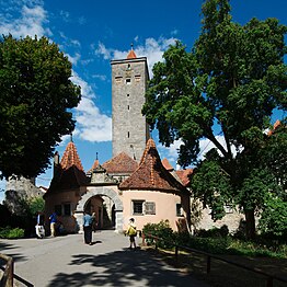
The Castle Gate (2015)


-damir-zg.jpg)
.jpg)
politics
City council
The city council of Rothenburg ob der Tauber has 24 members. With the Free Rothenburg Association (FRV) and the Voters' Association Independent Rothenburg (UR), Rothenburg has two local, party-independent groups of voters.
The distribution of seats at a glance:
| CSU | SPD | Green | FRV | UR | FDP | total | |
| 2002 | 9 | 8th | 2 | 4th | - | 1 | 24 seats |
| 2008 | 6th | 8th | 2 | 5 | 3 | 0 | 24 seats |
| 2014 | 6th | 6th | 3 | 5 | 4th | 0 | 24 seats |
| 2020 | 6th | 5 | 4th | 5 | 4th | - | 24 seats |
mayor
The office of mayor has existed in Rothenburg since 1336. Due to its status as a major district town, Rothenburg is entitled to elect a mayor - even after the Rothenburg ob der Tauber district has been dissolved. This makes Rothenburg the smallest German city with a Lord Mayor. In the 2006 election, Walter Hartl won, who stood for the non-party group “For Rothenburg” and was supported by the SPD in the second ballot. Hartl has been in office since May 2, 2006. He succeeded the long-time mayor Herbert Hachtel ( SPD ), who no longer stood for election. In the OB election in March 2012, Hartl (he was the only candidate) was re-elected with 90.2% of the vote.
Mayor of the Inner and Outer Council
- Heinrich Toppler (1340–1408)
- Peter Northeimer
- Heinrich Trüb
- Ehrenfried Kumpf
- Bonifacius Wernitzer, in office from 1525 to 1546
- Andreas (Endres) Stellwag (1525–?)
- Johann Hornburg
- Michael Reichshöfer (1545–?)
- Josaphat Stellwag (1558–?)
- Johann Staudt (1567–1634)
- Johann Bezold (1582–1634)
- Georg Nusch (1588–1668)
- Johann Georg Styrzel (1591–1668)
- Johann Stellwag (1607)
- Nicolaus Göttlingk (1608–1679), in office from 1655 to 1679
- Philipp Seyboth
- Johann Gottlieb Ebert
- Christoph Friedrich Albert (1749-1831)
- Johann Friedrich Christoph Schrag
- Gustav David Bezold
- Johann Christoph Raab
List of legally qualified mayors
- 1848–1851: Friedrich Karl Julius Wächter
- 1852–1883: Georg Gottfried Scharff
...
- 1886–1907: Karl Mann
- 1908–1919: Ludwig Siebert , Bavarian People's Party
- 1920–1936: Friedrich Liebermann, NSDAP
- 1936–1945: Friedrich Schmidt, NSDAP
List of Lord Mayors
- 1945–1952: Friedrich Hörner , SPD
- 1952–1964: Erich Lauterbach (1879–1966), independent
- 1964–1976: Alfred Ledertheil, SPD
- 1976–1988: Oskar Schubart, CSU
- 1988–2006: Herbert Hachtel (* 1941), SPD
- 2006–2020: Walter Hartl (* 1956), non-party
- 2020–: Markus Naser (* 1981), non-party, candidate of the Free Rothenburg Association (FRV)
Town twinning
Rothenburg ob der Tauber maintains city partnerships with
Furthermore, there are official city friendships with
-
 Montagnana ( Italy ), since 1983
 -
 Czerwieńsk ( Poland ), since 1990
 -
 Telč ( Czech Republic ), since 1992
A partnership with the Chinese city of Jingjiang has existed since October 2004.
![]()
There are also long-term friendships with other Rot (h) enburgs:
coat of arms
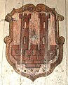
Blazon : "In silver, a red castle, consisting of a wall cut into arches on both sides, surmounted by two red pinnacle towers, enclosing a pointed red house on two posts."
Declaration and history of the coat of arms: The castle made of wall and towers with the house, the court arbor , symbolizes the name of the city of Rothenburg as a talking coat of arms . Other representations of the coat of arms, especially in the 19th century, show a three-pinned wall beveled on both sides below without the house. The city of Rothenburg uses a similar coat of arms on its historical information boards.
The oldest seal dates from the year 1303. It shows the inscription S [IGILLUM] CONSILII ET VNIVERSITATIS CIVIVM IN ROTENBVRCH (German: Seal of the Council and the Totality of the Citizens in Rothenburg). Between the two tin towers there is a small house with a pointed roof on two pillars or walls and an open front - the so-called court arbor - a possible reference to the district court seat. The two-tower castle comes from the seal of the Rothenburg Burgvögte and Schultheißen from 1227 from the family of the chefs from Nortenberg. Since 1555, instead of the castle, the coat of arms has shown the imperial eagle from the seal of the imperial district court with breast shield, in it the city coat of arms with the castle. In the 19th century the castle was again without an eagle in the coat of arms, often without a court arbor.

City seal from 1320

Coat of arms with court arbor

Flag with imperial eagle and Rothenburg breastplate
Coat of arms without a house

Current coat of arms of the city administration

.jpg)


Economy and Infrastructure
tourism
Rothenburg is strongly influenced by tourism and is known as a Franconian wine town on the Tauber with the Rothenburger Eich location . There is also a grape variety trail with over 120 different grape varieties . The city of Rothenburg forms the southernmost point of the extensive Franconian wine country. In Rothenburg there are not only many long-established wine bars but also a self-expanding winery. Most of the wine produced is sold to tourists; viticulture used to be an important industry.
Historical old city

Rothenburg is known for its well-preserved old town from the Middle Ages with many nested alleys, towers and small squares surrounded by half-timbered houses. Because of this, the city became a magnet for tourists from all over the world; abroad it is considered the prototype of a medieval German city. Visitors from Asia in particular stop here on organized trips through Europe. In addition to hotels and inns, the city offers a nearby campsite and two motorhome parking spaces as well as a youth hostel , which is housed in the city's former Rossmühle .
Because of the well-preserved old town, Rothenburg served as a backdrop for numerous film productions (see section: Rothenburg as a film set ).
Tourist routes
The Romantic Road leads from Würzburg via the Taubertal to Rothenburg. From there it continues to Füssen . Besides being Romantic Road Rothenburg of the running in east-west direction Castle Road crossed.
Biking and hiking trails
Rothenburg od T. is also touched by numerous cycle paths. The best known of these is the Taubertal cycle path . Its main variant " Lovely Taubertal - the classic" begins in Rothenburg and runs for 100 km to Wertheim . The supplemental Route "Tauber Valley - the Sporty" leads to 160 additional kilometers through the main and Tauber up to Rothenburg back along the cycling route "Tauber Valley - the classic" consists from Bieberehren over the Gaubahn cycle path connects to the main cycle path at Ochsenfurt.
An alternative route of the Main-Tauber-Franconian wheel eight leads via Rothenburg ob der Tauber.
The Altmühltal Cycle Path extends for 250 km from Rothenburg ob der Tauber in the northwest to Kelheim at the confluence of the Altmühl into the Danube in the southeast. The Aisch valley cycle path connects Rothenburg ob der Tauber with Bamberg am Main cycle path over a length of 137 kilometers . The path runs through the valley of the Aisch .
The 130 km Taubertal Panorama Trail begins and the 180 km Main-Taubertal Way of St. James ends in the city.
The Franconian Marienweg runs through Rothenburg ob der Tauber .
traffic
.jpg)

Road traffic
Rothenburg ob der Tauber is located on the A 7 motorway with the Rothenburg ob der Tauber junction a short distance from the city.
The national road 2419 is parallel to A 7 from north to south as their escape route.
Rail transport
The city is the end point of the railway line from Steinach on the main line from Würzburg to Ansbach, which opened on November 1, 1873 . The regional train line R82 operates here in the transport association for the greater Nuremberg area .
From 1905 to 1971 the line ending in Rothenburg via Schillingsfürst to Dombühl on the main line Ansbach – Crailsheim was used.
Air traffic
About three kilometers northeast of the city is the Rothenburg ob der Tauber airfield .
Established businesses
Rothenburg is home to a plant of the large household appliance manufacturer Electrolux (a former AEG plant ), a spare parts center of the large construction machinery manufacturer Yanmar , medium-sized mechanical engineering companies and, with D. Lechner GmbH, Europe's second largest producer of kitchen worktops . There are also other well-known companies in the city:
- Ebalta (plastics, casting resins, adhesives)
- Käthe Wohlfahrt (Christmas decorations)
- Neuberger building automation
- Rotabene Medienhaus (including: Fränkischer Anzeiger and Evangelisches Sonntagsblatt from Bavaria )
Culture and sights
Museums

- RothenburgMuseum (until 2019 Reichsstadtmuseum ) in the former Dominican convent with the municipal collections, the collections of the Alt-Rothenburg Association and the Baumann Foundation
- The Medieval Crime Museum is the most important German legal museum and gives an insight into the legal events of the last 1000 years; Exhibits include instruments of torture and execution, neck violins , disgraceful masks , judging swords, judging wheels, medieval legal texts and instructions on witch trials
- Shepherd's dance museum in the Wolfgangskirche
- Old Rothenburg craftsman's house, which shows the everyday life of craftsman families in Rothenburg in eleven rooms
- Historical vault with state dungeon in the town hall
- German Christmas Museum (private, part of the Käthe Wohlfahrt company )
- Doll and Toy Museum (private, closed since 2014)
Buildings


Churches
- St. Jacob's Church with Holy Blood reredos by Tilman Riemenschneider ; Another Riemenschneider Altar (Holy Cross Altar) is in the Detwanger Church
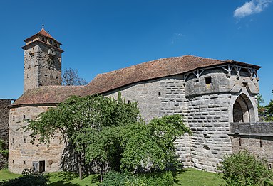
- Wolfgangskirche am Klingentor ( fortified church )
- Blasius Chapel in the Burggarten , a residential building of the former imperial castle that was converted into a sacred building in 1400; today a memorial for the fallen of the two world wars
- Dominican convent (today RothenburgMuseum)
- Franciscan Church
- St. John's Church with Steinmeyer organ
Further
- City wall with battlements and towers, inner city wall around 1172, outer city wall around 1360–1388
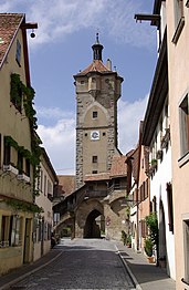
- City gates: Klingentor (north), Würzburger or Galgentor (northeast), Rödertor (east), Sieberstor (south gate), Spitaltor (1556, south), Kobolzellertor (Taubertal), Burgtor (west), White Tower (1st city wall, northeast gate ), Markus tower with Röderbogen (1st city wall, east gate)
- Plönlein ("Plänlein" - from Latin planellum: small plain, square), fork in the road and former fish-stacking area with half-timbered houses and a view of Sieberstor and Kobolzellertor
- Spitalbastei, a barbican with a drop roof built by the Rothenburg master builder and stonemason Leonhard Weidmann
- Hospital preparation house, built by Leonhard Weidmann in 1591; Former official residence of the hospital operator and the hospital kitchen. The hospital rider was head of administration and property manager of the Heilig-Geist-Spital in today's sense. Due to romanticizing historicism, the building is erroneously referred to as the Hegereiterhaus. It has nothing to do with the Hegereitern, who were responsible for the Rothenburger Landhege , because they lived in the places they were responsible for.
- Builder's house, work and home of stonemason Leonhard Weidmann
- Staufer stele in the castle garden in memory of the Staufer King Konrad III in 1142 . founded Reichsburg , which was probably damaged in an earthquake in 1356 and then removed (inaugurated in 2010)
- Topplerschlösschen in the Taubertal
- Double bridge over the Tauber
- Wildbad Rothenburg , built between 1898 and 1903 by Friedrich Hessing as a spa hotel; since 1982 it has been used as a Protestant conference center
- Historic town hall with bell tower; the town hall tower offers a viewing platform at a height of 60 meters , which can be reached via 220 steps
- Rattrinkstube (1466) with art clock (figures by Valentin Oeckler ), which shows the legendary master drinking scene every full hour from 11 a.m. to 3 p.m. and from 8 p.m. to 10 p.m.
- Old brewery
- Old Forge
- Jewish Cemetery
- Judentanzhaus

Regular events


- The historical festival “ The Master Drink ” at Pentecost
- The minters of Rothenburg ob der Tauber
- Imperial City Days
- Taubertal Festival
- Christmas market "Reiterlesmarkt"
- Shepherd dance
- Church music in St.Jakob
- Toppler theater
- Folk festival with grocer's market
- Autumn fair
Personalities
sons and daughters of the town


- Heinrich Toppler (around 1340–1408 in Rothenburg), mayor and councilor
- Friedrich Herlin (around 1430–1500), painter
- Johann Haller (1463–1525), printer
- Petreius Aperbacchus (around 1480–1531), humanist
- Valentin Ickelsamer (around 1500–1547), educator
- Hans Baumann (around 1510–1570), printer and chronicler
- Georg Conrad Jung (1612–1691), printer, painter, engraver , geographer and cartographer
- Johann Ludwig Hartmann (1640–1680), theologian and folk writer
- Johann Georg Joch (1676–1731), Protestant theologian
- Johannes Balthasar Wernher (1677–1743), legal scholar and mathematician
- Johann Adam Lehmus (1707–1788), Protestant pastor and poet
- Johann Georg Model (1711–1775), pharmacist at the Tsar's court in Saint Petersburg
- Johann Augustin Philipp Gesner (1738–1801), physician and pioneer in research into aphasia
- Karl Georg Christian von Staudt (1798–1867), mathematician
- Georg Wilhelm Wanderer (1803–1863), genre and portrait painter
- Gustav Kraus (1804-1852), lithographer
- Friedrich Wilhelm Walther von Walderstötten (1805–1889), infantry general and cartographer
- Friedrich Lehmus (1806–1890), pastor and founder of one of the first children's detention centers in Germany
- Franz von Leydig (1821–1908), zoologist
- Hanno Bernheim (1824–1862), philosopher
- Ernst Leybold (1824–1907), businessman and entrepreneur
- Adam Hörber (1827–1905), poet and master glazier . Author of the play Der Meistertrunk
- Gustav von Bezold (1828–1892), Reich judge
- Friedrich Bezold (1842–1908), ENT specialist
- Fritz Birkmeyer (1848–1897), draftsman , painter, glass painter and illustrator
- Leonhard Vogel (1863–1942), veterinarian
- Martin Weigel (pastor) (1866–1943), Protestant city pastor in Rothenburg (1895–1921) and Nuremberg as well as local history researcher and National Socialist
- Franz Boll (1867–1924), classical philologist , science historian and librarian
- Wilhelm Borkholder (1886–1945), lawyer and Lord Mayor of Ansbach
- Willi Foerster (1892–1965), painter
- Friedrich Uebelhoer (1893–1945), politician ( NSDAP )
- Wilhelm Heer (1894–1961), politician (NSDAP), member of the Reichstag
- Hans Kern (1898–1984), football official , manager and politician
- Hans Böhme (1905–1982), landscape painter, etcher and draftsman
- Kurt Frör (1905–1980), Protestant clergyman and university professor
- Linus Memmel (1914-2004), politician ( CSU ), Member of the Bundestag
- Wilhelm Staudacher (1928–1995), poet and dialect poet
- Viktor Lukas (* 1931), organist and university professor
- Ulrich Fleischmann (1938–2011), Caribbean researcher
- Christof Stählin (1942–2015), writer , songwriter , cabaret artist
- Otto A. Böhmer (* 1949), writer
- Horst F. Rupp (* 1949), Protestant theologian and religious educator
- Klaus Pohl (* 1952), actor , theater director and screenwriter
- Ruth Lindner (1954–2008), Classical Archaeologist
- Karl Borchardt (* 1956), historian
- Günter Röhser (* 1956), Protestant theologian and university professor
- Thomas Jorberg (* 1957), board spokesman of the GLS community bank
- Angela Christlieb (* 1965), film director and video artist
- Christian Mittermeier (* 1965), cook
Personalities associated with Rothenburg

- Meir von Rothenburg (1215–1293), famous rabbi and Talmud scholar
- Wilhelm Ziegler (around 1480–1543), painter with Rothenburg citizenship
- Johannes Teuschlein (1483–1525), theologian and reformer , beheaded in Rothenburg during the Peasants' War
- Johannes Böhm (1485–1534), humanist and member of the Teutonic Order
- Andreas Bodenstein (Karlstadt) (1486–1541), theologian and priest, university professor and reformer
- Thomas Venatorius (1488–1551), mathematician and theologian. In 1544 he helped reintroduce the Reformation in Rothenburg.
- Primož Trubar (1508–1586), theologian and deacon in Rothenburg from 1548 to 1552, is considered the founder of Slovenian literature as well as the Evangelical Church in Slovenia and is called the Luther of Slovenia .
- Andreas Libavius (1555–1616), chemist , polymath
- Erasmus Widmann (1572–1634), composer and organist
- Georg Siegmund Leyser (1662–1708), organ builder , created e.g. B. the baroque organ in St. Andreas ( Leuzenbronn )
- Franz Vollrath Buttstedt (1735–1814), composer and organist
- Johann Michael Schiller (1763–1825), pharmacist, chemist and teacher. Founder of the Marienapotheke
- Arthur Wasse (1854–1930), painter. The Briton moved to Rothenburg in 1895 in the Klingentorbastei 1a and lived there until his death. He is buried in Rothenburg.
- Elise Mahler (1856–1924), painter and graphic artist . Mahler had an art shop with Maria Ressel on Georgengasse.
- Peter Philippi (1866–1945), painter. Co-founder of the Rothenburg Artists Association
- Ludwig Siebert (1874–1942), politician , Mayor of Rothenburg from 1908 to 1919, later as NSDAP member Bavarian finance minister and then Prime Minister , SA group leader; In Rothenburg a street was named after him until 2015
- Johann Peter Werth (1876–1960), German painter, graphic artist and illustrator, who worked extensively for the Spear-Spiele company (died in Rothenburg)
- Maria Ressel (1877–1945), painter, graphic artist and illustrator , lived and works from 1896 to 1912 in Rothenburg
- Constantin von Mitschke-Collande (1884–1956), painter, wood cutter and lithographer , lived and works in Rothenburg from 1945 to 1952. Was a member of the Rothenburg Artists' Association.
- Adolf Meyer (1895–1966), councilor in Wilhermsdorf, NSDAP district leader in Neustadt an der Aisch and from 1937 to 1945 school councilor in Rothenburg.
- Franz Bi , born Franz Bartlakowski (1899–1968), architect and film architect
- Ernst Unbehauen (1899–1980), painter and elementary school teacher, worked mainly in Rothenburg
- Rolf Trexler (1907–1985), puppeteer; directed the internationally known puppet theater Der Lustigmacher in Rothenburg
- Sadie Walker († shortly after World War II), American concert violinist and Fritz Kreisler student, lived in the vineyards between Rothenburg and Detwang from 1932
- Hans Karl Adam (1915-2000), TV chef
- Bernhard Doerdelmann (1930–1988), publishing director and poet
- Pope Franziskus (Jorge Mario Bergoglio) (* 1936) lived in Rothenburg on Judengasse from August to October 1986
- Wolf Stegemann (* 1944), journalist, author, poet
reception
As a symbol of a well-preserved medieval city, the name Rothenburg is often transferred to cities outside Franconia or even Germany, whose historical townscapes have also been preserved above average (at least in regional comparison). Dinkelsbühl , which is also close to the city of Rothenburg and also on the Romantic Road , is considered to be the “sister of Rothenburg” in itself . The Upper Bavarian district town of Landsberg am Lech is referred to as Bavarian Rothenburg because of its well-preserved medieval building structure, which is comparable to Rothenburg ob der Tauber. Beilstein on the Moselle is called Miniature Rothenburg . Hornburg in Lower Saxony , which has no longer been independent since November 2013 , is sometimes referred to as the Rothenburg of the North due to its half-timbered houses ; historically, this term was also used for the Mecklenburg city of Neubrandenburg with its almost completely preserved city wall and four Gothic city gates . The small South Tyrolean town of Glurns likes to call itself Das Rothenburg Südtirols . Thanks to its well-preserved town center with its numerous half-timbered houses, the town of Tecklenburg , located in the Steinfurt district , is sometimes referred to as the Westphalian Rothenburg . Until their severe destruction in 1945 and the loss of belonging to Germany, the cities of Pyritz and Preussisch Holland were referred to as Pomeranian and East Prussian Rothenburg . Herborn in Hessen is also known as the Nassau Rothenburg .
In the European context, the towns of Cité of Carcassonne , Le Mont-Saint-Michel and Riquewihr (Reichenweier), as well as the Czech Český Krumlov (Krumau), the Croatian Dubrovnik (Ragusa) and the Portuguese Évora with Rothenburg ob der Tauber as “Picture-book cities of Europe” compared.
Rothenburg as a film set
Numerous films were shot in the old town of Rothenburg, including:
- 1940: The depiction of the hometown of the title hero in Walt Disney's Pinocchio is based on Rothenburg.
- 1944: The small court concert with Elfie Mayerhofer and Hans Nielsen - Germany
- 1951: Decision before dawn with Oskar Werner and u. a. Hildegard Knef , OE Hasse, Gert Fröbe, Klaus Kinski - USA
- 1953: Martin Luther with Niall MacGinnis, John Ruddock, Pierre Lefevre. Oscar nomination in 1954
- 1956: Christel von der Post with Hardy Krüger, Paul Hörbiger, Claus Biederstaedt
- 1959: The Blue Angel (The Blue Angel) with Curt Jurgens and May Britt - USA
- 1960: Gustav Adolfs Page with Liselotte Pulver and Curd Jürgens - Germany
- 1962: The Wonderful World of the Brothers Grimm (The Wonderful World of the Brothers Grimm) with Karlheinz Böhm - USA
- 1967: The Snake Pit and the Pendulum with Karin Dor and Lex Barker - Germany
- 1968: Tschitti Tschitti Bang Bang (film) with Dick van Dyke - UK / USA
- 1971: Twenty girls and the timpanists: Today the penne is upside down - Germany
- 1972: The Pied Piper (The Pied Piper of Hamelin) - USA / UK - by Jacques Demy
- 1975: Royal Flash with Malcolm McDowell and Alan Bates - England, Germany
- 1976: The elixirs of the devil with Dieter Laser
- 1983: The defiant head
- 1995: The Beast Within: A Gabriel Knight Mystery - USA
- 2008: The letter for the king
For Harry Potter and the Deathly Hallows: Part 1 , aerial photographs of the city were taken for two days, but they were not used in the film. Another scene in which Grindelwald steals the elder wand was shot in Rothenburg and can be seen in the film. The film's credits include a thank you to the city.
literature
- Johann Kaspar Bundschuh : Rothenburg ob der Tauber . In: Geographical Statistical-Topographical Lexicon of Franconia . tape 4 : Ni-R . Verlag der Stettinische Buchhandlung, Ulm 1801, DNB 790364301 , OCLC 833753101 , Sp. 608-665 ( digitized version ).
- Daniel Bauer: The National Socialist Rule in the City and Country of Rothenburg ob der Tauber (1933–1945). Ergon Verlag, Würzburg 2017, ISBN 9783956503023 .
- Joshua Hagen: Reservation, Tourism and Nationalism. The Jewel of the German Past. Ashgate, Aldershot 2006, ISBN 978-0-7546-4324-1 .
- Michael Kamp : The tourist discovery of Rothenburg ob der Tauber in the 19th century - ideal and reality. Schillingsfürst 1996, ISBN 3-00-000491-2 .
- Andrea M. Kluxen, Julia Krieger (ed.): History and culture of the Jews in Rothenburg od T. (= Franconia Judaica. Volume 7). Ergon, Würzburg 2012, ISBN 978-3-89913-927-3 .
- Horst F. Rupp , Karl Borchardt (ed.): Rothenburg ob der Tauber. History of the city and its surroundings. Theiss / Wissenschaftliche Buchgesellschaft, Darmstadt 2016, ISBN 978-3-8062-2962-2 .
- Ludwig Schnurrer: Rothenburg in the Middle Ages. Rothenburg 1997.
- Pleikard Joseph Stumpf : Rothenburg . In: Bavaria: a geographical-statistical-historical handbook of the kingdom; for the Bavarian people . Second part. Munich 1853, p. 680-683 ( digitized version ).
- Manfred Vasold: History of the city of Rothenburg ob der Tauber. At the same time a travel guide. Revised new edition. Thorbecke, Ostfildern 2008 (first 1999).
- Herbert Woltering: The imperial city of Rothenburg and its rule over the Landwehr (= Rothenburg-Franken-Edition. Volume 4). Two parts in one band. Degener, Insingen 2010, ISBN 978-3-7686-4227-9 (part 1 also dissertation, University of Münster, 1965; first 1971).
Web links
- Official website of the city
- Entry on the coat of arms of Rothenburg ob der Tauber in the database of the House of Bavarian History
- Oliver Gussmann; Wolf Stegemann at the Protestant Educational Center in Rothenburg ob der Tauber, October 2014: Rothenburg under the swastika and the years after - Internet documentation
- Historical lexicon of Bavaria: Rothenburg, Reichsstadt
Individual evidence
- ↑ "Data 2" sheet, Statistical Report A1200C 202041 Population of the municipalities, districts and administrative districts 1st quarter 2020 (population based on the 2011 census) ( help ).
- ^ Community Rothenburg ob der Tauber in the local database of the Bavarian State Library Online . Bayerische Staatsbibliothek, accessed on September 18, 2019.
- ^ Max Planck Institute for History (ed.): The German King Palaces. Delivery 3.5 . 1st edition. Vandenhoeck & Ruprecht, Göttingen 2012, ISBN 978-3-525-36519-9 , pp. 208 .
- ^ RI IV, 1,2 n.238 .
- ↑ Karl Friedrich Stumpf-Brentano (ed.): The Reich Chancellor, especially of the X., XI. and XII. Century , Volume 3. Acta imperii inde from Heinrico I ad Heinricum VI usque adhux inedita. Innsbruck 1865–1881, No. 109 .
- ↑ MGH DD K III, No. 237 .
- ^ Wilhelm Störmer : From the Ottonian to the end of the Staufer period. In: Handbook of Bavarian History Vol. III, 1: History of Franconia up to the end of the 18th century . Verlag CH Beck, 2017, ISBN 978-3-406-70452-9 , p. 315. [1]
- ^ Max Döllner : History of the development of the city of Neustadt an der Aisch up to 1933. Ph. CW Schmidt, Neustadt ad Aisch 1950, p. 197.
- ↑ Your restaurant for Franconian cuisine in Rothenburg od Tauber. Retrieved November 9, 2019 .
- ^ Alemannia-judaica Rothenburg ob der Tauber on Alemannia Judaica
- ^ Jewish Lexicon. Edition 1927. Jüdischer Verlag, Berlin.
- ^ [Johanne Maria Küenzlen: The Order of St. John during the Reformation in Rothenburg ob der Tauber, Strasbourg and Bubikon . Dissertation, 2017, p. 51. https://d-nb.info/1167244222/34 ]
- ^ [Johanne Maria Küenzlen: The Order of St. John during the Reformation in Rothenburg ob der Tauber, Strasbourg and Bubikon . Dissertation, 2017, p. 62. https://d-nb.info/1167244222/34 ]
- ↑ See BSLK , p. 765; see. P. 17.
- ↑ a b Hauptwache Rothenburg: 1631 - the fateful year of an imperial city.
- ↑ Max Döllner (1950), p. 258.
- ^ Joshua Hagen: Preservation, Tourism and Nationalism: The Jewel of the German Past. Ashgate Publishing, 2006, p. 102 [2]
- ^ Address and statistical manual for the Rezatkreis in the Kingdom of Baiern . Buchdruckerei Chancellery, Ansbach 1820, p. 66 ( digitized version ).
- ↑ a b c Eduard Vetter (Hrsg.): Statistical handbook and address book of Middle Franconia in the Kingdom of Bavaria . Self-published, Ansbach 1846, p. 20-23 ( digitized version ).
- ↑ a b c Bavarian State Statistical Office (ed.): Official city directory for Bavaria, territorial status on October 1, 1964 with statistical information from the 1961 census . Issue 260 of the articles on Bavaria's statistics. Munich 1964, DNB 453660959 , Section II, Sp. 749-750 ( digitized version ).
- ↑ Art for everyone: painting, sculpture, graphics, architecture. - 30.1914-1915
- ^ Joshua Hagen: Preservation, Tourism and Nationalism: The Jewel of the German Past. P. 80.
- ↑ List of monuments for Rothenburg ob der Tauber at the Bavarian State Office for Monument Preservation (PDF file; 238 kB)
- ↑ Rothenburg under the swastika ... and the years after that.
- ↑ A brief history of the city on the Rothenburg Tourismus website.
- ↑ Rothenburg under the swastika ... and the years after that.
- ↑ Rothenburg under the swastika ... and the years after that.
- ↑ Rotheburg ob der Tauber: The retail trade in crisis , in: BR Fernsehen mehr / Wert, June 18, 2020.
- ^ Wilhelm Volkert (ed.): Handbook of Bavarian offices, communities and courts 1799–1980 . CH Beck, Munich 1983, ISBN 3-406-09669-7 , p. 602 .
- ^ Federal Statistical Office (ed.): Historical municipality directory for the Federal Republic of Germany. Name, border and key number changes in municipalities, counties and administrative districts from May 27, 1970 to December 31, 1982 . W. Kohlhammer, Stuttgart / Mainz 1983, ISBN 3-17-003263-1 , p. 706 .
- ↑ a b Only inhabited houses are given. In 1818 these were designated as fireplaces , 1840, 1852 as houses , and from 1871 to 1987 as residential buildings.
- ↑ a b Alphabetical index of all the localities contained in the Rezatkreise according to its constitution by the newest organization: with indication of a. the tax districts, b. Judicial Districts, c. Rent offices in which they are located, then several other statistical notes . Ansbach 1818, p. 78 ( digitized version ). For the community of Rothenburg plus the residents and buildings of the districts.
- ↑ Eduard Vetter (Ed.): Statistical handbook and address book of Middle Franconia in the Kingdom of Bavaria . Brügel'sche Officin, Ansbach 1856, p. 28–31 ( digitized version ). According to the historical municipality register , the municipality had 5231 inhabitants.
- ↑ Bavarian State Statistical Office (Hrsg.): Historical municipality register: The population of the municipalities of Bavaria in the period from 1840 to 1952 (= contributions to Statistics Bavaria . Issue 192). Munich 1954, DNB 451478568 , p. 162 , urn : nbn: de: bvb: 12-bsb00066439-3 ( digital copy ).
- ↑ Kgl. Statistisches Bureau (Ed.): Directory of the municipalities of the Kingdom of Bavaria according to the status of the population in December 1867 . XXI. Issue of the contributions to the statistics of the Kingdom of Bavaria. Ackermann, Munich 1869, p. 172 ( digitized version ).
- ↑ a b Kgl. Statistical Bureau (ed.): Complete list of localities of the Kingdom of Bavaria. According to districts, administrative districts, court districts and municipalities, including parish, school and post office affiliation ... with an alphabetical general register containing the population according to the results of the census of December 1, 1875 . Adolf Ackermann, Munich 1877, 2nd section (population figures from 1871, cattle figures from 1873), Sp. 1143–1144 , urn : nbn: de: bvb: 12-bsb00052489-4 ( digitized version ).
- ↑ K. Bayer. Statistical Bureau (ed.): Community directory for the Kingdom of Bavaria. Manufactured due to the new organization of government districts, district offices and judicial districts. Addendum to issue 36 of the articles on Bavaria's statistics. Munich 1879, p. 60 ( digitized version ).
- ↑ K. Bayer. Statistical Bureau (ed.): Community directory for the Kingdom of Bavaria. Results of the census of December 1, 1880. Issue 35 of the articles on Bavaria's statistics. Munich 1882, p. 172 ( digitized version ).
- ↑ a b K. Bayer. Statistical Bureau (Ed.): Localities directory of the Kingdom of Bavaria. According to government districts, administrative districts, ... then with an alphabetical register of locations, including the property and the responsible administrative district for each location. LIV. Issue of the contributions to the statistics of the Kingdom of Bavaria. Munich 1888, Section III, Sp. 1083-1084 ( digitized version ).
- ↑ a b c d e f g Bavarian State Statistical Office (Hrsg.): Historical municipality register: The population of the municipalities of Bavaria in the period from 1840 to 1952 (= contributions to Statistics Bavaria . Issue 192). Munich 1954, DNB 451478568 , p. 163 , urn : nbn: de: bvb: 12-bsb00066439-3 ( digitized version ).
- ↑ a b K. Bayer. Statistical Bureau (Ed.): Directory of localities of the Kingdom of Bavaria, with alphabetical register of places . LXV. Issue of the contributions to the statistics of the Kingdom of Bavaria. Munich 1904, Section II, Sp. 1147-1148 ( digitized version ).
- ↑ a b Bavarian State Statistical Office (ed.): Localities directory for the Free State of Bavaria according to the census of June 16, 1925 and the territorial status of January 1, 1928 . Issue 109 of the articles on Bavaria's statistics. Munich 1928, Section II, Sp. 1183-1184 ( digitized version ).
- ↑ Bavarian State Statistical Office (Hrsg.): Historical municipality register: The population of the municipalities of Bavaria in the period from 1840 to 1952 (= contributions to Statistics Bavaria . Issue 192). Munich 1954, DNB 451478568 , p. 182 , urn : nbn: de: bvb: 12-bsb00066439-3 ( digitized version ).
- ↑ a b Bavarian State Statistical Office (ed.): Official place directory for Bavaria - edited on the basis of the census of September 13, 1950 . Issue 169 of the articles on Bavaria's statistics. Munich 1952, DNB 453660975 , Section II, Sp. 1018-1020 ( digitized version ).
- ↑ a b Bavarian State Statistical Office (Hrsg.): Official local directory for Bavaria . Issue 335 of the articles on Bavaria's statistics. Munich 1973, DNB 740801384 , p. 171 ( digitized version ).
- ↑ a b Bavarian State Office for Statistics and Data Processing (Ed.): Official local directory for Bavaria, territorial status: May 25, 1987 . Issue 450 of the articles on Bavaria's statistics. Munich November 1991, DNB 94240937X , p. 330 ( digitized version ).
- ↑ Heinrich Wilhelm Bensen : Historical studies on the former imperial city of Rotenburg or the history of a German community from documentary sources edited . Riegel and Wiessner, Nuremberg 1837, ISBN 978-1-346-01166-0 , p. 8 .
- ↑ Heinrich Wilhelm Bensen : Historical studies on the former imperial city of Rotenburg or the history of a German community from documentary sources edited . Riegel and Wiessner, Nuremberg 1837, ISBN 978-1-346-01166-0 , p. 9 .
- ↑ dibas.de: Interview with Oskar Schubart
- ^ Rothenburg ob der Tauber - town twinning. Retrieved June 9, 2020 .
- ↑ The Polish twin town of Czerwieńsk belonged to Germany until 1945 and was then called Rothenburg an der Oder .
- ↑ Rothenburg ob der Tauber - city friendships. Retrieved June 9, 2020 .
- ↑ "The Classic" - Tourist Association of Liebliches Taubertal. In: liebliches-taubertal.de. Retrieved August 3, 2020 .
- ↑ "The Sportive" - Tourist Association Liebliches Taubertal. In: liebliches-taubertal.de. Retrieved August 3, 2020 .
- ↑ 5th day stage - Boxberg to Niederstetten - Liebliches Taubertal tourist office. In: liebliches-taubertal.de. Retrieved August 3, 2020 .
- ↑ Panoramaweg Taubertal - Tourist Association Liebliches Taubertal. In: liebliches-taubertal.de. Retrieved August 3, 2020 .
- ↑ Taubertal panorama hiking trail (long-distance hiking trail) - wanderkompass.de. In: wanderkompass.de. Retrieved August 3, 2020 .
- ↑ Jakobsweg Main-Taubertal (pilgrimage route) - wanderkompass.de. In: wanderkompass.de. Retrieved August 3, 2020 .
- ^ Bruno Rottenbach: Würzburg street names. Volume 1, Franconian Society Printing Office, Würzburg 1967, p. 53.
- ↑ Rothenburg 2010 on stauferstelen.net, accessed on March 23, 2014
- ↑ Rothenburg ob der Tauber town hall on bayern-im-web.de
- ^ Wolfgang Mück: Nazi stronghold in Middle Franconia: The völkisch awakening in Neustadt an der Aisch 1922–1933. Verlag Philipp Schmidt, 2016 (= Streiflichter from home history. Special volume 4); ISBN 978-3-87707-990-4 , p. 268.
- ^ Wolfgang Mück: Nazi stronghold in Middle Franconia: The völkisch awakening in Neustadt an der Aisch 1922–1933. Verlag Philipp Schmidt, 2016 (= Streiflichter from home history. Special volume 4); ISBN 978-3-87707-990-4 , pp. 222-225.
- ↑ Ernst Kern : Seeing - Thinking - Acting of a surgeon in the 20th century. ecomed, Landsberg am Lech 2000. ISBN 3-609-20149-5 , p. 71 f.
- ↑ Wolf Stegemann: Special Court (11): Rothenburg US citizen Sadie Walker named the Reich as a madhouse in a letter in 1941, wrote about murderers and thieves and about suicides among Jews .
- ↑ Pope Jorge Mario Bergoglio lived as a student in Rothenburg. Article in the Tauber-Zeitung from April 10, 2013; http://www.focus.de/politik/ausland/tid-31961/100-tage-franziskus-als-der-papst-in-einer-heilen-deutschen-welt-lebte_aid_1021262.html
- ↑ 40 of the last storybook towns left in Europe , Matador Network, August 20, 2014
- ↑ Magdi Aboul-Kheir: From Kaspar Hauser to Harry Potter: Rothenburg ob der Tauber is a popular film set. In: tagblatt.de (Schwäbisches Tagblatt). December 21, 2010, accessed on April 11, 2011 : "We are not in the film," says Birgit Marion from the Tourism Service. "
- ↑ http://www.imdb.com/title/tt0926084/locations
- ↑ Review at Sehepunkte , Review 1 and Review 2 at H-Net .
- ↑ Review (PDF) at the publisher.
Bank of the clergy princes: Bamberg Monastery | Würzburg Monastery | Hochstift Eichstätt | Ballei Franken of the Teutonic Order . Bank of the secular princes: Margraviate Brandenburg-Ansbach | Markgraftum Brandenburg-Kulmbach (or after 1604 Brandenburg-Bayreuth) | Princely County of Henneberg | until 1792: Duchy of Saxony-Meiningen | Fürstete Grafschaft Löwenstein-Wertheim | Fürstete Grafschaft Hohenlohe - Waldenburg . Bank of the Counts and Lords: Grafschaft Castell | County of Erbach | County of Hohenlohe | Lordship of Limpurg | Reign of Reichelsberg | County of Rieneck | Lordship of Schwarzenberg | County of Wertheim | until 1792: Herrschaft Hausen | Reign of Seinsheim | Reign of Welzheim | Rule Wiesentheid . Bank of the Cities: Nuremberg | Rothenburg | Schweinfurt | Weißenburg | Windsheim

Adelshofen | Arberg | Aurach | Bechhofen | Bruckberg | Book at the forest | Burgoberbach | Burk | Colmberg | Dentlein am Forst | Diebach | Dietenhofen | Dinkelsbühl | Dombühl | Dürrwangen | Ehingen | Feuchtwangen | Flachslanden | Gebsattel | Gerolfingen | Geslau | Heilsbronn | Herrieden | Insingen | Langfurth | Lehrberg | Leutershausen | Lichtenau | Merkendorf | Mitteleschenbach | Mönchsroth | Neuendettelsau | Neusitz | Oberdachstetten | Ohrbach | Ornbau | Petersaurach | Röckingen | Rothenburg ob der Tauber | Rügland | Saxony near Ansbach | Schillingsfürst | Schnelldorf | Schopfloch | Steinsfeld | Unterschwaningen | Wassertrüdingen | Weidenbach | Weihenzell | Weiltingen | Wettringen | Wieseth | Wilburgstetten | Windelsbach | Windsbach | Wittelshofen | Wolframs-Eschenbach | Wörnitz
Unregulated areas:
Lower Forest