
Unterschwaningen
| coat of arms | Germany map | |
|---|---|---|

|
Coordinates: 49 ° 5 ' N , 10 ° 37' E |
|
| Basic data | ||
| State : | Bavaria | |
| Administrative region : | Middle Franconia | |
| County : | Ansbach | |
| Management Community : | Hesselberg | |
| Height : | 442 m above sea level NHN | |
| Area : | 18.58 km 2 | |
| Residents: | 881 (Dec. 31, 2019) | |
| Population density : | 47 inhabitants per km 2 | |
| Postal code : | 91743 | |
| Area code : | 09836 | |
| License plate : | AN , DKB, FEU, ROT | |
| Community key : | 09 5 71 208 | |
| Community structure: | 4 districts | |
| Address of the municipal administration: |
Main street 11 91743 Unterschwaningen |
|
| Website : | ||
| Mayor : | Markus Bauer (Free Voting Group Unterschwaningen) | |
| Location of the community of Unterschwaningen in the district of Ansbach | ||
  |
||

.jpg)
Unterschwaningen is a municipality in the Central Franconian district of Ansbach and a member of the Hesselberg administrative community .
geography
Geographical location
The community lies between the cities of Gunzenhausen and Wassertrüdingen and between the valleys of the upper Altmühl and the upper Wörnitz . The Dennenloher See , which belongs to the Franconian Lake District, is located in the municipality, the Altmühlsee is approx. 12 km away. The nearby Hesselberg lines the background of the townscape . The Roman Limes border wall with the remains of the Unterschwaningen fort runs in the immediate vicinity of the village .
Neighboring communities are (starting from the north clockwise) Arberg , Gunzenhausen, Wassertrüdingen and Ehingen .
Parish parts
The municipality has four officially named districts:
- Dennenlohe ( village )
- Kröttenbach (village)
- Oberschwaningen ( Kirchdorf )
- Unterschwaningen ( parish village )
climate
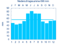
Diagram of precipitation mean values in Unterschwaningen for the period from 1961 to 1990


The average annual rainfall in Unterschwaningen is 698 mm.
history
Until the 19th century
The area around Unterschwaningen was already settled in the Neolithic Age, as is evident from finds from around 5600 BC. Prove. From 90 AD the area was occupied by the Romans , who left behind a wooden fort with a camp village, an estate and paved roads. During this time some of them probably founded Unterschwaningen. The name has nothing to do with a swan , as one might suspect based on the heraldic animal . Nor does it come from the Old English word "swan", which means young man, servant or shepherd, but probably from Sweno , the ancestor of a Frankish knightly family. An Alemannic document from 920 AD reports a place called Sweininga, which was in this area. In a document from 1053, "Sweiningen" is mentioned for the first time, which could mean both Unter- and Oberschwaningen. It speaks of Heinrich Sweininga, whose knightly family owned a moated castle and Unterschwaningen. The first document that can be assigned to Unterschwaningen comes from the year 1242.
During the rule of the Sweiningers, the first church in Unterschwaningen was consecrated in 1388 by a bishop from Eichstätt .
With the death of Hans von Sweiningen in 1455, the noble family of Sweiningen died out. As early as 1429, however, Conrad von Sweiningen sold the properties of Unterschwaningen to his brother-in-law Conrad von Holzingen. In the following decades the estate changed hands several times. In 1487 Sigmund von Holzingen sold the manor to his son-in-law Hans von Gundolsheim, who transferred it to the Margrave of Ansbach as a fief in 1511 . This was the first time the Ansbach margraves came into contact with Unterschwaningen. In 1517 the knight Ernst von Rechenberg received the castle and estate. In 1543, Unterschwaningen was converted to the Protestant faith by the Reformation . Since the last owner, Conrad von Rechenberg, died childless in 1583, the properties reverted to the feudal lords . Now Unterschwaningen was again in the direct area of responsibility of Margrave Georg Friedrich , who awarded the court of Unterschwaningen in 1599 the municipal coat of arms, which has been preserved to this day .
Under the rule of Margrave Joachim Ernst , the war bishop and privy councilor Johann Philipp Fuchs von Bimbach acquired the Unterschwaningen fief with all rights in 1603 . However, it was a buy-out, the old moated castle had become dilapidated, unsightly and out of fashion. The new owner was wealthy and was able to hire the builder Blasius Berwart the Elder to build a new castle on the same spot . J. win. When the fortified castle was completed in 1620, its owner could have looked forward to it, but he had other plans.


So he joined the army of Christian IV of Denmark during the Thirty Years War . He was from the German for this betrayal Emperor Ferdinand II. To outlawry made and outlaws explained. In August 1626 the Danish army was defeated at Lutter am Barenberge by the combined troops of Tilly and Wallenstein . Johann Philipp Fuchs von Bimbach was killed as a Danish general on August 27, 1626 .
Now the property of the outlaw fell to the emperor . This handed over the castle and property of the deceased to his Catholic cousin Hans Karl von Bimbach. In 1628 he had the Catholic faith reintroduced. But soon afterwards his reign ended. Financially settled, he handed over Unterschwaningen to the Margrave of Ansbach in 1630. On March 7, 1630, Wendelin Zahner was reintroduced as an evangelical clergyman. After his death in 1632 the pastor's position remained vacant due to the turmoil of the war. In autumn 1634, after the battle of Nördlingen, the place was almost completely devastated. Besides the castle, only four houses were spared. Since the early 1640s, the place became a refuge for numerous religious refugees ( exiles ) from Austria , who had to give way to the counter-reformation there and found a new home in Franconia .
Now it was long quiet about Unterschwaningen. Only when the Margravine Christiane Charlotte gave her life to the Hereditary Prince Karl Wilhelm Friedrich at the Ansbachian Margrave Court in 1712 did the stagnation come to an end. Out of joy at this birth, the margrave gave his wife the castle for life. For her, however, the castle was too old-fashioned, uncomfortable and sober. Above all, the dainty gardens that were fashionable right now were missing. So she commissioned the chief construction director Carl Friedrich von Zocha to lead the renovation. The new castle was completed around 1719. To the west of the old castle, a multi-wing building complex in the style of French Renaissance architecture was built , which was mainly used as a farm building .
In May 1729, their only son, Karl Wilhelm Friedrich, married Princess Friederike Luise von Prussia, two years younger than her, at the age of 17 . Born in Berlin , she was the daughter of Friedrich Wilhelm I , who was also known as the soldier king. On April 8, 1733, Friederike Luise gave life to the Hereditary Prince Karl Friedrich August and just one day later was given the position of Unterschwaningen as a fiefdom. Energetic and artful, she furnished the gray castle with rococo stunts . Thereafter, a pleasure garden and park extended on the southeast side, which was laid out according to the French pattern . She also had an artificial watercourse built that connected to the garden and ended after a length of about one kilometer behind a curved bridge. At the southeast end the channel was widened to a small lake, in the middle of which an island with a glass pavilion rose.


On May 8th, 1737 the eldest son of the Margravine Friederike Luise died. The Margrave and the Ansbach court society blamed her for it, so she was exiled to Unterschwaningen under the leadership of Marshal von Seckendorff .
At the request of the margravine, the dilapidated Gothic chapel was to be replaced by a new church . The highest point in Unterschwaningen was found to be a suitable building site. After the previous owner had given way, the foundation stone was laid in September 1738. The construction, which was led by master builder Leopoldo Retti , proceeded quickly. The nave was already completed in 1739 . In the meantime the first two Silesian Wars broke out against Austria and work on the tower was delayed. Therefore, the consecration could only be celebrated on May 9, 1743. In 1753, a parsonage in the Baroque style was completed on the site of a ruinous building .
The margrave died in 1757, but Friederike Luise remained in Unterschwaningen until she died of pneumonia on February 4, 1784 . In June of the same year, the last Margrave Christian Friedrich Karl Alexander gave the palace and office to his wife Friederika Carolina . The ailing margravine died on February 18, 1791 at the age of 55. The margrave sold the property to his cousin, King Friedrich Wilhelm III. of Prussia before emigrating to England with his lover, Lady Craven .
The halls of the palace remained unused, the large library , whose works Friederike Luise had collected, was given to the University of Erlangen , and other valuable items were brought to the Ansbach residence. What was left was stolen or destroyed.
But the castle was to have noble residents again for a short time. In 1795, 63 refugees who were fleeing the turmoil of the French Revolution moved into the rooms. It was not until the Peace of Lunéville in 1801 that peace returned to the country. In 1802 the refugees and the Prince of Oettingen-Wallerstein , who had also sought protection from the French troops, returned to their homeland.


Unterschwaningen was in the Fraisch district of the Ansbach Oberamt Wassertrüdingen . The village and community rulership as well as the manorial rule was exercised by the Ansbach administrative office Schwaningen . Towards the end of the 18th century there was 77 Property (1 mill 1 Ziegelhuette, 1 Schmiedgut, 1 economy, 4 yards, 7/2 yards, 10 Sölden goods , 2 Sölden goods Hafner right 1 Söldengut with baking right 1 Söldengut of bread and other spirits focal law, 9 Söldengütlein, 2 half Söldengütlein, 1 Gütlein, 26 houses, 2 Häuslein, 1 bag house , 4/2 houses, 2 Halbhäuslein. Good 1 was free intrinsically ). In addition to these properties, there was also the old and the new castle with the court gardener's house, school house, game master’s house and two other semi-detached houses, the church, a rectory and two community pastors' houses. According to this there were 67 subject families. From 1797 to 1808 the place was subordinate to the Justice and Chamber Office Wassertrüdingen .
In 1806 Franconia and with it all of the Hohenzollern possessions there fell to the new Kingdom of Bavaria . Since the kingdom refused to pay for the further maintenance of the castle, all properties with the exception of the forest, park and castle were auctioned in 1807. After unsuccessful attempts to set up a granary and a royal rent office in parts of the castle , the remaining buildings were sold in 1811. The new owner, the secretary Wirtmann from Ansbach , had the ball building and the connecting wings of the horseshoe-shaped corner pavilions demolished. The four corner pavilions were suitable for residential purposes and thus escaped destruction. The ornate parks became meadows and fields, the canal served as a water reservoir for a nearby mill. A brewery, school, kindergarten and community office later moved into the former farm buildings.
As a result of the municipal edict, the tax district of Unterschwaningen was formed in 1809 , to which Dennenlohe and Oberschwaningen belonged. At the same time, the rural communities of Dennenlohe and Unterschwaningen with Oberschwaningen were created. With the second community edict (1818) Oberschwaningen became an independent rural community. The municipality of Unterschwaningen was under the administration and jurisdiction of the district court Wassertrüdingen and the financial administration of the Rentamt Wassertrüdingen ( renamed in 1919 to Finanzamt Wassertrüdingen , 1932–1973 Finanzamt Gunzenhausen , since 1973 Ansbach tax office ). The jurisdiction remained with the district court Wassertrüdingen until 1879, from 1879 to 1956 the district court Wassertrüdingen was responsible, from 1956 to 1970 the district court Gunzenhausen and from 1970 to 1973 the district court Dinkelsbühl , which has been a branch of the district court Ansbach since 1973 . The administration was taken over by the newly created Dinkelsbühl district office in 1862 (renamed the Dinkelsbühl district in 1938 ). When the Dinkelsbühl district was dissolved in 1972, Unterschwaningen came to the Ansbach district. In 1961 the municipality had an area of 5,458 km².
20th century
In the years from 1969 to 1991 land consolidation measures took place.
Incorporations
On April 1, 1971, the previously independent communities of Dennenlohe and Kröttenbach were incorporated. Oberschwaningen was added on May 1, 1978.
Population development
In the period from 1988 to 2018, the population increased from 849 to 877 inhabitants or by 3.3%.
Community of Unterschwaningen
| year | 1979 | 1987 | 1991 | 1995 | 2003 | 2005 | 2010 | 2011 | 2012 | 2013 | 2014 | 2015 | 2016 | 2017 |
|---|---|---|---|---|---|---|---|---|---|---|---|---|---|---|
| Residents | 843 | 858 | 854 | 873 | 923 | 893 | 864 | 864 | 876 | 867 | 880 | 870 | 872 | 873 |
| Houses | 231 | 278 | 279 | 282 | 283 | 287 | 292 | 295 | ||||||
| source |
District of Unterschwaningen
| year | 1818 | 1840 | 1852 | 1855 | 1861 | 1867 | 1871 | 1875 | 1880 | 1885 | 1890 | 1895 | 1900 | 1905 | 1910 | 1919 | 1925 | 1933 | 1939 | 1946 | 1950 | 1952 | 1961 | 1970 | 1987 |
|---|---|---|---|---|---|---|---|---|---|---|---|---|---|---|---|---|---|---|---|---|---|---|---|---|---|
| Residents | 601 | 601 | 532 | 516 | 520 | 536 | 543 | 528 | 542 | 545 | 544 | 535 | 532 | 530 | 552 | 550 | 546 | 490 | 444 | 673 | 630 | 607 | 522 | 521 | 464 |
| Houses | 104 | 110 | 121 | 123 | 123 | 124 | 119 | 116 | 132 | ||||||||||||||||
| source |


religion
80% of the inhabitants of Unterschwaningen are Protestant and 14% Catholic. The Protestant parishes of Ober- and Unterschwaningen belong to the Wassertrüdingen deanery in the Ansbach-Würzburg parish of the Evangelical Lutheran Church in Bavaria . The Catholics in Unterschwaningen belong to the parish of the Holy Spirit in Wassertrüdingen , five kilometers to the south, Herrieden dean's office , Eichstätt diocese .
politics
Municipal council
After the local election on March 15, 2020 , the local council had eight members. The turnout was 71.88%. The choice brought the following result:
| Free group of voters | 8 seats |
Another member and chairman of the municipal council is the mayor.
mayor
Markus Bauer has been mayor since 2020.
badges and flags
|
|
Blazon : " Square of silver and black, covered with a striding, red armored silver swan with outstretched wings."
Red-white-black municipal flag |
|
Crest Reason: The Swan is talking for the place name. The place was the aristocratic seat of the Lords of Schwaningen, who are attested from 1163 to 1429. The Margraves of Brandenburg had been feudal lords since 1482. The Zollernvierung of silver and black reminds of this . Margrave Georg Friedrich von Brandenburg awarded the coat of arms to the Schwaningen detention court in 1599 . It is one of the few village coats of arms in the Franconian principalities. King Maximilian II approved the re-acceptance of the coat of arms in 1860 after rural communities were prohibited from using coats of arms seals in 1818. |
Architectural monuments
dialect
The spoken dialect is East Franconian with Swabian touches, as the place is in the transition zone of both dialects .
traffic
The national road 2221 runs west of Unterschwaningen and leads to Dennenlohe over after Großenried or to Altentrüdingen over after Wassertruedingen . The state road 2219 runs north from Unterschwaningen and leads to upper Schwaningen and Cronheim over to the federal highway 466 . The district road AN 47 leads to Lentersheim , the district road AN 61 to Obermögersheim .
Unterschwaningen has a stop on the Nördlingen – Gunzenhausen railway line . Special train trips for the Bavarian Railway Museum take place here in the summer months .
The Unterschwaningen air sports area is a small airfield for microlight aircraft.
Personalities
- Hans Keesebrod (1537–1616), important Renaissance master builder, mayor and reformer, builder a. a. of the market-wide town hall, was born in Unterschwaningen.
- Johann Wolfgang Frank (1644 – around 1710), born in Unterschwaningen, Kapellmeister in Ansbach, cantor in Hamburg and an important composer. Composed the first German opera "Die drey Töchter Cecrop" (1679)
- Otmar Wassermann (* 1934), toxicologist
literature
- Johann Kaspar Bundschuh : Unterschwaningen . In: Geographical Statistical-Topographical Lexicon of Franconia . tape 5 : S-U . Verlag der Stettinische Buchhandlung, Ulm 1802, DNB 790364328 , OCLC 833753112 , Sp. 647-648 ( digitized version ).
- August Gebeßler : City and district of Dinkelsbühl (= Bavarian art monuments . Volume 15 ). Deutscher Kunstverlag, Munich 1962, DNB 451450930 , p. 201-206 .
- Georg Muck: History of Heilsbronn Monastery from prehistoric times to modern times . tape 2 . For Kunstreprod. Schmidt, Neustadt an der Aisch 1993, ISBN 3-923006-90-X , p. 521 (first edition: Beck, Nördlingen 1879).
- Teresa Neumeyer: Dinkelsbühl: the former district (= Historical Atlas of Bavaria, part of Franconia . I, 40). Michael Laßleben, Kallmünz 2018, ISBN 978-3-7696-6562-8 .
- Wolf-Armin von Reitzenstein : Lexicon of Franconian place names. Origin and meaning . Upper Franconia, Middle Franconia, Lower Franconia. CH Beck, Munich 2009, ISBN 978-3-406-59131-0 , p. 227 .
- Gottfried Stieber: Schwaningen . In: Historical and topographical news from the Principality of Brandenburg-Onolzbach . Johann Jacob Enderes, Schwabach 1761, p. 742-753 ( digitized version ).
Web links
- Map of the community of Unterschwaningen in the Bavaria Atlas
- Unterschwaningen in the Topographia Franconiae of the University of Würzburg , accessed on September 17, 2019.
- Unterschwaningen: Official statistics of the LfStat
- Unterschwaningen Castle
Individual evidence
- ↑ "Data 2" sheet, Statistical Report A1200C 202041 Population of the municipalities, districts and administrative districts 1st quarter 2020 (population based on the 2011 census) ( help ).
- ^ Community of Unterschwaningen in the local database of the Bayerische Landesbibliothek Online . Bayerische Staatsbibliothek, accessed on September 17, 2019.
- ^ History of Unterschwaningen
- ↑ W.-A. v. Reitzenstein, p. 227.
- ↑ Eberhard Krauss: Exulanten im Evang.-Luth. Deanery Wassertrüdingen (sources and research on Franconian family history, 28) . GFF, Nuremberg 2014, ISBN 978-3-929865-61-5 .
- ↑ On their arrival there on June 25, 1784, Johann Christoph Zenker wrote a jubilee song .
- ^ T. Neumeyer, p. 468.
- ^ Johann Bernhard Fischer : Unterschwaningen . In: Statistical and topographical description of the Burggraftum Nürnberg, below the mountain, or the Principality of Brandenburg-Anspach. Second part. Containing the economic, statistical and moral condition of these countries according to the fifteen upper offices . Benedict Friedrich Haueisen, Ansbach 1790, p. 385 ( digitized version ).
- ↑ a b T. Neumeyer, p. 580.
- ^ T. Neumeyer, p. 534.
- ↑ T. Neumeyer, pp. 540f.
- ^ Address and statistical manual for the Rezatkreis in the Kingdom of Baiern . Buchdruckerei Chancellery, Ansbach 1820, p. 72 ( digitized version ).
- ↑ a b Bavarian State Statistical Office (ed.): Official city directory for Bavaria, territorial status on October 1, 1964 with statistical information from the 1961 census . Issue 260 of the articles on Bavaria's statistics. Munich 1964, DNB 453660959 , Section II, Sp. 764 ( digitized version ).
- ^ Wilhelm Volkert (ed.): Handbook of Bavarian offices, communities and courts 1799–1980 . CH Beck, Munich 1983, ISBN 3-406-09669-7 , p. 448 .
- ^ Federal Statistical Office (ed.): Historical municipality directory for the Federal Republic of Germany. Name, border and key number changes in municipalities, counties and administrative districts from May 27, 1970 to December 31, 1982 . W. Kohlhammer, Stuttgart / Mainz 1983, ISBN 3-17-003263-1 , p. 707 f .
- ↑ a b Only inhabited houses are given. In 1818 these were designated as fireplaces , in 1840 as houses , and from 1871 to 2017 as residential buildings.
- ↑ a b Bavarian State Office for Statistics and Data Processing (Ed.): Official local directory for Bavaria, territorial status: May 25, 1987 . Issue 450 of the articles on Bavaria's statistics. Munich November 1991, DNB 94240937X , p. 331 ( digitized version ).
- ↑ a b c d e f g h i Unterschwaningen: Official statistics of the LfStat
- ↑ Alphabetical index of all the localities contained in the Rezatkkreis according to its constitution by the newest organization: with indication of a. the tax districts, b. Judicial Districts, c. Rent offices in which they are located, then several other statistical notes . Ansbach 1818, p. 96 ( digitized version ).
- ↑ Eduard Vetter (Ed.): Statistical handbook and address book of Middle Franconia in the Kingdom of Bavaria . Self-published, Ansbach 1846, p. 255 ( digitized version ).
- ↑ a b c d e f g h i j k Bavarian State Statistical Office (Hrsg.): Historical municipality directory: The population of the municipalities of Bavaria from 1840 to 1952 (= contributions to Statistics Bavaria . Issue 192). Munich 1954, DNB 451478568 , p. 168 , urn : nbn: de: bvb: 12-bsb00066439-3 ( digitized ).
- ^ Joseph Heyberger, Chr. Schmitt, v. Wachter: Topographical-statistical manual of the Kingdom of Bavaria with an alphabetical local dictionary . In: K. Bayer. Statistical Bureau (Ed.): Bavaria. Regional and folklore of the Kingdom of Bavaria . tape 5 . Literary and artistic establishment of the JG Cotta'schen Buchhandlung, Munich 1867, Sp. 1006 , urn : nbn: de: bvb: 12-bsb10374496-4 ( digitized version ). Unterschwaningen: 519 inhabitants; Railway keeper's house: 1 E.
- ↑ Kgl. Statistisches Bureau (Ed.): Directory of the municipalities of the Kingdom of Bavaria according to the status of the population in December 1867 . XXI. Issue of the contributions to the statistics of the Kingdom of Bavaria. Ackermann, Munich 1869, p. 157 ( digitized version ).
- ↑ Kgl. Statistical Bureau (ed.): Complete list of localities of the Kingdom of Bavaria. According to districts, administrative districts, court districts and municipalities, including parish, school and post office affiliation ... with an alphabetical general register containing the population according to the results of the census of December 1, 1875 . Adolf Ackermann, Munich 1877, 2nd section (population figures from 1871, cattle figures from 1873), Sp. 1172 , urn : nbn: de: bvb: 12-bsb00052489-4 ( digitized version ).
- ↑ K. Bayer. Statistical Bureau (ed.): Community directory for the Kingdom of Bavaria. Manufactured due to the new organization of government districts, district offices and judicial districts. Addendum to issue 36 of the articles on Bavaria's statistics. Munich 1879, p. 61 ( digitized version ).
- ↑ K. Bayer. Statistical Bureau (ed.): Community directory for the Kingdom of Bavaria. Results of the census of December 1, 1880. Issue 35 of the articles on Bavaria's statistics. Munich 1882, p. 176 ( digitized version ).
- ↑ K. Bayer. Statistical Bureau (Ed.): Localities directory of the Kingdom of Bavaria. According to government districts, administrative districts, ... then with an alphabetical register of locations, including the property and the responsible administrative district for each location. LIV. Issue of the contributions to the statistics of the Kingdom of Bavaria. Munich 1888, Section III, Sp. 1104 ( digitized version ).
- ↑ K. Bayer. Statistical Bureau (Ed.): Directory of localities of the Kingdom of Bavaria, with alphabetical register of places . LXV. Issue of the contributions to the statistics of the Kingdom of Bavaria. Munich 1904, Section II, Sp. 1170 ( digitized version ).
- ↑ Bavarian State Statistical Office (ed.): Localities directory for the Free State of Bavaria according to the census of June 16, 1925 and the territorial status of January 1, 1928 . Issue 109 of the articles on Bavaria's statistics. Munich 1928, Section II, Sp. 1208 ( digitized version ).
- ↑ Bavarian State Statistical Office (ed.): Official place directory for Bavaria - edited on the basis of the census of September 13, 1950 . Issue 169 of the articles on Bavaria's statistics. Munich 1952, DNB 453660975 , Section II, Sp. 1040 ( digitized version ).
- ^ Bavarian State Statistical Office (ed.): Official place directory for Bavaria . Issue 335 of the articles on Bavaria's statistics. Munich 1973, DNB 740801384 , p. 171 ( digitized version ).
- ↑ census database
- ^ Entry on the coat of arms of Unterschwaningen in the database of the House of Bavarian History
- ↑ Unterschwaningen. In: Kommunalflaggen.eu. Retrieved July 15, 2020 .

Adelshofen | Arberg | Aurach | Bechhofen | Bruckberg | Book at the forest | Burgoberbach | Burk | Colmberg | Dentlein am Forst | Diebach | Dietenhofen | Dinkelsbühl | Dombühl | Dürrwangen | Ehingen | Feuchtwangen | Flachslanden | Gebsattel | Gerolfingen | Geslau | Heilsbronn | Herrieden | Insingen | Langfurth | Lehrberg | Leutershausen | Lichtenau | Merkendorf | Mitteleschenbach | Mönchsroth | Neuendettelsau | Neusitz | Oberdachstetten | Ohrbach | Ornbau | Petersaurach | Röckingen | Rothenburg ob der Tauber | Rügland | Saxony near Ansbach | Schillingsfürst | Schnelldorf | Schopfloch | Steinsfeld | Unterschwaningen | Wassertrüdingen | Weidenbach | Weihenzell | Weiltingen | Wettringen | Wieseth | Wilburgstetten | Windelsbach | Windsbach | Wittelshofen | Wolframs-Eschenbach | Wörnitz
Unregulated areas:
Lower Forest