
Market wide
| coat of arms | Germany map | |
|---|---|---|

|
Coordinates: 49 ° 40 ' N , 10 ° 9' E |
|
| Basic data | ||
| State : | Bavaria | |
| Administrative region : | Lower Franconia | |
| County : | Kitzingen | |
| Management Community : | Market wide | |
| Height : | 191 m above sea level NHN | |
| Area : | 20.16 km 2 | |
| Residents: | 3953 (Dec. 31, 2019) | |
| Population density : | 196 inhabitants per km 2 | |
| Postal code : | 97340 | |
| Area code : | 09332 | |
| License plate : | KT | |
| Community key : | 09 6 75 147 | |
| LOCODE : | DE MKT | |
| City structure: | 2 districts | |
City administration address : |
Marktstrasse 4 97340 Marktbreit |
|
| Website : | ||
| Mayor : | Harald Kopp ( SPD ) | |
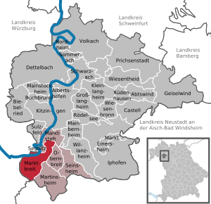
| Location of the town of Marktbreit in the Kitzingen district | ||
  |
||


Marktbreit am Main is a town in the Lower Franconian district of Kitzingen . It is located in the state of Bavaria and is the seat of the Marktbreit administrative association .
geography
Geographical location
The city is located at the southernmost point of the Main Triangle on the left bank of the Main .
City structure
The two districts of the municipality:
- Gnodstadt
- Market wide
Neighboring communities
Neighboring communities are (clockwise from the north): Marktsteft , Obernbreit , Martinsheim , Oberickelsheim , Ochsenfurt , Frickenhausen am Main and Segnitz .
Natural location
The town of Marktbreit and its district have shares in two natural areas. The town of Marktbreit lies in the valley of the Breitbach, which is deeply carved into the shell limestone and flows into the Main. Another brook flowing from Gnodstadt also flows into the Main in the former western moat. The few arable land of Marktbreits are in the east and west of the town with its rather small area on the high plateau of the Franconian Gäuland. There is about 3 km southwest of the traditional large village Gnodstadt, whose extensive fields belong to the Ochsenfurt-Uffenheimer Gäufläche with its flat undulating relief and extremely fertile loess loam soils.

The Main Triangle is one of the warmest and driest regions in Franconia . This climate is particularly favorable for the cultivation of wine , fruit and vegetables. Marktbreit is hit by the floods of the Main several times a century. This is documented by the high water marks that are notched on the town hall of Marktbreit and on the Baroque palace Zur Groe opposite.
history
Until the 19th century
In 1985, the Roman camp Marktbreit was discovered during a flight by aerial photo archaeologist Otto Braasch . Marktbreit was mentioned for the first time as "broite inferior", that is, Unter- or Niedernbreit, in a document from Count zu Castell in 1266. In the later Middle Ages, Marktbreit was called Unterbreit or Niedernbreit or Breit and thus differed from neighboring Obernbreit. The name Marktbreit was mentioned as early as 1567. Presumably there was a settlement at the mouth of the Breitbach a few hundred years earlier , but little is known about it. In 1557 King Ferdinand I granted the local lord and Frankish imperial knight Georg Ludwig von Seinsheim (1514–1591) market rights . The name change to Marktbreit is probably due to this. The small town began to flourish under the rule of Georg Ludwig von Seinsheim. In 1618 there were 268 households in Marktbreit. In 1643 it was looted and fell victim to a plague epidemic that claimed 800 lives. The previously so flourishing market town on the Main became deserted. Under the rule of the Schwarzenberg family, who was related to the Seinsheimers, since 1643, the place developed into one of the most important trading locations on the Main at the beginning of the 18th century, as evidenced by the Alte Kranen at the harbor. Marktbreit was able to benefit primarily from the favorable geographical location at the southernmost point of the Main and thus the shortest connection to the Danube. In 1806 the place became part of the Kingdom of Bavaria and was then added to the Grand Duchy of Würzburg for a few years . In 1814 he finally came to Bavaria and received city rights in 1819 . With the development of Franconia by the railroad from the middle of the 19th century, the importance of shipping on the Main and of haulage between the Main and Danube declined significantly, and with it the importance of smaller trading locations such as Marktbreit. Many merchants left the city.
From 1900
In the 3rd Reich in 1938 there were massive attacks against residents of the Jewish faith and the synagogue was desecrated. Before he became Gauleiter and District President of Lower Franconia ("Mainfranken") in Würzburg, the fanatical Nazi and anti-Semite Otto Hellmuth , who was born in Markt Einersheim, lived and worked as a dentist in Marktbreit.
Until the 1980s, Marktbreit was a sub-center for the surrounding area, where you could get (almost) everything you needed. For some time now, the retail trade in the city center has declined significantly - not least in the formerly lively Schustergasse.
Marktbreit was and is a school town. In contrast to the neighboring, much larger Ochsenfurt, there is a high school in Marktbreit, which is attended not least by the children from Ochsenfurt and the Ochsenfurt Gau.
Incorporations
With the territorial reform that came into force on May 1, 1978, Gnodstadt , about four kilometers away , until then part of the Würzburg district , with around 700 inhabitants, became a district of Marktbreit.
politics
City council
In the 2014 and 2020 local elections , 16 city councilors were elected. They are distributed among the individual parties and groups as follows:
| Party / list | Seats 2014 | Seats 2020 |
| CSU | 4th | 4th |
| SPD | 5 | 4th |
| Green / broad citizen | 1 | 0 |
| Free voter group Gnodstadt | 4th | 5 |
| Free voters e. V. | 2 | 3 |
mayor
Mayor has been Harald Kopp ( SPD ) since May 1, 2020 , who was elected in the runoff election on March 29, 2020 against Sven Biebelriether (Free voter group Gnodstadt) with 62.5% of the votes. Six years earlier, on March 16, 2014, Harald Kopp lost 49.05% of the votes to the incumbent Erich Hegwein ( CSU ), who was re-elected as first mayor with 50.95% of the votes cast .
Town twinning
-
 France : Fléac near the south-west French city of Angoulême
-
 Germany : Benshausen , part of the city of Zella-Mehlis in the district of Schmalkalden-Meiningen
-
 Czech Republic : City partnership with Asch since 2012
coat of arms
|
|
Blazon : "Inside a golden border over a blue shield base, in it a silver wave bar, in blue a silver armored knight with a helmet and belted short sword, looking over it, the left arm lying over it, with the right foot on a green, two-winged legless dragon beneath himStanding with his head stretched up and a horseshoe tail twisted into a bow and thrusting a golden flagged lanceinto the flaming gold, open jaws, on the silver flag waving to the left, in two bends down and ending in twosides, aheraldic shield split five times by blue and silver. " |
| Founding of the coat of arms: At the request of Georg Ludwig von Seinsheim, Emperor Ferdinand I granted the place not only market rights but also the right to use a coat of arms and a seal. In 1562 the place was also granted tax exemption. On the coat of arms you can see a dragon-slaying knight in silver armor. This is Saint George , who, as the symbolic protector of Marktbreit, bears the coat of arms of the local lord Georg Ludwig von Seinsheim in the flag . He had fortified the place with walls, towers and four gates. The Lords of Seinsheim had rulership since 1457 and have been in the former village of Niedernbreit since 1409. The wave bar is an indication of the location of the city on the Main. Today's coat of arms, which has been in use since 1557, is identical to that on the oldest seals and has not changed in the centuries that followed. |
| Coat of arms of Gnodstadt | |
 |
Blazon : "The silver clad apostles Peter (right) and Paul, the first raised his right, in the left a key, the latter a sword in the left, the right raised with a cross as a blessing." |
| Justification for the coat of arms: The two apostles have been referring to the town's two church patrons since the Thirty Years' War. |
Culture and sights
Museums
- The Malerwinkelhaus museum is located on the left in front of the city gate. The living conditions of women of different social classes and denominations who were born between the last quarter of the 19th and the first quarter of the 20th century are presented realistically. Furthermore, explanations are given on the structure and marching performance of the Roman cohorts and Centuries . Regular special exhibitions on cultural and historical topics complement the permanent exhibitions.
- The Alois Alzheimer memorial and conference center with four exhibition rooms has been located at Ochsenfurter Straße 15a since 1995. As a memorial plaque indicates, Alois Alzheimer was born in this house on June 14, 1864 . It is accessible after registering at the city information.
Buildings


- The historic old town of Marktbreits is protected as an ensemble.
- Freight crane from 1784: The old crane was used to transfer goods between river and land transport. On the east side, a walled-in icebreaker protects against ice and flooding . The turnover of goods flourished because of the market rights that the village had received in 1557 and the favorable transport links (Main).
- Warehouse from 1745, destroyed in 1945, restored in 2003.
- Renaissance town hall with council chamber and connected city gate (built 1579–1581 by Hans Keesebrod on behalf of Georg Ludwig von Seinsheim ).
- Seinsheim Castle , built from 1585 as the residence of the wife of Georg Ludwig von Seinsheim
- Evangelical Church of St. Nikolai (14th century, modified several times)
- Catholic Church of St. Ludwig (19th century)
- Trading houses in the Würzburg Baroque style, built in 1719 and 1725 and the Malerwinkelhaus from around 1774
- Hotel Lowen. It is the second oldest inn in Bavaria and is located on the market square. It was first mentioned in a document in 1450. The half-timbering dates from the 18th century. The inn used to be the Fürstlich Schwarzenbergische Herberge.
- St. Peter and Paul , Gnodstadt, 13th century, unique bell
- Gnodstadt toll pyramid
- The city wall is partially built with residential houses. Many round defense towers are still preserved and some were used or inhabited until the middle of the 20th century. The local walling dates from the 16th century. There used to be four gates, of which the main gate, built in 1600, which was destroyed in the war in 1945 and renewed in 1946/47, has been preserved. A circular path leads alternately outside and inside the city wall.
- In front of the old town, the two suburbs Buheleiten-Vorstadt and Steigvorstadt were laid out in the 18th century , and at the beginning of the 19th century a third settlement was added with Mainstrasse . All three settlements differ in their specific appearance.
- Former Roman camp on the Kapellenberg in Marktbreit : aerial photographs revealed discoloration of the soil in 1985 and, during excavations, evidence of a large double legion camp was discovered. It was the easternmost Roman camp in free Germania. Today only a Roman trail with eight information boards reminds of it. Visible traces can no longer be seen after the excavation area has been filled in. In the Museum Malerwinkelhaus there are documentations on life in the legions.
Memorials
The former synagogue of the Jewish community of Marktbreit was built in 1717. In 1933, 127 Jews lived in Marktbreit. The interior of the synagogue was destroyed during the Reichspogromnacht on November 10, 1938. The facade and the entrance portal were preserved and renovated. The left memorial plaque commemorates the Jews from Marktbreit who died in the First World War. The right plaque lists the names of the 90 fellow citizens of the community who were murdered during the Shoah and keeps the memory of them alive. Only one Jewish woman returned to Marktbreit after the National Socialist era.
The former Moritzkapelle on the Römerberg was a pilgrimage church for the residents of Marktbreit in the Middle Ages. After the decline during the Reformation, the church was rebuilt in the 20th century. The new chapel is used today as a war memorial chapel and memorial for those who fell in the world wars in the Kitzingen district.
Architectural monuments
Say
The Lindworm
St. George is the town patron of Marktbreit. A lindworm is said to have once lived in the moat of Marktbreit and claimed human sacrifice every day . At some point the dragon became more and more greedy and ate the inhabitants en masse. Then a knight heard of the dragon and went to meet the dragon. The knight saw the dragon and stabbed the animal with his lance. The dragon was finally dead and the population received pieces of dragon meat.
The Waterman
Aquarius is said to live in the Main at Marktbreit . But it is usually invisible and you don't even notice it. But if a child gets too close to the river, Aquarius pulls them down. Then he presents himself as a two-headed being.
Economy and Infrastructure
traffic
Marktbreit has a train station on the Treuchtlingen – Würzburg railway line . It has a direct connection to the A 7 motorway (exit 104). In addition, the place is on the state road 2271 , which connects the federal road 8 (5 km east) and the federal road 13 (5 km west). Marktbreit lies on the Main as a connection to a transcontinental waterway (Rhine-Main-Danube). At the ports of Marktbreits, there are landing and transshipment options for motorized goods ships and push convoys up to 135 meters in length and 11.45 meters in width, as well as for river cruise ships, small vehicles and muscle-powered pleasure craft at specially adapted berths.

In addition to the Main Bridge Marktbreit , over which the Federal Motorway 7 runs, Marktbreit is connected to the Segnitz opposite via the Main Bridge Segnitz . Originally there was a ferry connection there .
Viticulture
Marktbreit is a small wine-growing town in the Franconian wine-growing region . The vineyards are located in the northeast of the town towards Marktsteft / Michelfeld, the wine has been marketed under the name Marktbreiter Sonnenberg since the 1970s. MARKTBREIT is part of the region Main south until 2017, the wineries in area were Maindreieck summarized. The limestone soils around Marktbreit are also suitable for growing wine, as is the location in the Main Triangle, which is one of the warmest areas in Germany.
The people around Marktbreit have been viticulture since the early Middle Ages . The Franconian settlers probably brought the vine to the Main in the 7th century. In the Middle Ages, Franconia was one of the largest wine-growing regions in Central Europe. The people mostly operated part-time viticulture for self-sufficiency , at the same time export centers were already emerging, especially along the Main. In the 18th century Marktbreit was an important wine trading town, and it was here that the conditions for quality winegrowing were first written down.
Franconian viticulture experienced a major decline in the 19th century. Above all, locations with less favorable climatic conditions were completely abandoned. In addition, the emergence of pests such as phylloxera made cultivation difficult . The Franconian wine-growing region was not able to consolidate again until the second half of the 20th century. The use of fertilizers and improved cultivation methods had contributed to this, as had the organization in cooperatives and the land consolidation of the 1970s.
Today viticulture in Marktbreit only plays a subordinate economic role. However, in addition to the preserved old town, the wine landscape also attracts tourists. The focus of the festival calendar is the market-wide wine festival in the city center, which takes place at the end of July. Several wineries are located in the village, but the vineyards around Marktbreit are predominantly cultivated by foreign winegrowers.
| Vineyard | Size 1993 | Size 2019 | Compass direction | Slope | Main grape varieties | Great location |
|---|---|---|---|---|---|---|
| Sonnenberg | 20 ha | 21 ha | South, southwest | 30-35% | Müller-Thurgau | Kitzinger Councilor |
education
There are the following schools in Marktbreit:
- primary school
- Middle school (since the school year 2010/2011 in the school association “Maindreieck” with the other middle school locations Ochsenfurt and Gaukönigshofen.)
- Leo-Weismantel-Realschule Marktbreit (this private school has existed since 1849)
- Bildungswerk Marktbreit (private secondary school since 1984, partner school of the Leo-Weismantel secondary school)
- high school
Personalities
sons and daughters of the town


- Laurentius Flor (also Florus, 1614–1680), pastor, theological writer
- Daniel Keyser (1631–1673), professor of law, writer
- Johann Heinrich Seyfried (around 1640–1715), court chamber councilor, writer
- Johann Leonhard Lenz (1652–1737), teacher, educational writer
- Georg Christian Joannis (1658–1735), Protestant theologian and historian
- Johann Samuel Schoder (1660 – around 1740), doctor, writer, historian
- Lorenz Wilhelm Cranz (also Crantz, 1674–1742), pastor, song poet, prayer book author
- Georg Günther (1709–1791), businessman
- Franziska Barbara Reiz (1715–1785), poet
- Georg Albrecht Weinrich (1755–1814), also Georg Albert Weinrich, physician
- Georg Franz Hoffmann (1760–1826), botanist, lichenologist, mycologist and bryologist
- Johann Ernst Seidel (1765–1832), German-Danish State Councilor, Mayor of Glückstadt
- Johann Ernst Günther (1787–1852), mayor and member of the state parliament
- Christian Fischer (1823–1871), member of the Reichstag
- Christoph Husband (1835–1897), professor in Kaiserslautern, writer
- Bernhard Zippelius (1836–), pastor, historian, publicist
- Alois Alzheimer (1864-1915), neurologist and psychiatrist
- Jörg Geuder (1861–1935) teacher, poet, writer and language tutor.
- Rudolf Buttmann (1885–1947), lawyer, librarian, NSDAP politician
- Oekonomierat August Ziegler (1885–1937), oenologist, breeder of the Rieslaner grape, refiner of the Müller-Thurgau grape
- Wolf Justin Hartmann (1894–1969) adventurer, writer and officer in both world wars
- Ludwig Friedrich Barthel (1898–1962), Germanist, archivist, poet, narrator and essayist
- Gudrun Höhl (1918–2009), geographer
- Erwin Roth (1926-1998), psychologist
- Anneliese Lussert (1929–2006), poet
Personalities who worked across the market
- Georg Ludwig von Seinsheim (1514–1591), district colonel of the Franconian district, died in Marktbreit
- Hieronymus Florentinus Quehl (1694–1739), organist and composer
- Salomon Wohl (1818–1902), teacher and school founder, founded the Salomon Wohl'sche Institute in Marktbreit
- Leo Weismantel (1888–1964), writer and reform pedagogue, lived in Marktbreit between 1920 and 1933 and founded the "School of the People" here in 1928
- Otto Hellmuth (1896–1968), NSDAP politician (Gauleiter), district president of Mainfranken
- Walter Galuschka (1921–1967), SPD politician
- Simone Michel-von Dungern (* 1965), classical archaeologist, Michel has been heading the Museum Malerwinkelhaus since 2010
- Johannes Schmalzl (* 1965), District President in Stuttgart 2008–2016, grew up in Marktbreit
literature
- Hans Ambrosi, Bernhard Breuer: German Vinothek: Franconia. Guide to the vineyards, winegrowers and their kitchens . Herford 2 1993.
- Hans Bauer: Old and new coats of arms in the Kitzingen district . In: Yearbook of the district of Kitzingen 1980. In the spell of the Schwanberg . Kitzingen 1980. pp. 53-70.
- Johann Ludwig Klarmann: The Steigerwald in the past. A contribution to Franconian cultural studies . Gerolzhofen 2 1909.
- Johann Ludwig Klarmann, Karl Spiegel: Legends and sketches from the Steigerwald. Reprint of the 1912 edition . Neustadt an der Aisch 1982.
Web links
- Official website of the city of Marktbreit
- Entry on the coat of arms of Marktbreit in the database of the House of Bavarian History
Individual evidence
- ↑ "Data 2" sheet, Statistical Report A1200C 202041 Population of the municipalities, districts and administrative districts 1st quarter 2020 (population based on the 2011 census) ( help ).
- ↑ http://www.bayerische-landesbibliothek-online.de/orte/ortssuche_action.html ? Anzeige=voll&modus=automat&tempus=+20111114/163039&attr=OBJ&val= 1661
- ^ Museum Malerwinkelhaus Marktbreit (ed.): A look into the Renaissance. Georg Ludwig von Seinsheim and his time. Flyer for the exhibition from March 24, 2007-21. October 2007.
- ^ Federal Statistical Office (ed.): Historical municipality directory for the Federal Republic of Germany. Name, border and key number changes in municipalities, counties and administrative districts from May 27, 1970 to December 31, 1982 . W. Kohlhammer GmbH, Stuttgart / Mainz 1983, ISBN 3-17-003263-1 , p. 748 .
- ↑ http://www.marktbreit.info/wahlen/gw2014mbt.html
- ↑ List of City Councils 2020 , accessed on June 27, 2020
- ↑ http://www.marktbreit.info/wahlen/bw2014mbt.html Election 2014
- ^ Bauer, Hans: Old and new coats of arms in the district of Kitzingen . P. 61.
- ↑ Official website of the Malerwinkelhaus Museum
- ↑ Eckart Roloff and Karin Henke-Wendt: First testimonials from a pioneering psychiatrist. (The Alois Alzheimer Memorial and Conference Center) In: Visit your doctor or pharmacist. A tour through Germany's museums for medicine and pharmacy. Volume 2, Southern Germany. Verlag S. Hirzel, Stuttgart 2015, ISBN 978-3-7776-2511-9 , pp. 111-112.
- ↑ Stadt Marktbreit (ed.): Take your time for Marktbreit. Leaflet 05/2015.
- ↑ The Roman Cabinet. Malerwinkelhaus.de, accessed on March 19, 2017 .
- ↑ Information board at the former synagogue
- ↑ Memory of sad chapters. In: Mainpost, KIT edition of November 8, 2010, p. 29
- ↑ Jews were once important traders in Marktbreit. In: Mainpost of March 21, 2016, p. 34. Author abbreviation (rt).
- ↑ Klarmann, Johann Ludwig (among others): Legends and sketches from the Steigerwald . P. 251.
- ^ Ambrosi, Hans (among others): German Vinothek: Franconia . Pp. 50-52.
- ↑ Government of Lower Franconia: Vineyards in Bavaria broken down by area ( Memento of the original from July 28, 2018 in the Internet Archive ) Info: The archive link was automatically inserted and not yet checked. Please check the original and archive link according to the instructions and then remove this notice. , PDF file, accessed May 16, 2019.
- ^ Ambrosi, Hans (among others): German Vinothek: Franconia . P. 237.
- ↑ Klarmann, Johann Ludwig: The Steigerwald in the past . P. 203.

Cities: Dettelbach | Iphofen | Kitzingen | Mainbernheim | Market wide | Marktsteft | Prichsenstadt | Volkach
Markets: Abtswind | Hostage wind | Großlangheim | Kleinlangheim | Einersheim Market | Obernbreit | Rüdenhausen | Schwarzach am Main | Home of being | Wiesentheid | Willanzheim
Municipalities: Albertshofen | Biebelried | Buchbrunn | Castell | Mainstockheim | Martinsheim | Nordheim am Main | Rödelsee | Segnitz | Sommerach | Sulzfeld am Main | Wiesenbronn