
Würzburg district
| coat of arms | Germany map |
|---|---|

|

Coordinates: 49 ° 40 ' N , 10 ° 0' E |
| Basic data | |
| State : | Bavaria |
| Administrative region : | Lower Franconia |
| Administrative headquarters : | Wurzburg |
| Area : | 968.4 km 2 |
| Residents: | 162,302 (Dec. 31, 2019) |
| Population density : | 168 inhabitants per km 2 |
| License plate : | WÜ , OCH |
| Circle key : | 09 6 79 |
| NUTS : | DE26C |
| Circle structure: | 52 municipalities |
| Address of the district administration: |
Zeppelinstrasse 15 97074 Würzburg |
| Website : | |
| District Administrator : | Thomas Eberth ( CSU ) |
| Location of the district of Würzburg in Bavaria | |
 .svg) |
|

The district of Würzburg is located in the south of the Bavarian administrative district of Lower Franconia and completely surrounds the independent city of Würzburg , which is the seat of the district office . The district is a member of the Regiopole region Mainfranken .
geography
location
The district is traversed by the Main from southeast to northwest . It cut into a valley 100 to 150 m deep. North and west of Würzburg are mainly deciduous forest areas ( Gramschatzer Forest , Irtenberger Forest, Guttenberger Forest), east and south of Würzburg the Ochsenfurter Gau , a fertile, intensively agriculturally used landscape.
Neighboring areas
The district borders in a clockwise direction in the northwest with the districts Main-Spessart , Schweinfurt , Kitzingen and Neustadt an der Aisch-Bad Windsheim (all in Bavaria) and the Main-Tauber district (in Baden-Württemberg ).
history
Regional courts
Before 1800, the area of today's Würzburg district belonged mainly to the Würzburg monastery and became part of Bavaria in 1803. In 1804 the regional courts "Würzburg links des Main" in Ochsenfurt and "Würzburg right des Main" in Röttingen as well as the city court Würzburg were established. They all belonged to the Lower Main District , which was renamed "Lower Franconia and Aschaffenburg" from 1838 and later " Lower Franconia ". In 1840 the district court of Röttingen was renamed after its official seat in Aub .
District Offices
The district office of Würzburg was formed in 1862 through the merger of the district courts of the older order Würzburg left of the Main and Würzburg right of the Main. The regional courts of Aub and Ochsenfurt were also merged to form the Ochsenfurt district office . The city of Würzburg had been a district immediate since 1814 .
On the occasion of the reform of the layout of the Bavarian district offices, the district office of Würzburg received the municipality of Geroldshausen from the district office of Ochsenfurt on January 1, 1880 .
On January 1, 1930, the district office ceded the Heidingsfeld community to the city of Würzburg.
Counties
On January 1, 1939, the designation district was introduced as everywhere else in the German Reich . The district offices became the districts of Ochsenfurt and Würzburg.
Würzburg district
As part of the regional reform in Bavaria , the district of Würzburg, the district of Ochsenfurt , eight communities of the district of Marktheidenfeld , five communities of the district of Karlstadt , the communities of Dipbach , Oberpleichfeld and Prosselsheim of the district of Kitzingen and the communities of Obereisenheim and Untereisenheim of the district were incorporated on July 1, 1972 Gerolzhofen united to form the new district of Würzburg. The district seat remained the independent city of Würzburg.
On January 1, 1974, the district ceded the Rottenbauer community to the independent city of Würzburg, on July 1, 1976, Oberdürrbach and Unterdürrbach, and on January 1, 1978, the communities of Lengfeld and Versbach . On May 1, 1978, the district also gave the community of Gnodstadt to the district of Kitzingen, which was incorporated into Marktbreit there .
Population development
From 1988 to 2008, the Würzburg district grew by around 20,000 inhabitants or around 14%. Since then the population has changed little. In the period from 1988 to 2018, the population of the district rose from 140,334 to 161,834 by 21,500 inhabitants or 15.3%.
The following figures refer to the territorial status on May 25, 1987.
| Population development | ||||||||||||||
|---|---|---|---|---|---|---|---|---|---|---|---|---|---|---|
| year | 1840 | 1900 | 1939 | 1950 | 1961 | 1970 | 1987 | 1991 | 1995 | 2000 | 2005 | 2010 | 2015 | |
| Residents | 60,974 | 69,625 | 83,846 | 114.059 | 108.126 | 121,665 | 138,261 | 146,439 | 154.275 | 158.919 | 159,978 | 159,788 | 160,427 | |
politics
District Administrator
- 1945–1949: Michael Meisner
- 1949–1978: Friedrich Wilhelm ( CSU )
- 1978–1996: Georg Schreier ( CSU )
- 1996-2008: Waldemar Zorn ( CSU )
- 2008–2020: Eberhard Nuß ( CSU )
- since May 1, 2020: Thomas Eberth (CSU)
District council
| Political party | 2020 | 2014 | 2008 | 2002 |
|---|---|---|---|---|
| CSU | 27 | 30th | 29 | 34 |
| SPD | 9 | 16 | 17th | 19th |
| UWG-FW | 11 | 10 | 11 | 7th |
| FDP | 2 | 1 | 2 | 1 |
| GREEN | 14th | 9 | 7th | 5 |
| ÖDP | 2 | 2 | 2 | 2 |
| REP | 0 | 2 | 2 | 2 |
| AfD | 3 | 0 | 0 | 0 |
| The left | 2 | 0 | 0 | 0 |
| Total seats | 70 | 70 | 70 | 70 |
coat of arms
|
|
Blazon : “Divided and split below; above three silver tips in red, below in front in silver two striding, looking red-armored black lions; in the back a golden lily in blue. " |
|
Foundation of the coat of arms: Since the district reform in 1972, the district of Würzburg has consisted of the old districts of Würzburg and Ochsenfurt, plus smaller parts of the earlier, now defunct districts of Gerolzhofen, Karlstadt and Marktheidenfeld and the predecessor of the current district of Kitzingen. The coat of arms refers to the most important rulers in the district before the end of the Old Kingdom in 1803. The three silver tips come from the coat of arms of the Würzburg bishopric, which ruled most of the district. The offices of Ochsenfurt, Röttingen, Bütthard and Aub belonged to him. The tips (the " Franconian rake ") were also part of the coats of arms of the Altland districts of Würzburg and Ochsenfurt. The lions come from the coat of arms of the Counts of Limpurg-Speckfeld, from 1412 Hohenlohe-Speckfeld; they had rulership rights in the area of the Altlandkreis Ochsenfurt. The lily was taken from the coat of arms of the St. Burkardus-Stift in Würzburg, which also had rulership rights in the district. The lily was also part of the old district coat of arms (see below).
The coat of arms was awarded on December 19, 1974. |
| Old county coat of arms | |
 |
Blazon : "Divided, split at the bottom, three silver tips in red at the top, a moor with a green loincloth and a bouquet of three red roses in gold at the bottom, a silver heraldic lily in blue at the back." |
|
Justification of the coat of arms: The divided coat of arms shows the so-called "Franconian rake" above. In the split lower part of the coat of arms the Mohr with three red roses from the coat of arms of Count Wolffskeel von Reichenberg can be seen in front, the lily on the back indicates the knightly monastery of St. Burghard in Würzburg. Both the counts and the monks owned substantial parts of the county area.
The coat of arms was awarded on January 16, 1957. |
District partnerships
The district maintains partnerships with the Mateh Jehuda district in Israel and the Olomouc district in the Czech Republic .
Economy and Infrastructure
In the Future Atlas 2016 , the district of Würzburg was ranked 73rd out of 402 districts, municipal associations and independent cities in Germany, making it one of the places with "high future opportunities".
traffic
railroad
Würzburg is significant as a junction of the main railway lines beyond Bavaria. The first line was brought in from Bamberg via Schweinfurt as early as 1854 by the state-run Ludwigs-West-Bahn and further down the Main as the Main-Spessart-Bahn to Gemünden-Aschaffenburg, which is now known as the Royal Bavarian State Railways . Ten years later, the line to Ochsenfurt – Ansbach – Treuchtlingen was opened in 1864. In the following year, 1865, the direct connection to Nuremberg was completed and in 1866 the Franconian Railway via Lauda to Stuttgart was also available.
After the turn of the century, three state local railways opened up the rural areas in the surrounding area with routes 43 km in length in today's district: In 1907 the 33-kilometer Gaubahn was opened from Ochsenfurt via Bieberehren to Weikersheim, and in 1909 in Bieberehren a branch via Reinsbronn to Creglingen, four kilometers away received. Also in 1909, operations began on the branch line from Seligenstadt via Untereisenheimn to Volkach ( Mainschleifenbahn ), the length of which was 6 km. Scheduled passenger traffic was discontinued in 1967 between Bieberehren and Creglingen, in 1968 between Seligenstadt and Volkach and in 1974 between Ochsenfurt and Weikersheim. Freight traffic was also stopped later. While the Gaubahn is dismantled, the Mainschleifenbahn is used for tourism.
After that, a network of main lines 106 km in length remained in operation. In 1988 the Deutsche Bundesbahn shortened the Würzburg – Fulda connection with a new line, since then the old line has only been used for local and freight traffic.
Road traffic
The federal motorway 3 opens up the district of Würzburg in a west-east direction. At the Würzburg-West motorway triangle , the federal motorway 81 branches off to the south. The federal highway 7 crosses the north- east of the district in a north-south direction.
In the future, according to plans, the four-lane motorway-like federal highway 26n will lead from the Helmstadt junction of the A3 via Karlstadt and Arnstein to the Schweinfurt / Werneck motorway junction on the A7 and the federal motorway 70 , in order to connect the Main-Spessart district and at the same time to provide through traffic within the city of Würzburg relieve. The section from the Schweinfurt / Werneck motorway junction to Karlstadt is in urgent need. Planning rights already exist for the rest of the section up to A3.
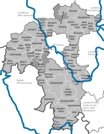
Communities
(Residents on December 31, 2019)
Community-free areas
|
Other communities
|
|
  |
Municipalities of the district before the territorial reform 1971/78
Before the regional reform, the Würzburg district had 45 municipalities (see list below). (The churches that still exist today are written in bold ):
| former parish | today's parish | today's district |
|---|---|---|
| Albertshausen | Reichenberg | Würzburg district |
| Bergtheim | Bergtheim | Würzburg district |
| Burggrumbach | Unterpleichfeld | Würzburg district |
| Eisingen | Eisingen | Würzburg district |
| Erlabrunn | Erlabrunn | Würzburg district |
| Estenfeld | Estenfeld | Würzburg district |
| Gerbrunn | Gerbrunn | Würzburg district |
| Geroldshausen | Geroldshausen | Würzburg district |
| Greussenheim | Greussenheim | Würzburg district |
| Güntersleben | Güntersleben | Würzburg district |
| Hettstadt | Hettstadt | Würzburg district |
| Hilpertshausen | Unterpleichfeld | Würzburg district |
| Hoechberg | Hoechberg | Würzburg district |
| Kirchheim | Kirchheim | Würzburg district |
| Box | Box | Würzburg district |
| Small cattle field | Small cattle field | Würzburg district |
| Kürnach | Kürnach | Würzburg district |
| Lengfeld | Wurzburg | Independent city of Würzburg |
| Lindflur | Reichenberg | Würzburg district |
| Maidbronn | Rimpar | Würzburg district |
| Margetshöchheim | Margetshöchheim | Würzburg district |
| moss | Geroldshausen | Würzburg district |
| Mulhouse | Estenfeld | Würzburg district |
| Oberaltertheim | Altertheim | Würzburg district |
| Oberdürrbach | Wurzburg | Independent city of Würzburg |
| Oberleinach | Leinach | Würzburg district |
| Randersacker | Randersacker | Würzburg district |
| Reichenberg | Reichenberg | Würzburg district |
| Rimpar | Rimpar | Würzburg district |
| Rossbrunn | Waldbüttelbrunn | Würzburg district |
| Rottenbauer | Wurzburg | Independent city of Würzburg |
| Rottendorf | Rottendorf | Würzburg district |
| Steinbach | Altertheim | Würzburg district |
| Theilheim | Theilheim | Würzburg district |
| Thüngersheim | Thüngersheim | Würzburg district |
| Uengershausen | Reichenberg | Würzburg district |
| Unteraltertheim | Altertheim | Würzburg district |
| Unterdürrbach | Wurzburg | Independent city of Würzburg |
| Unterleinach | Leinach | Würzburg district |
| Unterpleichfeld | Unterpleichfeld | Würzburg district |
| Veitshochheim | Veitshochheim | Würzburg district |
| Versbach | Wurzburg | Independent city of Würzburg |
| Waldbrunn | Waldbrunn | Würzburg district |
| Waldbüttelbrunn | Waldbüttelbrunn | Würzburg district |
| Zell am Main | Zell am Main | Würzburg district |
Protected areas
There are 18 nature reserves , eight landscape protection areas , twelve geotopes and 14 designated FFH areas in the district . (As of March 2016).
See also:
- List of nature reserves in the Würzburg district
- List of landscape protection areas in the Würzburg district
- List of FFH areas in the Würzburg district
- List of geotopes in the Würzburg district
License Plate
On July 1, 1956, the district was assigned the distinctive sign WÜ when the vehicle registration number that is still valid today was introduced . It is still issued today.
Until the 1990s, vehicles from the old district of Ochsenfurt received license plates with the letter pairs HA to JZ, MA to MZ and ZA to ZZ and the numbers from 1 to 99 and also with the letters J and Z and the numbers from 1000 to 9999.
Since July 10, 2013, the license plate liberalization has also resulted in the OCH (Ochsenfurt) distinguishing mark .
Web links
- Official website of the district of Würzburg
- Würzburg district . In: Bayern-Infos.de
- Würzburg district . In: Bayern-im-Web.de
- Literature from and about the district of Würzburg in the catalog of the German National Library
- Entry on the coat of arms of the district of Würzburg in the database of the House of Bavarian History
Individual evidence
- ↑ "Data 2" sheet, Statistical Report A1200C 202041 Population of the municipalities, districts and administrative districts 1st quarter 2020 (population based on the 2011 census) ( help ).
- ^ Wilhelm Volkert (ed.): Handbook of Bavarian offices, communities and courts 1799–1980 . CH Beck, Munich 1983, ISBN 3-406-09669-7 , p. 596 .
- ^ Wilhelm Volkert (ed.): Handbook of Bavarian offices, communities and courts 1799–1980 . CH Beck, Munich 1983, ISBN 3-406-09669-7 , p. 97 .
- ↑ http://www.wahlen.bayern.de/biz/kowa2014.php?schluessel=679
- ↑ Entry on the coat of arms of the Würzburg district in the database of the House of Bavarian History , accessed on September 5, 2017 .
- ↑ Würzburg district. In: Internet portal Historisches Unterfranken. District of Lower Franconia , accessed on January 8, 2011 .
- ↑ [1] - Life in the district. Accessed August 12, 2020.
- ↑ Future Atlas 2016. (No longer available online.) Archived from the original on October 2, 2017 ; accessed on March 23, 2018 . Info: The archive link was inserted automatically and has not yet been checked. Please check the original and archive link according to the instructions and then remove this notice.
- ↑ "Data 2" sheet, Statistical Report A1200C 202041 Population of the municipalities, districts and administrative districts 1st quarter 2020 (population based on the 2011 census) ( help ).
- ^ Michael Rademacher: German administrative history from the unification of the empire in 1871 to the reunification in 1990. wuerzburg.html. (Online material for the dissertation, Osnabrück 2006).
Districts:
Aichach-Friedberg |
Altötting |
Amberg-Sulzbach |
Ansbach |
Aschaffenburg |
Augsburg |
Bad Kissingen |
Bad Toelz-Wolfratshausen |
Bamberg |
Bayreuth |
Berchtesgadener Land |
Cham |
Coburg |
Dachau |
Deggendorf |
Dillingen on the Danube |
Dingolfing-Landau |
Danube Ries |
Ebersberg |
Eichstätt |
Erding |
Erlangen-Höchstadt |
Forchheim |
Freising |
Freyung-Grafenau |
Fürstenfeldbruck |
Fürth |
Garmisch-Partenkirchen |
Gunzburg |
Hatred Mountains |
Yard |
Kelheim |
Kitzingen |
Kronach |
Kulmbach |
Landsberg am Lech |
Landshut |
Lichtenfels |
Lindau (Lake Constance) |
Main-Spessart |
Miesbach |
Miltenberg |
Mühldorf am Inn |
Munich |
Neuburg-Schrobenhausen |
Neumarkt in the Upper Palatinate |
Neustadt an der Aisch-Bad Windsheim |
Neustadt an der Waldnaab |
Neu-Ulm |
Nuremberg Country |
Oberallgäu |
Ostallgäu |
Passau |
Pfaffenhofen an der Ilm |
Rain |
Regensburg |
Rhön-Grabfeld |
Rosenheim |
Roth |
Rottal-Inn |
Schwandorf |
Schweinfurt |
Starnberg |
Straubing Arch |
Tirschenreuth |
Traunstein |
Unterallgäu |
Weilheim-Schongau |
Weißenburg-Gunzenhausen |
Wunsiedel in the Fichtel Mountains |
Wurzburg
Independent cities:
Amberg |
Ansbach |
Aschaffenburg |
Augsburg |
Bamberg |
Bayreuth |
Coburg |
Erlangen |
Fürth |
Hof (Saale) |
Ingolstadt |
Kaufbeuren |
Kempten (Allgäu) |
Landshut |
Memmingen |
Munich |
Nuremberg |
Passau |
Regensburg |
Rosenheim |
Schwabach |
Schweinfurt |
Straubing |
Willows in the Upper Palatinate |
Wurzburg
Cities: Aub | Eibelstadt | Ochsenfurt | Röttingen
Markets: Bütthard | Eisenheim | Frickenhausen am Main | Gelchsheim | Gable City | Helmstadt | Höchberg | Neubrunn | Randersacker | Reichenberg | Remlingen | Rimpar | Sommerhausen | Winterhausen | Zell am Main
Municipalities: Altertheim | Bergtheim | Bieberehren | Eisingen | Erlabrunn | Estenfeld | Gaukönigshofen | Gerbrunn | Geroldshausen | Greußenheim | Güntersleben | Hausen near Würzburg | Hettstadt | Wooden churches | Kirchheim | Box | Small cattle field | Kürnach | Leinach | Margetshöchheim | Oberpleichfeld | Prosselsheim | Riedenheim | Rottendorf | Sonderhofen | Tauberrettersheim | Theilheim | Thüngersheim | Uettingen | Unterpleichfeld | Veitshoechheim | Waldbrunn | Waldbüttelbrunn
Unregulated areas: Gramschatzer Wald | Guttenberg Forest | Irtenberg Forest