
Weissenburg-Gunzenhausen district
| coat of arms | Germany map |
|---|---|

|

Coordinates: 49 ° 2 ' N , 10 ° 53' E |
| Basic data | |
| State : | Bavaria |
| Administrative region : | Middle Franconia |
| Administrative headquarters : | Weißenburg in Bavaria |
| Area : | 970.91 km 2 |
| Residents: | 94,734 (Dec. 31, 2019) |
| Population density : | 98 inhabitants per km 2 |
| License plate : | WUG, GUN |
| Circle key : | 09 5 77 |
| NUTS : | DE25C |
| Circle structure: | 27 municipalities |
| Address of the district administration: |
Bahnhofstrasse 2 91781 Weissenburg |
| Website : | |
| District Administrator : | Manuel Westphal ( CSU ) |
| Location of the Weißenburg-Gunzenhausen district in Bavaria | |
  |
|

The district of Weißenburg-Gunzenhausen is the southernmost district of the Bavarian administrative district of Middle Franconia . It was created in 1972 through the amalgamation of the districts of Gunzenhausen and Weißenburg , the previously independent city of Weißenburg and some communities in neighboring districts. The district has around 95,000 inhabitants, a total area of around 970 square kilometers and is divided into 27 municipalities with five administrative communities . It belongs to the West Central Franconia planning region and is part of the Nuremberg Metropolitan Region . Located south of Nuremberg, the rural region forms the border between the cultural areas of Franconia , Swabia and Old Bavaria . The area of today's district has always had a favorable traffic situation.
The largest city in the district and at the same time the seat of the Weißenburg-Gunzenhausen district office is Weißenburg in Bavaria . The city of Gunzenhausen is slightly smaller . Since 2010 the district has used the motto " Altmühlfranken - the strong south" as an advertisement for the region. The Altmühltal Nature Park and the Franconian Lake District brought the district a tourist boom.
geography

Geographical location
The district of Weißenburg-Gunzenhausen is located near the geographical center of Bavaria in the part of West Central Franconia known as Altmühlfranken , south of Nuremberg , northwest of Ingolstadt , north of Augsburg and southeast of Ansbach . In the northwest it borders on the district of Ansbach , in the northeast on the district of Roth , both in Middle Franconia , in the southeast on the Upper Bavarian district of Eichstätt and in the southwest on the Swabian district of Donau-Ries . Even part of the metropolitan region of Nuremberg , the district borders directly on the metropolitan region of Munich in the south, while the metropolitan region of Stuttgart begins not far in the southwest .
North-east of Haardt , the 11th degree of longitude and the 49th degree of latitude intersect in the district. The Central European Time (CET) is preceded at the outermost limit of the West County local time by 17 minutes and 29 seconds, at the extreme eastern border by 15 minutes and 12 seconds. In Gunzenhausen, Bavaria's first geodetic reference point for determining geographic coordinates was set up ( location ).
Landscape image


The district has a share of three natural areas : In the south, the Franconian Alb with its sub-mountains Weißenburger Alb , Anlauteralb , Monheimer Alb and Hahnenkamm extends with wooded plateaus; in the middle part it merges into the Alb foreland and this in the north into the Middle Franconian Basin . The southern half of the district in particular is characterized by a varied mountain landscape. In the east and south the region is geographically separated from the neighboring regions by the Franconian Alb , in the west by the Hahnenkamm . In the center of the district is a bay opening to the north with a hilly landscape and some witness mountains such as the Flüglinger Berg and the Trommetsheimer Berg . The Absberg Table Mountains begin north of the Altmühl , between Altmühl and Swabian Rezat the valley of the Weißenburger Bay , where the Franconian Alb forms a characteristic steep drop. This is where the Swabian Rezat rises, which has dug a kilometer-long furrow into the landscape to the north. The extreme southwest lies on the edge of the Nördlinger Ries , the remains of an old impact crater formed during the Ries event about 14.6 million years ago. The districts of Mäuskreuth and Kronhof in Polsingen are the only places in the district that are located in the Ries crater. The northwest reaches almost to the area around the Hesselberg ; this largest mountain in the neighboring district of Ansbach is visible in parts of the western half of the district. The Schlossberg at Heidecker district Schlossberg in the neighboring county Roth, whose southern foot is still in the district, determined the image of the northeastern county territory.
Large parts of the district center and parts of the north are taken up by a forestless open landscape . Only the low mountain ranges are mostly forested. Larger forests in this area are the Weißenburger Stadtwald and the Raitenbucher Forst . In the far north there are pine and spruce stands to the west near Pleinfeld . Mönchswald , Haundorfer Wald and Graefensteinberger Wald , in which the coniferous forest dominates, are among the largest contiguous forest areas in Bavaria. From Ornbau (district of Ansbach) to Treuchtlingen the Altmühl flows in a wide flood plain with little gradient. Between the cities of Gunzenhausen (416 meters above sea level) and Treuchtlingen (412 meters above sea level), about 20 kilometers away as the crow flies, the river falls only a few meters in altitude; This makes it one of the slowest rivers in Europe. From Dietfurt in Middle Franconia , the Altmühl dug a breakthrough valley through the Franconian Alb. In addition to the valleys through which water flows, there are dry valleys such as the Laubental and the Heuberger Tal in this karst low mountain range . The north of the district is occupied by the foothills of the Spalter hill country and is characterized by the reservoirs of the Franconian Lake District .
There are several stone gullies along the northern edge of the Alb, it contains the largest number of such nature games among the districts of Germany . The approximately 150 meter long and 0.2 meter high Käsrinne near Heidenheim and the Steinerne Rinne near Wolfsbronn , 128 meters long and 1.5 meters high, are the longest of these “growing streams” in Bavaria. See also the list of stone gutters in Bavaria .
Mountains and elevations

Large parts of the district, especially in the south and east, are characterized by plateaus and the layered landscape of the low mountain ranges. To the north lies the Spalter hill country near Kalbensteinberg and Absberg . North of the Alb there are several witness mountains and especially along the Alb eaves large elevations. The highest in the district is 656.4 m above sea level. NHN high Dürrenberg near Heidenheim . It is also the highest elevation of the Frankenalb, the Hahnenkamm and the second highest Middle Franconia. The next lower mountains in the district are the Efferaberg ( 645.2 m ), the Spielberg ( 642.4 m ), the Laubbichel ( 635.7 m ), the Hörlesbuck ( 634.7 m ), the Steinbühl ( 632.1 m ) which Gehäubichel ( 631.2 m ), the Rechenberg ( 630 m ), the Yellow mountain ( 628.4 m ), the mountain community (estimated 625 m ) and the Steinberg and on the plane , each with 624.7 m . The northeast bastion of the Wülzburg fortress on the top of the Wülzburger Berg reaches a height of 643.8 m above sea level. NHN . At 634 m , the Treuchtlingen district of Auernheim is the highest town in Middle Franconia. The 357 m above sea level. NHN lowest point of the district is on the Swabian Rezat near Mackenmühle ( location ). This results in a height difference of 299 meters in the district area.
Waters


The Altmühl flows through the district from north-west to south-east , where the places Muhr , Gunzenhausen , Treuchtlingen , Solnhofen and Pappenheim are located. Overall, the Altmühl flows through the district over a length of 51.62 kilometers. Other rivers are the 33.3 kilometer long Swabian Rezat , which flows through Weißenburg , Ellingen and Pleinfeld in the north , the 28.7 kilometer long Anlauter , which flows southeast through Nennslingen and the 24.1 kilometer west Rohrach that runs through Heidenheim and Polsingen moves south. Larger rivers are still the Möhrenbach (19.1 kilometers), the Thalach (17.8 kilometers), which mostly flows through the district of Roth , the Brombach (17.0 kilometers), the Felchbach (15.4 kilometers), the Treuchtlinger Schambach (14 , 2 kilometers), the Wurmbach (12.9 kilometers) and the Ostliche Rohrach (12.0 kilometers). Stream systems like the Banzerbach and the Brombach or the meandering Möhrenbach shape parts of the landscape.
Artificial ponds are the Fossa Carolina which to 793 Charlemagne was create, built in the 1970s, the Altmühlzuleiter and from 1976 to 1978 created Altmühl About Head . Several ponds such as the Eichenberger Weiher and the Schnackenweiher characterize the landscape north of the Albrand.
The European main watershed separates the river systems of the Rhine in the northern and the Danube in the southern part of the district. A number of places are located directly on the watershed and are therefore "divided in two" from a hydrological point of view. The southernmost point of the Bavarian section of the Rhenan-Danubian watershed in the north of the Danube is in the Treuchtlingen area near the Carolina fossa. A frequently mentioned curiosity is the building at Bergener Strasse 4 in Geyern , which stands exactly on the watershed. Until the renovation of the gutters in 1996, the rainwater flowed on the south side to the Ringelbach and thus to the North Sea and on the north side to the Anlauter and thus towards the Black Sea .
There are no major natural lakes in the district. As part of the water regulation of the Main-Danube Canal and the water supply of the arid northern Bavaria as well as for local recreation and tourism, several reservoirs in the Franconian Lake District were created from the 1970s . In the event of flooding at the Gern gauge near Ornbau, water is fed to the Altmühlsee via the Altmühl feeder. There it is temporarily stored and, if the level is exceeded, it is transferred to the Brombachsee via the Altmühlüberleiter . From there, the water flows over the Brombach into the Swabian Rezat, near Georgensgmünd into the Rednitz and then on to Nuremberg, before reaching the Main over the Regnitz. So water that would normally end up in the Danube via the Altmühl can be diverted towards the Main if necessary. The building project was decided by the Bavarian State Parliament on July 16, 1970 at the initiative of MP Ernst Lechner and completed in the late 1990s. Some smaller lakes, which have nothing to do with the water management task of the lakes, are also assigned to the lake district for tourist purposes. In addition to the Rothsee (Roth district) and the Dennenloher See (Ansbach district), the following lakes in the Franconian Lake District are located in the district:
| lake | construction time | surface | Storage space | particularities | image |
|---|---|---|---|---|---|
| Great Brombachsee | 1983-1999 | 8.7 km² | 136.6 million m³ | The Großer Brombachsee is the main lake in the Lakeland and at the same time the largest lake in northern Bavaria in terms of area. It is located in the valley of the eponymous Brombach, which opens to the east, and has a water depth of up to 32.5 meters. In the west it borders directly on the Kleiner Brombachsee and in the northwest on the Igelsbachsee. Two long dams separate these two pre-dams from the Großer Brombachsee itself. After the lakes were dammed, the water table in the area rose. |

|
| Altmuehlsee | 1976-1985 | 2.5 km² | 13.8 million m³ | With a crown length of 12.5 kilometers, the extensive and shallow Altmühlsee has the longest dam in Germany. In the event of flooding , the excess water from the Altmühl is fed into the lake via the Altmühl feeder; the Altmühlüberleiter drains it into the Kleiner Brombachsee. Almost half of the lake is a nature reserve. The lake is used intensively for tourism. After algae spread in the lake, the agricultural land use in the region was adapted to combat them. |

|
| Little Brombachsee | 1975-1985 | 2.5 km² | 12.9 million m³ | The Kleine Brombachsee is the western pre-barrier of the Großer Brombachsee. Most of its water is obtained from the Altmühlsee via the Altmühlüberleiter. The water is released through a dam in the east into the little lower lying Großer Brombachsee. |

|
| Igelsbachsee | 1979-1985 | 0.9 km² | 4.4 million m³ | The Igelsbachsee is the west-north-west pre-barrier of the somewhat lower lying Großer Brombachsee. It is fed by the eponymous Igelsbach . |

|
| Hahnenkammsee | 1975-1977 | 0.23 km² | 0.5 million m³ | The Hahnenkammsee is the oldest and smallest reservoir in the Franconian Lake District. Although it has nothing to do with the water management task of the lake district, it is one of the tourist and administrative tasks. It was dammed much earlier than the other lakes to compensate for the retention areas lost in the course of the land consolidation and as a recreational lake. The lake is known for its rich fish stocks. |

|
Climate and water shortage

Due to its location in Central Europe , the Weißenburg-Gunzenhausen district has a humid, cool, temperate transitional climate that is neither very continental nor very maritime. In the district, the weather in the plains and in the mountains is often different. The high altitudes are usually colder and windier than the lower ones, the snow falls earlier and lingers longer; the spring holds up about five to eight days later catchment than about lying in deep white castle. Due to the shielding effect of the low mountain ranges, some areas of the district have less precipitation than the neighboring regions. In addition, in the eastern Jura or in the Hahnenkamm, the limestone subsoil is karstified and the landscape is therefore very dry and arid.
This is why some places, such as Auernheim , were only able to cover their water needs through cisterns until they were connected to the public water network . Kattenhochstatt , which lies on the watershed from which the water drains quickly, suffered particularly from a lack of water. On the Alb plateaus in the east of the district there are largely no running waters on the sandstone or fissured Jurassic limestone soils. The settlements used to be supplied with water from numerous clay- lined ponds, cisterns and very deep wells. In contrast to this, the Altmühl in the west of the district often leads to floods, because heavy rainfall flows only slowly due to the often very low gradient of the valley.
In the course of the 20th century, numerous sources such as the Steinriegelquelle or the Hirschspring spring were gradually opened up for water extraction. With their embankment, they feed the public water network to which the villages are connected. Since then there has been no more water shortage.
- Precipitation diagrams

Auernheim
(Jura, near the Hahnenkamm)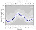
Mandlesmühle
(near Brombachsee, low altitude)
Nennslingen
(Jura plateau, in the east)
Stopfenheim
(open landscape)
Solnhofen
(Altmühltal in the Jura, southeast)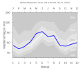
Obererlbach
(extreme northwest)


Flora and fauna

Under conditions not influenced by humans, the district would be covered with forests of different types depending on the location (“ potential natural vegetation ”). The most widespread would be beech and mixed beech forests as well as oak-hornbeam forests and in the north acidic mixed oak forests. In the present, the flora of the Weißenburg-Gunzenhausen district is determined by deciduous and coniferous forests, as is typical for southern Germany. Large parts of the northern half of the district lie in a wide open landscape with meadows , fields and only a few individual trees, and even on the not very fertile Jura plateaus there is a remarkable proportion of open land. Lean and dry grassland , extensively used grassland in particularly nutrient-poor (“lean”) or dry locations are widespread .
In Spielberg , the Obstarche is a project to preserve local fruit varieties in the district, including those that are not yet recognized as apple and pear varieties and are only native to this region. An important habitat for plants is the Buchleite at Markt Berolzheim .
As in other parts of Germany, only relatively few large animal species live in the forests. There are different species of marten , fallow and red deer , roe deer as well as wild boars and foxes . More and more beavers are spreading along many rivers , causing damage to agriculture, which is why the district provides volunteer "beaver advisors".
The shallow water and island zone in the Altmühlsee and the Wiesmet are roosts for numerous bird species, in March 2015 Egyptian geese , buzzards and Mediterranean gulls were observed.
A large number of fish species that occur in Central Europe such as eels , pike , pikeperch , lake trout , rainbow trout , catfish and non-ferrous fish such as carp , tench , roach , rudd and bream thrive in the waters of the district . These fish species reach the reservoirs of the Franconian Lake District via the Altmühlwasser. While a stable perch population has formed in the Brombachsee , the number of pike over one meter in length is falling due to the high fishing pressure.
The district has unique sand habitats for southern Germany, which are protected as Franconian sand axis .
Geology, fossils and seismology


The near-surface subsurface of the district consists mainly of unfolded Mesozoic rocks from the southern German layered plains . Jura deposits dominate the Franconian Alb. During the White Jura , today's district was largely in the area of the marginal sea of the western Tethys Ocean . This shallow sea area was divided by mighty sponge reefs and lagoons in which limestone and dolomite stones were deposited. The deposits of the reef bodies and the fine-grain lagoon limestone and marl form the majority of the Franconian Alb. Due to the drop in sea level towards the end of the Upper Jurassic, larger areas initially became mainland again at the beginning of the following Cretaceous period . In the course of the Upper Cretaceous the sea advanced again into the area of the Franconian Alb. At the end of the Upper Cretaceous, it finally withdrew from the region. Large parts of southern and central Germany were tectonically influenced as a long-distance effect of the elevation of the Alps in the Tertiary and broken down into high and deep clods.
While the southern half of the district is dominated by the Upper Jura of the low mountain range, sediments from the Black and Brown Jura predominate in the center of the district , as well as loess , loam and Pleistocene river gravel and sand along the Altmühl and in the Weißenburg basin . In the north, however, the sandstone dominates - Keuper of the Franconian Keuper-Lias-Land . In the extreme south and southwest of the district, ejecta and sediments from the crater filling of the Ries impact can be found underground . Holocene river deposits can be found in the Treuchtlingen area as well as along the Altmühl and Brombach lakes. The most recent geological formations include the stone gullies or “growing brooks”, which were created under favorable circumstances in the area where the carbonate rocks are distributed.
In the region around Langenaltheim and Solnhofen there is the Solnhofen limestone , a lithostratigraphic rock unit of the Solnhofen Formation ( White Jura ) known for its fossil inclusions . The predominantly light, yellowish rocks of the White Jura are mined in various places. Other limestones of the upper Malm mined in the district are sold under the trade name Jura marble .
One of the most famous and most common dinosaur species in Central Europe occurred in the Middle Keuper : Plateosaurus engelhardti , an early representative of the Sauropodomorpha , of which there is an important site in Ellingen . Far more famous is the ancient bird Archeopteryx , which was found in the Solnhofen fossil site, among other places. In the very fine-grain, laminated lagoon limestones, the Archeopteryx, the pterosaur Pterodactylus , the Theropoda Compsognathus , six genera of pterosaurs , various turtles and bony fish , numerous invertebrates, such as hair stars and dragonflies , have been handed down in great detail. Two specimens of the Archeopteryx are exhibited in the Solnhofen Mayor-Müller Museum .
The extreme south of the district is in an area that is weakly prone to earthquakes . The bedrock is rocky.
Geotopes, nature and landscape protection areas


In the Weißenburg-Gunzenhausen district there are 14 nature reserves with a total area of 551.57 hectares . The nature reserve bird sanctuary shallow water and island zone in Altmühlsee with the archipelago “Vogelinsel” is visited by over 200 bird species every year and, with an area of 202 hectares, is the largest protected wetland in the district. The Schambachried is one of the oldest nature reserves in Middle Franconia. In the Märzenbecherwald near Ettenstatt , the rare Märzenbecher , which adorns the coat of arms of the municipality of Ettenstatt , transforms the forest floor into a white carpet in spring. Other protected areas are the alluvial forest near Westheim , the oak - hornbeam forest Laubenbuch near Rothenstein , the Grafenmühle on the south bank of the Großer Brombachsee, the peninsula in the Kleiner Brombachsee , the grasslands of the nature reserve Quellhorizonte and grasslands at the Albtrauf near Niederhofen , the Brombachmoor , the last Naturally preserved area of the Brombach Valley, the Twelve Apostles rocks that shape the landscape , the Buchleite near Markt Berolzheim , the dam of the Igelsbachsee , the Sägmühle nature reserve and the Steinerne Rinne near Wolfsbronn .
In the district there are 52 (as of August 2016) designated geotopes by the Bavarian State Office for the Environment . Among them are the Carolina Fossa, the Twelve Apostles Rock and the Solnhofen Limestone fossil site, due to their beauty and rarity, among the most beautiful geotopes in Bavaria . The Altmühltal and the Solnhofen limestone became National geotopes explained and by a commission as potential candidates for the World Heritage Program of UNESCO elected. The south of the district belongs to the Ries Geopark .
Many other areas are also designated as Fauna-Flora-Habitat ( FFH areas ) by the European Union in order to provide better protection for wild species, to preserve their habitats and to ensure their Europe-wide networking. The natural monuments in the Weißenburg-Gunzenhausen district include over 80 individual trees, mainly linden trees , several wetlands, forests and the Carolina fossa . The Franconian sand axis was the title of a project by several environmental associations to protect rare sand habitats along the Rednitz , Pegnitz and Regnitz rivers . The Weißenburg-Gunzenhausen district formed the southern end of the project area. These sand habitats include the overhead line between Mischelbach and Röttenbach in the neighboring district of Roth, the sand areas near Hörlbach and the area around the Mandlesmühle in Brombachtal . The landscape protection areas in the Weißenburg-Gunzenhausen district include several cross-district areas. Parts of the district, for example along the Altmühl, are designated as a European bird sanctuary .
The district is located in the northern part of the Altmühltal Nature Park , which was founded in 1969 and is one of the largest nature parks in Germany with an area of around 3,000 square kilometers . The nature park is shaped by the low mountain range of the southern Franconian Alb. Their typical landscape features are dry grasslands , juniper heaths , wet meadows and quarries .
To the north of Muhr am See and the Altmühlsee lies the Wiesmet , one of the largest and most important wetlands in southern Germany. It is an important habitat for various bird species.
Expansion and land use
With 970.91 square kilometers, the district is in the middle of the Bavarian districts in terms of area. It is smaller than most of the districts of Middle Franconia but larger than the neighboring district of Roth. The municipality with the largest area in the district is Treuchtlingen, the one with the smallest Muhr am See . The district boundary is around 238.7 kilometers long. The maximum north-south extension is around 37.7 kilometers; the largest west-east extension around 42 kilometers.
The southernmost point of the district and at the same time Franconia and Middle Franconia is located in the municipality of Langenaltheim southeast of the main town in the forest area Oberholz on the Wittesheimer slopes ( Lage ), the northernmost in the municipality of Haundorf northwest of Oberhöhberg near the summit of the Hinteren Mönchsberg ( Lage ). The easternmost point of the district is located in the municipality of Nennslingen northwest of Biburg in the Bergfeld corridor ( Lage ), the westernmost in the area of Markt Westheim southwest of the main town in the Auwald near Westheim nature reserve ( Lage ). The geographical center , which is calculated from the mean values of the four extreme coordinates of the district, is located between Trommetsheim in the north and Lengenfeld in the south in the area of the municipality of Alesheim in the Heidenburg Flur ( location ) and is not marked. Near Langenaltheim, a stele in the Röglinger Valley marks the border triangle , where the administrative districts of Middle Franconia, Swabia and Upper Bavaria meet, and thus the cultural areas of Swabia, Franconia and Old Bavaria.
A third of the area is covered by forests, around half is used for agriculture. Settlement and traffic area, with around 10,867 hectares, represents 11.2 percent of the district area. Since 1980, the settlement area and the water area in particular have increased. There was a decrease in the agricultural area, the forest area has remained constant since 1980. According to the Bavarian State Office for Statistics, the district area was divided as follows in 2013 :

Spatial planning
According to the planning regulations for spatial planning in the planning region West Central Franconia (Region 8), the cities of Weißenburg and Gunzenhausen are two of a total of six medium- sized centers in West Central Franconia. The city of Treuchtlingen is classified as a possible medium-sized center. The only sub-center of the district is Pleinfeld, small centers are Nennslingen, Heidenheim, Pappenheim, Markt Berolzheim and Ellingen. Overall, the Weißenburg-Gunzenhausen district is part of the rural area . The district does not belong to any agglomeration of a regional center ; the nearest regional centers are Nuremberg and Ansbach.
Quality of life and security
The district is characterized by a comparatively high quality of life . The Prognos Future Atlas of 2013 confirms that it has a balanced risk-opportunity mix and the district climbed by around a hundred places in its ranking compared to the Future Atlas of 2010. In a livability study by Focus , it was ranked 27th out of 402 districts, with the region doing best in the wealth category and worst in the living space and infrastructure category. The district was thus recognized as a “particularly liveable region”. In the regional ranking of INSM , it was 170th out of 435 districts in 2006, and 137th out of 409 districts in 2009, praising the low debt of residents and communities and the good job security. The study criticized the low tax force and the low proportion of highly qualified and engineers in the population. In the Germany study by ZDFzeit , the district achieved the third highest value in Middle Franconia in 2017, and in Germany it landed 67th out of 401 places.
The region is comparatively safe in terms of crime. In 2014, 3.8 percent of all crimes in Central Franconia were committed in the district area. Compared to the previous year, the number of reported crimes in the district fell by 3.3 percent to 3537 in 2014, and the clearance rate was 74.9 percent. In 2013 there were 0.33 road deaths per 100,000 inhabitants. In 2016 there were 3,185 traffic accidents, 90 fewer than in 2015. In 2016, 584 people were injured and four people were killed. The largest accident focus in the district is the Hörnlein intersection in Weißenburg.
population
.JPG)
On December 31, 2012, 92,187 people lived in the Weißenburg-Gunzenhausen district, 46,552 of them women (50.5 percent). About a fifth of the total population was under 20 years old and a little more than a quarter older than 60. In 2016 there were 873 births, 1,041 deaths, 4,108 immigrants and 3,289 emigrations. In 2005 there were 25,842 residential buildings with 41,776 apartments. The total living space was 4,260,621 square meters, which corresponds to an average living space of 45.01 square meters per person. This value is slightly above the Bavarian average of 42 square meters per person. The average age in 2015 was 44.5 years and has increased by 2.8 years since 2005.
With around 95,000 inhabitants, the district is roughly in the middle of the Bavarian districts . It is the poorest district in Middle Franconia, but it has around 30,000 more inhabitants than the poorest district in Bavaria, the Lichtenfels district . The largest municipality in the district is Weißenburg with 18,645 inhabitants, other larger towns are Gunzenhausen , Treuchtlingen and Pleinfeld . The smallest municipality in the district is Gnotzheim with 824 inhabitants. This results in a population density of around 95 inhabitants per square kilometer, making the district one of the less populated regions in Bavaria (comparison: Bavaria's average 179 inhabitants per square kilometer).
The main population centers are along two rivers: around 23,000 people live in the towns along or near the Swabian Rezat and around 33,000 along or near the Altmühl. About half of the district population lives in the three largest cities of Weißenburg, Gunzenhausen and Treuchtlingen. The Jura plateau in the area of the Nennslingen administrative community and the Hahnenkamm region in the area of the Hahnenkamm administrative community and the center of the district are comparatively sparsely populated.
In 2014, 13,459 disabled people lived in the district , including 10,856 severely disabled people . The average number of children per family in 2014 was 2.0 (Germany-wide 1.4), the proportion of families with many children was 20 percent (Germany-wide 15.4 percent).
The proportion of foreigners was 8.8 percent in 2017, in April 2018 there were 8,593 foreigners from 131 nations and 15 stateless people living in the district, as well as 458 asylum seekers and refugees. 61 people were naturalized. Most of the foreigners come from Bosnia-Herzegovina, Bulgaria, Greece, Iraq, Italy, Kosovo, Croatia, Austria, Poland, Romania, Russia, Syria, the Czech Republic, Turkey, Ukraine and Hungary. A little under a sixth of all foreigners come from Turkey.
.JPG)
religion
As in almost all of Middle Franconia, large parts of the district are predominantly Protestant. The denominational orientation reflects the territorial structure at the time of the Franconian Empire up to the present day . Areas that were in the former sphere of influence of the Hochstift Eichstätt or the Teutonic Order are Catholic. On the other hand, the former territories of the imperial city of Weißenburg , the Pappenheim marshals and the principality of Ansbach are dominated by Lutherans. Later historical events such as the influx of refugees after the Second World War and increasing mobility are increasingly blurring the denominational boundaries.
On May 9, 2011, there was an Evangelical Lutheran majority of 55.6 percent compared to around 29.0 percent Catholics . The Protestant population belongs to the deaneries Gunzenhausen and Heidenheim in the parish of Ansbach-Würzburg as well as to the Evangelical Lutheran deanery in Weißenburg and to the Evangelical Lutheran deanery in Pappenheim in the parish of Nuremberg . The Catholic parish members belong to the deanery Weißenburg-Wemding in the diocese of Eichstätt . There is an Evangelical Methodist congregation in Weißenburg . A majority of Catholics compared to Protestants exists in the district only in Pleinfeld, Gnotzheim, Ellingen and Raitenbuch . According to Article 1 of the Bavarian Law on the Protection of Sundays and Public Holidays , Assumption Day (August 15) is a public holiday in these communities .
With the influx of guest workers and migrants, Islam is of growing importance . There is a Muslim community in Weißenburg that is close to DİTİB . The Pappenheim Mosque is a center of the radical Muslim Tablighi Jamaat in Bavaria, along with Munich . There are other mosques in Treuchtlingen and Gunzenhausen.
Historically, today's district was a strongly Jewish region , today there are no more Jewish communities. In 1987, 10 people with Jewish religious affiliation were still living in the district.
In 2011, 15 percent of the residents did not belong to any or a religious community outside the Protestant and Catholic Church.
| year | Residents |
|---|---|
| 1840 | 55,513 |
| 1871 | 57,956 |
| 1900 | 62.157 |
| 1925 | 65,359 |
| 1939 | 64,497 |
| 1950 | 94.193 |
| 1961 | 85,958 |
| 1970 | 88.201 |
| 1987 | 86,381 |
| 1991 | 91,554 |
| 1995 | 94.046 |
| 2003 | 95,227 |
| 2004 | 95 054 |
| 2005 | 94,660 |
| 2006 | 94.163 |
| 2007 | 93,711 |
| 2008 | 93.009 |
| 2009 | 92,586 |
| 2010 | 92,326 |
| 2011 | 92.182 |
| 2012 | 92.187 |
| 2013 | 92,331 |
| 2014 | 92,518 |
| 2015 | 93,342 |
| 2016 | 93,974 |
| 2017 | 94.208 |
| 2018 | 94,393 |
| 2019 | 94,734 |
Population development
The following overview (table on the left) shows the population of today's district area. The figures are census results up to 1987 and official updates from the Bavarian State Office for Statistics from 1991 .
After the Second World War, the population increased by almost half due to the immigration of displaced persons, while it had increased by around a fifth in the previous hundred years. From 1988 to 2008, the Weißenburg-Gunzenhausen district grew by over 6,000 inhabitants (around 7 percent). From 2003 onwards, after a peak of over 95,000 inhabitants, the trend was down, on average the population decreased by around 300 annually. Since 2011 the population has been increasing again. Between 2011 and 2015, the population increased by around 200 annually. In 2014 it was 92,518, roughly the same as in 2009. In 2018, the population was 94,393, roughly the same as in 2006 and just below the high of 2003.
In the medium term, however, the population in the district, as in most of Germany's rural regions, could decline. This has to do with the departure of qualified people who do not see any prospects due to a lack of university locations and highly qualified jobs in the surrounding area. This trend is to be counteracted with the University of Applied Management in Treuchtlingen and the Kunststoff Campus Bayern in Weißenburg, as well as the establishment of the State Office for Schools in Gunzenhausen and the construction of a motorway connection to the A9.
The Bavarian State Office for Statistics and Data Processing forecast a population of 85,000 in 2030, in 2014 a population of 86,600 in 2032 and in 2016 a population of 90,800 in 2034. These were the highest predicted population declines in Central Franconia at the time, but were far below the declines in the rural regions of Upper Palatinate, Lower and Upper Franconia.
At the end of 2016, the Bavarian State Office for Statistics and Data Processing did not forecast a medium-term decline for the first time in years, but rather a stagnation in the population of the region with around 93,000 inhabitants in 2035. By around 2032, a slight population growth to around 94,000 district residents is assumed. This is mainly due to the influx of refugees , internal migration and intra-European migration to Bavaria. The maximum value of 2004 with around 95,000 inhabitants will probably no longer be reached.
places
Duration


According to the Bavarian State Office for Statistics and Data Processing, there are 333 officially named places in the Weißenburg-Gunzenhausen district ; According to statistics from the Weißenburg-Gunzenhausen district, there are 297 places. Of these, only Gunzenhausen and Weißenburg had an urban character until the late 19th century, and later Treuchtlingen as well; most of the other places have remained more or less rural. Among them, Ellingen with its baroque buildings and Pappenheim with its well-planned, medieval town center are worth mentioning. There are currently five places in the district with municipal rights , six markets, 16 “other” municipalities and numerous parish and church villages and hamlets . What is striking is the quite high number - around a third of the places - of wastelands with mostly only one residential building. For example, along the Mühlenstrasse from the Ketschenmühle on the northern edge of Pleinfeld to the Heinzenmühle on the northern border of the district, there are about a dozen desert areas along the Swabian Rezat. The lost places include Leonhardsruh near Gunzenhausen, an example of a place that disappeared due to urban overbuilding, and the Öfeleinsmühle , an example of over a dozen wastelands that were demolished in the flooding area of the reservoirs in the Franconian Lake District. Other locations such as Furthmühle and Langweidmühle were rebuilt at a new location after the flooding.
According to the Historical Atlas of Bavaria , Volume Gunzenhausen-Weißenburg, the study area of which roughly covers the area of today's district, there were four cities (Weißenburg, Gunzenhausen, Ellingen, Pappenheim) and seven markets with more than 100 properties ( Absberg , Altenmuhr , Berolzheim ) in 1792 , Gnotzheim, Heidenheim , Pleinfeld, Treuchtlingen). There were also 15 villages with more than 75 (mainly along the Altmühl and in the Hahnenkamm), 72 villages with more than 20, 67 villages and hamlets between 5 and 20 and 164 small settlements with fewer than five properties.
Type of settlement and name etymology
The settlement types of the villages are not uniform. Many places are row villages , including street villages like Eichenberg or Hochholz . Others are clustered villages , Emetzheim is an example of a ring village . Many places built around a Anger , z. B. Ettenstatt and Meinheim .
While some places have names that only exist once, other place names are common within Germany and internationally. This includes, for example, the church mountains with dozens namesakes in Europe as Bergen auf Rügen , Bergen near Neuburg , Bergen im Chiemgau or the Norwegian mountains . For better differentiation, some places have a name suffix, such as Weißenburg in Bavaria, Gundelsheim an der Altmühl , Haag near Treuchtlingen , Dietfurt in Middle Franconia , Reuth am Wald or Reuth under Neuhaus . Some place names even appear several times within the district, such as Fuchsmühle, Geislohe, Gundelsheim, Kohlmühle, Neuherberg, Reuth, Sägmühle, Zollmühle and Ziegelhütte. Many names refer to the geographical location of the respective place, for example with the endings -bach ( Obererlbach , Veitserlbach , Störzelbach ), -berg ( Wehlenberg , Oberappenberg , Büchelberg ), -feld ( Ottmarsfeld , Edersfeld , Pfraunfeld ), -bronn ( Büttelbronn , Wolfsbronn ) and so on. A total of 68 places with the ending -mühle emerged from water , paper and sawmills . Places with the endings -heim ( Ostheim , Ehlheim , Sammenheim ), -hausen ( Weiboldshausen , Dornhausen , Thannhausen ), -ing ( Walting ) or -ingen ( Hüssingen , Rehlingen , Eßlingen ) indicate that a place was founded during the migration period, especially during the Franconian conquest between the 6th and 9th centuries.
Other places were founded later, for example Haardt and Neudorf are clearing settlements that were created around 1300 , while Rothenstein did not develop until the 18th century, Schleifer am Berg only around 1850.
Most populous communities and places
The largest municipality in the district is the district town of Weißenburg i.Bay. with 18,645 inhabitants including all districts, followed by Gunzenhausen with 16,616 inhabitants, Treuchtlingen with 12,952 inhabitants, Pleinfeld with 7556 inhabitants in fourth place, Pappenheim with 4039 inhabitants in fifth place and Ellingen with 3851 inhabitants in sixth place. Four other municipalities have between 2000 and 3000 inhabitants, 13 between 1000 and 2000 inhabitants and four municipalities with less than 1000 inhabitants. Gnotzheim with 824 inhabitants, Meinheim with 841 inhabitants and Ettenstatt with 836 inhabitants have the fewest inhabitants.
A total of 10 communities can be classified as small towns , the rest as rural communities .
If the entire municipality including all districts is not considered, but only the places themselves, Weißenburg remains the largest place in the district with around 13,500 inhabitants. This is followed by Gunzenhausen with around 10,900, Treuchtlingen with around 7290, Pleinfeld with around 4320, Ellingen with around 2300 and Muhr am See with 2150 inhabitants. Six other places have between 1000 and 2000 inhabitants, the rest under 1000. The largest place in the district, which is not the capital of a municipality, is Wettelsheim with around 1400 inhabitants.
history
prehistory

In the area of the Weißenburg-Gunzenhausen district there are traces of human presence along the low mountain range from the Mesolithic and from the time of the earliest rural cultures of the Neolithic . Numerous finds of triangular microliths , stone axes , open-air stations and burial mounds , for example near the Alte Bürg, testify to this . Coming from the Danube region, people of the Rössen and band ceramic culture settled in the Neolithic Age . Numerous graves date from the Bronze Age , the largest collective grave in the region can be found in Wettelsheim, where at least 15 people were buried in a stone chamber.

From the Urnfield Culture in 1908 (around 1300 to 800 BC. Chr.) Testify to 1911 found walled settlements on the Yellow Mountain , jewelry or arrow quiver from the Hallstatt period (800 to 450 BC. Chr.). Finds from the more recent Hallstatt period are more sparse, which points to a lesser settlement or a settlement interruption. Walled settlements from the Hallstatt period, for example on the Yellow Mountain, have been known for a long time. Numerous other prehistoric settlements, which have often been declared land monuments , bear witness to the rural settlement history of the region, in many places they are only visible through aerial photographs . The presence of the Celts in the Latène period is evidence of burial mounds , square entrenchments and section walls . When the Romans arrived, the Celts fled to hilltop settlements. In and around Westheim there is perhaps the largest Celtic barrow field in southern Germany with 244 burial mounds.

Romans (late 1st to mid 3rd century AD)
15 BC The Roman province of Raetia was established. Under Emperor Domitian a 2.8 hectare wood and earth fort was built near Weißenburg around 90 AD in the immediate vicinity of a Celtic oppidum . His garrison served to secure the area conquered north of the Danube, which had recently been incorporated into the province of Raetia . Under Emperor Commodus the construction of the Limes began , which he and his successors had secured by a road network and forts as well as by expanding the existing forts, such as the Biriciana fort near Weissenburg, which from the middle of the 2nd century a stone Alenlager of 3.1 hectares The area was 170 by 174 by 179 meters. Biriciana became a small Roman town in which around 150 perhaps 5,000 people lived, half of the population of the provincial capital Augusta Vindelicorum (Augsburg), and where thermal baths were built.

In the winter of 1867, during construction work, a 16 by 13 centimeter, as usual, double bronze plaque, a military diploma , from the year 107 was found, as it was awarded to veterans at the end of their service, and the original of which remained in Rome. On this copied diploma the earliest inhabitants of Biriciana known by name are recorded, the rider Mogetissa "Comatulli filius Boius" (a Celtic Boier ), his wife Verecunda "Casati filia" (probably also a Celtic Sequan woman ) and their daughter Matrulla. In addition, a gold coin, six silver and 22 copper coins as well as ceramics and other remains were found at this fort not far from the "Teufelshecke", as the Limes was called at the time.
In Burgsalach , the small fort “In der Harlach” is one of the most extraordinary structures on the Limes. This type of construction is otherwise only found in North Africa. Finds from Roman times are a Roman parade helmet from Theilenhofen and several statues of gods from the Weißenburg Roman treasure .
From late antiquity to the late Middle Ages
Alamanni (from around 253), Franks (around 500), Christianization
Around 253, the Romans withdrew to the south behind the Danube in the course of the Alemanni invasions . At Dittenheim, there was soon an Alemannic hilltop castle, the Yellow Citizen, to control the region .

The cemetery at Westheim dates back to the early Merovingian period, which dates back to shortly after the victory of the Franks over the Alamanni and thus to the early 6th century, and the cemetery at Weißenburg , which also dates from this time , is the largest of its kind in Middle Franconia. The grave fields were occupied by Franconian and Thuringian warriors and their families.
Due to the Franconian conquest , the later district area became part of the Sualafeldgau on the border between Franconia, Bavaria and Swabia. The Swabian Rezat formed the border between Sualafeldgau and Nordgau .
The Christianity , at the end of the 5th century adopted by the Frankish king, first spread from the 6th century by Irish monks from. They were followed in the middle of the 8th century by Anglo-Saxon missionaries who were sometimes canonized and to whom a number of monasteries were founded. These were done by Wunibald († 761), Walburga († 779?) And Sola († 794) after the establishment of the diocese of Eichstätt . This is how monasteries came into being with their manors , such as Heidenheim (752), Solnhofen (761) or Gunzenhausen (before 823). During this time, a number of localities in the district were first mentioned in documents, such as Trommetsheim (750), Bubenheim (792) and Gunzenhausen (823), Weißenburg (867), Altenmuhr (888) and Bieswang (889). At this time the first local nobility emerged in many places, which often soon went out again.
Weissenburg, abandoned by the Romans shortly after the Alaman's invasions, became the center of a royal estate district around 750, a royal palace for the traveling king. In 867 Weißenburg appeared as a curtis with a suburbium and Merovingian period village settlement.

Under Charlemagne , attempts were made to create the Fossa Carolina , a navigable connection between Altmühl and Swabian Rezat and thus between the Rhine and the Danube . The Fossa Carolina is often referred to as the predecessor of today's Rhine-Main-Danube Canal . According to the Vita Sualonis of Ermanrich von Ellwangen , the Altmühl was a river "navalibusque mercimonio aptum", suitable for ships and commercial goods, but whether the fossa was ever completed is a matter of dispute. The assumption by chroniclers that unfortunate soil and weather conditions led to the abandonment of the project are regarded as incorrect, because the majority of contemporary sources report that the sewer is ready and usable. The fact that it was hardly used and that it was abandoned shortly after its construction was due to the great effort that the canal passage required. The efforts of the traders in their day-to-day business did not seem to be worth it. From the Fossa Carolina an approximately 500 meter long water surface and adjoining earth walls made of excavated material up to 10 meters high have been preserved.
County of Lechsgemünd-Graisbach, Free Imperial City of Weißenburg, Teutonic Order Ball

In the High Middle Ages, the parishes belonged to various ecclesiastical and secular rulers. The rulers and local aristocratic families shaped the area for many centuries with their castles and palaces, some of which are still complete, others as ruins. From the 9th century the area of the district belonged to the area of influence of the county of Lechsgemünd-Graisbach . With a clever acquisition policy, the Hohenzollern expanded the territory of the Burgraviate of Nuremberg ; The Hohenzollern Margraviate of Brandenburg-Ansbach emerged from their territory .
Weißenburg developed into a city as early as 1150 and after a planned expansion with a wall after 1170 . But it was not until 1241 that cives was first mentioned . 1302 consules are documented, around 1350 the city council was able to emancipate itself from the Hohenstaufen office bearer of the royal city lord. As cives , the residents of the city were referred to, who had voting and assembly rights due to urban ownership; If consules appear in the sources , this is a sure sign of the established right of the community to meet and to form a body to discuss its own affairs and to find law (consulatum tenere). In 1358 the written record of municipal rights began, and in 1377 a new council statute was created. After the inclusion of a suburban settlement developed in the south, the urban area after 1370 comprised a total of 26 hectares with around 2000 inhabitants.
From 1296, Weißenburg was designated as an imperial city , and it was able to maintain this status, although the superiority of the imperial city of Nuremberg in economic terms and the purely regional commercial importance of Weißenburg led to the bankruptcy of the city. This was mainly due to massive expenditures in connection with the construction of the town hall between 1470 and 1476, the never finished new tower from 1459, the new wall, the hospital or the purchase of the village of Suffersheim in 1465. After the bankruptcy of 1481, it changed Emperor Friedrich III. the entire city council and gave Weißenburg in 1481 a new coat of arms in its current form. For a decade, the imperial immediacy was threatened by this catastrophe, because in 1481 3,900 guilders of annual income were set against current expenses of 12,000 and a mountain of debt of 120,000 guilders.

Ellingen, which emerged from a hospital foundation, developed into the capital of the Deutschordensballei Franconia . In many places, knight families acquired goods, such as the Rieter von Kornburg in Kalbensteinberg , the von Geyern taverns in Geyern , the Truhendinger in the Hahnenkamm area, the Gundelsheimers in Gundelsheim , the Rechenberger in Ostheim and the Oettinger at Spielberg Castle . The Pappenheimer ministerial family , who first appeared at the beginning of the 12th century, held the title of Reichsherbmarschall from 1420 and shielded Franconia from the Duchy of Bavaria .
The Hochstift Eichstätt acquired the Sandsee Castle and the area around Pleinfeld from 1302 . The monastery Peter and Paul , founded probably in the 11th century, acquired numerous goods in the region, such as the monasteries Fulda , St. Gallen and Auhausen . Free villages were in today's district of Hechlingen , Auernheim and Nordstetten .
The economically and politically less important region was drawn into the wars of the higher powers and the neighboring centers. The Bavarian War took place from 1420 to 1422 , a dispute between Ludwig VII of Bavaria-Ingolstadt and Heinrich XVI. from Bavaria-Landshut , the lower Altmühltal and the Hahnenkamm badly affected. In this Dettenheim , Oberhochstatt and Solnhofen burned Dornhausen was largely destroyed. In 1449, the imperial city of Weißenburg was drawn into the war against the Margrave of Ansbach through its ties to Nuremberg . Albrecht Achilles , who strove for territorial rule primarily against the resistance of Nuremberg and whose house had held the Margraviate of Brandenburg since 1413 , had taken over Ansbach in 1440 and joined the Mergentheimer Fürstenbund in 1445 . Around the Franconian imperial cities a circle of destruction, 20 to 30 kilometers wide, arose in places, so that in Central Franconia in the years 1449 and 1450, extensive devastation of the country is assumed.
Economically, the cities of the region benefited from the long-distance trade routes to a limited extent, as they connected the area to the main trade centers. So the Weißenburger Steig , the later Rennweg, moved from Weißenburg to Nuremberg. Martin Luther used this route on his return trip from Rome to Nuremberg and on his return trip to and from the Augsburg Reichstag . Weissenburg was at the intersection of the Nibelungenstrasse from France to Southeast Europe and the Amber Road, a name that only appeared in the 18th century, from northern Germany to Italy. In the communities, inns and customs stations were built, the sovereigns built castles and fortifications to secure the trade routes.
Jews settled in the district at an unknown point in time. During the rintfleisch pogrom of 1296 and the pogroms of 1348/49 Jews were murdered in Weißenburg. At this time there were also Jews living in Gunzenhausen. The oldest evidence dates from 1334, after the pogrom it was not until 1374 that a Jew was recorded in the village for the first time. In the directory of the Jewish communities in the diocese of Eichstätt from 1480, it is stated that there are many Jewish families living in Gunzenhausen.
Modern times
Franconian Empire, Reformation, witch hunt

The Franconian Imperial Circle was created in 1500 by Maximilian I in order to better guarantee the peace in the Holy Roman Empire . The members included the imperial city of Weißenburg, the Hochstift Eichstätt and the Ansbach margraves. Pappenheim and other noble families were in return members of the Franconian knight circle ; today's district area belonged to the territory of the knight canton Altmühl . In the Absberger feud destroyed Swabian League in 1523 several castles whose owners the robber baron Hans Thomas from the family of Absberger supported. In the area of today's district, the Berolzheim Castle and the Absberg Castle were completely destroyed.

Georg “the Pious” pushed through the Reformation in the Margraviate of Ansbach in 1528 ; the imperial city of Weißenburg followed after the Confessio Augustana was signed on November 15, 1530. The hereditary marshals von Pappenheim and the Schenk von Geyern also introduced the new doctrine. The Reformation was introduced in Wengen in 1528, in Unterasbach in 1529, in Laubenzedel in 1532, in Mariabrunn around 1535, in Bergen in 1543, in Wachstein in 1545 and in Ehlheim in 1559.


Only the possessions of the Teutonic Order and the Hochstift Eichstätt remained as Catholic areas . Counter-Reformation efforts ultimately failed. Thanks to Gottfried Heinrich zu Pappenheim , General of the Catholic League , Treuchtlingen became Catholic again at times. Changes of denomination of the predominant aristocratic families were thwarted by the Margraves of Ansbach.
During the Peasants' War in 1525, the nobles in the Rezat area fled from the rebels to Ansbach, where they joined the armed forces of Margrave Casimir . However, those gathered there on April 3rd came to no conclusion about their action against the unrest, as only Eichstätt accepted Ansbach's claim to leadership. Their backsides had joined the rebels as well as those of the Teutonic Order, and in Eichstätt on April 2, about 200 cloth journeymen demanded the restoration of their fishing rights. This is symptomatic, because the peasants had often risen to restore their "old rights". Insurgent farmers asked Bishop Gabriel and the Eichstätt council to open the gates on April 24th. Although Kurbayern intervened while Eichstätt had to remain inactive militarily, the Bavarians did not use this to mediate, although there were considerations. On May 7, 1525, the rebellious peasants suffered a heavy defeat at Rechenberg near Ostheim against the margravial troops of Kasimir. But on May 29, the margrave was defeated by the farmers at Windsheim under the leadership of Gregor von Burgbernheim . When the farmers finally lost to the Swabian Federation on June 2, a brutal revenge followed, even for the circumstances at the time. In order to prevent the uprisings feared by the Eichstätt bishop, he took two mandates against the Anabaptists in 1528 , because he regarded their work as the main cause of the peasant war.
Although the first witch trials in the area of the Hochstift Eichstätt for witchcraft and sorcery began as early as 1411, the persecutions did not reach their peak until around 1590. In Ellingen at least 70 alleged witches were executed in the months before 1590. In January 1590 two women were also burned in Weißenburg under pressure from the monks and after a request for expert opinions in Nuremberg. One died as a result of torture in May 1591. A general instruction "for the eradication of the highly guilty vice of sorcery and witchcraft" was issued on October 12, 1593. The persecution, to which at least 426 people fell victim in the Eichstätt monastery, lasted until 1637. Witch mandates followed until 1696. A review for the outside public has not yet existed.
Confessional wars, Ansbach an Prussia, Jewish communities
The Thirty Years War , which began in 1618, spared the region until 1631. In the following years, however, almost all villages were pillaged or destroyed; the region was depopulated and plagued by epidemics such as the plague . The war, and in its wake hunger and epidemics, had wiped out 40 to 70 percent of the population in Franconia. In the course of the war, for example, the Holy Cross Chapel near Pfofeld was destroyed, the official seat of the Teutonic Order Land Commander in Ellingen and Pappenheim Castle were burned down. The Hahnenkamm area was particularly hard hit. Tilly's troops took the Wülzburg fortress in 1631, and it became the main imperial base in the region.
Protestant religious refugees from Austria and France, who settled in the Margraviate of Ansbach and other Protestant territories and cities, helped to a large extent in the reconstruction after the war . Between 1680 and 1730, 38,000 to 44,000 people fled France, of whom around 4,000 settled in the Margraviate of Ansbach and in Brandenburg-Bayreuth.

During the War of the Spanish Succession , the Weißenburg Line , a Landwehr with 21 entrenchments, was created on March 15, 1704 to defend the region after the defeat of the Frankish Empire near Höchstädt . It was supposed to protect the Reichskreis, which stood on the side of the Austrians, from Kurbayern, which fought on the French side. The French troops held Pappenheim, whose castle was damaged, and Treuchtlingen at that time. The line was not completed because the French were defeated in a second battle . The Sternschanze in the forest near Dettenheim , which measures 60 meters diagonally , is well preserved . The other, square, jumps have sides of around 22 meters.
After the last Margrave of Ansbach, Karl Alexander, renounced his rule, the former Margrave of Ansbach was incorporated into Prussia in 1792 . This also meant the mediatization of the imperial knighthood , which was subordinate to the Prussian king. This sometimes violent process of extensive change and standardization of personal and small-regional rights dragged on until 1798.
At the end of the 18th century, Johann Kaspar Bundschuh reported that the Altmühltal was known for its wealth, while the residents of more distant places such as Langlau , Brombach or the Hahnenkamm area were poor and lived in smaller, thatched houses.
_Synagoge_101.jpg)

From 1658 Jews were only allowed to settle in the area of the Hochstift Eichstätt in the town of Cronheim . One of the most important Jewish communities in the region came into being in Treuchtlingen. The communities grew significantly after all Jews were expelled from the Duchy of Palatinate-Neuburg in 1741 . Jewish communities existed in Altenmuhr (from the first half of the 18th century), Ellingen (from 1540), Cronheim (early 17th century to 1630, 1650–1938), Treuchtlingen (around 1348 and from 1540), Weimersheim (before 1770, until the end of the 19th century), Dittenheim (before 1773 to around 1880), Pappenheim (before 1314 to 1935), Markt Berolzheim (before 1631 to 1938/42) and Heidenheim (before 1714 to 1938). The Jewish community of Gunzenhausen, which reached back to the 14th century, was largely dissolved in 1539 and 1560. In 1583 there was again a small synagogue. In the first half of the 17th century Gunzenhausen was one of the more important communities in the Principality of Ansbach and until 1693 the seat of the land rabbi. After the Jews were expelled from Herrieden (1681), some of them settled in Gunzenhausen. In 1714 there were 28 taxable families in Gunzenhausen, in 1755 there were 55. Some residents complained about the new economic competition that the Leipzig trade fair visited. From the middle of the 19th century, the number of Jews declined as a result of the Bavarian Jewish edict of 1813 , which stipulated a maximum number of Jews per location. In Central Franconia there were 55 Jewish schools in 1840, such as the school founded in Altenmuhr in 1831.
Connection to Bavaria (from 1803), modern administration
During the Napoleonic Wars , the area was repeatedly occupied by Prussian, Russian, Austrian and Bavarian troops. From 1803, the later Kingdom of Bavaria received large parts of today's district through secularization and mediatization with the Reichsdeputationshauptschluss under pressure from Napoleon . Weißenburg lost its imperial freedom and first came to Prussia. In the so-called Rittersturm , Bavaria occupied the tiny territories of the Imperial Knights , which often only comprised a few villages, from 1803. In 1806 Prussia also had to surrender the Ansbach territory it had acquired in 1792 to Bavaria. Raitenbuch came to the Principality of Eichstätt of Archduke Ferdinand of Tuscany in 1803 and fell to Bavaria in 1806.

The state administration was rationalized to a greater extent, following the French model, the state's access to every single citizen was enforced and special rights were largely eliminated. In 1808 the regional courts of Weißenburg , Gunzenhausen , Pleinfeld and Heidenheim were established, which initially belonged to the Altmühlkreis , from 1810 to the Oberdonaukreis and from 1817 to the Rezatkreis , which was renamed Middle Franconia in 1838 . With the community edict of 1808/1811, today's communities came into being. In 1852 the former rulership courts Ellingen and Pappenheim became the regional courts Ellingen and Pappenheim , which from 1862 formed the district office Weißenburg with the regional court Weißenburg . The district courts of Gunzenhausen and Heidenheim were combined to form the Gunzenhausen district office. The city of Weißenburg left the district office of Weißenburg on July 16, 1863 and became a city directly within the district . In 1880 the Gunzenhausen district office was enlarged to include four communities from the dissolved Heilsbronn district office . The district offices became the districts.
Industrialization and rail connection
In the 19th century, numerous producers of Leonean goods settled in Weißenburg . The state-run Ludwigs-Süd-Nord-Bahn opened the Pleinfeld – Gunzenhausen – Cronheim –Nördlingen section of the Nuremberg – Augsburg railway line in 1849 . The city of Ansbach built a connecting line to Gunzenhausen in 1859 at its own expense , which the Bavarian State Railways extended to Treuchtlingen in 1869. At the same time, the direct connection from Pleinfeld via Weißenburg to Treuchtlingen was established, which was continued in 1870 through the Altmühltal to Eichstätt and Ingolstadt . The line from Treuchtlingen in the direction of Donauwörth – Augsburg over the Franconian Alb could not be put into operation until 1906.
World wars, the time of National Socialism (until 1945) and pogroms against the Jews

During the First World War , the Wülzburg fortress was used as a prisoner of war camp. In 1918, the future French President Charles de Gaulle was imprisoned there until the end of the war in November 1918, interrupted by an attempt to escape. The total number of those killed in the First World War is 2372.


Middle Franconian Protestantism was very close to National Socialism . The NSDAP had become very strong in Middle Franconia under its Gauleiter Julius Streicher towards the end of the 1920s. As one of the first cities in the Reich, Gunzenhausen distinguished itself by discriminating against the Jewish population. The first Hitler memorial in the German Reich was erected there in April 1933, and the son of a Jewish butcher was seriously injured in Gunzenhausen in March. On March 25, 1934, one of the first Jewish pogroms in Germany after the seizure of power took place in Gunzenhausen , the “Palm Sunday Pogrom ”, also known as “ Blood Palm Sunday” . Led by the local SA under Obersturmführer Kurt Bär, the mob - a total of 1,000 to 1,500 of the 5,600 inhabitants were involved - broke into the houses of the Jews and deported about 30, according to other sources 35 of them to the local prison. This resulted in acts of violence in which Max Rosenau and Jakob Rosenfelder died. The attack was reported in the press around the world: The New York Times , the Manchester Guardian and the New Vienna Journal wrote about the acts of violence, which the Ansbach judges played down as a "cleansing thunderstorm" during the trial. While most of the prisoners were released in the next few days, Leonhard Baumgärtner remained in "protective custody" in Weißenburg for months. The innkeeper Simon Strauss was murdered on July 15, 1934 by Kurt Bär. During the Reichspogromnacht in November 1938, numerous Jewish communities in the district were forcibly dissolved.
During the Second World War , the Wülzburg Fortress was an internment camp for Soviet prisoners of war. At the Fallgarten there is the Russian Cemetery , in which the grave of the Prague composer Erwin Schulhoff is located next to the graves of 40 Russian merchant sailors .
As part of Operation Clarion , Allied air raids took place on February 23, 1945, including on Treuchtlingen station . In total, almost 600 people were killed in and around the station. Another attack on April 8th destroyed large parts of the city, but nobody was killed. Most of the bomb victims are buried in the Memorial of the War Graves Commission on the Nagelberg . 94 people died in Ellingen during Operation Clarion, with great damage in the area of the baroque city center; Around 70 tons of bombs were dropped. 22 people were killed in Weißenburg. Pleinfeld, Solnhofen and Gunzenhausen were also attacked in 1945. The invasion of American troops ended the war in Weissenburg on April 23, 1945.
From the American occupation to the merger of the two counties
After the Second World War, the district area belonged to the American zone of occupation . The Wülzburg was a refugee camp for expellees from the Sudetenland and Silesia , about 25,000 of them settled in the region. In the Weißenburg pogrom trial , the largest in the American zone of occupation until then, those responsible for the pogrom of 1938 against the Jewish population of Treuchtlingen were convicted from 1946 to 1947. In May 1949 the participants in the pogroms of 1938 were tried before the district court in Ansbach; five were acquitted and five were sentenced to three to eight months in prison.
From the 1960s onwards, land consolidations and village renewals took place in many communities . On the initiative of Ernst Lechner , the Bavarian State Parliament decided on July 16, 1970 to set up the Franconian Lake District in southern Central Franconia in order to secure the water regulation of the Main-Danube Canal and to improve the supply of the arid northern Bavaria . On October 13, 1973 grazed a US fighter plane type F-4 Phantom II in low-level flight one armored personnel carrier type M113 and crashed between Trommetsheim and Katte Hochstatt from. The two pilots and two soldiers of the tank were killed.

Coat of arms of the district of Weißenburg in Bavaria

Coat of arms of the Gunzenhausen district


As part of the regional reform in Bavaria , a new district of Weißenburg in Bavaria was formed on July 1, 1972 from the following components :
- Until then independent city of White Castle in Bavaria, the status of a district town received
- All communities of the old district Weißenburg in Bavaria, with the exception of the municipality Mühlstetten that the district Roth came
- The communities of the dissolved district of Gunzenhausen with the exception of twelve communities that came to the districts of Ansbach, Donau-Ries and Roth
- The municipalities Gundelsheim and carrots from the dissolved district Donauwörth , of the administrative region of Swabia belonged
- The communities of Biburg and Wengen from the dissolved Hilpoltstein district
On May 1, 1973, the new district was given its current name: Landkreis Weißenburg-Gunzenhausen . During the municipal reform, Stopfenheim lost the market rights it had been granted in 1349. In 1976 the two places Altenmuhr and Neuenmuhr merged to form the unitary community of Muhr am See .
The two former districts of Gunzenhausen and Weißenburg had a total of 131 municipalities until the beginning of the regional reform in the early 1970s, of which 30 remained, of which three were added to the district of Ansbach.
Sights, art and culture
Landmarks and architecture
Castles, palaces and fortresses

Numerous palaces, castles and castle ruins are distributed over the district. Ellingen Castle is particularly well known . The residence of the Landkomturs of the Ballei Franken of the Teutonic Order was built from 1708 to around 1760 in the baroque style. The large palace garden and the baroque facade of the palace symbolize the wealth of the Teutonic Order. The Pappenheim Castle was the seat of the marshals of Pappenheim and was probably made around 1030. The two-part system is one of the most noble castles franc and the most important ruins of the region. Other castle ruins in the district are, for example, the Obere Veste in Treuchtlingen and the Bechthal Castle above the village of the same name . The fortress Wülzburg, built in the Renaissance style above the district town of Weißenburg, is one of the few preserved fortresses in the German-speaking area with the typical Renaissance fortifications. It has been registered as a nationally significant architectural monument since 1969 . In the drama The robbers immortalized Friedrich Schiller , the castle Altenmuhr .
Churches and monasteries

The district is particularly rich in churches with different architectural styles. Romanesque , baroque, renaissance, margrave style or historicism alternate or are sometimes combined in one building. There are a total of 154 church buildings in the district with regular church services . The predominant building type of village churches is the choir tower church , followed by the hall church . Pilgrimage churches are the Blasius Church in Raitenbuch and the Gunthildiskapelle near Suffersheim . In addition to the saints typical of southern Germany, the church patrons include Willibald , Walburga , Gunthildis and Sola, who are especially venerated in the Eichstätt diocese . The church patrons of the St. Hieronymus Church in Wachenhofen and the St. Gallus Church in Pappenheim are rather unusual for the region . The Gallus Church dates from the 9th century and is therefore the oldest church building of Carolingian origin in Franconia and one of the oldest churches in southern Germany . Also among the oldest church buildings in Germany are the remains of the Solnhofen Sola basilica , which, with its columns from Carolingian times, is one of the greatest art-historical sights in Middle Franconia.
The Rieterkirche in Kalbensteinberg is important . The church, built in the 15th century, served as the crypt church of the Rieter von Kornburg ; they furnished it with many art treasures, which is why it is called the "Franconian treasure chest". A Gothic processional figure and a Russian icon are of great importance in the inventory . In the 8th century, the Heidenheim Monastery was one of the first monasteries in the region . With its three-aisled pillar basilica from the 12th century, it is one of the most famous and best-preserved monastery ensembles in the region. The Teutonic Order built the magnificent church of St. Augustine in Stopfenheim in the baroque style. Other Baroque churches worth mentioning for tourists are the Teutonic Order Church of St. Vitus in St. Veit and the St. Ottilien Church in Absberg. There are numerous fortified churches in the district that offered protection to the population in the Middle Ages.
Roman buildings

With the advance of the Romans into the province of Raetia, they settled in the area of today's district. They left behind several buildings, one of which is the large thermal baths in Weißenburg, which were discovered in 1977 . This remarkable relic is one of the few remaining thermal baths on Germanic soil. It is located on the site of the Roman fort and Vicus Biriciana , which, with its reconstructed north gate, is one of the district's attractions. The entire complex has been a UNESCO World Heritage Site since 2005, as is the nearby Limes . In Burgsalach , the small fort “In der Harlach” is one of the most extraordinary structures on the Limes. Its construction is unique in Central Europe and only exists in North Africa. Other Roman forts in today's district are Iciniacum near Theilenhofen , Mediana near Gnotzheim and Sablonetum near Ellingen.
Historic city centers

The old town of the district town of Weißenburg is one of the most impressive city centers and monument ensembles in the district . Weißenburg, first mentioned in a document in 867, was built around a Carolingian royal court and received the status of a free imperial city in the early 14th century, which it was able to maintain until 1802. In 1376 the city was expanded to the south. This created a younger, southern and an older, more densely built-up northern old town. In the center of the northern old town is the old town hall , built in Gothic style from 1470 to 1476. The rectangular market square , which extends to the hospital gate, begins on its south side ; Luitpoldstrasse , the former timber market, extends on the west side and is remarkable for its size. On the east side, the Rosenstrasse and the Am Hof square are connected . Magnificent town houses and half-timbered buildings from medieval times, such as the Lebküchnerhaus and the Blue House, line these main streets . To the east of the town hall is the large, Gothic-style St. Andrew's Church , built in the Gothic style from 1294 to 1327 , whose tall hall choir, added in the 15th century, is considered a work of the southern German late Gothic . The old town is framed by the almost completely preserved wall ring from the 14th and 15th centuries. The best-known building of the city wall is the Ellinger Tor .

The state-approved resort town of Gunzenhausen was first mentioned in 823 and expanded by the Ansbach margraves into a baroque-style residence. The historic market square is characterized by important buildings that were either built during the reign of the “Wild Margrave” Karl Wilhelm Friedrich (1729–1757) or were given their present-day appearance, such as today's town hall , which was once his residence, and several city palaces . Individual half-timbered houses are spread across the cityscape. A piece of the medieval fortifications are battlements and three towers preserved: the Blasturm from the 15th century, the dyer tower (around 1300) and the Stork Tower (1450). In the southern part of the old town stands out the town church of St. Maria , which dominates the cityscape and was built from 1448 to 1461 in the Gothic style.

Pappenheim, located on an Altmühlschleife and known from Schiller's drama Wallenstein's death (“ I know my Pappenheimers ”), is closely connected to the Pappenheimer noble family who resided in the castle above the town. In the High Middle Ages, Pappenheim was expanded into an urban settlement as planned. Town houses, the 15th century town church St. Marien and some palaces shape the townscape. Some half-timbered buildings in Jura construction have been preserved.

Ellingen was strongly influenced by the Teutonic Order. East of the residence of the Landkomtur, built from the 18th century in the form of today's palace complex, Ellingen was built in the area of today's Hinteren Gasse and was expanded as planned to become a town in the Baroque style. In addition to the castle, the town hall and the parish church of St. Georg set the tone. The baroque style finds its echo in the town houses, especially in the Neue Gasse , which was laid out from 1749 under the direction of Matthias Binder . The orangery and the Maria-Hilf chapel were built in the 18th century . Due to the many baroque buildings, the city describes itself as the "Pearl of the Franconian Baroque" for tourist reasons.

House shapes
The Jura house is a house form the Altmühltal, for example, in Nennslingen , Bieswang , Burgsalach , mountains , Dettenheim , Pappenheim and Langenaltheim be found. Characteristic for this type of construction are relatively shallow sloping roofs covered with several layers of thin limestone slabs made from Solnhofen limestone, the so-called "Legschieferplatten". In the northern half of the district there is the Franconian sandstone house and high-gabled hop store.
Stone crosses
There are numerous stone crosses in the district , most of which are also listed as architectural monuments .
Sports and clubs
There are many opportunities to do sports in the district. The sports clubs offer sports ranging from basketball and volleyball to athletics to chess and table tennis . One of the most popular sports is soccer . The football division of TSV 1860 Weißenburg , founded in 1860, played in the main round of the DFB Cup in 1974/75 . In the course of the tourist development, numerous hiking trails were created that can be used for jogging and Nordic walking . Water sports such as sailing and canoeing can be practiced on the lakes of the Franconian Lake District and along the Altmühl . The sailing catamaran Eagle is manufactured in Muhr am See . He achieved a new speed record on the long-distance regatta on Lake Balaton . The latest variant of the type is a catamaran - foiler , which also achieved a speed record. The buildings in the Zollmühle district of Ellingen are located in the middle of an 18-hole golf course. The German Golf Teachers Federation has its headquarters in Weißenburg . Sports highlights in the region are the Altmühlsee run and the Lakeland marathon . Well-known athletes from the region are the soccer players Sebastian Glasner and Markus Steinhöfer as well as the Olympic silver medal winner Antonia Katheder .
The water sports center of the Friedrich-Alexander-Universität Erlangen-Nürnberg , which went into operation in July 2003, is located at the southern end of the dam on the Großer Brombachsee and offers university members sailing courses with dinghies or catamarans , kayaking and triathlons .
In addition to the lakes and ponds, there are also three thermal baths and seven outdoor pools in the district for swimming.
Outside of sport, the residents of the district are active in numerous shooting clubs, nature conservation organizations, church associations, political parties and youth organizations. Many organize themselves in the fire departments. There are 127 volunteer fire brigades in the district with a total of around 5500 active forces. The Gunzenhausen fire department founded in 1865 and the Weißenburg fire department founded in 1867 are among the oldest. There is a local branch of the technical relief organization in Gunzenhausen and Treuchtlingen .
There are a total of around 1200 clubs and associations in the district. The largest sports club in the district is TV 1860 Gunzenhausen with 2441 members (as of 2019).
Museums

The museum portal of the Free State of Bavaria lists 24 museums in the district. Most of them deal with regional issues, often against a historical background. This includes the Pleinfelder Heimatmuseum , to which the first brewery museum in Middle Franconia showing the history of brewing culture is attached. There are also various art museums and private galleries. The local history museum of the city of Weißenburg is the Reichsstadtmuseum Weißenburg , which shows the medieval history of the imperial city and its inhabitants as well as the history of the expulsion of the Germans from Czechoslovakia in the attached Kaaden house .
The East Prussia cultural center has been located in the west wing of Ellingen Castle since 1981 . It serves to preserve and maintain the East Prussian cultural heritage with exhibitions, archives, a gallery and a museum.
In the Museum of Pre- and Early History Gunzenhausen finds from the Neolithic to the early Middle Ages are shown; Special objects are grave goods from the Westheim burial ground as well as Roman, Hallstatt and Latency finds . The Pappenheim Castle is publicly accessible as a museum and shows the history of the chivalrous life and the town of Pappenheim; attached is a small hunting museum.

In Weißenburg is the Roman Museum , which reopened on March 15, 2017 , a branch museum of the Archaeological State Collection Munich . The exhibition focuses on the prehistoric and early historical cultures of the region. It shows important archaeological finds, such as the Roman treasure of Weißenburg . The Bavarian Limes Information Center is connected. The Weißenburg Pharmacy Museum shows a historical pharmacy facility from the time of the pharmacist and Limes researcher Wilhelm Kohl .
The collection of the Folklore Museum in Treuchtlingen , built up by Josef Lidl , shows finds from excavations in Treuchtlingen Castle and furniture from the 17th to the 20th centuries. With over 20,000 exhibits, it is one of the largest folklore museums in Bavaria. The Mayor Müller Museum is in Solnhofen . In addition to numerous fossil finds and a lithographic collection, it is well known for having two specimens of the ancient bird Archeopteryx found in the region . Worth mentioning in Thalmannsfeld is a newly built, historically modeled forge in a residential stable house built around 1820/30, first mentioned around 1740. In this museum, among other things, transmission-driven drilling, turning and milling machines as well as a spring drop hammer from the years 1895 to 1920 can be seen.
Art, theater and literature

In addition to concerts, theater performances and sporting events organized by the district administration, the cities, markets and communities as well as the numerous clubs and groups in halls, museums and stages such as the Bergwaldtheater Weißenburg or during the Altmühlsee Festival , the art scene is also active in the Weißenburg-Gunzenhausen district . Time and again, private individuals and art associations organize vernissages , exhibitions and events, for example in the Weißenburger Schranne . With Carpe Diem, there is a local culture magazine in the region. The Treuchtlinger Literature Prize of the Wilhelm and Christine Hirschmann Foundation has been awarded in the field of literature since 2009 . The Altmühlfranken Youth Literature Prize, worth a thousand euros, has been awarded annually since 2015 . There are a total of three cinemas and five theaters in the district.
Events and customs


Throughout the year, numerous events, celebrations and festivals attract many visitors in the district. There is a parish fair in every larger town (120 in total), called “Kerwa”, “Kärwa”, “Kirwa” or “Körwa” in the local dialect. The parish fair has been celebrated as a religious festival on the occasion of the consecration of a Christian church building since the Middle Ages , today the religious context usually plays a subordinate role. In many places, church fair beer is brewed and church fair trees are set up. At the end of the Solnhofener Kirchweih, the "Kirchweihsau" is burned. In Dittenheim , the "Huhnerbaum" (chicken tree) is set up at a post-church fair and people dance around it. In addition to the church consecrations, village festivals or folk festivals take place according to their own traditions . The folk festival in Treuchtlingen has been celebrated in its current form since 1928. It is traditionally opened by " Gambrinus ", the king of beer adorned with a hop crown.
One of the most famous, largest and oldest festivals in the region is the Weißenburger Kirchweih , a meeting place for Weissenburgers from all over the world. The folk festival, first mentioned in 1455, is the largest in southern Franconia with around 70,000 visitors. The emigrants to America celebrated the Weissenburger Kirchweih in New York City in the 19th century .
The sporting highlights in the district include several running events, the cultural ones include the summer festival of the Bergwaldtheater in Weißenburg . From June to August, operas and plays have been performed there since 1929, with an interruption only during the Second World War. In many places in the region, on the day of Mariä Candlemas , the candlestick markets take place with Sunday shopping, in Weißenburg and Gunzenhausen on the first and in Treuchtlingen on the second Sunday in February. The large Christmas markets in the region include the St. Andreas Christmas market on the forecourt of the town church in Weißenburg and the Gunzenhausen Christmas market. Weißenburg celebrates the old town festival in July.
The municipalities of the district celebrate the more the Swabian-Alemannic carnival resembling Carnival , with strongholds in Ellingen and Pleinfeld, which differs markedly from the Rhenish Carnival.
kitchen
The cuisine of the Weißenburg-Gunzenhausen district traditionally has a Franconian character , and due to its proximity to other regions also a Swabian and Bavarian character. In addition to the typical Franconian dishes such as snowballs and Schäufele , the region's cuisine includes the very coarse Old Mill Franconian bratwurst , which is usually referred to as Merkendorfer , Gunzenhäuser, Spalter , Pfofelder, Weißenburger or Treuchtlinger Bratwurst.

Federal competition
Numerous villages from the district took part in the national competition Our village should be more beautiful - Our village has participated in the future and are fighting against rural exodus with village beautification . Gundelsheim an der Altmühl (1971), Kattenhochstatt (1967), Laubenzedel (1961), Meinheim (2015), Polsingen (1967), Sammenheim (1983), Thannhausen (1977), Trendel (1965), Wachstein were awarded as “Golddorf” (2001) and Windsfeld (1963 and 1998).
language
The Weißenburg-Gunzenhausen district is located in an area in which East Franconian , Swabian and Bavarian dialect features mix. While the Franconian dialects of the eastern half are Bavarian and the extreme east is in the northern Bavarian dialect area, Upper East Franconian dominates in the western half . Border towns of the Alemannic dialect area in the area of the district are Westheim , Hohentrüdingen , Roßmeiersdorf , Hüssingen , Oberappenberg , Ursheim and Polsingen .
Due to its remote location, Auernheim has developed its own dialect that is unique in the region and that differs greatly from the dialect of neighboring towns. With the help of local researcher Arthur Rosenbauer , a language atlas for the village dialect was created in 2014 .
Jewish culture


In the area of today's rural district, Jews first settled in the Middle Ages . In some places they made up up to a third of the population at times. During the rint meat pogrom and the plague pogroms of 1348/49 , many Jews were murdered in Weißenburg. In the city of Weißenburg, the Jews probably lived along today's Judengasse until they were expelled in 1520 . Numerous Jewish communities were founded, for example in Altenmuhr , Ellingen , Cronheim , Treuchtlingen , Weimersheim , Dittenheim , Pappenheim , Markt Berolzheim and Heidenheim . From 1658, Jews were only allowed to settle in the town of Cronheim in the entire area of the Hochstift Eichstätt . In Altenmuhr the Jews lived like a ghetto . One of the most important Jewish communities in the region came into being in Treuchtlingen. The communities grew significantly after all Jews were expelled from the Duchy of Palatinate-Neuburg in 1741 , many of whom settled here. In 1813 the district rabbinates of Dittenheim and Gunzenhausen were established . Numerous new synagogues were built in the 18th and 19th centuries, for example in Pappenheim , Ellingen and Heidenheim . From the middle of the 19th century, the number of Jews declined due to emigration as a result of the Bavarian Jewish edict of 1813 . Nevertheless, several Jewish associations shaped community life. Numerous commercial and industrial enterprises belonged to the Jewish families.
Due to the increasing disenfranchisement after 1933 and numerous violent and degrading actions against the Jews, more and more people moved to other cities or emigrated. One of the first Jewish pogroms of the Nazi era occurred in Gunzenhausen in 1934, which brought negative press reports for the city worldwide. In the course of the November pogroms in 1938 , numerous Jewish properties were desecrated and destroyed. Many of the district's Jews were murdered after the deportation. Those responsible for the Treuchtlingen pogrom were convicted in the Weißenburg pogrom trial. There are still three Jewish cemeteries in the district , in Pappenheim , Treuchtlingen and Gunzenhausen . The cemetery in Pappenheim is the oldest and largest. In many places, memorial stones and memorials remind of the region's Jewish past, for example in Treuchtlingen and Gunzenhausen.
politics
District Administrator
The district administrator is the legal representative and representative of the district as well as the chairman of the district council and most of its committees. He heads the district office and is an official of the district. In addition, he takes care of current affairs of the district administration on his own responsibility. The district administrator has been Manuel Westphal (CSU) since 2020 , the deputy district administrator is Robert Westphal (CSU).
- 1972–1996: Karl Friedrich Zink (initially independent, from 1975 CSU), was previously the district administrator of the Gunzenhausen district, the longest-serving district administrator in Middle Franconia
- 1996–2008: Georg Rosenbauer (CSU), previously Mayor of Ostheim and member of the Bavarian State Parliament
- 2008–2011: Franz Xaver Uhl (CSU), died in office on August 22, 2011
- 2011: Robert Westphal (CSU), acted as deputy district administrator on behalf of the deceased district administrator
- 2011–2020: Gerhard Wägemann (CSU), elected on November 20, 2011, previously a member of the Bavarian State Parliament, re-elected on September 24, 2017
- from 2020: Manuel Westphal (CSU), elected on March 15, 2020, previously a member of the Bavarian State Parliament
District council
The district council is elected for six years by those eligible to vote in the district. He is the decision-making representative body. According to the district regulations for the Free State of Bavaria , it basically decides on all important matters of the district in its own and transferred sphere of activity. The district council forms committees that decide for themselves within the framework of the rules of procedure or at least give advice in advance. In the Weißenburg-Gunzenhausen district, the district council has 60 members. There is a grand coalition of the CSU and the SPD.
The last local elections resulted in the following distribution of seats in the district council :
| Party / list | 1996 | 2002 | 2008 | 2014 | 2020 |
|---|---|---|---|---|---|
| CSU | 29 | 30th | 28 | 27 | 26th |
| SPD | 15th | 15th | 15th | 15th | 10 |
| Free voters | 8th | 8th | 8th | 7th | 9 |
| Green | 4th | 4th | 4th | 6th | 9 |
| ÖDP | 1 | 1 | 1 | 2 | 3 |
| FDP | 2 | 2 | 3 | 2 | 2 |
| The left | - | - | 1 | - | 1 |
| The Republicans | 1 | - | - | - | - |
| The left / pirates | - | - | - | 1 | - |
| total | 60 | 60 | 60 | 60 | 60 |
court House

The district office consists of several offices and has 269 employees. The main office is located in the old town of Weißenburg not far from the city library and has the address Bahnhofstraße 2. It extends over several buildings, including the listed buildings of the old district court and the former Augustinian monastery in Weißenburg . Some of the district administration's facilities are also located at Niederhofener Strasse 3 and Schwärzgasse 1. There is also a secondary service in Gunzenhausen (Sonnenstrasse 37b). The district office is a member of 11 special purpose associations.
elections
The district of Weißenburg-Gunzenhausen is located in the " constituency Ansbach-Süd, Weißenburg-Gunzenhausen " (for state elections) and in the " Bundestag constituency Ansbach " (for federal elections). The Weissenburg constituency was dissolved in 1976. In its 27th anniversary, the direct mandate of the Bundestag constituency Weissenburg always won the later Bundestag President Richard Stücklen (CSU). Member of Parliament of the region since the state election in Bavaria in 2013 consisting Meinheim originating Manuel Westphal (CSU), member of parliament of the region since the federal election in 2017 Artur Auerhammer (CSU), District Council of the region is Hans Popp . So far, the direct mandates of the constituencies have always gone to the CSU. The CSU has been the strongest force so far in the state parliament , as well as in the Bundestag and European elections , followed by the SPD . The CSU is elected by around half of the constituency population; it rarely reaches values above 60 percent. The SPD usually reaches between a fifth and a third of the electorate. The CSU had its best result in the 1999 European elections with 66.1 percent of the vote; The SPD achieved its best result with 35.5 percent of all votes in the 1998 state election . Other parties are usually below 10 percent. In the state elections, the free voters strengthened significantly. As in the whole of Germany, a steady decline in voter turnout can be observed. In the elections of the 2010s, the turnout in the district was over 60 percent; in the 2002 Bundestag election , 80.6 percent were achieved.
Finances
.JPG)
As of December 31, 2012, the Weißenburg-Gunzenhausen district was in debt with 15.4 million euros (including ancillary budgets). This means that it has the tenth lowest debt in Bavaria and is one of the 40 least indebted municipalities in Germany (as of 2012). The per capita debt is 167 euros and is thus far below the Bavarian average of 374 euros.
The district levy was 44.0 percent in 2019, making the district the eighth lowest net district levy rate in Bavaria. The total budget in 2019 was around 120 million euros.
Between 1994 and 2004, the district's debt shrank by an average of 1.68 percent per year, while the district's gross domestic product rose by an average of 2.79 percent per year in the same period. The debt of the municipalities is declining in around half of all towns, which is a peak in Central Franconia. Pfofeld, Weißenburg, Nennslingen, Absberg and Theilenhofen reduced between around 92 and 82 percent of their debts between 1978 and 2005. According to the Bavarian State Office for Statistics, the following municipalities were debt-free in 2013 : Absberg, Bergen, Haundorf, Nennslingen, Pfofeld, Polsingen and Raitenbuch.
The municipalities in the Weißenburg-Gunzenhausen district had tax income of 67,500,000 euros in 2013, in 2015 it was 76,311,000 euros, in 2016 it was already 120,000,000 euros, which corresponds to an increase of 12 percent compared to 2014. That is 912.02 euros per inhabitant; that is below the Bavarian average. The property tax B revenue was 9,555,000 euros in 2016 (assessment rate on average 469 percent), the trade tax revenue was 35,610,000 euros (assessment rate on average 331 percent).
Coat of arms, flag
|
|
Blazon : “Over the foot of the shield, in it Eisenhutfeh of silver and blue, split; in front three times divided by red and gold, behind in gold a half, red armed black eagle at the gap. " |
Justification of the coat of arms: The coat of arms of the Weißenburg-Gunzenhausen district , which has been in use since 1976, points to the history of the district and contains elements of the coat of arms of the Weißenburg and Gunzenhausen districts and the city of Weißenburg.
|
The flag of the district consists of two horizontal stripes of equal size: gold on top and black on the bottom. The coat of arms of the district is depicted in the center of the flag.
Partner and sponsorship
After millions of expellees moved to Germany and what is now the Weißenburg-Gunzenhausen district, many communities in the district have taken on sponsorships with locations in formerly German areas, such as Weißenburg with the district of Kaaden (Kadaň), Gunzenhausen with Weipert (Vejprty), Pappenheim with Buchau (Bochov), Dittenheim with Oberwildgrub and Niederwildgrub and Ellingen with Tellnitz (Telnice). In addition, town partnerships were concluded with towns and regions in different countries.
The district itself has had a partnership with the Finnish town of Orimattila since 1962 .
Altmühlfranken

Since 2010, the Weißenburg-Gunzenhausen district has been promoting the brand name “ Altmühlfranken ” and the slogan “Altmühlfranken - the strong south”. Since the unification of the two former districts and the city of Weißenburg in 1972 was accompanied by tensions and discussions in the population, some of which continue to affect the present, the term Altmühlfranken is intended to give the residents of the district the opportunity to become more familiar with the region to identify. The so-called Altmühlfranken Future Initiative , for example, takes care of business development and location marketing . The proposal by District Administrator Gerhard Wägemann to rename the district to Altmühlfranken district led to divided opinions among the population. In a non-representative online survey, 83 percent voted in favor of keeping WUG as the license plate and Weißenburg-Gunzenhausen as the district name, only 17 percent voted for Altmühlfranken.
The region along the Altmühl , which also includes parts of the Ansbach district , is originally called Altmühlfranken . The term was coined by the Nuremberg art historian Ernst Eichhorn .
Economy and Infrastructure
The region's economy has the advantage of being centrally located between the greater Nuremberg, Stuttgart and Munich areas. Tourism , the plastics processing industry, the automotive supply industry and stone mining are of great importance for the district . Areas such as boiler construction , renewable energies and social economy are also important . In 2016, a total of 4,486 businesses were located in the district, the business density is only slightly below the Bavarian average of 514.4. In 2017 there were a total of 32,664 jobs subject to social security contributions. The companies in the district are medium-sized . The plastics industry plays a key role . In 2010 the k-messwerk was started as a measurement and laboratory technology platform for the plastics industry in the district.
The gross domestic product (GDP) of the Weißenburg-Gunzenhausen district was around 2.8 billion euros in 2016. In 2015 it rose by 6.29 percent, which is the highest value in Central Franconia. Around two percent of GDP was generated in the agricultural sector, 41 percent in manufacturing and 57 percent in the service sector. The district's GDP grew by an average of 2.79 percent per year between 1994 and 2004; in 1991 it was around 1.6 billion euros, in 2004 around 2.3 billion euros. The disposable income in 2015 was 22,208 euros per inhabitant, the primary income was 26,084 euros, and the purchasing power was 21,141 euros. The employment rate was 62.3 percent and thus above the Bavarian average.
The unemployment rate in the district has consistently been below 5 percent since mid-2010 and was 3.6 percent in November 2014 and 2.5 percent in June 2018. The largest trade fair in the region is the "Wir in Altmühlfranken" (formerly Altmühlfranken trade fair), which takes place every two years alternately in Gunzenhausen and Weißenburg. It has replaced the two trade fairs WUG and Altmühlschau since 2013. The Hahnenkamm barracks , built in the 1970s to strengthen the economy of the Hahnenkamm , was closed as part of the Bundeswehr reform in 2003. Until the end of 2007, Langlau housed the ammunition facility of the Bundeswehr and until 1992 the corps depot of the US Army.
The proximity to Nuremberg influences the flow of commuters: the rate of inbound commuters is 21.7 percent, and that of outbound commuters 33.5 percent (as of 2017). Economically, the district is mainly oriented towards Nuremberg.
Established businesses

Gutmann's main building in Weißenburg

Work of Loos International , now Bosch industrial boilers , in Schlungenhof


The largest employer in the Weißenburg-Gunzenhausen district is the French automotive supplier Plastic Omnium with 1230 employees in Pappenheim and Weißenburg, which emerged from the two local Faurecia plants and the Dynamit Nobel plants . Bosch Industriekessel , a manufacturer of steam and heating boilers for commercial and industrial applications, which operated under the name Loos International until 2012, is based in Gunzenhausen .
The Weißenburg company Gutmann , formerly known as Hermann-Gutmann -Werke, produces profiles and wires from aluminum and, according to its own information, has 600 jobs in Weißenburg. The Heroldsberg writing instruments manufacturer Schwan-Stabilo , the Ansbach plastics processor Oechsler and the Nuremberg-listed company Leoni each have a large plant in the city. The headquarters of the plastics processing Alfmeier group are located in Weißenburg, and in Treuchtlingen . With the fashion company Regent , Weißenburg has the only men's tailor in Germany who produces by hand. Gunzenhausen is the headquarters of the web host and data center operator Hetzner Online , which is one of the largest hosting companies in Europe.
The Raiffeisenbank Weißenburg-Gunzenhausen is the largest cooperative bank, the United Sparkassen Gunzenhausen and the Sparkasse Mittelfranken-Süd are the largest public savings banks in the district. In Pleinfeld there is a plant of the US PTFE processing company Gore , in Treuchtlingen a plant of the Munich machine manufacturer Krauss-Maffei . The district is the location of several companies that produce wire mesh droplet separators , devices for separating liquid droplets from air or gases.
Four companies based in the district are world market leaders in their category.
tourism


Since the mid-1990s, the Weißenburg-Gunzenhausen district has developed into a popular tourist area. The construction of the Franconian Lakes in the 1970s created a completely new holiday and recreation area there; Since then, tourism has been one of the largest economic sectors in the district. The largest lake is the Great Brombachsee , which has the dimensions of the Tegernsee . There you will find the largest inland sailing port in Germany and the largest trimaran in Europe, the MS Brombachsee . The nearby Altmühlsee with the dimensions of the Königsee is dammed by the largest dam in Germany and is very popular with surfers. Water sports such as diving , fishing , sailing , windsurfing and kite surfing are practiced at the many lakes and ponds . Another recreational area is the Altmühltal Nature Park . You can hike and climb in the valleys and forests. In the spa town Treuchtlingen is the only spa of the Altmühltal nature reserve, the Altmühltherme . The numerous legacies of the Romans also contribute to the popularity of the region. The cities and municipalities benefit from the steadily growing number of visitors, and numerous places have been declared state-approved resorts . The place with the most overnight stays in the district is Gunzenhausen. The historic old towns, castles and houses attract tourists.
The holiday route Deutsche Limes-Straße leads from the direction of Aalen via Gunzenhausen, Weißenburg and Ellingen to Regensburg , the German holiday route Alps – Baltic Sea , Germany's longest tourist route, runs along the Altmühl through the southern and western parts of the district. Several regional and national cycling and hiking trails, for example the European long-distance hiking trail E8 , the Frankenweg , the Altmühltal-Panoramaweg , Der Seenländer , the Main-Donau-Weg and the Deutsche Limes-Radweg lead through the district.
In the summer of 2017 there were 693,223 overnight stays in the district, the average occupancy was 50.6 percent. Most of the guests come from Germany, especially from the surrounding large cities, a slight increase in the number of tourists from abroad can also be observed.
Agriculture
Agriculture traditionally plays an important role in the Weißenburg-Gunzenhausen district, with its share only accounting for three percent of the gross domestic product. In 2010 there were 1,432 farms in the district, including 1,349 with arable land , 35 with permanent crops and 1,342 with permanent grassland . Around 500 companies work full-time, the rest as part-time. The agricultural area covers 48,508 hectares, that is 37.78 percent of the district area. The most important crops are winter wheat , winter barley and maize . A significant proportion of the maize is used for energetic purposes in biogas plants. In 2010, 53,541 cattle, 67,815 pigs, 15,898 sheep, 807 horses and 22,861 chickens were kept in the district. The county share of the splitter Hopfenland with the special culture hops , in the early modern period is wine testified in the region.
energy
The share of renewable energy (EEG), which has been increasingly produced since 2001, in the total consumption has grown sharply in the district since then. The EEG share of electricity is around 61 percent, which is well above the Bavarian average. In 2011, biomass electricity made up 48.4 percent, solar electricity 34.3 percent, wind power 16.6 percent, sewage gas 0.3 percent and hydropower, produced in the embankment of the Großer Brombachsee, 0.4 percent of renewable energies. The Hahnenkamm wind farm near Degersheim is one of the largest wind farms in Bavaria with twelve wind turbines . There are a total of 35 wind power plants, 30 local heating networks , about half in the area of five municipalities, and 64 biogas plants (all data as of March 2013) in the district. Starting in 2016, Bavaria's largest forest wind farm will be built in the Raitenbucher Forst . The dam on the Great Bromb axis generates an average of 1.6 million kilowatt hours of electricity per year. The North Bavarian Energy Agency puts the annual electricity consumption in the district at around 450,000 megawatt hours, Energymap.info at around 700,000 megawatt hours.
Stone and sand mining, raw materials

Quarry in Langenaltheim

Dendrite in the Solnhofen limestone

Preparation of the raw slabs in the Solnhofen quarry
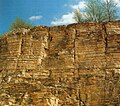
Solnhofen quarry, Obere Haardt


The stone industry is a unique feature of the Weißenburg-Gunzenhausen district in the region . The district has a share in the largest mining area for natural stone in Germany. The Jura marble , a fine-grain limestone, and the Solnhofen limestone , the world's best stone for lithography , are mined from one of the world's most important fossil deposits. Jurassic limestone is considered the most important limestone in the German construction industry. There are quarries near Weißenburg, Rothenstein , Treuchtlingen, Solnhofen and Langenaltheim. The Romans already used Solnhofen limestone in the 2nd century. So-called chopping masters work in the quarries , independent quarry workers who have now become rare and are only employed in this region. Due to the financial crisis from 2007 and the appearance of cheaper rocks from China, the sales figures for rocks from the county are falling. The "Steinreich 5" are an association of the municipalities of Langenaltheim, Solnhofen, Pappenheim and Treuchtlingen as well as Mörnsheim in the Donau-Ries district , the main mining area for the rocks.
In Pleinfeld several companies are in the sand mining business. The quartz sand mined there is known for its red color and its composition. Among other things, the Bavarian Volleyball Association is supplied with sand for beach volleyball fields. There are sand fields especially along the Swabian Rezat .
There are also deposits of oil shale , especially in the area west of Weißenburg and north of Treuchtlingen, as well as on the southwest edge of the Hahnenkamm and in the northeast of the district north of Ettenstatt.

Breweries and gastronomy
The art of brewing has a long tradition in the Weißenburg-Gunzenhausen district, which is why the region belongs to Beer Franconia . The Wurm brewery in Bieswang , which has existed since 1135, is the second oldest brewery in Franconia . The castle brewery Ellingen is the only remaining princely brewery in Franconia in the district. There are also many smaller and younger breweries , such as the Sigwart brewery in Weißenburg, Ritterbräu in Nennslingen, Felsenbräu in Thalmannsfeld , Strauss brewery in Wettelsheim and Schorsch-Bräu in Gunzenhausen. There are also around 200 restaurants in the district.
Authorities and courts

Most of the district administration's authorities are based in Weißenburg. The vehicle registration authority is one of the few district authorities to have a secondary service in Gunzenhausen. The Weißenburg employment agency is responsible for the entire district and the Roth district and has offices in Weißenburg and Gunzenhausen. The tax office is located in Gunzenhausen. The police in the district are assigned to the Ansbach police department; there are police inspections in Weißenburg, Treuchtlingen and Gunzenhausen. The Gunzenhausen police station is also responsible for carrying out water protection police tasks in the region.
In 2015, as part of the relocation of authorities to strengthen rural areas , the Bavarian state government decided to establish a state office for schools , which is to be set up in Gunzenhausen with a branch in Weißenburg from 2016, which began operations at the beginning of 2017. The examination office of the Bavarian State Ministry for Education and Culture, Science and Art , whose branch has been Gunzenhausen since 2017 , is also affiliated . In addition, the state office for non-state museums in Bavaria and the Bavarian Limes coordinator have been set up in Weissenburg as part of the relocation of the authorities. This created a total of 150 jobs.
The district court of Weißenburg i. Bay. has the district as the area of responsibility. The responsible regional court is in Ansbach, the higher regional court in Nuremberg. The competent labor court is the labor court in Nuremberg , the competent administrative court is the administrative court in Ansbach , the competent tax court is the tax court in Nuremberg and the competent social court is the social court in Nuremberg . The district belongs to the Ansbach public prosecutor's office .
Education and child care
| type of school | number | student | Teacher | Classes |
|---|---|---|---|---|
| primary school | 17th | 3122 | 202 | 149 |
| Middle school | 9 | 1727 | 135 | 87 |
| Support center | 2 | 366 | 45 | 33 |
| secondary school | 3 | 1728 | 112 | 67 |
| high school | 3 | 2158 | 156 | 63 |
| Business school | 1 | 272 | 21st | 11 |
| professional school | 2 | 1461 | 56 | 73 |
| Vocational school for special ped. advancement |
1 | 54 | 5 | 5 |
| Vocational school | 5 | 293 | 24 | 15th |
| Technical college | 1 | 631 | 39 | 25th |
| Vocational high school | 1 | 93 | 5 | 5 |
| Professional academy | 1 | 107 | 17th | 5 |
| Technical school | 3 | 106 | 0 | 5 |
Since November 15, 2013, the Weißenburg-Gunzenhausen district has had the quality seal of education region in Bavaria and can therefore call itself an educational region. The largest school in the district is the Senefelder School in Treuchtlingen with 1213 students in the 2014/2015 school year.
Schools, libraries, kindergartens
In all municipalities there are elementary schools , some middle schools , some of which cooperate in school associations . In addition to the Werner-von-Siemens-Gymnasium in Weißenburg and the Simon-Marius-Gymnasium in Gunzenhausen, there is the cooperative comprehensive school Senefelder-Schule in Treuchtlingen with secondary, secondary and high school branches. It is the only state cooperative comprehensive school in Bavaria. Gunzenhausen and Weißenburg each have a vocational school , a secondary school and several special needs schools . Weißenburg has a vocational high school with a vocational and technical college . In the vocational school center Gunzenhausen a vocational school, a business school and a master school for carpentry are combined. In Gunzenhausen there is also an agricultural school , several vocational schools and a specialist academy for social education.
The adult education centers in Gunzenhausen and Weißenburg as well as several libraries take on the educational mandate for the population. The Weissenburg City Library and the Gunzenhausen City and School Library are among the largest libraries in the district, and the Weissenburg Council Library has an important collection of early modern and medieval works . One of the 79 kindergartens and day-care centers with a total of 3855 places is a Montessori kindergarten in Weimersheim . A primary school in Weiboldshausen and the middle school in Pleinfeld also offer Montessori education. The European House in Pappenheim was a Europe-related research and educational institution for politics, cultures and languages from 2012 to 2016 .
Colleges and universities
The University of Applied Management has been located in Treuchtlingen since 2010 , a private, state-recognized university with an economic focus. The Adventure Campus Treuchtlingen is also connected as a leisure facility for students. In 2015, the Bavarian plastics campus with its technology and study center for plastics technology was opened in Weißenburg as the second university location in the district. It is jointly managed by the universities of Ansbach and Deggendorf .
The nearest universities are in Erlangen-Nuremberg , Eichstätt-Ingolstadt and Bamberg . The University of Erlangen's water sports center is located on the Großer Brombachsee near Pleinfeld.
Health and social
Clinics
The municipal company "Kliniken des Landkreis Weißenburg-Gunzenhausen" was founded in 2002 as an institution under public law and has been operating under the name Klinikum Altmühlfranken since March 2013 . With its two locations in Weißenburg and Gunzenhausen, it provides basic and standard care in the region. The Altmühlfranken Clinic has a total of 800 employees and 380 beds at both locations; 34,000 patients are treated annually, half of them inpatient and half outpatient. The clinic also operates a specialist center with six practices and a day clinic for psychiatry.
There is also a municipal hospital in Treuchtlingen, the so-called Health Center Treuchtlingen. November 2016 it was decided to convert the health center into a specialist clinic for psychosomatics in the district clinics of Middle Franconia . The geriatrics department of the Treuchtlingen hospital is relocated to Gunzenhausen.
In Gunzenhausen there is also the Altmühlseeklinik Hensoltshöhe , which is church-sponsored.
Social

In the district, several old people's homes and senior citizens' residences, workshops for the disabled and self-help groups are run by municipal and church organizations, which offer a total of 1,100 care places. Diakonie , Caritas , VdK and Arbeiterwohlfahrt have branches in the district. The rain Wagner Foundations entertain in Müssighof a regional center for the handicapped and Castle Absberg a disabled nursing home . The Diakonie Neuendettelsau maintains a deaconess mother house in Gunzenhausen, and a family center is being planned.
media
There are three daily newspapers in the Weißenburg-Gunzenhausen district: the Weißenburger Tagblatt , the Altmühl-Boten and the Treuchtlinger Kurier ; all are local editions of the Nürnberger Nachrichten . While the Altmühl-Bote covers the area of the former Gunzenhausen district including some communities in today's Ansbach district, the Weißenburger Tagblatt is read in the northern half of the former Weißenburg district and the Treuchtlinger Kurier in the southern half. In addition, various advertising papers appear weekly, including the Weißenburg city newspaper . The culture magazine carpe diem reports on the culture and nightlife in the district.
In addition to the Bavarian and national radio stations, the radio can also receive the Ansbacher program Radio 8 and some Nuremberg programs and on television, in addition to the public Bavarian television, the private stations Franken Fernsehen and intv - the infokanal can be received. The telecom serves the telecommunications tower Burgsalach east of Indian book , the 158 meters to the highest telecommunication towers of the Deutsche Funkturm GmbH belongs.
traffic


Rail transport
The state-run Ludwigs-Süd-Nord-Bahn opened the Pleinfeld – Gunzenhausen – Cronheim –Nördlingen section of the Nuremberg – Augsburg line in 1849 . The city of Ansbach built a connecting line to Gunzenhausen in 1859 at its own expense , which the Bavarian State Railways extended to Treuchtlingen in 1869. At the same time, the direct connection from Pleinfeld via Weißenburg to Treuchtlingen was established, which was continued in 1870 through the Altmühltal to Eichstätt and Ingolstadt . A branch line from Weißenburg to Nennslingen , required from the end of the 19th century, was never realized for financial reasons. In 1925, the Pleinfeld sand railway was put into operation. Until 1964, sand was brought from the local sand pits along this route to a loading ramp at Pleinfeld station.
The main railways Ingolstadt – Treuchtlingen and Treuchtlingen – Würzburg , Donauwörth – Treuchtlingen and Treuchtlingen – Nuremberg as well as the branch line Nördlingen – Pleinfeld run through the district, from Gunzenhausen to Pleinfeld in passenger traffic (Seenlandbahn) and from Nördlingen to Gunzenhausen (Hesselbergbahn) only in freight traffic is driven on. People are only transported on this route between Nördlingen and Gunzenhausen on special trips with museum trains . A partial recommissioning of the route for local rail passenger transport to Wassertrüdingen is planned.
The city of Treuchtlingen is one of the most important railway hubs in Bavaria. The city's train station is still a bottleneck for interregional freight traffic. It has lost importance in long-distance traffic due to the high-speed line Nuremberg – Ingolstadt – Munich . There are ten train stations in the district (see train stations in the Weißenburg-Gunzenhausen district ).
The district's route network covers a total of 80 kilometers, 17 kilometers of which are single-track. Almost half of the district's population lives within a three-kilometer radius of a train station.
Road traffic
In addition to the districts of Cham , Donau-Ries and Kronach , the district of Weißenburg-Gunzenhausen is one of four Bavarian districts without their own motorway access. The most important traffic axes are mainly federal roads as well as district and municipal roads . The expansion of federal highway 2 and the connection of the district to federal highway 9 are considered necessary structural improvement measures . A dense network of state and district roads runs through the district (see list of district roads in the Weißenburg-Gunzenhausen district ). The route network of the Weißenburg-Gunzenhausen district comprises a total of 108 kilometers of federal roads, 204 kilometers of state roads and 284 kilometers of district roads. At the beginning of 2018 there were a total of 82,089 registered vehicles in the district, including 60,205 cars.
Bundesstrasse 2
The most important north-south connection in the district is the partly four- and three-lane federal highway 2 (B 2), which leads from Nuremberg into the district. The Roth motorway junction of the A 6 connects the district to the A 73 and A 9 .
The northernmost point of the B 2 in the district is north of Mischelbach . It leads past Pleinfeld and Ellingen and takes the B 13 there, with which it leads to the Weißenburg-Mitte junction. South of Weißenburg, the federal highway crosses Dettenheim and Dietfurt and passes Treuchtlingen. Your southernmost point in the district is Mauthaus . From there it continues to Donauwörth . Further road connections exist to Augsburg and in the direction of Allgäu . In the south there is a connection to the A 8 and A 96 motorways .
Parts of the economy are calling for a four-lane expansion of the B 2.
Bundesstrasse 13

The federal highway 13 (B 13), which crosses the Autobahn 6 near Ansbach , reaches the district near Muhr am See. Shortly afterwards, near Gunzenhausen, there is a short joint route with the B 466 to bypass the city. The B 13 then crosses the villages of Unterasbach , Dornhausen , Theilenhofen and Stopfenheim . West of Ellingen it joins the B 2 with a joint four-lane route. The joint route ends at the Weißenburg-Mitte junction, where the B 13 leaves Weißenburg in the direction of Eichstätt . From there it goes to Rothenstein , the southeasternmost point of the B 13 in the district. The neighboring district town of Eichstätt is about 15 kilometers away and Ingolstadt in Upper Bavaria is about 50 kilometers away. There is a connection to the A 9 and in the direction of Eastern Bavaria.
Bundesstrasse 466

The federal highway 466 (B 466), which joins the district from Schwabach , leads through Obererlbach , the northernmost point of the federal highway in the district, in the direction of Gunzenhausen. There is a short joint route with the B 13 to bypass the town. After leaving the shared route, the B 466 leads through Gnotzheim, Ostheim and Westheim towards Oettingen in the neighboring district of Donau-Ries. The southernmost point of the federal road in the district is not far from Pagenhard . From Oettingen and Nördlingen there is a connection to the A 7 (Kempten-Ulm-Würzburg) with the Aalen- Westhausen connection via the federal highways 25 and 29 .
Planned federal highway 131n
The planned new federal highway 131 (B 131n) is to represent the connection between the motorways 7 and 9 in the final stage and thus give the district its own motorway connection. The idea of this road connection was born in 2000 to improve the development of the district and the Franconian Lake District. Many committees see no chance of this and are advocating the expansion of existing roads. Parts of the population of the neighboring district of Roth are against the project.
Transportation
Local public transport has been operated since 1997 by the Verkehrsverbund Großraum Nürnberg (VGN), the largest transport association in Bavaria and one of the largest in Germany. The district forms the southernmost part of the transport association. In the Weißenburg-Gunzenhausen district there are 41 public bus routes with around 208 million kilometers of usable space every year . Urban public transport in Gunzenhausen and Weißenburg is handled by its own city bus networks. The district takes part in the BOB campaign against alcohol-driving. There are also collective call taxis (AST).
air traffic

The nearest commercial airport is Nuremberg Airport . In the district there are at Reutberg the 1952 opened airfield Gunzenhausen-Reutberg and Bubenheim the 1961 opened airfield Treuchtlingen-Bubenheim . The Weißenburg-Wülzburg glider airfield of the local gliding club is located above Weißenburg. The district is the center of the military " low flight area No. 7", with the exception of the city centers of Gunzenhausen, Treuchtlingen and Weißenburg.
Shipping
There are no federal waterways through the Weißenburg-Gunzenhausen district , as no river in the region is suitable for shipping. There are several sailing facilities on the Brombachsee and Altmühlsee; Germany's largest inland sailing port is located near Ramsberg. The closest economically important port is the Roth port .
For tourist purposes, the MS Brombachsee , a trimaran that is unique in Europe with its architecture and construction, runs between the Ramsberg , Absberg, Enderndorf , Allmannsdorf and Pleinfeld piers during the summer months . A second shipping line exists on the Altmühlsee, where the MS Altmühlsee connects Gunzenhausen, the surf center, Muhr am See, Wald and the Shepherd's Island .
License Plate
On May 2, 1973, the district was assigned the WUG, which had been valid since July 1, 1956 in the old district of Weißenburg in Bavaria . Since July 10, 2013 the license plate GUN (Gunzenhausen) has been available again as part of the license plate liberalization . The theoretically possible EIH , HIP and DON labels were not reintroduced in the Weißenburg-Gunzenhausen district.
Awards (selection)
The district of Weißenburg-Gunzenhausen has won numerous prizes and awards as a municipality. These included:
- Municipality of the year 2017 as a special category of the German SME Award
- Recognition as a LEADER region in 2015
Communities
(Population figures as of December 31, 2019)
Other communities
|
 
|
See also
- List of communities in the Weißenburg-Gunzenhausen district
- List of places in the district of Weißenburg-Gunzenhausen
literature
- Sigrid Rabinger: Weissenburg-Gunzenhausen district: History-certificates-information , Manz, 1984. ISBN 3-7863-0955-8
- Konrad Spindler (Ed.): Weissenburg-Gunzenhausen District - Archeology and History , Theiss, 1987
- Konrad Spindler (ed.): Weissenburg-Gunzenhausen district - monuments and sites , Theiss, 1987
- Hanns Hubert Hofmann : Gunzenhausen-Weißenburg . In: Historical Atlas of Bavaria , part of Franconia . Series I, Issue 8. Komm. Für Bayerische Landesgeschichte, Munich 1960, DNB 452071089 ( digitized version ).
- Friedrich Bernward Fahlbusch : Weissenburg. Becoming and growing a small Franconian town , in: Yearbook for Franconian State Research 48 (1988) 19–38
- Gotthard Kießling (Ed.): Weissenburg-Gunzenhausen district. Ensembles, architectural monuments, archaeological monuments , Lipp, Munich 2000
- Weissenburg-Gunzenhausen district office: Statistics altmühlfranken 2014. Selected economic and structural data for the Weißenburg-Gunzenhausen district. Figures, data, facts , Weißenburg 2014
- Stefanie Fischer: Economic trust and anti-Semitic violence. Jewish cattle dealers in Middle Franconia 1919–1939 , Wallstein, Göttingen 2014. ISBN 978-3-8353-1239-5
- Arthur Rosenbauer ; Forgotten secrets - rediscovered. Mining in the Altmühltal Nature Park between Altmühl, Anlauter and Danube ; wek-Verlag : Treuchtlingen / Berlin 2010; ISBN 978-3-934145-81-8
- Arthur Rosenbauer; Caves, grottos and sinkholes. Fascinating world underground, Altmühlfranken region ; wek-Verlag: Treuchtlingen / Berlin 2010; ISBN 978-3-934145-87-0
Web links
- Official website
- Map of the Weißenburg-Gunzenhausen district on: BayernAtlas of the Bavarian State Government ( information )
- Literature from and about the Weißenburg-Gunzenhausen district in the catalog of the German National Library
- Entry on the coat of arms of the Weißenburg-Gunzenhausen district in the database of the House of Bavarian History
Individual evidence
- ↑ "Data 2" sheet, Statistical Report A1200C 202041 Population of the municipalities, districts and administrative districts 1st quarter 2020 (population based on the 2011 census) ( help ).
- ^ Hanns Hubert Hofmann : Gunzenhausen-Weißenburg . In: Historical Atlas of Bavaria , part of Franconia . Series I, Issue 8. Komm. Für Bayerische Landesgeschichte, Munich 1960, DNB 452071089 , p. 19 ( digitized version ).
- ↑ Altmühlfranken , www.altmuehlfranken.de, Weißenburg-Gunzenhausen district, accessed on April 11, 2015
- ↑ a b c d e f Topographic Maps , BayernAtlas , Bavarian Surveying Administration
- ↑ Calculated using a computer at Robert Heret: Difference between Central European time and local time , www.heret.de , accessed on June 25, 2015
- ^ Geodetic reference point Gunzenhausen ( Memento from September 8, 2015 in the Internet Archive ), Bavarian Surveying Administration, accessed on August 16, 2015
- ^ A b Franz Tichy: Geographical land survey: The natural spatial units on sheet 163 Nuremberg . Federal Institute for Regional Studies, Bad Godesberg 1973.? Online map (PDF; 4 MB)
- ^ Franz Tichy: Geographical land survey: The natural space units on sheet 172 Nuremberg. Federal Institute for Regional Studies, Bad Godesberg 1973. → Online map (PDF; 4 MB)
- ↑ Map services of the Federal Agency for Nature Conservation ( information )
- ^ Homepage of the town of Auernheim, accessed on April 6, 2015
- ↑ a b c District Office Weißenburg-Gunzenhausen: Statistics altmühlfranken 2014. Selected economic and structural data of the district Weißenburg-Gunzenhausen. Numbers, data, facts . Weißenburg 2014, p. 12
- ↑ a b c rivers and lakes of the district as well as the course of the European main watershed. (PDF; 412 kB) Middle Franconia , accessed on February 13, 2012 .
- ^ District office Weißenburg-Gunzenhausen: Statistics altmühlfranken 2014. Selected economic and structural data of the district of Weißenburg-Gunzenhausen. Numbers, data, facts. Weißenburg 2014, p. 15
- ↑ Altmühl- und Brombachsee: Kampfansage an Algen in: Altmühl-Bote , nordbayern.de , published on February 1, 2011, accessed on April 6, 2015
- ↑ The landscape of the large district town of Weißenburg i. Bay. , accessed April 29, 2015
- ^ A b Hanns Hubert Hofmann : Gunzenhausen-Weißenburg . In: Historical Atlas of Bavaria , part of Franconia . Series I, Issue 8. Komm. Für Bayerische Landesgeschichte, Munich 1960, DNB 452071089 , p. 51 ( digitized version ).
- ↑ Map of the potential natural vegetation in Germany and the surrounding area ( Memento of the original from April 26, 2015 in the Internet Archive ) Info: The archive link was automatically inserted and not yet checked. Please check the original and archive link according to the instructions and then remove this notice. at Floraweb. Published by the Federal Agency for Nature Conservation . Retrieved June 25, 2015
- ↑ Historical fruit varieties - planting plan ( Memento from March 16, 2016 in the Internet Archive ), Obstarche in Spielberg, accessed on January 17, 2016
- ↑ Entire species list , www.lebensraum-buchleite.de, accessed on January 17, 2016
- ↑ Biberberatung ( Memento from July 10, 2015 in the Internet Archive ), www.landkreis-wug.de, accessed on April 16, 2015
- ↑ Bird observations at Altmühlsee in March 2015 ( Memento from July 9, 2015 in the Internet Archive ), State Association for Bird Protection in Bavaria (PDF)
- ↑ Sandwege , Sandachse Franken, accessed on April 16, 2015
- ^ Stefan Glaser, Gerhard Doppler and Klaus Schwerd (Red.): GeoBavaria. 600 million years of Bavaria. International edition. Bavarian Geological State Office , Munich 2004 ( online ), p. 26
- ↑ a b Stefan Glaser, Gerhard Doppler and Klaus Schwerd (Red.): GeoBavaria. 600 million years of Bavaria. International edition . Bavarian Geological State Office , Munich 2004 ( online ), p. 40 ff
- ^ Map , geotopes in the Weissenburg-Gunzenhausen district, Bavarian State Office for the Environment , accessed on April 6, 2015
- ↑ Markus Moser: Plateosaurus engelhardti Meyer , 1837 (Dinosauria: Sauropodomorpha) from the Feuerletten (Middle Keuper; Upper Triassic) of Bavaria . Zitteliana, Series B: Treatises of the Bavarian State Collection for Paleontology and Geology. Vol. 24, 2003, pp. 3–186, urn : nbn: de: bvb: 19-epub-12711-3
- ↑ Earthquake zone query at the Helmholtz Center Potsdam - German Research Center for Geosciences , accessed on August 16, 2015
- ↑ Calculated from the information on the website of the Central Franconia administrative region (accessed on November 6, 2013)
- ↑ Topographic map of the Ries Geopark ( online ( Memento from September 12, 2015 in the Internet Archive ))
- ↑ Overview of the FFH areas in Bavaria ( Memento from September 30, 2007 in the Internet Archive ) (PDF; 49 kB)
- ↑ Rare, beautiful and valuable: Treasures of nature , www.altmuehlfranken.de, Weißenburg-Gunzenhausen district, accessed on April 11, 2015
- ↑ project areas of sand axis francs , sand axis francs, accessed on July 5, 2015
- ↑ Green List of Landscape Protection Areas in Bavaria (PDF; 1.1 MB)
- ↑ Map of the bird sanctuaries ( memento of the original from March 4, 2016 in the Internet Archive ) Info: The archive link was automatically inserted and not yet checked. Please check the original and archive link according to the instructions and then remove this notice. : Middle Franconia , map of the European bird sanctuaries in the administrative region of Middle Franconia, accessed on April 16, 2015
- ↑ About us: Committed to nature ( Memento from February 19, 2012 in the Internet Archive ), Altmühltal Nature Park, accessed on April 6, 2015
- ↑ a b c d e Weissenburg-Gunzenhausen district: Official statistics of the LfStat
- ↑ Spatial structure: Map 1 (PDF; accessed April 6, 2015)
- ↑ a b District Office Weißenburg-Gunzenhausen: Press release no .: 52/2014, April 10, 2014
- ↑ a b http://www.mittelstandspreis.com/wettbewerb/single-newsmeldung/archive/2017/september/30/article/kommune-des-jahres-2017-aus-bayern.html (link not available)
- ^ The INSM profile: Landkreis Weißenburg-Gunzenhausen ( Memento from September 24, 2015 in the Internet Archive ), INSM , accessed on August 1, 2015
- ↑ Where is it best to live? The great Germany study . In: ZDF.de. Retrieved August 22, 2019
- ↑ Police Headquarters Middle Franconia : Criminal Statistics 2014 , Ainring 2015, p. 42
- ↑ Markus Steiner: Fewer accidents, more injuries . In: Weißenburger Tagblatt. Published March 9, 2017, accessed March 9, 2017
- ^ District office Weißenburg-Gunzenhausen: Statistics altmühlfranken 2014. Selected economic and structural data of the district of Weißenburg-Gunzenhausen. Numbers, data, facts . Weißenburg 2014, p. 32
- ↑ Information, data and facts about the Weißenburg-Gunzenhausen district on baylink.de . Retrieved February 14, 2012 .
- ^ District office Weißenburg-Gunzenhausen: Statistics altmühlfranken 2016. Selected economic and structural data of the district of Weißenburg-Gunzenhausen. Numbers, data, facts . Weißenburg 2016, p. 34
- ↑ Weissenburg-Gunzenhausen district: Education in Altmühlfranken 2014/2015. Education report for the Weißenburg-Gunzenhausen district, as of July 2015 , p. 4
- ↑ Weissenburg-Gunzenhausen district: Education in Altmühlfranken 2014/2015. Education report for the Weißenburg-Gunzenhausen district. As of July 2015 , p. 15
- ^ District office Weißenburg-Gunzenhausen: Statistics altmühlfranken 2017. Selected economic and structural data of the district of Weißenburg-Gunzenhausen. Numbers, data, facts . Weißenburg 2017, pp. 35–37
- ↑ Maps on the history of Bavaria: Predominantly Protestant and predominantly Catholic areas in Franconia . In: Kirmeier, Josef u. a. (Ed.): 200 years of Franconia in Bavaria . Volume of essays for the state exhibition 2006, Augsburg 2006 (publications on Bavarian history and culture 51), see House of Bavarian History
- ↑ Directory of parishes in Bavaria with a predominantly Catholic or Protestant population ( Memento of the original from May 20, 2011 in the Internet Archive ) Info: The archive link was automatically inserted and not yet checked. Please check the original and archive link according to the instructions and then remove this notice. of the Bavarian State Office for Statistics and Data Processing, accessed on April 6, 2015
- ↑ Law on the Protection of Sundays and Holidays (PDF; 22 kB)
- ↑ Islamism in Bavaria - Small Towns in Fear , Süddeutsche Zeitung , published on May 17, 2010
- ↑ a b District Office Weissenburg-Gunzenhausen: Statistics altmühl franken 2014. Selected Economic and structural data of the district Weißenburg-Gunzenhausen. Numbers, data, facts . Weißenburg 2014, p. 36
- ^ University of Weissenburg: Technology transfer center is coming , www.nordbayern.de, published in the Weißenburger Tagblatt on November 10, 2011
- ↑ Bavarian State Office for Statistics and Data Processing: Regionalized population projection for Bavaria until 2032. Demographic profile for the Weißenburg-Gunzenhausen district , Munich 2014, p. 9
- ↑ Population in Altmühlfranken remains stable , Weißenburger Tagblatt, in: nordbayern.de. Published December 30, 2016. Retrieved December 30, 2016
- ↑ a b c d page no longer available , search in web archives: Bavarian State Office for Statistics and Data Processing - Directory of the officially named parts of the municipality, as of July 31, 2005 (XLS; 5.9 MB)
- ^ District office Weißenburg-Gunzenhausen: Statistics altmühlfranken 2017. Selected economic and structural data of the district of Weißenburg-Gunzenhausen. Numbers, data, facts . Weißenburg 2017, p. 19
- ↑ a b c d Hanns Hubert Hofmann : Gunzenhausen-Weißenburg . In: Historical Atlas of Bavaria , part of Franconia . Series I, Issue 8. Komm. Für Bayerische Landesgeschichte, Munich 1960, DNB 452071089 , p. 53-54 ( digitized version ).
- ^ Hanns Hubert Hofmann : Gunzenhausen-Weißenburg . In: Historical Atlas of Bavaria , part of Franconia . Series I, Issue 8. Komm. Für Bayerische Landesgeschichte, Munich 1960, DNB 452071089 , p. 82-83 ( digitized version ).
- ↑ For the classification of a municipality in a large, medium- sized and small town as well as a rural municipality, see Ongoing city observation - spatial delimitations. City and community types in Germany , Federal Institute for Building, Urban and Spatial Research . Retrieved May 2, 2020.
- ^ Weissenburg-Gunzenhausen . In: citypopulation.de. Retrieved May 2, 2020.
- ↑ An introduction to the subject of Neolithization in Bavaria that is understandable for laypeople is provided by How the Bavarian Farmers Were Made - The Neolithic Age on the Archäologie am Obermain website
- ^ Konrad Spindler: Weissenburg-Gunzenhausen district. Monuments and sites , Vol. 2, Stuttgart 1987, p. 146
- ↑ Konrad Spindler (edit.): Guide to archaeological monuments in Germany, Volume 14: Landkreis Weißenburg-Gunzenhausen - Archeology and History . Konrad Theiss Verlag, Stuttgart 1987, pp. 203-204
- ↑ Hans-Peter Uenze, Claus-Michael Hüssen: Pre- and early history . In: Handbuch der Bayerischen Geschichte, greeted by Max Spindler, 3rd volume, 1st part: History of Franconia up to the end of the 18th century, re-edited by Andreas Kraus, 3rd, revised edition, Munich 1997, p. 3–46, here p. 13
- ↑ Birgit Lißner: On the Early Bronze Age Groups in Southern Germany , Leipzig 2004, p. 4
- ↑ a b Heinrich Eidam: A prehistoric fortification on the Gelben Bürg near Dittenheim . In the correspondence sheet of the German Society for Anthropology, Ethnology and Prehistory . Vol. 43, 1912, p. 140
- ↑ Cordula Nagler-Zanier: Ring jewelery from the Hallstatt period from Bavaria , Franz Steiner, Stuttgart 2005, p. 46
- ^ Hanns Hubert Hofmann : Gunzenhausen-Weißenburg . In: Historical Atlas of Bavaria , part of Franconia . Series I, Issue 8. Komm. Für Bayerische Landesgeschichte, Munich 1960, DNB 452071089 , p. 20 ( digitized version ).
- ^ Konrad Spindler (Ed.): Weissenburg-Gunzenhausen district. Archeology and History , Theiss, Aalen 1987, p. 87
- ↑ Local history of the Westheim community , accessed on July 13, 2015
- ↑ Jan Stephan: Everyday Life in a Roman Border Town , in: Archeology in Germany 02 | 2017, p. 68 f., Here p. 68
- ↑ Its text was published here: Wilhelm von Christ: Römisches Militärdiplom , in: Session reports of the Royal Bavarian Academy of Sciences , parts 1–2, JG Weiss, Munich 1868, pp. 409–447, here pp. 415–418
- ^ Wilhelm von Christ: Roman Military Diploma, in: Session reports of the Royal Bavarian Academy of Sciences , Parts 1–2, JG Weiss, Munich 1868, pp. 409–447, here p. 410
- ^ A b Hans-Peter Uenze, Claus-Michael Hüssen: Pre- and early history . In: Handbuch der Bayerischen Geschichte, greeted by Max Spindler, 3rd volume, 1st part: History of Franconia up to the end of the 18th century, re-edited by Andreas Kraus, 3rd, revised edition, Munich 1997, p. 3–46, here p. 44
- ↑ Wilfried Menghin: Foundation: The early Middle Ages . In: Handbuch der Bayerischen Geschichte, greeted by Max Spindler, 3rd volume, 1st part volume. History of Franconia up to the end of the 18th century , re-edited by Andreas Kraus, 3rd revised edition, Munich 1997, pp. 47–69, here p. 50
- ↑ Robert Reiss: The Merovingian Period Cemetery in Westheim (Kr. Weißenburg-Gunzenhausen) , Nuremberg 1994
- ^ Wilhelm Störmer : The Baiuwaren. From the Great Migration to Tassilo III . Beck, Munich 2002, p. 33
- ↑ Marcus Beck and Claudia Merthen: Between Hain and Himmelreich - The row graves of Weissenburg . Publication series of the Frankenbund group Weißenburg, issue 4. 2013
- ^ Heiko Steuer : Thuringians and Bavarians - Location in space and time and social relations , in: Janine Fries-Knoblach, Heiko Steuer, John Hines (eds.): The Baiuvarii and Thuringi. An Ethnographic Perspective , Boydell & Brewer, Woodbridge 2014, pp. 111–147, here p. 114
- ^ Hanns Hubert Hofmann : Gunzenhausen-Weißenburg . In: Historical Atlas of Bavaria , part of Franconia . Series I, Issue 8. Komm. Für Bayerische Landesgeschichte, Munich 1960, DNB 452071089 , p. 21 ( digitized version ).
- ^ Hanns Hubert Hofmann : Gunzenhausen-Weißenburg . In: Historical Atlas of Bavaria , part of Franconia . Series I, Issue 8. Komm. Für Bayerische Landesgeschichte, Munich 1960, DNB 452071089 , p. 23 ( digitized version ).
- ^ A b Friedrich Bernward Fahlbusch: Weissenburg . In: Lexicon of the Middle Ages (LexMA). Volume 8, LexMA-Verlag, Munich 1997, ISBN 3-89659-908-9 , Sp. 2139.
- ^ Wilhelm Störmer: The inner development: State, society, church, economy . In: Handbuch der Bayerischen Geschichte, greeted by Max Spindler, 3rd volume, 1st part volume: History of Franconia up to the end of the 18th century , newly published by Andreas Kraus, 3rd, revised edition, Munich 1997, p 210-330, here p. 254 f
- ^ Elisabeth Vogl: Fossa Carolina and Ludwigs-Danube-Main Canal. Ground monument and monument street . in: Nordgau-Festschriften of the Oberpfälzer Kulturbund, here pp. 65–66
- ^ Ralf Molkenthin: Streets of water. Technical, economic and military aspects of inland navigation in Central Europe in the early and high Middle Ages . LIT Verlag, Münster 2006, ISBN 3-8258-9003-1 , p. 54-81 .
- ^ Yearbook of the Historical Association for Middle Franconia, Volumes 48–49, 1988, p. 33
- ↑ On the medieval city history cf. Peter Friedrich Haberkorn: Weissenburg in Bavaria: Stations in its history from the central Roman town to the late medieval imperial city , Diss., Mammendorf 1996
- ^ Hanns Hubert Hofmann : Gunzenhausen-Weißenburg . In: Historical Atlas of Bavaria , part of Franconia . Series I, Issue 8. Komm. Für Bayerische Landesgeschichte, Munich 1960, DNB 452071089 , p. 33 ( digitized version ).
- ^ Gunzenhausen district, Munich / Assling 1966, p. 202
- ^ Richard Kölbel: The first margrave war 1449-1453 , in: Communications of the Association for the History of the City of Nuremberg 65 (1978) 91-123
- ↑ So named by Karl Weller : Die Nibelungenstraße , in: Zeitschrift für Deutsches Altertum und Deutsche Literatur 70 (1933) 49-66 ( Rudolf Endres : The functional change of the trade fair city of Nördlingen and the imperial cities of Dinkelsbühl and Rothenburg , in: Franz Tichy, Jürgen Schneider: Urban structures on old trade routes in functional change up to the present day , Degener, Neustadt ad Aisch 1984, p. 15–27, here p. 16)
- ↑ a b c Alemannia Judaica : Treuchtlingen - Jewish history / synagogue . Retrieved April 11, 2015
- ↑ a b History up to 1933 , Jewish life in Gunzenhausen
- ^ C. Scott Dixon: The Reformation and Rural Society. The Parishes of Brandenburg-Ansbach-Kulmbach, 1528-1603 , Cambridge University Press, 1996, p. 5
- ^ Alfred Wendehorst : The diocese of Eichstätt. The series of bishops until 1535 , Walter de Gruyter, 2006, pp. 252–255
- ↑ Wolfgang Behringer: witch hunt in Bavaria. Folk magic, zeal for faith and reasons of state in the early modern times , Oldenbourg, Munich 1997, p. 154: "The Council of Weißenburg was literally blackmailed by the Teutonic Order of Ellingen and was forced to go to a witch trial in which two women were finally executed."
- ↑ Places of execution : Map Franken on hexen-franken.de, accessed on April 18, 2015
- ^ A b c Hanns Hubert Hofmann : Gunzenhausen-Weißenburg . In: Historical Atlas of Bavaria , part of Franconia . Series I, Issue 8. Komm. Für Bayerische Landesgeschichte, Munich 1960, DNB 452071089 , p. 41 ( digitized version ).
- ↑ Joachim Bahlcke (ed.): Religious refugees. Causes, forms and effects of early modern denominational migration in Europe , LIT Verlag, Münster, 2008, p. 231
- ^ Barbara Dölemeyer: Legal aspects of denominational migration in early modern Europe using the example of the Huguenot acceptance , in: Joachim Bahlcke (Ed.): Glaubensflüchtlinge. Causes, forms and effects of early modern denominational migration in Europe , LIT Verlag, Münster, 2008, pp. 1–25, here p. 4
- ^ Konrad Spindler: Weißenburger Linie (Guide to archaeological monuments in Germany, Vol. 15: Landkreis Weißenburg-Gunzenhausen - Monuments and Fundstätten , Theiss, Stuttgart 1987, pp. 28-32.)
- ^ Rudolf Endres: Der Fränkische Reichskreis , In: Hefte zur Bayerischen Geschichte und Kultur 29 , published by the House of Bavarian History, Regensburg 2003, p. 38, see online version (PDF)
- ↑ Michael Puchta: Mediatization 'with skin and hair, body and life'. The submission of the Imperial Knights by Ansbach-Bayreuth (1792–1798) , Vandenhoeck & Ruprecht, 2012, passim
- ↑ Synagogues in Bavaria - overview, Middle Franconia , alemannia-judaica, from there visit the individual communities
- ↑ Johannes Merz: Herzogswürde, Franconian . In: Historical Lexicon of Bavaria
- ^ Prussia in Franconia 1792–1806 , material from the 1999 state exhibition of the House of Bavarian History
- ^ Riedel Verlag (Ed.): Memorials for Peace. Memorials in the district of Weißenburg-Gunzenhausen 1914 to 1918 and 1939 to 1945. Gunzenhausen 1988
- ↑ Werner Falk: An early hatred of Jews , in: Nürnberger Nachrichten , March 25, 2009
- ↑ Gunnar Beutner: "What do we need an order if it goes against the Jews?" The Gunzenhausen pogrom 1934 , Antogo, Nürnberg 2006, p. 17
- ^ Sieghard Hedwig: Heavy bombing raid on Treuchtlingen 68 years ago , Treuchtlinger Kurier, nordbayern.de, from February 22, 2013, accessed on April 14, 2015
- ↑ Under the Nazi regime , Jewish life in Gunzenhausen
- ^ Ordinance on the reorganization of Bavaria into rural districts and independent cities of December 27, 1971
- ^ Federal Statistical Office (ed.): Historical municipality directory for the Federal Republic of Germany. Name, border and key number changes for municipalities, counties and administrative districts from May 27, 1970 to December 31, 1982 . W. Kohlhammer GmbH, Stuttgart and Mainz 1983, ISBN 3-17-003263-1 , p. 730 .
-
↑ Bavarian State Statistical Office (ed.): Official city directory for Bavaria, territorial status on October 1, 1964 with statistical information from the 1961 census . Issue 260 of the articles on Bavaria's statistics. Munich 1964, DNB 453660959 , Section II, Sp. 783 ( digitized version - Gunzenhausen district). Bavarian State Statistical Office (publisher): Official place directory for Bavaria, territorial status on October 1, 1964 with statistical information from the 1961 census . Issue 260 of the articles on Bavaria's statistics. Munich 1964, DNB 453660959 , Section II, Sp.
831 ( digitized version - Weißenburg i. Bay. District). - ↑ Thomas Biller: Die Wülzburg: Architectural History of a Renaissance Fortress , Munich, 1996, p. IX
- ↑ Muhr and the robbers by Friedrich Schiller - A parallel thought to be impossible is reality ( Memento from October 2, 2013 in the Internet Archive ) (PDF; 81 kB)
- ↑ Johann Schrenk; Karl Friedrich Zink: God's houses: Church leaders in the district of Weißenburg-Gunzenhausen , Treuchtlingen / Berlin 2008, book cover
- ^ Episcopal deanery Weißenburg-Wemding: Pilgrimage sites in the deanery Weißenburg-Wemding. Archived from the original on March 9, 2013 ; accessed on November 27, 2015 .
- ^ Heinrich W. Mangold: The St. Gallus Church in Pappenheim (PDF; 478 kB)
- ↑ Christine Riedl-Valder: Solnhofen - place of work of the Franconian saint Sola , in: Monasteries in Bavaria , House of Bavarian History
- ^ Evangelical Lutheran. Church of St. Marien and Christophorus in Absberg . Pointoo.de. Archived from the original on February 21, 2015. Info: The archive link was automatically inserted and has not yet been checked. Please check the original and archive link according to the instructions and then remove this notice. Retrieved April 8, 2015.
- ↑ The Palm Donkey from Kalbensteinberg (PDF; 985 kB)
- ↑ Hidden Treasures. Nürnberger Nachrichten , archived from the original on November 5, 2013 ; Retrieved April 8, 2015 .
- ↑ a b Weißenburg in Bayern , Bavarian Monument List , Bavarian State Office for Monument Preservation (PDF)
- ↑ From the chronicle of the market in Nennslingen: The Jura house. Retrieved May 8, 2016 .
- ↑ TSV 1860 Weißenburg ( Memento from September 27, 2015 in the Internet Archive ) on fussballdaten.de , accessed on April 15, 2015
- ↑ www.eagle-cat.de , homepage, accessed on May 16, 2015
- ↑ Manfred E. Fritsche: "Segelflug": With the foil catamaran over the Altmühlsee. In: nordbayern.de. April 21, 2015, accessed July 5, 2015 .
- ↑ The new sports facility is inaugurated , Friedrich-Alexander-Universität Erlangen-Nürnberg , July 21, 2003, accessed on July 4, 2015
- ↑ Firefighting , www.landkreis-wug.de, Weißenburg-Gunzenhausen district, accessed on April 15, 2015
- ↑ Chronicle of the Gunzenhausen Volunteer Fire Brigade, accessed on April 15, 2015
- ^ History of the Weissenburg Volunteer Fire Brigade , accessed on April 15, 2015
- ↑ 116 sports clubs with 36,600 members in the BLSV group . In: nordbayern.de. Published online January 9, 2019. Accessed January 10, 2019.
- ^ Museum search ( Memento from July 11, 2015 in the Internet Archive ), Museums in Bavaria
- ↑ Heimat- u. Pleinfeld Brewery Museum ( Memento from January 8, 2012 in the Internet Archive ), Markt Pleinfeld, accessed on April 8, 2015
- ^ Homepage of the East Prussia Cultural Center , accessed on April 8, 2015
- ^ Folklore Museum Treuchtlingen , accessed on April 12, 2015
- ↑ Die Kirchweisau von Solnhofen , www.altmuehlfranken.de, rural district Weißenburg-Gunzenhausen, accessed on April 12, 2015
- ↑ Dance around the Chicken Tree , www.altmuehlfranken.de, Weißenburg-Gunzenhausen district, accessed on April 12, 2015
- ^ The folk festival in Treuchtlingen , www.altmuehlfranken.de, Weißenburg-Gunzenhausen district, accessed on April 12, 2015
- ↑ From a special supplement to WZ on August 17, 2011
- ↑ A spicy and crispy Altmühlfränkin , www.altmuehlfranken.de, Weißenburg-Gunzenhausen district, accessed on June 27, 2015
- ↑ Federal competition "Our village should be more beautiful - our village has a future". Results 1961–2013 (PDF; 58 kB)
- ↑ Talking Language Atlas of Bavaria , Bayerische Landesbibliothek Online, accessed on May 17, 2015
- ↑ Markus Steiner: Village saves dialect . in: Weißenburger Tagblatt , published on May 31, 2014 ( available online ; accessed on June 21, 2016)
- ^ Alemannia Judaica : Weissenburg in Bavaria (Weissenburg-Gunzenhausen district) - Jewish history / synagogue . Retrieved April 11, 2015
- ↑ Memorial sites for the victims of National Socialism. A documentation, Volume 1 . Federal Agency for Civic Education, Bonn 1995, p. 195 (Treuchtlingen); P. 144 (Gunzenhausen)
- ↑ Gerhard Wägemann is the new district administrator of the Weißenburg-Gunzenhausen district , nordbayern.de, accessed on April 13, 2015
- ^ Website of the District Office
- ↑ Directions & contact . Weissenburg-Gunzenhausen district. Retrieved May 24, 2019
- ^ District office Weißenburg-Gunzenhausen . In: www.Behördenwegweiser.de. Retrieved May 24, 2019
- ↑ Debt ranking of the 295 districts in Germany , report from August 3, 2014, accessed on April 21, 2015
- ↑ Robert Maurer: Clear approval for the district budget . In: Weißenburger Tagblatt, online at nordbayern.de on December 19, 2019. Accessed on December 19, 2019.
- ^ A b Rudolf Sponsel: The debt portrait of the Weißenburg-Gunzenhausen district , Internet publication for general and integrative psychotherapy, accessed on July 11, 2015
- ↑ Evaluation of all 27 municipalities in the district under Statistics Municipal ( Memento of the original from July 13, 2015 in the Internet Archive ) Info: The archive link was inserted automatically and has not yet been checked. Please check the original and archive link according to the instructions and then remove this notice. , Bavarian State Office for Statistics
- ^ District office Weißenburg-Gunzenhausen: Statistics altmühlfranken 2016. Selected economic and structural data of the district of Weißenburg-Gunzenhausen. Numbers, data, facts . Weißenburg 2016, p. 24
- ↑ a b District Office Weißenburg-Gunzenhausen: Statistics altmühlfranken 2017. Selected economic and structural data of the district Weißenburg-Gunzenhausen. Numbers, data, facts . Weißenburg 2017, p. 24
- ↑ Trade tax multiplier in% - Weißenburg-Gunzenhausen , www.factfish.de, accessed on April 30, 2015
- ↑ Entry on the coat of arms of the Weißenburg-Gunzenhausen district in the database of the House of Bavarian History , accessed on September 5, 2017 .
- ↑ Coat of arms of the Weißenburg-Gunzenhausen district, Weißenburg-Gunzenhausen district, accessed on April 2, 2015
- ^ Regional action plan , Weißenburg-Gunzenhausen district, accessed on April 11, 2015
- ↑ What would you like: AF or WUG? , nordbayern.de, accessed on April 11, 2015
- ↑ 83 percent are against AF license plates , nordbayern.de, accessed on April 11, 2015
- ^ Adolf Lang, Leif Geiges: Altmühlfranken: a guide through art and history , Stuttgart 1987, p. 10
- ^ District office Weißenburg-Gunzenhausen: Statistics altmühlfranken 2017. Selected economic and structural data of the district of Weißenburg-Gunzenhausen. Numbers, data, facts . Weißenburg 2017, p. 55
- ^ District office Weißenburg-Gunzenhausen: Statistics altmühlfranken 2017. Selected economic and structural data of the district of Weißenburg-Gunzenhausen. Numbers, data, facts . Weißenburg 2017, p. 44
- ^ District office Weißenburg-Gunzenhausen: Statistics altmühlfranken 2017. Selected economic and structural data of the district of Weißenburg-Gunzenhausen. Numbers, data, facts . Weißenburg 2017, p. 39
- ^ District office Weißenburg-Gunzenhausen: Statistics altmühlfranken 2014. Selected economic and structural data of the district of Weißenburg-Gunzenhausen. Numbers, data, facts . Weißenburg 2014, p. 40
- ^ District office Weißenburg-Gunzenhausen: Statistics altmühlfranken 2017. Selected economic and structural data of the district of Weißenburg-Gunzenhausen. Numbers, data, facts . Weißenburg 2017, pp. 41–3
- ^ District office Weißenburg-Gunzenhausen: Statistics altmühlfranken 2017. Selected economic and structural data of the district of Weißenburg-Gunzenhausen. Numbers, data, facts . Weißenburg 2017, p. 46
- ^ District office Weißenburg-Gunzenhausen: Statistics altmühlfranken 2014. Selected economic and structural data of the district of Weißenburg-Gunzenhausen. Numbers, data, facts . Weißenburg 2014, p. 54
- ↑ Statistics from the Federal Employment Agency as of March 2018. [1] . Retrieved April 7, 2018
- ^ From the region, for the region ( Memento from April 19, 2015 in the Internet Archive ), Bayerischer Rundfunk , accessed on April 11, 2015
- ^ District office Weißenburg-Gunzenhausen: Statistics altmühlfranken 2017. Selected economic and structural data of the district of Weißenburg-Gunzenhausen. Numbers, data, facts . Weißenburg 2017, p. 65
- ↑ Number of employees calculated from the information in: Our locations in Germany , Faurecia, accessed on April 16, 2015
- ↑ Faurecia is now Plastic Omnium , Weißenburger Tagblatt. In: nordbayern.de. Retrieved October 16, 2016
- ↑ Loos and Köhler & Ziegler are now called Bosch. Robert Bosch GmbH , July 1, 2012, accessed April 16, 2015 .
- ↑ Altmühlfranken Future Initiative: Altmühlfranken location. The hard and soft factors for a good location . Weißenburg 2016, p. 14
- ↑ Weissman World Market Leader ( Memento from May 14, 2016 in the web archive archive.today ), accessed on May 14, 2016
- ^ District office Weißenburg-Gunzenhausen: Statistics altmühlfranken 2017. Selected economic and structural data of the district of Weißenburg-Gunzenhausen. Numbers, data, facts. Weißenburg 2017, p. 57
- ^ District office Weißenburg-Gunzenhausen: Statistics altmühlfranken 2014. Selected economic and structural data of the district of Weißenburg-Gunzenhausen. Numbers, data, facts . Weißenburg 2014, p. 60
- ^ Our region , Department for Food, Agriculture and Forests , accessed on April 11, 2015
- ↑ a b Weißenburg-Gunzenhausen , energymap.info, accessed on April 11, 2015
- ↑ a b c Renewable energies in the Weißenburg-Gunzenhausen district , www.altmuehlfranken.de, Weißenburg-Gunzenhausen district, accessed on April 11, 2015
- ↑ Groundbreaking for Bavaria's largest forest wind farm ( Memento of 16 August 2016 Internet Archive ), Bayerischer Rundfunk, published on 27 June 2016 called on June 28, 2016
- ↑ Brombachsee , Bayerische Landeskraftwerke, accessed on July 4, 2015
- ^ District office Weißenburg-Gunzenhausen: Statistics altmühlfranken 2014. Selected economic and structural data of the district of Weißenburg-Gunzenhausen. Numbers, data, facts. Weißenburg 2014, p. 58
- ↑ a b Steinreiches altmühlfranken, www.altmuehlfranken.de, Weißenburg-Gunzenhausen district, accessed on April 11, 2015
- ↑ a b Bavarian State Surveying Office : Regional plan for the West Central Franconia region (8). Potential raw material areas. Justification card 5 , 1983
- ^ Bieswang , City of Pappenheim, accessed on April 11, 2015
- ↑ Offices with water protection police tasks , Bavarian Police , accessed on November 24, 2015
- ↑ New State Office for WUG: Municipalities can apply as a location ( memento from March 10, 2015 in the Internet Archive ), BR, accessed on March 30, 2015
- ^ Minister of Education Spaenle: We are moving the State Office for Schools and the Ministry's Examination Office to Gunzenhausen and the State Office for Non-State Museums in Weissenburg - around 150 employees , www.bayern.de, Bavarian State Government, accessed on June 27, 2016
- ↑ Weissenburg-Gunzenhausen district: Education in Altmühlfranken 2016/2017. Education report for the Weißenburg-Gunzenhausen district. As of July 2017 , p. 18
- ↑ Quality seal “Bildungsregion Bayern” , www.altmuehlfranken.de, Weißenburg-Gunzenhausen district, accessed on April 11, 2015
- ↑ Weissenburg-Gunzenhausen district: Education in Altmühlfranken 2014/2015. Education report for the Weißenburg-Gunzenhausen district. As of July 2015. pp. 61–63
- ^ Vocational school center Gunzenhausen , main page of the homepage, accessed on April 11, 2015
- ↑ Weissenburg-Gunzenhausen district: Education in Altmühlfranken 2014/2015. Education report for the Weißenburg-Gunzenhausen district. As of July 2015. p. 12
- ^ "Klinikum Altmühlfranken" as a new brand, nordbayern.de from February 6, 2013
- ↑ Figures - Data - Facts , Altmühlfranken Hospital, accessed on April 11, 2015
- ↑ New specialist clinic in Treuchtlingen has been decided , November 25, 2016. Accessed December 1, 2016
- ^ Familienzentrum.Hensoltshoehe.de , accessed on April 11, 2015
- ^ G. Mödl: Weissenburg Railway History . In: villa nostra. Contributions to the history of Weißenburg. Weißenburg 1985 (No. XX), pp. 177-192
- ↑ a b Public transport in the Weißenburg-Gunzenhausen district, Weißenburg-Gunzenhausen district office, accessed on April 2, 2016
- ^ Civil engineering & building yard (district roads) , District Office Weißenburg-Gunzenhausen, accessed on April 2, 2016
- ^ District office Weißenburg-Gunzenhausen: Statistics altmühlfranken 2017. Selected economic and structural data of the district of Weißenburg-Gunzenhausen. Numbers, data, facts. Weißenburg 2017, p. 67
- ↑ IHK location survey 2014. IHK committee district Weißenburg-Gunzenhausen , IHK Nuremberg , accessed on November 21, 2015 (PDF)
- ↑ IHK Nürnberg (Ed.): Direct connection from the motorway to the Franconian Lake District , in: Wirtschaft in Mittelfranken , Nürnberg 2003, p. 30
- ↑ Economy in Middle Franconia . Middle Franconia keeps the pace. In: IHK Mittelfranken (ed.): WIM . No. 04/2013 , April 2013, p. 32/33 .
- ↑ no-zur-b131n.de , accessed on May 16, 2015
- ↑ Großer Brombachsee: Freizeitanlage Ramsberg am See , Zweckverband Brombachsee, accessed on July 19, 2015
- ↑ "Data 2" sheet, Statistical Report A1200C 202041 Population of the municipalities, districts and administrative districts 1st quarter 2020 (population based on the 2011 census) ( help ).

Independent cities: Amberg | Ansbach | Bamberg | Bayreuth | Coburg | Erlangen | Fürth | Yard | Nuremberg | Schwabach | Willows in the Upper Palatinate
Districts: District of Amberg-Sulzbach | District of Ansbach | Bamberg district | Bayreuth district | District of Coburg | District of Erlangen-Höchstadt | Forchheim district | Fürth district | District of Haßberge | District of Kitzingen | District of Kronach | District of Kulmbach | District of Lichtenfels | District of Neumarkt idOPf. | District Neustadt adAisch-Bad Windsheim | District Neustadt ad Waldnaab | District of Nürnberger Land | District of Roth | District of Sonneberg | District of Tirschenreuth | Weißenburg-Gunzenhausen district | District of Wunsiedel in the Fichtel Mountains
Districts:
Aichach-Friedberg |
Altötting |
Amberg-Sulzbach |
Ansbach |
Aschaffenburg |
Augsburg |
Bad Kissingen |
Bad Toelz-Wolfratshausen |
Bamberg |
Bayreuth |
Berchtesgadener Land |
Cham |
Coburg |
Dachau |
Deggendorf |
Dillingen on the Danube |
Dingolfing-Landau |
Danube Ries |
Ebersberg |
Eichstätt |
Erding |
Erlangen-Höchstadt |
Forchheim |
Freising |
Freyung-Grafenau |
Fürstenfeldbruck |
Fürth |
Garmisch-Partenkirchen |
Gunzburg |
Hatred Mountains |
Yard |
Kelheim |
Kitzingen |
Kronach |
Kulmbach |
Landsberg am Lech |
Landshut |
Lichtenfels |
Lindau (Lake Constance) |
Main-Spessart |
Miesbach |
Miltenberg |
Mühldorf am Inn |
Munich |
Neuburg-Schrobenhausen |
Neumarkt in the Upper Palatinate |
Neustadt an der Aisch-Bad Windsheim |
Neustadt an der Waldnaab |
Neu-Ulm |
Nuremberg Country |
Oberallgäu |
Ostallgäu |
Passau |
Pfaffenhofen an der Ilm |
Rain |
Regensburg |
Rhön-Grabfeld |
Rosenheim |
Roth |
Rottal-Inn |
Schwandorf |
Schweinfurt |
Starnberg |
Straubing Arch |
Tirschenreuth |
Traunstein |
Unterallgäu |
Weilheim-Schongau |
Weißenburg-Gunzenhausen |
Wunsiedel in the Fichtel Mountains |
Wurzburg
Independent cities:
Amberg |
Ansbach |
Aschaffenburg |
Augsburg |
Bamberg |
Bayreuth |
Coburg |
Erlangen |
Fürth |
Hof (Saale) |
Ingolstadt |
Kaufbeuren |
Kempten (Allgäu) |
Landshut |
Memmingen |
Munich |
Nuremberg |
Passau |
Regensburg |
Rosenheim |
Schwabach |
Schweinfurt |
Straubing |
Willows in the Upper Palatinate |
Wurzburg