Ursheim
|
Ursheim
Polsingen municipality
Coordinates: 48 ° 56 ′ 18 ″ N , 10 ° 43 ′ 1 ″ E
|
||
|---|---|---|
| Height : | 488 m | |
| Residents : | 440 (December 31, 2012) | |
| Incorporation : | April 1, 1971 | |
| Postal code : | 91805 | |
| Area code : | 09093 | |
|
Location of Ursheim in Bavaria |
||
|
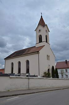
St. Wunibald in Ursheim
|
||
Ursheim is a district of the municipality of Polsingen in the central Franconian district of Weißenburg-Gunzenhausen .
The parish village is located in the southwest of the Weißenburg-Gunzenhausen district about two kilometers north of Polsingen. The Rohrach , a tributary of the Wörnitz , flows through the place. The closest city is Oettingen, eight kilometers away .
Ursheim is mentioned for the first time in a document dated May 1, 899. Until 1971 it was an independent municipality that was incorporated into Polsingen as part of the regional reform . The hamlets Bergershof and Oberappenberg belonged to the community of Ursheim .
Architectural monuments
The neo-Romanesque church of St. Wunibald should be mentioned.
Soil monuments
Infrastructure
State road St 2384 and district road WUG 30 run through Ursheim .
literature
- Johann Kaspar Bundschuh : Ursheim . In: Geographical Statistical-Topographical Lexicon of Franconia . tape 5 : S-U . Verlag der Stettinische Buchhandlung, Ulm 1802, DNB 790364328 , OCLC 833753112 , Sp. 659 ( digitized version ).
- Gottfried Stieber: Ursheim . In: Historical and topographical news from the Principality of Brandenburg-Onolzbach . Johann Jacob Enderes, Schwabach 1761, p. 872-879 ( digitized version ).
Web links
- 1100 years of Ursheim and Appenberg. Contributions to early history with field names
- Ursheim in the Topographia Franconiae
Individual evidence
- ^ Federal Statistical Office (ed.): Historical municipality directory for the Federal Republic of Germany. Name, border and key number changes in municipalities, counties and administrative districts from May 27, 1970 to December 31, 1982 . W. Kohlhammer, Stuttgart / Mainz 1983, ISBN 3-17-003263-1 , p. 715 .
- ↑ Bavarian State Statistical Office (ed.): Official city directory for Bavaria, territorial status on October 1, 1964 with statistical information from the 1961 census . Issue 260 of the articles on Bavaria's statistics. Munich 1964, DNB 453660959 , Section II, Sp. 784-788 ( digitized version ).


