Oettingen in Bavaria
| coat of arms | Germany map | |
|---|---|---|
|
Coordinates: 48 ° 57 ' N , 10 ° 36' E |
|
| Basic data | ||
| State : | Bavaria | |
| Administrative region : | Swabia | |
| County : | Danube Ries | |
| Management Community : | Oettingen in Bavaria | |
| Height : | 419 m above sea level NHN | |
| Area : | 34.23 km 2 | |
| Residents: | 5151 (Dec. 31, 2019) | |
| Population density : | 150 inhabitants per km 2 | |
| Postal code : | 86732 | |
| Area code : | 09082 | |
| License plate : | DON, Lower Austria | |
| Community key : | 09 7 79 197 | |
| LOCODE : | DE OTI | |
| City structure: | 12 parts of the community | |
City administration address : |
Schloßstraße 36 86732 Oettingen i.Bay. |
|
| Website : | ||
| Mayor : | Thomas Heydecker ( SPD ) | |
| Location of the city of Oettingen in the Donau-Ries district | ||
Oettingen in Bavaria (officially Oettingen i.Bay. ) Is a city in the Swabian district of Donau-Ries and the seat of the administrative community Oettingen in Bavaria .
geography
Geographical location
The city lies on the Wörnitz , a tributary of the Danube , and is located on the northern edge of the Ries , a meteorite crater 25 km in diameter.
Community structure
The municipality consists of 6 districts (also former municipalities) and has 12 officially named municipality parts (the type of settlement is indicated in brackets ):
-
 Erlbach ( village ) with Breitenlohe ( hamlet )
 -
 Heuberg ( Kirchdorf ) with Mörsbrunn ( wasteland )
 -
 Lehmingen ( parish village )
 -
 Niederhofen (village) with Lohe (hamlet)
 -
 Nittingen (village) with Bettendorf (hamlet) and Seehof (wasteland)
 -
 Oettingen (main town) with Siegenhofen (hamlet)
history
Until the church is planted
The area was already around 5000 BC. Colonized as Neolithic finds prove. Archaeologists have also discovered the remains of a Bronze Age settlement and a Roman village .
For several centuries the city was the main town of the County of Oettingen . From 1522 to 1731 Oettingen was the double seat of power for the two lines Oettingen-Wallerstein and Oettingen-Oettingen, denominationally divided according to street sides, the municipal institutions were occupied jointly or often alternately. For this reason there were also two synagogues in the city. The Julian and Gregorian calendars worked side by side. After the Thirty Years' War , the area became the new home of numerous Protestants from Austria, who settled there as expellees of faith and took part in overcoming the consequences of the war.
In 1806 Oettingen came to the Kingdom of Bavaria .
20th century
During the Reichspogromnacht in 1938, the synagogue, newly built in Schäfflergasse in 1853, was not burned down due to its proximity to other houses, but the windows, inventory and ritual objects were destroyed, desecrated and stolen. Schoolchildren encouraged to do so by teachers were also involved. Some of the Jewish residents (66 in 1933) were able to emigrate, the last were deported and murdered in 1941/42 (some from other places) . During the Second World War , bomb attacks caused severe damage in Oettingen. On February 23, 1945, the Allies dropped around 500 bombs over the small town from 48 aircraft as part of Operation Clarion . 199 people died.
Incorporations
On January 1, 1972, the previously independent communities Erlbach and Niederhofen were incorporated, on July 1, 1973 Heuberg was added. Lehmingen followed on July 1, 1976. The incorporations were completed on May 1, 1978 with the incorporation of Nittingen.
Population development
Between 1988 and 2018 the city grew from 4,602 to 5,142 by 540 inhabitants or by 11.7%.
politics
City council
The city council consists of the first mayor and 20 city councilors. The city council elections in 2014 and 2020 led to the following results and allocation of seats:
| Party / list | 2014 | 2020 | ||
| Share of votes | Seats | Share of votes | Seats | |
| CSU | FWG | 37.3% | 8th | 32.8% | 7th |
| SPD | 30.2% | 6th | 33.4% | 7th |
| SLO (district list Oettingen) | 15.4% | 3 | 16.1% | 3 |
| PWG (party-free voter group) | 11.7% | 2 | 12.2% | 2 |
| ABL (Active Citizens List) | 5.4% | 1 | 5.5% | 1 |
| total | 100% | 20th | 100% | 20th |
| voter turnout | 68.4% | |||
mayor
The first mayor is Thomas Heydecker (SPD). He has been in office since May 1, 2020. He won the election on March 15, 2020 with 57.7% of the votes against the incumbent Petra Wagner (CSU).
At the top of the city since 1970:
- Hans Raidel from 1970 to 1990 (member of the German Bundestag from 1990)
- Dieter Paus from 1991 to 2008
- Matti Müller from 2008 to 2014 (elected with 55.1% in the 2008 runoff election)
- Petra Wagner from 2014 to 2020 (elected with 52.1% in 2014).
coat of arms
|
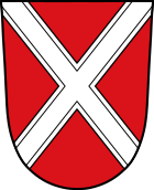
Blazon : "In red a silver tray (St. Andrew's cross) ."
It corresponds to the family arms of the former city lords, the counts and later princes of Oettingen. |
|
Town twinning
-
 Bagolino in the Lombardy province of Brescia , Italy (since 2000)
 -
 Rochechouart in the Haute-Vienne department , Nouvelle-Aquitaine region , France (since 2010)
Culture and sights
- Oettingen Castle
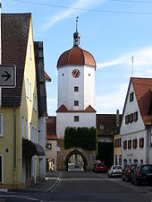
- The so-called King's Tower of the Lower Gate is the only so-called tower of the city fortifications. In front of this gate was the lower suburb, which in turn was closed off by an outer lower gate. The basement still has remains of the tower from the 13th century. Between 1594 and 1596, the two city lords built a new tower together with the citizens. Inside, the cells of the former city prison have been preserved.
- The town hall is one of the most magnificent half-timbered buildings in Swabia. The stone ground floor was built in 1431, as the stone above the portal says. The upper floors and the impressive roof beams were built in 1480. Since the general renovation (1986–1993), the adjacent middle-class half-timbered house from the 17th century has been structurally connected. The town hall is the seat of the city administration and the administrative community of Oettingen, the city traffic office is located on the ground floor.
- The market square is the center of downtown Oettinger. A weekly market takes place there on Fridays. The architectural design is remarkable: on the east side there are baroque gables, on the west side half-timbered gables.
- Oettinger Störche : At least since the time of Count Ludwig XVI. (more than 400 years ago) storks nest in Oettingen. Count Ludwig was a friend of these birds. When, according to a legend, the count had to leave the city after the Schmalkaldic War , the storks also moved away and never came back, an event in which the city took a large part. It was only when the count returned after a long time in 1563 that the storks appeared again and have stayed until today.
- The building of the old grammar school was built in 1724 under Albrecht Ernst II by Johann Christian Lüttich. It housed the Latin school, founded in 1563, which was intended to train the next generation of pastors and officials, as the inscription on the north side says. The west side is adorned by a niche with a shell finish, but in which there was never a statue. Today a senior center and the adult education center are housed in the building.
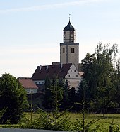
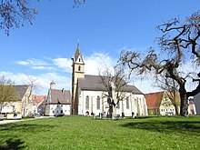
- The Protestant parish church of St. Jakob closes the palace square in the east. The ogival windows on the west facade give the impression of a Gothic church. They were only designed in accordance with the neo-Gothic style in the 19th century . The interior still reveals its Gothic origins in the choir, but was decorated in baroque style under Albrecht Ernst I in 1681. The church was not an original parish ; their mother church is in Ehingen, three kilometers away. When Oettingen became an independent parish in 1312, work began on building the new choir (completed in 1326), and in 1430 with that of the nave. In 1461 the tower stood up to the wreath (year 1461 and coat of arms on the north wall of the tower). The octagon was not completed until 1565. A tower keeper lived there until the 1930s. Up until the middle of the 18th century there was a cemetery around the church, from which the tombstones inside the church come. The Franconian-Swabian Way of St. James leads past it, and the Bavarian-Swabian Way of St. James begins there .
- The Catholic parish church of St. Sebastian has its origins in a blood miracle that is said to have occurred on Sebastian's Day (January 20th) 1467 at this point. Count Ulrich had a chapel built, which was soon expanded into a church. At times there was a considerable pilgrimage there. St. Sebastian is also the patron saint against the plague and is the patron saint of the Ries. According to a vow from 1647, the Wemdinger bring a plague candle to Oettingen in a large procession every 20 years, most recently in 2012. It can be seen next to the plague picture from 1490 to the right of the choir, in the crypt there is a relic of Sebastian . As a result of the denominational division of the city, the church became a Catholic parish church in 1563. In the middle of the 19th century, the nave was torn down due to its dilapidation and rebuilt. The neo-Gothic interior was removed during the renovation in 1959–1963. The figures Anna Selbdritt and the Holy Family come from the St. Anna Chapel.
- Crypt church : The chapel is the remainder of a church that was completed around 1270. On the east facade there is a Romanesque round arch frieze over a large ogival window. Ribs and vault caps show the original red and blue painting. The surfaces are decorated with stars. On the north side of the church there is a faintly visible fresco: Christ as judge of the world in the mandorla with Mary and John from around 1450. In 1798 it was converted into a princely crypt chapel; Of the once five-bay long building, only two bays remain. The classicist interior and a grieving female figure leaning against a marble sarcophagus have not been preserved. To the right and left of the classicist portal there are mourning figures (geniuses of death) by Ignaz Ingerl . The tower, probably from the 15th century, bears the coats of arms of Oettingen, Seckendorf and Sonnenberg on the north side.
- In the area of the crypt garden, Oettingen's germ cell can be assumed. There was probably the manor house from which the Alemannic ingen place developed. As early as around 750, property registers of the Fulda monastery name possessions in "otingen". In the 11th century there was probably a castle there, which was followed by a settlement with craftsmen. The castle and town became the center of the growing county of Oettingen and the headquarters of the Counts of Oettingen. Representative buildings were redesigned or redesigned in the Renaissance and Baroque periods. The so-called Old Castle belonged to the older line of Oettingen-Oettingen, which had been evangelical since 1539, was ruled in 1674 and died out in the male line with Albrecht Ernst II in 1731. In 1850 the castle buildings were demolished except for the chapel.
- The St. Leonhard Chapel is located where an old stone bridge once crossed the Wörnitz. Next to the chapel, built in 1500, the statue of St. Nepomuk originally stood on the old bridge. The chapel holds a gothic carved altar as a treasure. The figures in the shrine represent Saint Leonhard with a chain, flanked by Saint Wolfgang on the left and Saint Roch on the right. The predella shows the fourteen helpers in need . The figures all belong to the period around 1500. The paintings on the side wings with scenes from the life of Mary (inside) and from the life of St. Leonhard are remarkable. The paintings reveal influences from the Dürer school.
- On the opposite side of the river are the St. Anna Chapel with the old cemetery and the former leper house. The chapel was mentioned for the first time in 1484 and was rebuilt in its present form between 1606 and 1608. The art objects from the chapel are an Anna Selbdritt (around 1480/90), a Pietá (late 15th century) and a Holy Family (early 18th century), they are now in the Catholic parish church of St. Sebastian. The Evangelical-Lutheran Diakonia station is now located in the former leper house.
- Calvary Chapel
- synagogue
- Marienbrunnen in the castle courtyard: From the pedestrian passage, there is a good view of the castle courtyard and the fountain with the baroque Marian column from 1723.
- In the middle of the 19th century, the courtyard garden, which was previously designed in the French style, was converted into an English garden according to the fashion of the time. The old trees with some 200-year-old specimens are impressive. Some of the Hofgarten is open to the public today.
- The orangery was built in 1726 by Francesco de Gabrieli for the Oettingen-Spielberg line . It belonged to a French-style park and served as a greenhouse and to accommodate exotic plants that were modern at the time, such as orange and lemon trees or palm trees. Since a renovation in the 1950s, it has been the residence of the princely family Oettingen-Oettingen and Oettingen-Spielberg.
- The city wall from the Hohenstaufen period is almost completely preserved as a wall ring. However, the battlements were demolished at the beginning of the 19th century and only exist in a few places. The city fortifications from the 13th century with its three gates (and the “suburbs” in front of it) have to be imagined like this: A moat led around the city center, which could be crossed on drawbridges at the gates. An earth wall rose behind the moat. Between this earth wall and the actual city wall with a battlement there was a dry ditch as a further obstacle to the approach. The gate towers and several towers in the wall protected vulnerable points.
Architectural monuments
Museums
- Local history museum Oettingen
- Oettingen Castle Museum, opened March 17, 2019
- Fürnheim Brewery Museum
Bathing island with Wörnitz river bath
Through an oxbow lake, the Wörnitz in Oettingen forms an island that offers numerous opportunities for recreational activities. In addition to the Wörnitz river pool and a children's pool, there is a game reserve , two volleyball courts, a soccer field, a mini golf course , a Kneipp facility with a water treading basin and a beer garden .
Geopark Ries information center
Illustrated information boards provide information about the National Geoparks in Germany, the Ries Geopark and the special rocks of the impact crater . The Oettingen information center uses numerous exhibits and display boards as well as a model of the meteorite crater to illustrate the eventful history of the settlement of the northern giant.
Economy and Infrastructure
traffic
Oettingen is on the Nördlingen – Gunzenhausen railway line , on which there is currently no regular passenger traffic.
The federal highway 466 crosses the place. State roads 2214 and 2216 branch off from here.
Established businesses
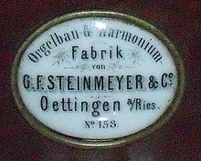
Today, the city has numerous handicraft businesses and wood and metal processing , including Lessmann GmbH, one of the world's largest brush manufacturers, and one of the two German plants of the window and door manufacturer Jeld-Wen . The Oettinger Brewery is one of the largest German breweries in town. There was also the Steinmeyer organ builder there , which u. a. supplied the organ to the city of Akureyri in Iceland . The most famous work by Steinmeyer is the world's largest church organ in Passau Cathedral at the time . The former factory building in historicist style can still be seen.
Personalities
sons and daughters of the town
Sorted by year of birth
- Johannes Kingsattler (1486–1534), Rector of the University of Tübingen
- Hieronymus Wolf (1516–1580), humanist and founder of German Byzantine Studies
- Raimund Minderer (1570–1621), doctor (city physician) of Augsburg, later imperial personal physician
- Maria Dorothea Sophia von Oettingen (1639–1698), Duchess of Württemberg
- Johann Georg Conradi (1645–1699), composer, organist and conductor
- Christine Luise von Oettingen-Oettingen (1671–1747), grandmother of Empress Maria Theresa
- Henriette Dorothea von Oettingen-Oettingen (1672–1728), Princess of Nassau-Idstein
- Georg Christian von Knorr (1691–1762), theologian, Habsburg civil servant
- Johann Aloys I. zu Oettingen-Spielberg (1707–1780), Prince of the Principality of Oettingen-Spielberg
- Johann Friedrich Camerer (1720–1792), lawyer, court officer, folklorist and archaeological pioneer of the 18th century
- Franz Xaver Hammer (1741–1817), gambist, cellist and composer
- Eleanor of Liechtenstein (1745–1812), Princess of Liechtenstein
- Ernst Alois von Meisrimmel (1786–1853), major general of the Württemberg royal family
- Alois III. zu Oettingen-Spielberg (1788–1855), registrar
- Johann Georg Bartholmä (1805–1839), writer
- Otto zu Oettingen-Spielberg (1815–1882), registrar
- Felix Friedrich von Lipowsky (1824–1900), District President in Lower Bavaria
- Carl von Braun (1852–1928), lawyer, President of the Augsburg Higher Regional Court
- Josef Krägel (1853–1932), theater actor and director, bass player and composer
- Johannes Steinmeyer (1857–1928), organ builder
- August Vetter (1862–1923), antiquarian and local history researcher
- Franz Klingler (1875–1933), politician (SPD)
- Christian Herbst (1879–1966), civil servant, district president in Lüneburg
- Karl Friedrich Gustav Hetzel (1889–1966), hydraulic engineer
- Hans Steinmeyer (1889–1970), organ builder and entrepreneur
- Joseph Dantonello (1891–1945), composer, music teacher, singer and conductor
- Theodor Schieder (1908–1984), historian, rector of the University of Cologne
- Rainer Stadelmann (1933–2019), Egyptologist
- Paul Steinmeyer (1933–2019), organ builder
- Eduard Beutel (* 1943), recipient of the Federal Cross of Merit
- Dirk Kollmar (1963–2014), manager and sports official
- Julia Pink (* 1976), porn actress
- Alexandra Shaw (* 1983), national basketball player
- Michael Beutel (* 1988), world champion in sport shooting 2006
Honorary citizen
List (incomplete) by year of award (in brackets):
- Friedrich Philipp August Buhler (1822–1895), (1892)
- August Gramenstetter (1822–1899) surgeon, surgeon and obstetrician, (1897)
- Georg Friedrich Steinmeyer (1819–1901), organ builder and entrepreneur (1899)
- Johannes Steinmeyer (1857–1928), organ builder and entrepreneur (1927)
- Hans Steinmeyer (1889–1970), organ builder and entrepreneur (1964)
- Anton Jaumann (1927–1994), German lawyer and politician of the CSU (1978)
- Caritas (Marie Luise) Hopfenzitz (born November 2, 1913 in the Nittingen district , † January 24, 2005 in Daegu , South Korea ), missionary (1979)
- Franz Bachmayr, first chief physician at the hospital from July 1, 1955 (1995)
- Hans Raidel (* 1941), first mayor from 1970 to 1990 and member of the German Bundestag from 1990 to 2009 (2011)
- Dieter Paus (* 1944), First Mayor (1991–2008) (2018)
Associated with Oettingen
- Johann Georg Mettenleiter (1812–1858), composer and organist, was choirmaster at the parish church
Web links
- City of Oettingen - Official website of the city
- Old views of Oettingen
- Prince of Oettingen-Spielberg administration
- Entry on the coat of arms of Oettingen in Bavaria in the database of the House of Bavarian History
Individual evidence
- ↑ "Data 2" sheet, Statistical Report A1200C 202041 Population of the municipalities, districts and administrative districts 1st quarter 2020 (population based on the 2011 census) ( help ).
- ^ Community Oettingen in the local database of the Bavarian State Library Online . Bayerische Staatsbibliothek, accessed on September 1, 2019.
- ^ Max Spindler , Andreas Kraus : History of Swabia up to the end of the 18th century. (= Handbook of Bavarian History , Volume 3: Franconia, Swabia, Upper Palatinate up to the end of the 18th century. ) Beck, Munich 2001, ISBN 3-406-39452-3 , p. 373.
- ^ Gerhard Beck: Austrian exiles in the Evang.-Luth. Deanery areas Oettingen and Heidenheim. Nuremberg 2002 (sources and research on Franconian family history, 10). ISBN 3-929865-05-X .
- ↑ Rieser Nachrichten: Commemoration of the bomb attack
- ^ Wilhelm Volkert (ed.): Handbook of Bavarian offices, communities and courts 1799–1980 . CH Beck, Munich 1983, ISBN 3-406-09669-7 , p. 541 .
- ^ Federal Statistical Office (ed.): Historical municipality directory for the Federal Republic of Germany. Name, border and key number changes in municipalities, counties and administrative districts from May 27, 1970 to December 31, 1982 . W. Kohlhammer, Stuttgart / Mainz 1983, ISBN 3-17-003263-1 , p. 792 and 793 .
- ^ Bavarian State Office for Statistics
- ^ Website city of Oettingen, election results of the city of Oettingen i.Bay
- ^ Entry on the coat of arms of Oettingen in Bavaria in the database of the House of Bavarian History
- ↑ Homepage of the Castle Museum , accessed on April 2, 2019
- ^ Lessmann GmbH
- ^ List of honorary citizens of the city of Oettingen i.Bay. In: www.oettingen.de. Retrieved July 21, 2020 .
- ↑ Biography of the Order for Caritas Hopfenzitz , accessed on January 27, 2019
- ↑ a b c Rieser Nachrichten of September 18, 2018 , accessed on January 27, 2019
- ↑ Portrait in the Rieser Nachrichten of April 27, 2018 , accessed on January 27, 2019


