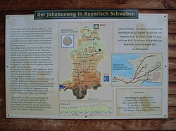
Bavarian-Swabian Way of St. James
| Bavarian-Swabian Way of St. James | |
|---|---|

|
|
| Data | |
| length | 309 km |
| location | Bavarian Swabia |
| Markers | yellow scallop |
| Starting point |
Oettingen 48 ° 57 '15.8 " N , 10 ° 36' 18.4" E |
| Target point |
Lindau 47 ° 32 '49.2 " N , 9 ° 41' 16.8" E |
| Type | Long-distance hiking trail |
| The highest point | Buchenberg 950 m |
| Lowest point | Lindau 410 m |
| Level of difficulty | light |
| season | All year round |
The Bavarian-Swabian Jakobusweg is a long-distance hiking trail and section of the network of the Jakobsweg . It has been leading from Oettingen via Augsburg to Lindau through Bavarian Swabia since 2003 . The signposting of the path is maintained by the Jakobuspilgergemeinschaft-Augsburg, founded in the same year.
course
The 309 km long path leads from the Oettinger Jakobskirche along the eastern edge of the Nördlinger Ries via the pilgrimage site Wemding to Harburg , then via Donauwörth up the Lech to Augsburg. From here it divides into the variants Augsburg- Oberschönenfeld - Babenhausen - Memmingen through the Stauden area , which results in a detour of 35 km, and Augsburg- Türkheim - Bad Wörishofen - Ottobeuren up the Wertach and then through the Unterallgäu. After the two variants have been combined in Bad Grönenbach , the route runs via Buchenberg and Lindenberg to Lindau and to the Jakobskapelle in Nonnenhorn . Since 2005 another signposted route has been leading from Schrobenhausen via Friedberg to Augsburg, which, with the church of St. Jakob and the pilgrims' house, was an important stop for medieval pilgrims.
Since the historically documented pilgrimage route from the medieval metropolis of Augsburg to the south was on the trade routes, which are also important traffic axes today, a new, calmer route of the Way of St. James was laid on hiking trails along the old places of worship such as churches and chapels, both on them and on others Signposts were attached to the way to the milestones. The path is marked with a yellow scallop shell on a white background, with signs at the turns and with stickers along the way. Along the way, pilgrims can get stamps for the pilgrim ID in various churches .
connections
The Bavarian-Swabian Way of St. James forms a section of the way of the pilgrims to Santiago de Compostela . The Jakobsweg Nuremberg-Ulm-Constance also runs through its starting point in Oettingen. The East Bavarian Way of St. James , which comes from the Czech border, joins the Bavarian-Swabian Way in Donauwörth . The Münchner Weg joins this Way of St. James in Buchenberg .
From Weiler-Simmerberg a variant branches off to Bregenz . Both from Bregenz and Lindau, the route continues across Lake Constance , on the south bank of which the route continues through Switzerland from Rorschach as the St. Gallerweg and Appenzellerweg to the Schwabenweg .
literature
- Christiane Haupt, Janina & Markus Meier Bavarian-Swabian Way of St. James - from Oettingen to Lake Constance , Conrad-Stein-Verlag, 2015. 192 pp., ISBN 978-3-86686-488-7
- Ulrich Lohrmann, The Bavarian-Swabian Way of St. James. In daily stages from Ries through Allgäu to Lake Constance. Stöppelverlag, ISBN 978-3-89987-511-9
- Bavarian-Swabian Way of St. James , 1: 50,000. Publicpress, 2008, ISBN 978-3-89920-457-5 , hiking map
- Martin Kluger / Candida Sisto, Jakobus pilgrimage route in Bavarian Swabia. Hiking from Ries to Lake Constance , context verlag augsburg, 2010. 56 pp., ISBN 978-3-939645-32-0
