East Bavarian Way of St. James
| East Bavarian Way of St. James | |
|---|---|
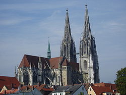
 Regensburg Cathedral |
|
| map | |

|
|
| Data | |
| length | 273 km |
| location | Bavaria |
| Markers |
|
| Starting point |
Všeruby 49 ° 20 ′ 23.6 " N , 12 ° 58 ′ 55.1" E |
| Target point |
Donauwörth 48 ° 43 '7.2 " N , 10 ° 46" 54.4 " E |
| Type | Long-distance hiking trail |
The East Bavarian Way of St. James is a section of the Way of St. James in Bavaria . It was inaugurated in 2004 and leads from the Bavarian Forest via Regensburg and Eichstätt to Donauwörth .
course
The East Bavarian Way of St. James crosses the Free State of Bavaria for 273 km.
From the Czech-German border crossing at Všeruby (Neumark) , which is 2825 km from Santiago de Compostela , the route leads through the Bavarian Forest to the Danube and to Regensburg. From there it continues over the Danube breakthrough at Weltenburg Abbey and the Limesstrasse into the Altmühltal to Eichstätt , before ending in Donauwörth .
connections
The East Bavarian Way of St. James continues the southern Czech variant of the Way of St. James, which leads from Prague to the Czech-German border at Všeruby. In Donauwörth the path joins the Bavarian-Swabian Jakobusweg , which leads via Augsburg to Lake Constance .
Regions
The route runs in the Bavarian administrative districts of Upper Palatinate , Lower Bavaria , Upper Bavaria and Swabia and crosses various landscapes such as the Bavarian Forest Nature Park or the Altmühltal Nature Park .
Stages
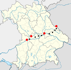
The map shows the route through Bavaria from east to west, the starting point on the Czech-German border, the destination in Donauwörth and the two bishoprics in Regensburg and Eichstätt are marked in red. Some other possible milestones are marked in black.
In detail:
Všeruby (Neumark) • Neukirchen near the Holy Blood • Bad Kötzting • Stallwang • Wörth on the Danube • Regensburg • Kelheim • Altmannstein • Bettbrunn in the Köschinger Forest ( pilgrimage church St. Salvator ) • Stammham • Eichstätt • Rennertshofen • Donauwörth
Signage
![]() The path is continuously signposted with the stylized symbol of the scallop , the rays of which represent the network of paths leading to the destination of the journey - Santiago de Compostela .
The path is continuously signposted with the stylized symbol of the scallop , the rays of which represent the network of paths leading to the destination of the journey - Santiago de Compostela .
Stations
literature
- Hans J. Kolbinger, On the Way of St. James - from Prague via Regensburg and Eichstätt to Donauwörth - The East Bavarian Way of St. James and the southern variant of the Czech Republic , Tyrolia Verlag, 2006, 204 pages, ISBN 978-3-7022-2728-9
Web links
- http://www.vwv.cz/jakub/nemecko1_de.php - stage descriptions, pictures, contacts and links (German and Czech)


