
Concell
| coat of arms | Germany map | |
|---|---|---|

|
Coordinates: 49 ° 4 ' N , 12 ° 43' E |
|
| Basic data | ||
| State : | Bavaria | |
| Administrative region : | Lower Bavaria | |
| County : | Straubing arch | |
| Height : | 588 m above sea level NHN | |
| Area : | 26.75 km 2 | |
| Residents: | 1789 (Dec. 31, 2019) | |
| Population density : | 67 inhabitants per km 2 | |
| Postal code : | 94357 | |
| Area code : | 09963 | |
| License plate : | SR , BOG, MAL | |
| Community key : | 09 2 78 143 | |
| LOCODE : | DE KZE | |
| Community structure: | 59 districts | |
| Address of the municipal administration: |
Rathausplatz 1 94357 Konzell |
|
| Website : | ||
| Mayor : | Johann Kienberger ( CSU / CW) | |
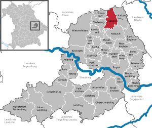
| Location of the municipality of Konzell in the district of Straubing-Bogen | ||
  |
||


Konzell is a municipality in the Lower Bavarian district of Straubing-Bogen .
geography
Konzell is located in the Danube Forest region in the Bavarian Forest . The highest point of the community is at 710 m above sea level. NN , the deepest below 435 m above sea level. NN on the southern boundary of the St 2140 .
Waters
In the district Menhaupten springing Menach . It flows south to the Kinsach and Danube and, together with its tributaries, drains around 10.7 square kilometers in the south of the municipality. About 5.1 km 2 in the west of the municipal area are drained via Kinsach tributaries and the north with about 10.9 km 2 flows into tributaries of the rain .
mountains
The Gallner Berg in the south, the western summit of the Gallner , and the Kramerschopf in the east are the highest peaks at 710 meters each. In the north, the Himmelberg rises at 680 meters.
Community structure
Konzell has 59 districts:
There are the districts Auggenbach, Gossersdorf and Konzell.
history
Until the church is planted
Konzell belonged to the Straubing Rent Office and the Mitterfels Regional Court of the Electorate of Bavaria . In the course of the administrative reforms in Bavaria , today's municipality was created with the municipal edict of 1818 .
20th century
In 1995, the district of Denkzell won the national winner of the competition “ Our village should be more beautiful ” as “Germany's most beautiful village”.
Incorporations
Auggenbach was incorporated as early as 1927. On January 1, 1977, parts of the area of the dissolved municipality of Landorf were incorporated. Gossersdorf was added on May 1, 1978.
Population development
In the period from 1988 to 2018, the municipality grew from 1,720 to 1,768 by 48 inhabitants or 2.8%. On December 31, 2007, Konzell had 1,845 inhabitants.
| year | 1961 | 1970 | 1987 | 1991 | 1995 | 2000 | 2005 | 2010 | 2015 |
| population | 1781 | 1707 | 1751 | 1777 | 1749 | 1759 | 1816 | 1779 | 1820 |
politics
From May 2014 to April 2020 Fritz Fuchs (SPD / Independent Citizens) was the mayor. His predecessor was Michael Kienberger (CSU), who held the office for two terms. On May 1, 2020, Johann Kienberger (CSU / CW) took over the office of first mayor.
Culture and sights
The parish church of St. Martin was built in 1740 on the basis of a previous Gothic building. In 1832 the choir was raised and a new sacristy was built on the north side. This was removed again during a renovation between 1975 and 1977 and replaced by a new sacristy on the south-west side. The church contains a font from the 13th century. The small high altar was built in the Rococo style in the middle of the 18th century, the side altars are works of the late Renaissance around 1650.
Soil monuments
See: List of ground monuments in Konzell
Economy and Infrastructure
Economy including agriculture and forestry
According to official statistics, there were five employees at the place of work in 1998 in the field of agriculture and forestry, 507 in the manufacturing sector and 51 in the field of trade and transport. In other economic sectors 49 people were employed at the place of work subject to social security contributions. There were a total of 559 employees at the place of residence subject to social security contributions. There were none in the manufacturing sector and five in the construction sector. In addition, in 1999 there were 87 farms with an agriculturally used area of 1388 hectares, 410 hectares of which were arable land and 972 hectares of permanent green area.
Today's Klett-Bräu was founded in the 17th century .
education
There are the following facilities:
- Kindergartens: 50 kindergarten places with 33 children (as of 1999)
- Primary school: one with four full-time teachers and 60 students (as of 2018/2019)
- Community College
Personalities
- Johann Kaspar Thürriegel (1722–1800), Prussian-French spy and colonist recruiter in Spanish service
- Karl-Heinz Schmalz , former 2nd Mayor, holder of the Federal Cross of Merit on ribbon, holder of the community medal of the municipality of Konzell
Individual evidence
- ↑ "Data 2" sheet, Statistical Report A1200C 202041 Population of the municipalities, districts and administrative districts 1st quarter 2020 (population based on the 2011 census) ( help ).
- ↑ a b Local elections in the district of Straubing-Bogen. District Sraubing-Bogen, accessed on May 30, 2020 .
- ↑ Map services of the Bavarian State Office for the Environment
- ^ Municipality of Konzell in the local database of the Bavarian State Library Online . Bavarian State Library, accessed on August 6, 2017.
- ↑ District. Municipalities and districts. Bavarian Surveying Administration, archived from the original on April 11, 2013 ; accessed on March 31, 2015 .
- ^ Wilhelm Volkert (ed.): Handbook of Bavarian offices, communities and courts 1799–1980 . CH Beck, Munich 1983, ISBN 3-406-09669-7 , p. 437 .
- ^ Federal Statistical Office (ed.): Historical municipality directory for the Federal Republic of Germany. Name, border and key number changes in municipalities, counties and administrative districts from May 27, 1970 to December 31, 1982 . W. Kohlhammer GmbH, Stuttgart / Mainz 1983, ISBN 3-17-003263-1 , p. 631 and 632 .
- ↑ Konzell primary school in the school database of the Bavarian State Ministry for Education and Culture , accessed on August 27, 2019.
Web links
- Aerial photos of the community
- Entry on the coat of arms of Konzell in the database of the House of Bavarian History

Aholfing | Aiterhofen | Ascha | Atting | Bow | Falkenfels | Feldkirchen | Geiselhöring | Haibach | Haselbach | Hunderdorf | Irlbach | Kirchroth | Konzell | Laberweinting | Leiblfing | Loitzendorf | Mallersdorf-Pfaffenberg | Mariaposching | Mitterfels | Neukirchen | Niederwinkling | Oberschneiding | Parkstetten | Perasdorf | Perkam | Rain | Rattenberg | Rattiszell | Salching | Sankt Englmar | Schwarzach | Stallwang | Steinach | Straßkirchen | Wiesenfelden | Windberg