
Lower Bavaria
| Lower Bavaria | |||
|---|---|---|---|
|
|||
| State : | Germany | ||
| State : | Bavaria | ||
| Administrative headquarters : | Landshut | ||
| Biggest cities: |
1. Landshut 2. Passau 3. Straubing 4. Deggendorf |
||
| Area : | 10,325.93 km² | ||
| Residents : | 1,244,169 (December 31, 2019) | ||
| Population density : | 120 inhabitants per km² | ||
| District President: | Olaf Heinrich ( CSU ) | ||
| District President: | Rainer Haselbeck | ||
| Website : | |||
  Location in Bavaria and Germany |
|||


Lower Bavaria is both a district (third municipal level) and an administrative district of the same area in the Free State of Bavaria .
The districts are self-governing bodies in Bavaria, to which several districts have merged. The districts of a district each belong to an administrative district of the same name , the area of responsibility of the district government (often just government ) as a central state authority . In contrast to the district offices , which are state and municipal authorities at the same time (“ Janus-faced ”), there are separate authorities in Bavaria with the district administrations and the governments .
Lower Bavaria is located in the east of the country and borders the Upper Palatinate in the north, the Czech Republic ( South Bohemia , Pilsen region ) in the northeast, Upper Austria ( Innviertel , Mühlviertel ) in the southeast and Upper Bavaria in the southwest . The term "Lower Bavaria" appears for the first time in 1255 when the Bavarian state was divided. Lower Bavaria was originally much larger: At that time, the Chiemgau and the Bad Reichenhall area were also part of it.
The administrative seat of the district and at the same time the seat of government of the administrative district is Landshut .
The name Niederbayern results from the relative position on the Danube (downstream from Upper Bavaria, just like Upper and Lower Austria).
structure
The administrative region of Lower Bavaria comprises three independent cities and nine districts :
One district cities

Landshut city center with Martinskirche, Germany's highest brick church

The Inn and Ilz flow into the Danube in Passau

Straubing old town

.jpg)
Counties
- Deggendorf district
- Dingolfing-Landau district
- Freyung-Grafenau district
- District of Kelheim
- Landshut district
- District of Passau
- Regen district
- Rottal-Inn district
- District of Straubing-Bogen
Former county names:
- In the transition period from July 1, 1972 to April 30, 1973, the district of Dingolfing-Landau was called the district of Untere Isar.
- In the transition period from July 1, 1972 to April 30, 1973, the district of Freyung-Grafenau was called the district of Freyung.
- In the transition period from July 1, 1972 to April 30, 1973, the district of Rottal-Inn was called the district of Rottal.
Before the district reform

Before the district reform on July 1, 1972, the district of Lower Bavaria had four independent cities and 22 districts. The district of Kötzting, as well as parts of the district of Mallersdorf, moved to the administrative district of Upper Palatinate.
One district cities
- Deggendorf (today a major district town in the Deggendorf district )
- Landshut
- Passau
- Straubing
Counties
Remarks:
- Until 1954, the administrative districts of Lower Bavaria and Upper Palatinate were administered jointly. Parts of it have been preserved to this day and are still jointly administered in Landshut.
- During the Nazi era between 1939 and 1945, the following Sudeten German areas in South Bohemia belonged to the joint administrative district of Lower Bavaria-Upper Palatinate , whereby these districts were assigned to the Lower Bavarian part of the dual government district:
- The administrative seat of Schloss Wolfstein was in Ort until March 30, 1954 , which was incorporated into the city of Freyung on April 1, 1954.
population


| year | Residents |
|---|---|
| 2016 | 1,219,793 |
| 2015 | 1,212,119 |
| 2014 | 1,197,558 |
| 2013 | 1,189,153 |
| 2011 | 1,192,543 |
| 2010 | 1,189,384 |
| 2009 | 1,189,194 |
| 2008 | 1,191,910 |
| 2007 | 1,194,138 |
| 2006 | 1,193,820 |
| 2005 | 1,196,923 |
| 2004 | 1,196,178 |
| 2003 | 1,194,472 |
| 2002 | 1,191,476 |
| 2001 | 1,185,467 |
| 2000 | 1,176,206 |
As of December 31st
Largest cities in Lower Bavaria
According to the Bavarian State Office for Statistics and Data Processing , the largest cities in Lower Bavaria as of December 31, 2019:
| rank | city | district | Residents | image |
|---|---|---|---|---|
| 1. | Landshut | independent city | 73.411 |

|
| 2. | Passau | independent city | 52,803 |

|
| 3. | Straubing | independent city | 47,791 |

|
| 4th | Deggendorf | Deggendorf district | 33,721 |

|
| 5. | Dingolfing | Dingolfing-Landau district | 19,985 |

|
| 6th | Kelheim | District of Kelheim | 16,842 |

|
| 7th | Vilshofen on the Danube | District of Passau | 16,758 |

|
| 8th. | Pocking | District of Passau | 16,041 | |
| 9. | Mainburg | District of Kelheim | 15.163 |

|
| 10. | Neustadt adDonau | District of Kelheim | 14,604 |

|
history

Bavaria after partition in 1392

Overview map by Philipp Apian from 1568: Nidern Bayrn in the map title or Nider Bairen on the map (area colored in green)

Bavaria Inferior on map from 1688
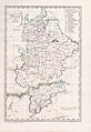
Bavaria's districts 1808 (in Niederbayern Unterdonaukreis , Isarkreis , Regenkreis and Salzachkreis )

District and municipality division 1941 - including the three Sudeten German districts that were affiliated in 1939


Since the Wittelsbachers, like many ruling houses of that time, did not prefer the first-born in succession, in 1255 there was a division into Upper Bavaria with the Palatinate and Nordgau (based in Munich) and Lower Bavaria (with the seats in Landshut and Burghausen ) . The distinction between Upper and Lower Bavaria (see government districts) goes back to this today . In the 14th and 15th centuries, Lower Bavaria (like Upper Bavaria) was repeatedly divided. After the division in 1392 , four duchies existed: Lower Bavaria-Straubing , Lower Bavaria-Landshut , Upper Bavaria-Ingolstadt and Upper Bavaria-Munich , whose dukes often waged war against each other. Duke Albrecht IV of Upper Bavaria-Munich reunited old Bavaria in 1506 after the devastating War of Landshut Succession in 1504/05. He ended the divisions by a primogeniture law . The Bavarian constitution of 1808 divided the Kingdom of Bavaria , which was formed in 1806, uniformly into circles. The districts corresponded to the administrative units of the middle level, i.e. today's administrative districts, and were deliberately outlined according to rational and functional aspects without reference to older administrative or lordly references. Following the French model, the districts were named according to their main rivers. The area of today's Lower Bavaria was divided into the Unterdonaukreis , the Isarkreis , the Regenkreis and the Salzachkreis .
After the Bavarian external borders had repeatedly changed in the following years, the districts were also re-cut so that in 1816 the Lower Danube District comprised large parts of what is now Lower Bavaria's administrative district.
It stayed that way until 1837, when the romantically moved King Ludwig I wanted to replace the French naming system with historicizing names that were supposed to reflect the history of the Bavarian regions. The idea was therefore to rename the area of the Lower Danube District "Lower Bavaria". This alluded to the first division of Bavaria in 1255, which was for Duke Heinrich XIII. had created an independent Lower Bavarian duchy . After temporary reunification in 1340, the duchy was divided into three parts in 1392 : Bavaria-Munich and Bavaria-Ingolstadt emerged in Upper Bavaria, and Bavaria-Landshut in Lower Bavaria . In addition, Bavaria-Straubing had existed in Lower Bavaria as the fourth duchy since 1349 . The district known as "Niederbayern" only partially coincided geographically with the historical Niederbayern. It was more of a traditional name.
April 1, 1932, the administrative districts were Lower Bavaria and Upper Palatinate and Regensburg as part of a program to state simplifying the administrative district of Lower Bavaria and Upper Palatinate merged with the headquarters in Regensburg. In 1939 the administrative district of Niederbayern-Oberpfalz was expanded to include areas that belonged to Czechoslovakia until the Munich Agreement in 1938 , the districts of Bergreichenstein , Markt Eisenstein and Prachatitz , which were separated again in 1945. With the entry into force of the Bavarian Constitution of 1946 (BV) , the administrative districts (districts) were restored in accordance with Art. 185 BV in the form from before 1932/33.
coat of arms
The coat of arms of the district of Niederbayern shows the Bavarian white and blue diamonds in the split shield heraldic on the right and an upright red panther on the left in silver. The white and blue diamonds are detectable as the coat of arms of the Counts of Bogen since 1204 and became after the dynasty of the counts died out Taken over by the Wittelsbach family in 1242. The red panther goes back to the Counts of Orthenburg-Kraiburg , a branch of the Spanheimers , and can also be found in the coats of arms of some Lower Bavarian cities, for example. B. Eggenfelden , Pfarrkirchen or Vilshofen , and also stands (albeit in blue) in the large Bavarian state coat of arms for old Bavaria . The district coat of arms was introduced in this form in 1957.
Coat of arms history
The design of the coat of arms was originally based on a design by the heraldist Otto Hupp , whose design also showed a blue panther and a crown. Around 1900, the then Bavarian Herald's Office received an increasing number of inquiries about the coats of arms of the eight districts at that time (the forerunners of today's districts) that a corresponding request was made to Otto Hupp. In October 1902 a request from the Bavarian Ministry of the Interior was sent to the government of Lower Bavaria with the request to examine the need for representative coats of arms of the communities. The corresponding draft by Otto Hupp was attached to the letter. The district committee showed interest and unanimously agreed to the design and introduction of the district coat of arms. Otto Hupp then published his drafts of the district coats of arms in the "Munich Calendar" in 1906, which have since been viewed and used as the coats of arms of the districts, even if they were not officially recognized. In 1928, the then Bavarian Minister of the Interior denied the need to create official emblems for the districts. In 1956, the Landshut painter Franz Högner received the order from the district council to revise Hupp's design. An expert opinion from the Bavarian Main State Archives now responsible only required a change in the color of the panther, which according to current knowledge was originally red instead of blue. The current coat of arms has been officially in use since 1957.
economy
Due to the fertile loess soils in the Gäuboden, Lower Bavaria is partly characterized by agriculture. Among other things, this administrative region is home to the largest growing area for pickles in Europe , and Lower Bavaria also has a share in the largest hop growing area in the world, the Hallertau . BMW is very important for the economy as an employer with its largest automobile plant in Dingolfing . Unemployment in the administrative district is unevenly distributed across the regions. The unemployment rate in the north-eastern districts such as Freyung-Grafenau is regularly around 13% in February (around 7% in 2008), in the western districts, which are characterized by mechanical engineering and automotive engineering and also benefit from the proximity to the Munich region, only around 3%. In terms of GDP , Lower Bavaria is one of the wealthier regions of the EU with an index of 115 (EU27: 100, Germany: 116) (2008). In addition, the unemployment figures in Lower Bavaria are the lowest in the Free State, according to the figures published by the Federal Employment Agency in 2013, showing an average annual average of 3.6%.
traffic
Street
The district is crossed by the A 3 from Regensburg to Passau, the A 92 from Deggendorf to Landshut and the A 93 from the Hallertau to Regensburg. A fourth motorway, the A 94 from Mühldorf to Pocking, has been under construction for decades.
In addition, several federal highways form a regional road network. These are the B 8 , B 11 , B 12 , B 15 , B 16 , B 20 , B 85 , B 299 , B 301 , B 388 and the B 533 . The Federal Highway 15n is currently under construction.
train
Starting from Regensburg in Upper Palatinate , the two railway lines to Passau and via Landshut and Munich are the most important railway lines in the district. Due to their high gross annual load, they are of considerable supraregional importance, but a comparatively low degree of modernization (e.g. only partially to electronic interlockings connected). The Landshut – Plattling railway connects these two. The Regensburg – Ingolstadt railway crosses Lower Bavaria in the Kelheim district.
In addition, there is regular passenger transport on the Landshut – Mühldorf , Passau – Mühldorf , Mühldorf – Simbach , Plattling – Bayerisch Eisenstein , Zwiesel – Grafenau , Zwiesel – Bodenmais , Gotteszell – Viechtach , Neufahrn – Straubing and Straubing – Bogen routes .
Private operators offer regular special trips on the Passau – Freyung , Eggmühl – Langquaid and Landshut – Unterneuhausen railway lines .
The Deggendorf – Hengersberg and Vilshofen – Neustift-Blindham railway lines are still regularly used for freight traffic.
In addition, other railway lines were shut down.
shipping
With the Danube and the Main-Danube Canal branching off at Kelheim , an important European shipping route crosses Lower Bavaria. To improve navigability , the section of the Danube between Straubing and Vilshofen is to be regulated in terms of river engineering . For nature conservation reasons, this is highly controversial.
air traffic
There are a total of twelve airfields in Lower Bavaria:
- Arnbruck airfield
- Deggendorf airfield
- Dingolfing airfield
- Eggenfelden airfield
- Fürstenzell airfield
- Elsenthal-Grafenau airport
- Kirchdorf / Inn airfield
- Landshut Airfield
- Pfarrkirchen airfield
- Sun airfield
- Straubing Airfield
- Vilshofen airfield
The largest airports are Straubing with 1350 m, Eggenfelden with 1160 m, Vilshofen with 1138 m and Landshut with 900 m runway length.
Protected areas
In the administrative district there are 66 nature reserves , 64 landscape protection areas , 82 FFH areas , twelve EU bird protection areas and at least 305 geotopes (as of March 2017). The largest nature reserve in the district is the mouth of the Isar and the largest nature reserve is the Bavarian Forest .
See also:
- List of nature reserves in Lower Bavaria
- List of landscape protection areas in Lower Bavaria
- List of FFH areas in Lower Bavaria
- List of EU bird protection areas in Lower Bavaria
- List of geotopes in Lower Bavaria
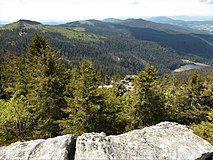
View from the Großer Arber

Danube breakthrough near Weltenburg

Growing rock from Usterling

Isar mouth near Deggendorf


education
There are three universities in total in Lower Bavaria:
- Deggendorf University (founded in 1994)
- Landshut University (founded 1978)
- University of Passau (founded 1978, previously philosophical-theological university since 1823)
The Straubing campus of the Technical University of Munich is also located here .
After the University of Ingolstadt was relocated to Landshut in 1800 , there was already a university in Lower Bavaria by 1826 . This was then relocated to Munich and continues today under the name Ludwig Maximilians University .
district
The district of Niederbayern , together with the other Bavarian districts, forms the third municipal level in the state. The core tasks of the district are in the social and cultural area. The organs of the district are the district assembly , the district committee and the district assembly president ( Art. 21 District Code - BezO ).
history
The Kingdom of Bavaria was still to Prussia divided into circles its territory 1806th From 1828 to 1919 there was a district councilor (h) as a representative body for Lower Bavaria (Lower Danube district until 1837), from 1919 to 1945 the corresponding term was district council (from 1932 amalgamation with the Upper Palatinate as the district council of Lower Bavaria and the Upper Palatinate ). During the Nazi era, however, the designation "district" was adjusted to the Prussian designation "district" and in 1939 the "district offices" were renamed uniformly throughout the empire to "districts", which the constitution of the Free State of Bavaria ignored shortly after the Second World War. The local parliaments, called district days despite the provisions in the constitution, were re-elected in 1954 for the first time after the Second World War .
- President of the District Administrator (h) s
- Julius von Niethammer (1839–1843, 1845–1847)
- Baron von Berchem (1844)
- Christian Freiherr von Grießenbeck (1848–1850)
- Philipp Graf von Hundt (1852–1855)
- Johann Kast (1855–58)
- Joseph Ludwig Leeb (1859–1869)
- Ludwig von Lottner (1869–1874)
- Anton Pummerer (1874–1875)
- Franz Xaver Harlander (1876–1879)
- President of the District Council
- Carl Sittler (1919–1933)
- August Donderer (1933 / 4–1945), from 1939 President of the District Association of Lower Bavaria and the Upper Palatinate
- District assembly president since 1954
- Wilhelm Schönhuber (1954–1958)
- Franz Graf von Spreti (1958–1962)
- Josef Haufellner (1962–1970)
- Karl Freiherr von Moreau (1970–1978)
- Sebastian Schenk (1978–1998)
- Manfred Hölzlein (1998-2013)
- Olaf Heinrich (2013–)
District day
composition
| choice | CSU | SPD | FW | Green | left | ödp | FDP | REP | BP | AfD | NPD | GDP¹ | total |
|---|---|---|---|---|---|---|---|---|---|---|---|---|---|
| 2018 | 9 | 2 | 4th | 2 | 1 | 1 | 1 | 1 | 3 | 24 | |||
| 2013 | 9 | 3 | 2 | 1 | 1 | 1 | 1 | 18th | |||||
| 2008 | 9 | 3 | 3 | 1 | 1 | 1 | 18th | ||||||
| 2003 | 12² | 3 | 1 | 1 | 1² | 18th | |||||||
| 1998 | 12 | 6th | 1 | 1 | 20th | ||||||||
| 1994 | 12 | 6th | 1 | 1 | 20th | ||||||||
| 1990 | 13 | 5 | 1 | 1 | 20th | ||||||||
| 1986 | 14th | 5 | 1 | 20th | |||||||||
| 1982 | 15th | 5 | 20th | ||||||||||
| 1978 | 15th | 5 | 20th | ||||||||||
| 1974 | 15th | 5 | 20th | ||||||||||
| 1970 | 16 | 5 | 21st | ||||||||||
| 1966 | 13 | 6th | 1 | 1 | 21st | ||||||||
| 1962 | 14th | 7th | 2 | 2 | 25th | ||||||||
| 1958 | 13 | 5 | 4th | 3 | 25th | ||||||||
| 1954 | 11 | 5 | 6th | 3 | 25th |
¹ 1954 and 1958 GB / BHE
² On February 27, 2006, the ödp lost its district assembly seat when its district assembly member left the party. This district council switched to the CSU.
District President
The District Assembly President has been Olaf Heinrich ( CSU ) since 2013 . Vice-President has been Dr. Thomas Proeckl (CSU). Rita Röhrl ( SPD ) is also another deputy of the district assembly president.
Administrative district
The administrative district of Niederbayern is geographically identical to the district of Niederbayern. He is the area of responsibility of the state middle authority government of Lower Bavaria .
literature
- Gerald Huber : A short history of Lower Bavaria. 2nd Edition. Verlag Friedrich Pustet, Regensburg 2010, ISBN 978-3-7917-2048-7 .
- Gerald Huber / Harry Zdera /: Landshut , Verlag Friedrich Pustet, Regensburg 2009, ISBN 978-3-7917-2190-3 .
- Annemarie Liebler : In the homeland of Raute and Panther. History of the government of Lower Bavaria Herbert Utz Verlag, Munich 2008, ISBN 978-3-8316-0836-2 .
- Franz X. Bogner: Lower Bavaria from the air . Verlag Friedrich Pustet, Regensburg 2010, ISBN 978-3-7917-2276-4 .
Web links
- Official website of the district of Lower Bavaria
- Government of Lower Bavaria
- Lower Bavaria portal
- Lower Bavaria: Official statistics of the LfStat
Individual evidence
- ↑ "Data 2" sheet, Statistical Report A1200C 202041 Population of the municipalities, districts and administrative districts 1st quarter 2020 (population based on the 2011 census) ( help ).
- ↑ Bavarian State Office for Statistics: Population: administrative district, gender, marital status, age (88), reference date
- ^ Bavarian State Office for Statistics and Data Processing: Genesis - Online database: Population: municipalities, reference dates (last 6) . Online at www.statistikdaten.bayern.de, accessed on August 26, 2016.
- ↑ History of the coat of arms: on Bezirk-Niederbayern.de
- ↑ Bavarian State Office for Statistics: Population: administrative district, gender, marital status, age (88), reference date ( memento from January 7, 2014 in the Internet Archive )
- ^ Royal Bavarian District Official Gazette of Lower Bavaria
- ^ Result of the district election of Lower Bavaria 2018
- ↑ 2013 result
- ↑ Current composition of the District Assembly of Lower Bavaria
Coordinates: 48 ° 41 ′ N , 12 ° 45 ′ E