
Mühlviertel
Coordinates: 48 ° 25 ' N , 14 ° 20' E

| Quarter and districts of Upper Austria |
|---|
 |
The Mühlviertel (in place names also Mühlkreis ) is a landscape in Austria and represents one of the four historical "quarters" of Upper Austria . It is that part of Upper Austria that lies north of the Danube and belongs to the granite and gneiss highlands .
The Mühlviertel takes its name from the rivers Große Mühl , Kleine Mühl and Steinerne Mühl , which flow through it. The Mühlviertel in its current terminology has existed since 1779, when the Machlandviertel opened up in the Mühlviertel.
Since the formation of the political districts in 1868, the quarters in Upper Austria no longer have a legal basis and are purely landscape names. The older district division , which was still based on the old quarters, was replaced.
The urban area of Linz north of the Danube (urban districts Urfahr , Pöstlingberg , St. Magdalena and Dornach-Auhof ) also belongs to the Mühlviertel.
If you add up the political districts north of the Danube, the Mühlviertel covers 3080 km², 25.7 percent of the area of Upper Austria (11980 km²) and is therefore the second largest of the four quarters after the Traunviertel .
geography


The Mühlviertel borders Bavaria to the west, southern Bohemia to the north and Lower Austria to the east and southeast . Naturally, it belongs to the granite and gneiss highlands of the Bohemian Massif . The highest mountain is the Plöckenstein at 1,378 meters in the Austrian Bohemian Forest at the border triangle . In the municipality of St. Nikola an der Donau near Hirschenau , the lowest point of the Mühlviertel is 228 meters. The only flat zones of the Mühlviertel are between Aschach and Ottensheim (the part of the Eferdinger Basin north of the Danube ) and between Mauthausen and Grein ( Machland ).
Granite and gneiss are the geological subsoil of the Mühlviertel, the rivers and streams flow - with a few exceptions in the northern Mühlviertel, beyond the European main watershed - to the Danube. The Mühlviertel differs significantly from other parts of the country mainly due to its location and its geological subsoil in terms of flora and fauna. Special features in the nature of the Mühlviertel include largely natural flowing waters, Bürstling meadows ( borst grass lawn ), rock formations ( wool sack weathering ), moors , otters , lynx and Bohemian gentian .
The Haselgraben divides the Mühlviertel into the upper and lower Mühlviertel . The river valleys Mühltal and Feldaistsenke further divide the landscape from west to east into the Passau - the Linz - and the Greiner forest .
NUTS breakdown
In the NUTS classification used for the official statistics of the EU , the Mühlviertel can be found in two of the five groups of districts ( NUTS level : AT -2) in Upper Austria, the code and includes four political districts except the judicial district Urfahr , which is part of the code heard:
AT313AT312
- Free City
- Perg
- Rohrbach
- Urfahr environment (divided into AT312 and AT313)
The city of Linz north of the Danube and part of the Urfahr-Umgebung district, which are included in the landscape of the Mühlviertel, do not belong to the corresponding statistical region. According to this, Upper Austria is not divided into its traditional four quarters in statistics at the European level, but into its regions Innviertel, Mühlviertel, Traunviertel, Hausruckviertel, Linz-Wels and Steyr-Kirchdorf. This also corresponds to the modern spatial planning concept in which the Upper Austrian central area is singled out as the "fifth" quarter.
Room units
The federal state of Upper Austria is divided into 41 spatial units . An overview according to nature conservation criteria such as geology , geomorphology and use of space ( settlement , agriculture, etc.) is provided by the spatial units that (wholly or partially) belong to the Mühlviertel.
- Aist-Naarn-Kuppenland
- Bohemian forest
- Danube gorge and side valleys
- Eferdinger Basin
- Freiwald and Weinsberger Wald
- Leonfeldner highlands
- Linz field
- Machland
- Southern Bohemian Forest foothills
- Southern Mühlviertel outskirts
- Central Mühlviertel highlands
history
Early history
The oldest archaeological finds date from the Stone Age and were made, for example, at Perg and the Berglitzl .
In Unterweitersdorf were barrows and 20 urn discovered which date back to the period between the 13th and 11th century BC.
In Mitterkirchen , excavations between 1981 and 1990 discovered a Hallstatt cemetery with around 80 graves and around 900 vessels and remains of settlements. These finds date from the 7th century BC. An open-air museum was built in Mitterkirchen , which tries to give an impression of everyday life in the early Iron Age.
In Roman times , the Mühlviertel was a dense and barely inhabited jungle. It is believed that Slavs inhabited the Mühlviertel in the early Middle Ages . Slavic place and field names such as Tobra (near Perg ) and Tabor (near Ottensheim ) or Jaunitz (near Freistadt ) mark the early medieval border situation.
Settlement
Since the Baiern settled in this area, it became largely part of their duchy (from the middle of the 6th century), then owned by the Babenbergs with large estates between the Danube and the Bohemian Forest .
In the 11th and 12th centuries, after the Hungarians were finally pushed back, the Mühlviertel hills were settled along so-called clearing strips between the Danube and the Bohemian Forest Ridge, with most of the left tributaries of the Danube also serving as border rivers:
| No | eastern border river | most important rule | Mother parish | first mention |
|---|---|---|---|---|
| 1 | Little mill | Falkensteiner (1289/90 to Duke Albrecht ) | Parish churches in the Mühlkreis | 1230 |
| 2 | Große Mühl (on the upper reaches near Haslach) | Schönhering-Blankenberg (around 1190 to the Waxenberger ) | Altenfelden | 1242 |
| 3 | Small toboggan | Eppo von Windberg (donated to St. Florian Monastery around 1108 ) | Feldkirchen an der Donau and Niederwaldkirchen | 1110 and around 1108 |
| 4th | Haselbach | Wilhering-Waxenberger (from 1170 "Waxenberger" for short) | Gramastetten | 1110 |
| 5 | Big Gusen | Haunsperger | Gallneukirchen | 1125 |
| 6th | Waldaist | Lords of Aist | Ried in der Riedmark (transferred to St. Florian Monastery in 1122 ) | 823 |
| 7th | Naarn | Regensburg Monastery | Naarn in the Machlande | 823 |
| 8th | Ysper | Lords of Perg and Machland | Saxen ( transferred to Waldhausen Abbey in 1147 ) | 823 |
In 1180 the Babenbergers also acquired the western Mühlviertel and founded the first town in 1220, Freistadt . Most of the Mühlviertel was only cleared during the high and late Middle Ages . The place names that end with -schlag , such as Bernhardsschlag, bear witness to the clearing. Real –ing place names (e.g. Hütting, Inzing, Arbing ) testify to the Bavarian colonization.
15th century
For the first time around 1478, the land above the Enns was divided into four “quarters”. Today's Mühlviertel includes two of the former quarters, the western Mühlviertel and the eastern Machlandviertel . Other sources also call the eastern part the Schwarzviertel . The border between the two districts was, depending on the source, the Große Rodl , the Haselgraben or the Große Gusen . In the course of time, the limit is likely to have shifted several times, which leads to this inaccurate information. In 1491 Grein was promoted to town and was the second town in the entire Mühlviertel.
17th and 18th centuries
Around 1600 the good reputation of the Mühlviertel weaving trade arose . Weavers' markets were set up in numerous communities with market rights . In such communities, in many cases half of the residents earned their income from weaving or its secondary occupations. The weavers used flax as raw material , which at that time was widely grown in the Mühlviertel. In addition to wood, salt and iron goods (scythes), weaving products were once one of Upper Austria's most important export items. Like the other craftsmen's guilds, the weavers' market guilds joined together to form a state organization whose privilege , like market rights, had to be confirmed or granted again when a new sovereign prince took office.
The activities of the country weaving guild difficult for a "Gäuweber" who saw due to own real property is no need in a candidate of the National Association, and second, the numerous small buyers of yarn this to the time in strong demand twister processed, and could export with much profit. On the one hand, raw material was withdrawn from the weavers and, on the other hand, it was made more expensive by the higher demand. Around 1700, foreign competition also increased, which led some weavers who had come under pressure to faster, less precise work or other attempts at fraud. This is evidenced by stricter quality and control regulations that were issued at the time.
In the 16th and 17th centuries the Mühlviertel was - like large parts of the Austrian provinces - a largely Protestant cultural area. With the implementation of the Counter Reformation , especially after the end of the Thirty Years' War, thousands of evangelicals were forced to leave their homeland. They found a refuge particularly often in the regions of Franconia , which were badly devastated by the war , where the awareness of common origins has partly been preserved to this day.
When the Innviertel fell to Upper Austria with the Treaty of Teschen in 1779 , the two quarters north of the Danube were merged to continue to have four quarters. With the constitutional reform under Josef II , the Mühlkreis was created as an administrative unit in 1783. The Mühlkreis was first administered by Freistadt, before the district administration was transferred to the then still independent market town of Urfahr in 1794 and to Linz in 1812.
19th century

The great importance of weaving continued until the end of the 19th century, when mechanical looms and industrialization stopped weavers.
The technical progress in transport on the European mainland began in the early 19th century in the Mühlviertel with the construction of the horse-drawn railway from Linz to Budweis . It was the first railroad in continental Europe . The Summerauer Bahn was built between 1871 and 1872, the Mühlkreisbahn in 1885 and the Donauuferbahn in 1888 . Since then the Mühlviertel has three railway lines.
20th century
In the spring of 1945, parts of the population of the Mühlviertel took part in the so-called " Mühlviertel Hare Hunt " for three weeks . 500 prisoners who escaped from the Mauthausen concentration camp were hunted down, true to the motto "not to bring anyone back to the camp alive". Only nine people survived the hunt by the SS , SA , Gendarmerie, Wehrmacht , Volkssturm , Hitler Youth and civilians .
During the occupation , the Mühlviertel was occupied by Soviet troops. The civil administration Mühlviertel maintained the connection to the rest of Upper Austria.
With the establishment of today's Johannes Kepler University Linz in 1966 on the grounds of Auhof Castle, science moved into the Mühlviertel. A branch of this university exists in the small Mühlviertel community of Hagenberg . This location, together with the university of applied sciences, also became a top-class training location for IT . The Anton Bruckner University for Music in Upper Austria is based in Urfahr , so it is also located in the Mühlviertel.
The Mühlkreis Autobahn (A 7) was built in the 1970s and ends today in Unterweitersdorf . The extension to the Czech border was never realized. As a supplement to Freistadt, the Mühlviertler Schnellstraße (S 10) was opened at the end of 2015 , which is to offer a motorway-like connection to the Czech border from 2020.
economy & Administration and Management

The people in the Mühlviertel live on barren ground. Many families of the numerous part-time farmers get their additional income from work in Linz businesses or from tourism, which mediates “soft” tourism here. In earlier centuries, the main occupation was, in addition to agriculture, the cultivation of flax and hops . Linen weaving brought prosperity to the villages, today it is only represented by a few companies. In the cities and markets, trading in salt and other goods was added as a source of income. The tradition of brewing beer is still alive. For several decades now, hops have been grown again in the Mühlviertel.
In comparison with the other 34 regions of Austria in terms of economic power per capita (GDP), the Mühlviertel was in penultimate place in 2007 with around 18,100 euros. This value is around 45% below the Austrian average of 32,600 euros.
traffic
The Mühlkreisbahn and the Mühlkreis Autobahn connect the Mühlviertel with the Upper Austrian capital Linz : starting by rail from Aigen-Schlägl, starting on the road from Unterweitersdorf .
tourism
In the Mühlviertel, also a development area in terms of tourism , a steering group for the Mühlviertel brand was created within the regional tourism organization Upper Austria Tourism with the newly created regional tourism conferences (Upper Austrian Tourism Law Amendment 2012) . It includes representatives of the tourist organizations (tourism associations), the Chamber of Commerce and operational cooperation partners such as Holidays on the Farm and the ARGE Quality Tourism Mühlviertel (Mühlviertel pure) . In addition to the almost 50 local associations, the conference also includes the regional (multi-municipality) tourism associations Mühlviertler Alm , Mühlviertler Kernland , TraumArena and Böhmerwald , and the regional projects Mühlviertel Nature Park and Sterngartl Gusental , which are to develop into further municipal associations. Other quarter-wide projects include the Mühlviertler Wandersleut ' consortium (hiking tourism division). There is also close cooperation via the Mühlviertel regional management team with the cross-border Euregio Bavarian Forest - Bohemian Forest .
Communities
The Mühlviertel consists of 120 independent communities and as of 1991 had 246,419 inhabitants. After Burgenland, with an average of only 2053 inhabitants per municipality, it has the second lowest average number of inhabitants per municipality of all regions in Austria (see also municipalities of the states of Europe or municipal merger ); The whole of Austria had an average of 4086 inhabitants per municipality in 2015.
Arts and Culture
The Mühlviertel was home to a number of artists. For example, it should be pointed out to Karl Kronberger : He was born in Freistadt and later also worked in Munich. The Mühlviertel also attracted numerous artists from abroad, such as Franz von Zülow , who had his summer residence in Hirschbach in the Mühlkreis . He is the namesake of one of the most renowned artists 'associations in Upper Austria, the " Zülow Group ", the former Mühlviertel artists' guild , which consists mainly of representatives of the modern avant-garde and is based in Linz .
Behind glass painting in Sandl has an old tradition . It is still practiced in the traditional form and is represented in the Mühlviertel Castle Museum (Freistadt) with Europe's most extensive collection.
Edward Samhaber , a native of Freistadt, was a 19th century poet. Norbert Hanrieder , who was a pastor in Putzleinsdorf , was one of the most important dialect poets in Upper Austria, and he also wrote the Mühlviertel hymn .
The Austrian writer Henriette Haill , who was born in Linz, went into hiding with her four children during the Second World War to protect them from persecution by the National Socialists in the Mühlviertel. Here she created a large part of her works and published many of them in the Mühlviertler Heimatblatt. Haill was a founding member of the Mühlviertel artists' guild and editor of their magazine.

Adalbert Stifter was not a native of the Mühlviertel - the house he was born in is in Oberplan in neighboring South Bohemia - but he was culturally anchored in the region. For example, he renovated the world-famous Kefermarkt winged altar . In addition to this major work of Gothic carving, there are five other large winged altars from this artistic era in the Mühlviertel .
Hans Schnopfhagen from Oberneukirch set the Hoamatgsang by Franz Stelzhamer , which has been the Upper Austrian national anthem since 1952 .
Anton Bruckner , one of the great European composers of the Romantic period , found his first professional job as an assistant teacher in Windhaag near Freistadt . The first compositional works such as the Windhaag Fair were also created in this small border town .
As a counterbalance to the largely traditional environment, a “zeitgeist” cultural scene emerged in some places, such as the Jazz Days in Ulrichsberg , which are well known throughout Austria .
Grein an der Donau went down in the country's theatrical history with its municipal theater , which was built in 1791 and is Austria's oldest.
Mythological
With its granite boulders and pitch and shell stones, the Mühlviertel has many places of worship . The Heidenstein near Eibenstein and the Berglitzl in Langenstein are two examples of old sacrificial sites. Another special feature is a mummy, the Luftg'selchte pastor in St. Thomas am Blasenstein . Many of these cult sites were surrounded by churches or chapels, and some were converted into Catholic pilgrimage sites.
Worth mentioning
On 20 October 2009 discovered amateur astronomer David Voglsam with observations on the observatory Davidschlag a minor planets of the inner asteroid belt , which later named (243491) Mühlviertel received. The celestial body with a diameter of about 4 kilometers has a solar orbit period of 3.23 years.
photos
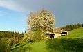
Old barn

Old granite farmhouse

Grain field

The Feldaist, a river in the Mühlviertel
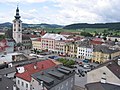
The main square of Freistadt

The spa town of Bad Leonfelden

The Grein Danube Market with Greinburg Castle
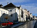
Town houses in Neufelden

The Sternsteinwarte in winter


.jpg)


See also
- Mühlviertel Alm
- The other quarters in Upper Austria: Hausruckviertel , Innviertel and Traunviertel
literature
- Benno Ulm : The lower Mühlviertel until 1500. In: Mühlviertler Heimatblätter . Volume 7/8, Linz 1964, online (PDF) in the forum OoeGeschichte.at.
- Klaus Rumpier: Historical development of the Mühlviertel from 1500 to 1790. In: The Mühlviertel. Upper Austria. National exhibition. Volume 2, Linz 1988, pp. 289-296, PDF on ZOBODAT
- Kristian Sotriffer (Ed.): The Mühlviertel. Dream of a landscape. OLV-Buchverlag, Linz 1981, ISBN 3-85214-307-1 .
- Hermann Kohl: The lifeless nature. Contribution to the state exhibition in 1988 in Weinberg Castle (Kefermarkt).
- Eberhard Krauss: Exiles from the Upper Austrian Mühlviertel in Franconia (= sources and research on Franconian family history. 23). Nuremberg 2010, ISBN 978-3-929865-53-0 .
- Karina Grömer: North-South routes through the Upper Austrian Mühlviertel in prehistoric times. Around 2005 ( PDF on turntobel.com).
- Otto Milfait : The Mühlviertel. Language, custom and saying.
music
- "Ös Leutl von Inn" is the Mühlviertel anthem by Norbert Hanrieder .
Web links
- www.muehlviertel.at Website of the Mühlviertel Marken GesmbH - cooperation between the tourism associations of the Mühlviertel region
- Entry on Mühlviertel in the Austria Forum (in the AEIOU Austria Lexicon )
- Harald Gruber: Norbert Hanrieder came back to his room In: Mühlviertel Volksblatt , pp. 26–27, June 3, 2004.
Individual evidence
- ↑ DORIS: Upper Austria's Quarter (PDF), accessed on November 12, 2015.
- ↑ For background information on Eurostat's NUTS classification, see Background. NUTS - Nomenclature of territorial units for statistics. Eurostat , accessed February 8, 2020 . NUTS classification in direct download (Excel file, 527 kB)
- ↑ The Neanderthal in the Austrian Ennstal ( Memento from July 21, 2013 in the Internet Archive ). Archeology online. Retrieved June 16, 2011.
- ^ Barrows on the expressway ( Memento from March 27, 2011 in the Internet Archive ). Website of the Federal Monuments Office. Retrieved September 21, 2010.
- ↑ Manfred Pertlwieser : Early Hallstatt period graves near Mitterkirchen (Upper Austria). In: Antike Welt, 18/1, 1987, pp. 48-56; Manfred Pertlwieser: The Hallstatt- era barrows of Mitterkirchen. Excavation results from 1981–1990. Publications of the Association of Austrian History Societies. 1991
- ↑ Chapter settlement and clearing. In: Benno Ulm : The Mühlviertel. Verlag St.Peter, Salzburg 1976, ISBN 3-900173-05-2 , pp. 19-25.
- ↑ Literature on the settlement of the Mühlviertel in the forum OoeGeschichte.at
- ↑ a b c see certificate Confirmatio Ludovici Pii
- ↑ Map from the 17th century in Upper Austria - portrait and identity of a country. Rudolf-Trauner-Verlag, Linz 2000, p. 11.
- ↑ Rudolf Lehr (Ed.): Landeschronik Oberösterreich. 3000 years in data, documents and images. Vienna / Munich 1987, p. 8.
- ↑ Rumpler 1988, p. 292.
- ↑ Der Standard: Metropolitan areas and west with the highest GDP per capita in 1991
- ↑ Tourist branding process Mühlviertel . oberoesterreich-tourismus.at / About us / Tourist brand process Mühlviertel, May 10, 2013
- ↑ The 5 regions in the Mühlviertel , muehlviertel.at (TraumArena not explicitly mentioned there)
- ↑ See development of cross-border cycling tourism in Mühlviertel / Lipno , Regional Management Upper Austria, rmooe.at
- ↑ Wikipedia: Municipalities of the States of Europe , accessed on December 27, 2015.
- ^ Places of power in Austria , accessed on January 14, 2012.
Innviertel |
Mühlviertel |
Hausruckviertel |
Traunviertel
Upper Austrian central area ("5th quarter")
NUTS: AT-1 group of federal states : AT1 Eastern Austria • AT2 Southern Austria • AT3 Western Austria
NUTS: AT-2 federal states : AT11 Burgenland • AT12 Lower Austria • AT13 Vienna • AT21 Carinthia • AT22 Styria • AT31 Upper Austria • AT32 Province of Salzburg • AT33 Tyrol • AT34 Vorarlberg
NUTS: AT-3 group of districts : AT111 Mittelburgenland • AT112 Northern Burgenland • AT113 Southern Burgenland • AT121 Mostviertel-Eisenwurzen • AT122 Lower Austria-South • AT123 St. Pölten • AT124 Waldviertel • AT125 Weinviertel • AT126 Vienna region / northern part • AT127 Vienna region / southern part • AT130 Vienna • AT211 Klagenfurt-Villach • AT212 Upper Carinthia • AT213 Lower Carinthia • AT221 Graz • AT222 Liezen • AT223 Eastern Upper Styria • AT224 Eastern Styria • AT225 Western and Southern Styria • AT226 Western Upper Styria • AT311 Innviertel • AT312 AT314 Mühlviertel • AT312 Linz-Wels Steyr-Kirchdorf • AT315 Traunviertel • AT321 Lungau • AT322 Pinzgau-Pongau • AT323 Salzburg and surroundings • AT331 Ausserfern • AT332 Innsbruck • AT333 East Tyrol • AT334 Tiroler Oberland • AT335 Tiroler Unterland • AT341 Bludenz-Bregenz Forest • AT342 Rheintal-Bodensee region
LAU: AT-1 not occupied