
Niederwaldkirchen
|
market community Niederwaldkirchen
|
||
|---|---|---|
| coat of arms | Austria map | |
 |
|
|
| Basic data | ||
| Country: | Austria | |
| State : | Upper Austria | |
| Political District : | Rohrbach | |
| License plate : | RO | |
| Surface: | 28.26 km² | |
| Coordinates : | 48 ° 27 ' N , 14 ° 5' E | |
| Height : | 525 m above sea level A. | |
| Residents : | 1,835 (January 1, 2020) | |
| Population density : | 65 inhabitants per km² | |
| Postal code : | 4174 | |
| Area code : | 07231 | |
| Community code : | 4 13 23 | |
| NUTS region | AT313 | |
| Address of the municipal administration: |
Markt 22 4174 Niederwaldkirchen |
|
| Website: | ||
| politics | ||
| Mayor : | Erich Sachsenhofer ( ÖVP ) | |
|
Municipal Council : (2015) (19 members) |
||
| Location of Niederwaldkirchen in the Rohrbach district | ||
  |
||
| Source: Municipal data from Statistics Austria | ||

Niederwaldkirchen is a market town in Upper Austria in the Rohrbach district in the upper Mühlviertel with 1835 inhabitants (as of January 1, 2020). The community is located in the judicial district of Rohrbach .
geography
Niederwaldkirchen lies at an altitude of 525 m above sea level. A. in the southeastern part of the Rohrbach district in the upper Mühlviertel . In terms of the nature conservation spatial structure, almost the entire municipality belongs to the Central Mühlviertel highlands , only the extreme northeast of Niederwaldkirchen is part of the southern Bohemian Forest foothills . It extends from north to south 6.9 km, from west to east 8 km, the total area is 28.26 km². Niederwaldkirchen is the seventh largest municipality in the Rohrbach district in terms of area. With 62 inhabitants per km², the municipality was in the middle of the range of municipalities in the district in 2013. The municipality extends over an average altitude of 500 to 600 meters and in 2001 was 21 percent forested, 73 percent of the area was used for agriculture. In comparison with the federal state of Upper Austria, Niederwaldkirchen is significantly less forested than the regional average (Upper Austria: 38.3 percent) or there is significantly more agricultural land (Upper Austria: 49.3 percent). The proportion of other uses (construction areas, gardens, bodies of water and others) is around 6 percent, well below the Upper Austrian average of 13.8 percent. The lowest points of the municipality are in the extreme south at around 470 m above sea level. A. The highest elevations are around 800 m above sea level. A. on the north-eastern municipal boundary on Hansberg. Neighboring communities are St. Martin in the Mühlkreis in the southeast, Kleinzell in the Mühlkreis in the west, St. Ulrich in the Mühlkreis in the north, St. Johann am Wimberg in the northeast and St. Veit in the Mühlkreis in the east. In the south, Niederwaldkirchen borders the municipality of Herzogsdorf , which is part of the Urfahr-Umgebung district.
Geology and soils
The landscape of the municipality is part of the Bohemian mass . The landscape slopes from north to south from the Bohemian Forest to the Danube and is characterized by deeply cut streams. The Bohemian mass goes back to a very old mountain range, which was created by the Variscan mountain formation in the Paleozoic ( Carboniferous ), with the formation of granites and gneisses . After the strong erosion of the former high mountains, the Bohemian mass was lifted by several 100 meters during the Alpidic mountain formation in the Tertiary , causing fractures and faults. Subsequently, sediments were deposited in the Tertiary and Quaternary periods . The municipality is located in the run-off area of the Linzerwald and extends from the foot of the Hansberg to the south, with the Pesenbachtal dividing the municipality into two parts in a north-south direction. The starting material for soil formation are igneous rocks such as granites (Mauthausener and Weinsberger granite ), dike rocks (pegmatites, aplites, etc.) and shell rocks ( pearl gneiss , basic mixed gneiss, slate gneiss ). The soils are generally light, poor in base and acidic. Agricultural areas usually have medium-sized, moderately dry or deep lime-free soils that are well supplied with water and consist of rocky brown soils made of fine-grained silicate rock ( Mauthausen granite , pearl gneiss) or of coarse-grained silicate rock (Weinsberg granite or porphyry gneiss). The sandy-loamy rock-brown soils are only partially interspersed with individual larger stones. Pseudo-gleyed loose sediment brown soils and relict pseudogleye can also be found on the leveled areas. Furthermore, there are in wells and trenches through groundwater and slope water influenced gleyed unconsolidated sediment brown earth and Gleye . In addition, there are lime-free gley soils in the valley area of the streams.
Community structure
The municipality includes the following localities (population in brackets as of January 1, 2020):
- Allersdorf (151)
- Baumgartsau (112)
- Drautendorf (272)
- Erdmannsdorf (60)
- Feces (34)
- Niederwaldkirchen (692)
- Schindlberg (62)
- Steinbach (130)
- Uttendorf (110)
- Witzersdorf (70)
- Wolkersdorf (72)
- Zeissendorf (70)
The political community Niederwaldkirchen is divided into the cadastral communities Allersdorf, Drautendorf and Niederwaldkirchen.
coat of arms
The coat of arms was awarded to the municipality of Niederwaldkirchen on October 19, 1970 by the Upper Austrian provincial government. The blazon of the coat of arms reads: Divided; above in gold three green fir trees, below in red a silver heraldic lily. The three fir trees stand as a speaking symbol for the place name, while the lily symbolizes the Marian patronage of this oldest Florian monastery parish. The design of the coat of arms comes from Johann Herbert Rammerstorfer from Niederwaldkirchen. The municipal council of Niederwaldkirchen determined the municipality colors with green-yellow-red with a municipal council resolution of December 20, 1974, whereby this resolution was confirmed by the Upper Austrian provincial government of June 16, 1975.
history
Originally located in the eastern part of the Duchy of Bavaria, the place belonged to the Duchy of Austria since the 12th century. Since 1490 it has been assigned to the Principality of Austria ob der Enns .
During the Napoleonic Wars , the place was occupied several times.
Since 1918 the place belongs to the federal state of Upper Austria. After the annexation of Austria to the German Reich on March 13, 1938, the place belonged to the Gau Oberdonau . After 1945 the restoration of Upper Austria took place.
Originally, the community was part of the Neufelden judicial district from 1850 , but after its dissolution it was added to the Rohrbach judicial district on January 1, 2003.
politics
Municipal council
The municipal council, as the highest body of the municipality, has 19 seats and is elected every six years in the course of Upper Austria-wide municipal council elections. The municipality board consists of five members, whereby the Austrian People's Party (ÖVP) is represented on the municipal board after the municipal council election in 2009 with the mayor, the vice mayor and two other members and thus has the absolute majority in this body. The Social Democratic Party of Austria (SPÖ) sends another member.
The strongest parliamentary group in Niederwaldkirchen's municipal council has always been the ÖVP, which since 1945 has always achieved an absolute majority of votes and mandates or, for the most part, even had a two-thirds majority. In 1949 the ÖVP achieved its best result to date with 99.6 percent, and in 2003 it recorded its worst result with 60.9 percent. Up until 1991, the ÖVP had more than three quarters of the votes in municipal council elections; since 1997 it has achieved values between 60.9 and 68.7 percent. The second strongest party in Niederwaldkirchen's municipal council has always been the SPÖ since 1945, with results between 0.4 and 39.1 percent. Up until the 1990s, the SPÖ always achieved less than 20 percent of the votes in local council elections, before it jumped the 30 percent mark for the first time in 2003. The Freedom Party of Austria (FPÖ) was only represented in the municipal council in 1979 and between 1991 and 2003. In the three municipal council elections in which the FPÖ took part, it came up with results between 7.3 and 12.4 percent. Otherwise, with the exception of the KPÖ in 1945, no other party or list ran for municipal council elections in Niederwaldkirchen.
mayor
The mayor has been determined by direct election since 1997 , with no absolute majority for a candidate in a runoff election . The mayor Franz Haugeneder (ÖVP), who has been in office since 1991, was able to decide the first direct election with 79.1 percent against the SPÖ candidate in the first ballot. Haugeneder was also confirmed in the first ballot in 2003, although he was only able to achieve 56.8 percent. His successor Erich Sachsenhofer (ÖVP) was able to unite 65.8 percent in 2009, with only one SPÖ candidate running against the ÖVP candidate in 2003 and 2009.
Mayor since 1850:
| Term of office | Surname | Term of office | Surname |
|---|---|---|---|
| 1850-1861 | Georg Füreder | 1913-1924 | Markus Neumüller |
| 1861-1864 | Johann Wakolbinger | 1931-1938 | Josef Pühringer |
| 1864-1867 | Johann Kitzmüller | 1938-1945 | Josef silver |
| 1867-1873 | Johann Wakolbinger | 1945-1949 | Josef Pühringer |
| 1873-1879 | Johann Kitzmüller | 1949-1955 | Franz Gruber |
| 1879-1885 | Mathias Walchshofer | 1955-1967 | Ferdinand Gilhofer |
| 1885-1900 | Johann Kitzmüller | 1967-1973 | Johann H. Rammerstorfer |
| 1900-1906 | Franz Pühringer | 1973-1991 | Franz Leitgeweger |
| 1906-1909 | Josef Leitner | 1991-2009 | Franz Haugeneder |
| 1909-1913 | Johann Höglinger | 2009- | Erich Sachsenhofer |
Other options
As in municipal council elections, the ÖVP also dominates regional elections in the municipality, although the dominance of the People's Party has decreased somewhat. Nevertheless, in the period from 1973 onwards, the ÖVP was always able to become the party with the strongest vote, and before 2003 it even had a two-thirds majority. The ÖVP achieved its best result between 1973 and 2009 in 1973 with 85.2 percent, since then it has almost gradually lost its share of the votes, whereby in 2003 it achieved its lowest result to date with 61.5 percent. The second strongest party in state elections was always the SPÖ, which achieved election results between 12.1 and 25.1 percent. The SPÖ had its best result in 2003, its worst in 1991 and 1985. Third strongest party until 1997 was the FPÖ, which achieved between 1.1 and 12.2 percent in the period from 1973 onwards. The FPÖ had its best result in 1997. In 2003, however, the FPÖ was replaced by the Greens as the third strongest party in state elections. In the last state election in 2009, the ÖVP came first with 63.9 percent. The SPÖ only got 16.0 percent and had to give up around 9 percent of its share of the vote. The FPÖ was able to overtake the Greens again with 9.7 percent, while the Greens posted their second-best result with 6.9 percent.
population
Population structure
In 2013, 1,744 people lived in the community, making Niederwaldkirchen the tenth most populous community in the district. At the end of 2001, 98.7 percent of the population were Austrian citizens (Upper Austria 92.8 percent, Rohrbach district 96.9 percent), by the beginning of 2013 the value rose to 98.4 percent (Upper Austria 91.1 percent, Rohrbach district 96.9 percent) Percent). A total of 28 foreigners were counted in the community in 2013, 75 percent of whom came from Europe. A total of 44 people with a foreign country of birth lived in Niederwaldkirchen in 2013. In 2001, 97.0 percent of the population (Upper Austria: 88.6 percent) professed to be a member of the Roman Catholic Church , 1.6 percent were without confession, 0.4 percent were of Islamic faith and 0.1 percent were Protestant.
The average age of the community population in 2001 was roughly the national average. 19.4 percent of the inhabitants of Niederwaldkirchen were younger than 15 years (Upper Austria: 18.8 percent), 64.0 percent between 15 and 59 years old (Upper Austria: 61.6 percent). The proportion of residents over 59 years of age was 16.6 percent, below the national average of 20.2 percent. The average age of the population of Niederwaldkirchen changed as a result, especially in the first two segments. The proportion of people under the age of 15 fell to 16.8 percent as of January 1, 2013, while the proportion of people between the ages of 15 and 59 increased significantly to 68.1 percent. The proportion of people over 59 years of age fell slightly to 15.1 percent. According to their marital status, 51.1 percent of the residents of Niederwaldkirchen were single, 41.5 percent married, 5.4 percent widowed and 2.0 percent divorced.
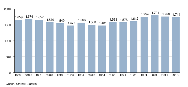
Population development
The population development of the Niederwaldkirchen community has been analogous to the population development of the Rohrbach district since 1869. The population initially fell by around 10 percent between 1869 and 1923, then stagnated until the middle of the 20th century and then increased again until the beginning of the 1990s. Since then the population of Niederwaldkirchen has stagnated. Overall, the population of the municipality rose by only 5 percent between 1869 and 2013. The level of emigration was essential for the development of the population in the last few decades, while the birth balance was strongly positive. While a very high birth surplus was achieved in the municipality in the 1970s, the number of inhabitants rose only slightly due to the strong emigration. After emigration had decreased to almost zero in the 1980s, the municipality was also able to show a strong increase in population. In the 1990s, the birth surplus halved compared to the previous decades, while emigration increased again. Since the turn of the millennium, emigration has increased again, which has led to a decline in the number of inhabitants in recent years. Although the birth surplus also rose, it was less pronounced than emigration.
Culture and sights
Personalities
- Josef Eidenberger (1899–1991), painter
- Anna-Maria Hochhauser (* 1956), General Secretary of the Austrian Chamber of Commerce
- Sabine Lindorfer (* 1977), Miss Austria
- Bernhard Rammerstorfer (* 1968), author and film producer
- Josef Reiter (* 1959), Austrian former judoka and three-time participant in the Olympic Games
Web links
- 41323 - Niederwaldkirchen. Community data, Statistics Austria .
- Further information about the municipality of Niederwaldkirchen can be found on the geographic information system of the federal state of Upper Austria .
Individual evidence
- ↑ a b Province of Upper Austria: Mapping of natural areas in Upper Austria. Landscape survey of the municipality of Niederwaldkirchen. Final report, Kirchdorf
- ↑ Statistics Austria: Population on January 1st, 2020 by locality (area status on January 1st, 2020) , ( CSV )
- ^ State of Upper Austria coat of arms of the Niederwaldkirchen community
- ↑ State of Upper Austria ( page no longer available , search in web archives ) Info: The link was automatically marked as defective. Please check the link according to the instructions and then remove this notice. Local council elections in Niederwaldkirchen from 1945
- ^ Province of Upper Austria election results in mayoral elections
- ^ Province of Upper Austria Mayor of the Niederwaldkirchen community since 1850
- ^ State of Upper Austria State election results in Niederwaldkirchen from 1973
- ↑ a b Province of Upper Austria ( Memento of the original from November 29, 2014 in the Internet Archive ) Info: The archive link was inserted automatically and has not yet been checked. Please check the original and archive link according to the instructions and then remove this notice. Population levels in Upper Austria in comparison by citizenship
- ↑ Statistics Austria: Population by religion and federal states 1951 to 2001 (accessed on October 2, 2013)
- ↑ a b c Statistics Austria community data from Niederwaldkirchen
- ↑ a b Province of Upper Austria ( Memento of the original from October 29, 2013 in the Internet Archive ) Info: The archive link was automatically inserted and not yet checked. Please check the original and archive link according to the instructions and then remove this notice. Resident population in Upper Austria compared by age group

Aigen-Schlägl | Altenfelden | Arnreit | Atzesberg | Eggplant | Haslach an der Mühl | Helfenberg | Hofkirchen im Mühlkreis | Hörbich | Julbach | Kirchberg ob der Donau | Klaffer am Hochficht | Kleinzell im Mühlkreis | Kollerschlag | Lembach im Mühlkreis | Lichtenau im Mühlkreis | Nebelberg | Neufelden | Neustift im Mühlkreis | Niederkappel | Niederwaldkirchen | Oberkappel | Oepping | Peilstein in the Mühlviertel | Parish churches in the Mühlkreis | Putzleinsdorf | Rohrbach Mountain | St. Johann am Wimberg | St. Martin im Mühlkreis | St. Oswald near Haslach | St. Peter am Wimberg | St. Stefan-Afiesl | Ortisei in the Mühlkreis | St. Veit im Mühlkreis | Sarleinsbach | Schwarzenberg am Böhmerwald | Ulrichsberg