
Rohrbach district
| location | |
|---|---|
  |
|
| Basic data | |
| state | Upper Austria |
| NUTS III region | AT-313 |
| Administrative headquarters | Rohrbach mountain |
| surface | 817 km² |
| Residents | 56,545 (January 1, 2020) |
| Population density | 69 inhabitants / km² |
| License Plate | RO |
| District Commission | |
| District chief | Wilbirg Mitterlehner |
| website | www.bh-rohrbach.gv.at |
| map | |
  |
|
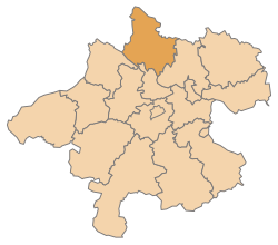
The Rohrbach district is a political district in the province of Upper Austria .
It is the northernmost district in the country and belongs to the Mühlviertel .
geography

The district borders Germany to the west and the Czech Republic to the north . In the east it borders on the Urfahr-Umgebung district , in the south on the districts of Eferding , Grieskirchen and Schärding .
The city of Rohrbach-Berg is the seat of the district administration .
The market town of Ulrichsberg has the largest area with 56.9 km² . Until April 30, 2015, the most populous municipality was the market town of St. Martin im Mühlkreis in the south . Since May 1st, 2015 the new municipality Rohrbach-Berg has the most inhabitants.
history
The Rohrbach district was established in 1868.
On May 1, 2015, the municipalities of Aigen im Mühlkreis and Schlägl were merged to form the new market town of Aigen-Schlägl and Berg bei Rohrbach and Rohrbach in Upper Austria to form the new municipality of Rohrbach-Berg .
On January 1, 2018, the municipality of Schönegg became part of the municipality of Vorderweissenbach , the former municipality area thus became part of the Urfahr-Umgebung district.
On 1 January 2019, the municipalities were St. Stefan am Walde and Afiesl the new municipality of St. Stefan Afiesl merged and the community Ahorn after Helfenberg incorporated.
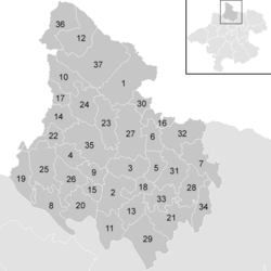
Administrative division
The district covers 817.19 km² and has been divided into 37 communities since 2019 , including a city and 15 market communities.

- The population is from January 1st, 2020.
| local community | location | Ew | km² | Ew / km² | Judicial district | region | Type
|
photo | Metadata |
|---|---|---|---|---|---|---|---|---|---|
Aigen-Schlägl
|

|
3,241 | 45.87 | 71 | Rohrbach | market community
|

|
Acc. To code: 41343 |
|
Altenfelden
|

|
2,250 | 26.43 | 85 | Rohrbach | market community
|

|
According to code: 41304 |
|
Arnreit
|

|
1,136 | 20.32 | 56 | Rohrbach | local community
|

|
According to code: 41305 |
|
Atzesberg
|

|
437 | 12.68 | 34 | Rohrbach | local community
|
According to code: 41306 |
||
Eggplant
|

|
556 | 12.52 | 44 | Rohrbach | local community
|

|
Acc. To code: 41307 |
|
Haslach an der Mühl
|

|
2,564 | 12.41 | 207 | Rohrbach | market community
|

|
Acc. To code: 41309 |
|
Helfenberg
|

|
1,541 | 22.67 | 68 | Rohrbach | local community
|

|
Acc. To code: 41345 |
|
Hofkirchen in the Mühlkreis
|

|
1,507 | 22.59 | 67 | Rohrbach | market community
|

|
According to code: 41312 |
|
Hörbich
|

|
398 | 11.22 | 35 | Rohrbach | local community
|

|
Acc. To code: 41311 |
|
Julbach
|

|
1,540 | 21.77 | 71 | Rohrbach | local community
|

|
Acc. To code: 41313 |
|
Kirchberg above the Danube
|

|
1,045 | 21.27 | 49 | Rohrbach | local community
|

|
According to code: 41314 |
|
Klaffer on the Hochficht
|

|
1,298 | 27.99 | 46 | Rohrbach | local community
|

|
According to code: 41315 |
|
Kleinzell in the Mühlkreis
|

|
1,650 | 16.15 | 102 | Rohrbach | local community
|

|
Acc. To code: 41316 |
|
Kollerschlag
|

|
1,516 | 17.47 | 87 | Rohrbach | market community
|

|
According to code: 41317 |
|
Lembach in the Mühlkreis
|

|
1,523 | 7.98 | 191 | Rohrbach | market community
|

|
Acc. To code: 41318 |
|
Lichtenau in the Mühlkreis
|

|
484 | 9.91 | 49 | Rohrbach | local community
|
According to code: 41319 |
||
Nebelberg
|

|
638 | 9.15 | 70 | Rohrbach | local community
|
Acc. To code: 41320 |
||
Neufelden
|

|
1,249 | 9.8 | 127 | Rohrbach | market community
|

|
According to code: 41321 |
|
Neustift in the Mühlkreis
|

|
1,460 | 20.4 | 72 | Rohrbach | local community
|

|
Acc. To code: 41329 |
|
Niederkappel
|

|
983 | 22.42 | 44 | Rohrbach | local community
|

|
Acc. To code: 41322 |
|
Niederwaldkirchen
|

|
1,835 | 28.26 | 65 | Rohrbach | market community
|

|
Acc. To code: 41323 |
|
Oberkappel
|

|
722 | 12.18 | 59 | Rohrbach | market community
|

|
According to code: 41324 |
|
Oepping
|

|
1,521 | 23.01 | 66 | Rohrbach | local community
|

|
According to code: 41325 |
|
Peilstein in the Mühlviertel
|

|
1,541 | 23.24 | 66 | Rohrbach | market community
|

|
According to code: 41326 |
|
Parish churches in the Mühlkreis
|

|
1,449 | 31.15 | 47 | Rohrbach | local community
|

|
Acc. To code: 41327 |
|
Putzleinsdorf
|

|
1,541 | 22.06 | 70 | Rohrbach | market community
|

|
Acc. To code: 41328 |
|
Rohrbach mountain
|

|
5,219 | 37.94 | 138 | Rohrbach | urban community
|

|
According to code: 41344 |
|
Sankt Johann am Wimberg
|

|
998 | 19.72 | 51 | Rohrbach | local community
|

|
According to code: 41331 |
|
Sankt Martin im Mühlkreis
|

|
3,774 | 34.88 | 108 | Rohrbach | market community
|

|
According to code: 41332 |
|
Sankt Oswald near Haslach
|

|
492 | 8.13 | 61 | Rohrbach | local community
|

|
Acc. To code: 41333 |
|
Sankt Peter am Wimberg
|

|
1,746 | 23.37 | 75 | Rohrbach | market community
|

|
Acc. To code: 41334 |
|
|
St. Stefan-Afiesl
|

|
1.108 | 29.58 | 37 | Rohrbach | local community
|
According to code: 41346 |
||
Ortisei in the Mühlkreis
|

|
644 | 15.36 | 42 | Rohrbach | local community
|
Acc. To code: 41336 |
||
Sankt Veit in the Mühlkreis
|

|
1,247 | 16.33 | 76 | Rohrbach | local community
|

|
According to code: 41337 |
|
Sarleinsbach
|

|
2,272 | 36.86 | 62 | Rohrbach | market community
|

|
Acc. To code: 41338 |
|
Schwarzenberg in the Bohemian Forest
|

|
570 | 27.21 | 21st | Rohrbach | local community
|
.JPG)
|
According to code: 41341 |
|
Ulrichsberg
|

|
2,850 | 56.9 | 50 | Rohrbach | market community
|

|
According to code: 41342 |
Focus
The main area of the Rohrbach district is in the Götzendorf cadastral community , Oepping community ( ⊙ ).
Population development
Data including the former municipality of Schönegg (= area status 2017).

Web links
Individual evidence
- ↑ Provincial Law Gazette for Upper Austria No. 28/2015
- ↑ Provincial Law Gazette for Upper Austria No. 29/2015
- ↑ 85. Ordinance of the Upper Austria. State government regarding the unification of the communities Schönegg and Vorderweißbach in the LGBl for Upper Austria, issued on November 30, 2017
- ↑ Provincial Law Gazette for Upper Austria No. 82/2018
- ↑ Provincial Law Gazette for Upper Austria No. 83/2018
- ↑ Statistics Austria - Population at the beginning of 2002–2020 by municipalities (area status 01/01/2020)
- ↑ center point
Statutory cities: Linz | Steyr | catfish
Political districts: Braunau am Inn | Eferding | Free City | Gmunden | Grieskirchen | Kirchdorf | Linz-Land | Perg | Ried im Innkreis | Rohrbach | Schärding | Steyr-Land | Urfahr environment | Vöcklabruck | Catfish Land
Coordinates: 48 ° 34 ' N , 13 ° 59' E