
Nebelberg
|
Nebelberg
|
||
|---|---|---|
| coat of arms | Austria map | |
 |
|
|
| Basic data | ||
| Country: | Austria | |
| State : | Upper Austria | |
| Political District : | Rohrbach | |
| License plate : | RO | |
| Surface: | 9.15 km² | |
| Coordinates : | 48 ° 38 ' N , 13 ° 51' E | |
| Height : | 695 m above sea level A. | |
| Residents : | 638 (January 1, 2020) | |
| Postal code : | 4155 | |
| Area code : | 07287 | |
| Community code : | 4 13 20 | |
| NUTS region | AT313 | |
| Address of the municipal administration: |
Nebelberg 50 4155 Nebelberg |
|
| Website: | ||
| politics | ||
| Mayor : | Markus Steininger ( SPÖ ) | |
|
Municipal Council : (2015) (13 members) |
||
| Location of Nebelberg in the Rohrbach district | ||
  |
||
| Source: Municipal data from Statistics Austria | ||

Nebelberg is a municipality in Upper Austria in the Rohrbach district in the upper Mühlviertel with 638 inhabitants (as of January 1, 2020). The responsible judicial district is Rohrbach in Upper Austria .
geography
Nebelberg lies at 695 m above sea level. A. in the Upper Mühlviertel or in the natural history landscape of the southern Bohemian Forest foothills . The extension is 3.9 km from north to south, 4.8 km from west to east, the total area is 9.2 km², making the municipality the fourth smallest in the district. In 2001, 72.8% of the municipal area was covered by agricultural land, 22.8% was forested. Gardens, bodies of water, construction areas and other areas only made up around 4% of the municipal area. Neighboring communities are Julbach in the north, Peilstein in the Mühlviertel in the east and Kollerschlag in the south. The state border with Germany runs in the north , with Nebelberg bordering the district of Passau .
Geology and soils
The landscape of the municipality is part of the Bohemian Massif, which goes back to a very old mountain range that was created by the Variscan mountain formation in the Paleozoic ( Carboniferous ). After the strong erosion of the former high mountains, the crystalline basement was abolished by several hundred meters during the Alpidic mountain formation in the Tertiary , causing fractures and faults. Subsequently, sediments were deposited in the Tertiary and Quaternary periods . The municipality is characterized by flat, low mountain ranges that are only more pronounced towards the Šumava main ridge. The dominant rocks in the municipality are older, coarse-grained granites of the Weinsberger granite type and younger granites of the Mauthausen type. Weinsberger granite is one of the first magma series to solidify during the folding of the mountains, has a typical coarseness and causes a restless landscape with rapid alternation of peaks and valleys.
The type of soil in the municipal area is silicate brown earth that has formed on the granites and gneisses of the Bohemian Massif. The soils are light to very light, whereby the quality of the soil depends on the depth and the water supply. The different grain sizes of the original rock also determine whether the site is water-rich or dry. The soils are generally poor in nutrients and consist of loamy sand or sandy loam. The humus form of the dry locations is mild, under normal conditions there is gauze. It can also be found in the valley area along the Great Mühl Gley , which also occurs in the area of waterlogged springs, ditches, hollows and at the foot of the slope. There is also Podsol along the Steinernen Mühl, the Leitenmühlbach and the Lanitzbach .
Landscape and vegetation
The municipality can be roughly divided into two parts. In the north there is forest-dominated mountainous land, in the rest of the municipality there is an agricultural landscape with residual structure close to settlement. The forest-dominated mountainous region is predominantly covered by large-scale coniferous forest, and there is also a small deciduous forest. In addition, there is mainly intensively used grassland. The only structural elements that have survived are local woodland along the border stream, which forms the western boundary of the municipality and runs open as a structureless channel. There are also two small unstructured fish ponds on the edge of the forest. The rest of the municipality is dominated by an agricultural landscape, with only medium to small-scale forest areas covered with coniferous and mixed forest. In addition, there is a large number of smaller hardwood forests as well as small and large afforestation areas.
Large areas are used intensively for agricultural use, mainly permanent grassland with preserved striped meadows typical of the landscape. The structural elements consist of a large number of narrow but largely species-poor hedges as well as a few orchards on the outskirts of the settlement. Extensive grassland that is significant in terms of nature conservation is limited to small residual areas.
Community structure
| District | 2001 | 2011 |
|---|---|---|
| Heinrichsberg | 174 | 182 |
| Nebelberg | 184 | 153 |
| Stift am Grenzbach | 137 | 164 |
| Vordernebelberg | 146 | 120 |
The municipality Nebelberg is congruent with the cadastral municipality Nebelberg, whereby the municipality is divided into four districts. The main town of the municipality is the village of Nebelberg ( 695 m above sea level ). It is located in the south of the municipality on Nebelberger Bezirksstrasse (L 1553). In addition to the actual village, Nebelberg also includes the Nebelbergermühle weekend house, the Pfeilmühle single house, the Schmidl farm and the Spielberg Rotte in the southwest. In 2001 the district had 44 buildings, two workplaces and 20 agricultural and forestry businesses.
The village of Vordernebelberg ( 720 m above sea level ) is located south-east of Nebelberg or in the south-east of the municipality . The desert areas Höllhäusl and Schopper are also counted as part of Vordernebelberg, with Höllhäusl lying between Vordernebelberg and Nebelberg and Schopper north of Vordernebelberg. In 2001 Vordernebelberg comprised 36 buildings, two workplaces and 17 agricultural and forestry businesses. In the center of the municipality or north of Nebelberg is the scattered settlement "Stift am Grenzbach" ( 670 m above sea level ) with the Jagawirt inn and the List hunting lodge. In 2001 the scattered settlement had 46 buildings, two workplaces and 18 agricultural and forestry operations. The northernmost district is the scattered settlement Heinrichsberg ( 681 m above sea level ), which in 2001 had 44 buildings, a place of work and 25 agricultural and forestry operations.
The municipality includes the following localities (population in brackets as of January 1, 2020):
- Heinrichsberg (181)
- Fog Mountain (145)
- Stift am Grenzbach (204)
- Front Fog Mountain (108)
history
Originally located in the eastern part of the Duchy of Bavaria, the place belonged to the Duchy of Austria since the 12th century. Since 1490 it has been assigned to the Principality of Austria ob der Enns .
Since 1918 the place belongs to the federal state of Upper Austria. After the annexation of Austria to the German Reich on March 13, 1938, the place belonged to the Gau Oberdonau . In 1945 Upper Austria was restored.
"I tell Otto the Piber and tell everyone who is now opposite and who will be future and see or hear this letter that ..."
With these words in the contract of November 11, 1296, Otto the Piber sold to the bishop Bernhart von Passau, or the Engelszell monastery, his village at "Eppenberg" with all its accessories. The name Eppenberg (= Nebelberg) comes from the founder of the village of Nebelberg - Graf Eppo (= shortened form for Eberhard) von Formbach. This noble family of Formbachers had large estates in what is now Austria and is likely to have established the first "settlements" in our area.
The Nebelberg community became aware of the historical event in the course of the exhibition for the opening of the official building. A short chronicle of the Nebelberg community was presented at this exhibition. Through this research one came across the historical local dictionary of Konrad Schiffmann. He created this directory in painstaking detail, referring to the document of November 11, 1296.
A trade route (Schiffl, Schopper) from the Danube to the Vltava led through today's municipality of Nebelberg (find from the Stone Age near Vorderschiffl). The clearing and settlement was carried out by the highly free Falkensteiners in the 13th and 14th centuries. After 1300 the area came to the Passau regional court of Velden (= Neufelden).
Nebelberg was first mentioned in documents in 1296. 1467 is written for the first time from the front Epelberg and from the rear Epelberg (literature: Jahrbuch Mus. 1909, page 39). Further written mentions: 1537 Empmperg - Urbar zu Falkenstein, f. 50 and 53; 1581 Eppenberg - Land of Rannariedl; 1787 Eberberg - protection card.
During the peasant revolt from 1595 to 1597, soldiers of the district judge were slain near Nebelberg. In the War of Succession from 1701 to 1704, entrenchments were raised on the border. The Donabauer chapel is a reminder of the passage of the French.
Nebelberg derives its name from the founder of the two localities of Vorder- and Hinternebelberg, Count Eppo (Eberhard von Windberg) Formbach in Lower Bavaria. Eppo had large estates in the Upper Mühlviertel. He died childless in St. Florian in 1110. It can therefore be assumed that Oepping and parts of the localities of Vorder- and Hinternebelberg came into being before 1100. In the parish registers of Peilstein, which are available from 1612, the place names were spelled almost correctly and it says "in the front or in the rear Öppl- or Epplberg". The lack of understanding and the indifference of former office clerks turned the Epplberg into a mountain of fog.
The scattered settlement Heinrichsberg derives its name from the Hörleinsbergers, who were mentioned for the first time in the upper Mühlviertel around 1370. They came from the Herleinsbergerhof in the Rohrbach parish. From 1421 to 1503 they owned Tannberg and Peilstein as pledges. When the parish Kollerschlag was founded in 1786, part of Heinrichsberg - to which all the houses of Stift am Grenzbach belonged to the right of Stiftholz - was incorporated into the village of Stift am Grenzbach, so that the two villages had the same number of houses.
Like all neighboring communities, the Nebelberg community was founded after the liberation of the peasants in 1848.
Theresia Lauß (* 1893), who was born in Vordernebelberg, died in an end- stage crime in 1945 . On May 2, 1945, two Volkssturm men in Reichersberg shot the Augustinian canon Rupert Haginger (* 1898) from Mehrnbach and Theresia Lauß (* 1893), who was employed as a monastery manager. A white flag was waving at the house of the Lauß sisters (Reichersberg No. 100, not far from the monastery ) . In the act, the Volkssturm men invoked the motto of Gauleiter Eigruber : "If you capitulate cowardly, you will be shot dead."
politics
Municipal council
The municipal council as the highest body of the municipality has 13 seats and is elected every six years in the course of Upper Austria-wide municipal council elections.
The strongest parliamentary group in Nebelberg's municipal council has always been the ÖVP, which was the only parliamentary group to stand for in 1973 and thus achieved 100%. From 1979 the ÖVP, the SPÖ and the Freedom Party of Austria (FPÖ) ran as candidates , but the ÖVP was able to achieve between 72.3 and 79.6% in the following elections. During this period, the SPÖ was always in second place with 12.5 to 20.6%, the FPÖ reached 6.9 to 8.8%. The FPÖ has not participated in the election since 2003. As a result, the SPÖ was able to gain significantly more votes. In 2003 the ÖVP came to 65.5%, the SPÖ to 34.5%. In the last municipal council election in 2009, the ÖVP came up with 66.5% or nine seats. The SPÖ achieved 33.5% and four seats and thus its second-best result to date.
The 2015 election brought the following results:
- ÖVP: 8 mandates
- SPÖ: 5 seats
mayor
The mayor has been determined by direct election since 1997 , with no absolute majority for a candidate in a runoff election . Josef Märzinger (ÖVP) was elected as the first mayor in 1997 by the community citizens with 81.2%. In 2001 he was replaced by Otto Pfeil, who was confirmed with no opposing candidate in the direct mayor election in 2003 without opposing candidates. In 2009 he received 70.4%, his SPÖ opponent 29.6%. In the 2015 election, Markus Steininger (SPÖ) was elected mayor. Deputy Mayor has been DI Johann Scharinger since 2015, who is provided by the ÖVP.
coat of arms
Official description of the municipal coat of arms ( blazon ):
"Above a three-mountain in silver split six times by green and gold in an arched cut, a black-clad right arm growing out of the left edge of the shield with a red, inclined 'Hauptmannstab' ( Hapsteck )."
The municipality colors are yellow. Green yellow.
The award of the municipal coat of arms and approval of the municipal colors set by the municipal council on March 20, 1992, took place by resolution of the Upper Austrian provincial government on July 20, 1992.
The coat of arms motif is a turned wooden stick with which important community news and invitations are still passed from house to house in the villages of Heinrichsberg and Stift am Grenzbach. The piece of paper with the message is attached to the thicker end of the "Hapsteck" with two nails and looks like a small flag. - The municipality is located on the flat southern slope of the Schifflerberg, which reaches the highest elevation near Nebelberg with the Eppoberg ( 752 m above sea level ). The green and gold arched intersections in the Dreiberg are intended to express the typical striped land form found in the municipality; Courtyard and house fields are characteristic of the heavily hilly area in the northern parts of the Mühlviertel. - Design of the coat of arms: Herbert Erich Baumert, Linz.
population
In 2013, 632 people lived in the municipality of Nebelberg, making Nebelberg the tenth smallest of the 42 municipalities in the district. With a population density of 69 inhabitants / km², Nebelberg 2013 was in the upper middle field in the Rohrbach district. At the end of 2001 97.2% of the population were Austrian citizens (Upper Austria 92.8%, Rohrbach district 96.9%), by the beginning of 2013 the value had changed to 97.9% (Upper Austria 91.1%, Rohrbach district 96, 9%) hardly. In 2013, only 13 foreigners were counted in the municipality, 100% of whom came from the EU-14 countries. Those 55 people who were not born in Austria also had their country of birth in one of the EU countries. In 2001, 97.3% of the population (Upper Austria: 79.4%) professed to be a member of the Roman Catholic Church , 0.9% were without confession, 0.5% were Protestants.
The average age of the community population in 2001 was slightly below the national average. 20.7% of the residents of Lembach were younger than 15 years (Upper Austria: 18.8%), 62.9% between 15 and 59 years old (Upper Austria: 61.6%). The proportion of residents over 59 years of age was 16.4%, well below the national average of 20.2%. As a result, the average age of the population of Nebelberg changed in all segments. The proportion of people under the age of 15 fell to 16.9% as of January 1, 2013, while the proportion of people between 15 and 59 years of age increased significantly to 72.0%. In contrast, the proportion of people over 59 years of age fell to 11.1%. In 2001, 52.3% of the residents of Nebelberg were single, 42.3% married, 4.8% widowed and 0.6% divorced by marital status.
Population development
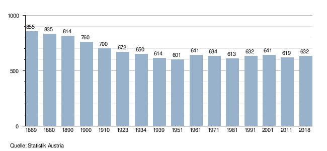
The municipality of Nebelberg recorded a continuous loss of population between the late 19th century and the middle of the 20th century. Only in the second half of the 20th century was there a temporary increase in population. Initially, the population began to rise for the first time in the 1950s, but then the population began to stagnate or only grow slightly. Since 1960, the population has therefore moved between a very narrow range of around 610 and 640 inhabitants. For decades, the population development of the municipality has been in the area of tension between a negative balance of migration or emigration and a positive birth balance or a birth surplus.
Economy and Infrastructure
Agriculture and Forestry
In 2010 the statistics showed 48 agricultural and forestry holdings for the municipality of Nebelberg. These included 17 full-time businesses, 25 part-time businesses and six communities of people. The total number of establishments had fallen sharply by 14 establishments or 23% compared with 1999, with the number of main commercial establishments in particular falling sharply. In 2010, the farms cultivated a total of 864 hectares of land, with 64% of the area being farmed by full-time farmers and 28% by part-time farmers. The average area of full-time farmers was 33 hectares, around half of the Upper Austrian average.
traffic
There is no higher-ranking street in the municipality. The Nebelberger Bezirksstraße L 1553, which connects Nebelberg in the south with Kollerschlag and in the north with Julbach, provides the connection to the neighboring communities. There is only one municipal road to Peilstein in the Mühlviertel, but in this neighboring municipality there is a connection to Böhmerwald Straße B 38, which in the southeast of the municipality just passes the municipality border. Nebelberg is connected to public transport by bus lines that serve the Nebelberg community very well.
education
The municipality of Nebelberg has a school with the Heinrichsberg elementary school. In the school chronicle of the elementary school, a kind of secondary school in Stift am Grenzbach is first handed down for the period between 1804 and 1842, with lessons being held in private homes. In 1882 the community was allowed to build a formal public elementary school, after which the current schoolhouse was built. The building was completely renovated between 1950 and 1952 and equipped with the first toilet in the Nebelberg community. In 1974/75 the elementary school was completely renovated and rebuilt, and in 1995 the newly built gym was opened.
Web links
- 41320 - Nebelberg. Community data, Statistics Austria .
- More information about the municipality of Nebelberg on the geo-information system of the federal state of Upper Austria .
Individual evidence
- ↑ a b c Province of Upper Austria: Mapping of natural areas in Upper Austria. Landscape elevation Nebelberg. Final report. Kirchdorf an der Krems, 2006 (PDF; 1.7 MB)
- ↑ Statistics Austria: Ortverzeichnis Oberösterreich 2005 p. 265
- ↑ Statistics Austria: Population on January 1st, 2020 by locality (area status on January 1st, 2020) , ( CSV )
- ↑ a b Upper Austria. Document book . tape VI , S. 585 .
-
^ Konrad Schiffmann: Historical place names lexicon of the state of Upper Austria, 2 volumes . Linz 1935. Konrad Schiffmann: Historical place names lexicon of the state of Upper Austria, supplementary volume . Munich / Berlin 1940. TOOLS FOR HISTORICIANS. Institute for History, University of Vienna, accessed on August 31, 2013 .
- ↑ Description of the murder , in: Gottfried Gansinger: National Socialism in the Ried im Innkreis district: Resistance and persecution 1938-1945 , Innsbruck-Wien-Bozen (Studien Verlag) 2016
- ↑ Ernst Gansinger: Places of Remembrance , in: Church newspaper of the Diözese Linz, edition: 2013/18 (April 30, 2013, online )
- ^ Province of Upper Austria (PDF; 209 kB) Local council elections in Nebelberg
- ^ Province of Upper Austria, results of the 2015 elections. Accessed April 26, 2019 .
- ↑ Province of Upper Austria (PDF; 200 kB) Results of mayoral elections
- ↑ MAYOR CHRONICLES. Nebelberg municipality, accessed March 5, 2020 .
- ^ State of Upper Austria, history and geography, coat of arms. Retrieved April 26, 2019 .
- ↑ a b Province of Upper Austria population level overview - nationality Population levels in Upper Austria in comparison according to citizenship
- ↑ Statistics Austria: Population by religion and federal states 1951 to 2001 (accessed on October 2, 2013)
- ↑ a b c d Statistics Austria municipality data from Nebelberg
- ↑ a b Province of Upper Austria population overview - age structure of the residential population in Upper Austria in comparison by age group
- ^ Community Nebelberg elementary school Heinrichsberg

Aigen-Schlägl | Altenfelden | Arnreit | Atzesberg | Eggplant | Haslach an der Mühl | Helfenberg | Hofkirchen im Mühlkreis | Hörbich | Julbach | Kirchberg ob der Donau | Klaffer am Hochficht | Kleinzell im Mühlkreis | Kollerschlag | Lembach im Mühlkreis | Lichtenau im Mühlkreis | Nebelberg | Neufelden | Neustift im Mühlkreis | Niederkappel | Niederwaldkirchen | Oberkappel | Oepping | Peilstein in the Mühlviertel | Parish churches in the Mühlkreis | Putzleinsdorf | Rohrbach Mountain | St. Johann am Wimberg | St. Martin im Mühlkreis | St. Oswald near Haslach | St. Peter am Wimberg | St. Stefan-Afiesl | Ortisei in the Mühlkreis | St. Veit im Mühlkreis | Sarleinsbach | Schwarzenberg am Böhmerwald | Ulrichsberg