
Ulrichsberg
|
market community Ulrichsberg
|
||
|---|---|---|
| coat of arms | Austria map | |
 |
|
|
| Basic data | ||
| Country: | Austria | |
| State : | Upper Austria | |
| Political District : | Rohrbach | |
| License plate : | RO | |
| Surface: | 56.9 km² | |
| Coordinates : | 48 ° 41 ' N , 13 ° 55' E | |
| Height : | 626 m above sea level A. | |
| Residents : | 2,850 (January 1, 2020) | |
| Population density : | 50 inhabitants per km² | |
| Postal code : | 4161 | |
| Area code : | 07288 | |
| Community code : | 4 13 42 | |
| NUTS region | AT313 | |
| Address of the municipal administration: |
Market 20 4161 Ulrichsberg |
|
| Website: | ||
| politics | ||
| Mayor : | Wilfried Kellermann ( ÖVP ) | |
|
Municipal Council : (2015) (25 members) |
||
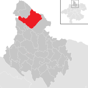
| Location of Ulrichsberg in the Rohrbach district | ||
  |
||
| Source: Municipal data from Statistics Austria | ||

Ulrichsberg is a market town in Upper Austria in the Rohrbach district in the upper Mühlviertel with 2850 inhabitants (as of January 1, 2020). The community is located in the judicial district of Rohrbach .
geography
Ulrichsberg lies at an altitude of 626 m above sea level. A. in the north of the Rohrbach district in the upper Mühlviertel . The community is located on the Great Mill on the southern edge of the Bohemian Forest . In terms of the nature conservation spatial division, the Bohemian Forest spatial unit extends over the northeast of the municipality, the rest of the municipality belongs to the southern Bohemian Forest foothills . The extension is from north to south 10.3 km, from west to east 12.2 km, the total area covers 56.95 km². Ulrichsberg is the largest municipality in the district. 51.8% of the area of Ulrichsberg is forested, 44.7% of the area is used for agriculture. In comparison with the federal state of Upper Austria, Ulrichsberg is much more forested than the regional average (Upper Austria: 36.9 percent) or there is significantly less agricultural land (Upper Austria: 49.3 percent). The proportion of other uses (construction areas, gardens, bodies of water and others) is 4.5 percent, below the Upper Austrian average of 13.8 percent. Neighboring communities are Aigen-Schlägl in the east and south-east, Schlägl and Peilstein in the Mühlviertel in the south and Julbach in the south-west. In the west Ulrichsberg borders on the German municipality of Breitenberg ( Passau district ), in the north on Klaffer am Hochficht and in the northeast on the Czech municipality Horní Planá ( Okres Český Krumlov ). In Schöneben there is a border crossing to the Czech Republic (only for vehicles up to 3.5 tons).
Geology and soils
The landscape of the municipality is part of the Bohemian Massif, which goes back to a very old mountain range that was created by the Variscan mountain formation in the Paleozoic ( Carboniferous ). This resulted in various granites and gneisses. Furthermore, between the Bohemian Forest and the valley of the Große Mühl, the so-called pile fault from northwest to southeast consists of easily erodible mylonites . To the northwest of this fault there is predominantly Eisgarner granite and Weinsberger granite, while smaller areas at the northern tip also show Cordoerot paragneiss. To the south there is mainly Schlieren granite as well as Mauthausen granite and Weinsberg granite. In the area of the Große Mühl, a strip of river deposits has formed, with typical weathering phenomena such as wool sack weathering predominating, which led to the formation of block castles, block litter and boulders.
The soils in the municipal area are characterized by a lack of nutrients and a high proportion of potassium. They also have a poor phosphorus and calcium supply. The soil type is loamy sand or sandy loam. The soil quality depends on the depth and the water supply, with the grain size of the rock deciding whether the site is water-rich or dry. The rocky brown earth is the most important type of soil in the area, it is found below 1000 m above sea level as low-base to acidic, shallow to medium-sized soil that was formed on solid or debris. Furthermore, loose sediment brown earth has formed on gravelly or fine-grained starting material. However, due to litter use and spruce forests, real brown soils without signs of podsolic dynamics have become rare. Above 1000 m above sea level, podsoles and semi-podsoles in particular were formed when there was high rainfall, with the coniferous forests also having an acidifying effect. Gley exists mainly in the area of springs, streams, ditches, hollows and at the foot of slopes, with wet, acidic meadows dominating here. Other types of soil that occur are pseudogley , bog soils and moor soils in the area of cold-air lakes in small depressions on streams or on locations without drainage as well as tendril-like soils over block debris.
Community structure
The municipality includes the following localities (population in brackets as of January 1, 2020):
- Berdetschlag (110)
- Breitenstein (2)
- Lock pick (24)
- Erlet (45)
- Fuchslug (19)
- Hintenberg (300)
- Kandlschlag (28)
- Lichtenberg (215)
- Muhlwald (23)
- Odenkirchen (42)
- Salnau (166)
- Schindlau (294)
- Schöneben (32)
- Side flap (147)
- Sun Forest (0)
- Stangl (119)
- Stollnberg (103)
- Ulrichsberg (1124)
- Zaglau (57)
history
Originally under the feudal sovereignty of the Passau bishops , the place, first mentioned in 1325, was during the Napoleonic Wars several times a. a. occupied by Bavaria . Since 1765 the place finally belongs to Upper Austria.
After the annexation of Austria to the German Reich on March 13, 1938, the place belonged to the Gau Oberdonau . After 1945 the restoration of Upper Austria took place.
Ulrichsberg was part of the judicial district of Aigen from 1850 . In 2003 the judicial district of Aigen was dissolved and the municipality was assigned to the Rohrbach judicial district.
population
Population structure
In 2013, there were 2,900 people in the Ulrichsberg community, making the community the second largest of the district's 42 communities. With 51 inhabitants per km², Ulrichsberg was in the lower middle field of the municipalities in the district in terms of population density. At the end of 2001 97.5 percent of the population were Austrian citizens (Upper Austria 92.8 percent, Rohrbach district 96.9 percent), by the beginning of 2013 the value had fallen slightly to 973 percent (Upper Austria 91.1 percent, Rohrbach district 96.9 percent) ) on. A total of 79 foreigners were counted in the municipality in 2013, 85 percent of whom came from EU countries. A total of 162 community residents were born abroad, with 87 percent also having a country of birth in another EU country. In 2001, 96.5 percent of the population committed to the Roman Catholic Church (Upper Austria: 79.4 percent), 1.7 percent were without confession and 0.4 percent each were Protestant or Islamic.
The average age of the community population in 2001 was roughly the national average. 19.2 percent of the residents of Ulrichsberg were younger than 15 years (Upper Austria: 18.8 percent), 60.1 percent between 15 and 59 years old (Upper Austria: 61.6 percent). The proportion of residents over 59 years of age was 20.7 percent, slightly above the national average of 20.2 percent. As a result, the average age of the population of Ulrichsberg changed in all segments. The proportion of people under the age of 15 fell to 13.4 percent as of January 1, 2013, while the proportion of people between the ages of 15 and 59 increased significantly to 66.7 percent. The proportion of people over 59 years of age fell only slightly to 19.9 percent. According to their marital status, in 2001 45.9 percent of the residents of Ulrichsberg were single, 44.5 percent married, 6.7 percent widowed and 2.9 percent divorced.
Population development
The population of the Ulrichsberg community fluctuated little between 1869 and 2013. The number of inhabitants in 2013 was only five percent higher than in 1869 and in the years in between moved within a narrow corridor of around 2,599 to 3,100 inhabitants. The lowest population level was measured in the municipality in 1923 with 2,536 inhabitants, the highest in 1991 with 3,111 inhabitants. In comparison with the Rohrbach district, the population of Ulrichsberg developed on average or slightly above it, but in comparison the federal state of Upper Austria experienced almost a doubling of the population in the same period. In the 1970s to 1990s, Ulrichsberg had a strong surplus of births combined with strong emigration, whereby the surplus of births was able to offset emigration. After the turn of the millennium, however , the birth balance turned negative, while the migration balance was only slightly positive. As a result, the municipality lost four percent of its population between 2001 and 2011, and the decline in population continues to this day.

Politics and elections
Municipal council
The municipal council as the highest body of the municipality has 25 seats and is elected every six years in the course of Upper Austria-wide municipal council elections. The municipal board consists of seven members, with the Austrian People's Party (ÖVP) being represented by the mayor, the vice-mayor and three other members after the municipal council elections in 2009 and thus having an absolute majority in this body. The Social Democratic Party of Austria (SPÖ) and the “Other List Ulrichsberg” each send a further member.
The strongest parliamentary group in Ulrichsberg's municipal council has always been the ÖVP, which since 1945 has always achieved an absolute majority of votes and mandates. The ÖVP always achieved over 60 percent of the votes between 1945 and 1985, and between 1955 and 1985 it even had a two-thirds majority. The ÖVP had its best result in 1961 with 73.1 percent. In the 1991 election, the ÖVP sank to 53.4 percent, its worst result so far, due to the appearance of a citizens' list and the FPÖ's victory. Then it came to 54 to 58 percent. The second strongest party in Ulrichsberg's municipal council has always been the SPÖ, which has had results between 18.4 and 36.0 percent since 1945. The SPÖ had its best result in 1945, its worst in 2009. The FPÖ first appeared in the municipality in the 1979 and 1985 elections, but could not move into the municipal council with around 3 percent each. She only managed to do this in 1991 with 9.1 percent. Then the FPÖ came to election results between 6 and 12 percent. In addition to the parliamentary parties, there was also a list of persons starting in 1991, which came to 8.7 to 13.4 percent. In the municipal council elections in 2009 , the ÖVP achieved 57.8 percent or 15 seats, the SPÖ won 18.4 percent or five seats and had to give up around eight percent. The other list Ulrichsberg (ALU) came to 13.4 percent or three mandates, the FPÖ on 10.5 percent or two mandates. The 2015 election resulted in the following:
- ÖVP: 14 mandates
- FPÖ: 4 mandates
- SPÖ: 4 seats
- ALU: 3 mandates
mayor
The mayor has been determined by direct election since 1997 , with no absolute majority for a candidate in a runoff election . Josef Natschläger (ÖVP) won the first direct election since 1985 with 74.4 percent in the first ballot against the candidates of the SPÖ and FPÖ. In 2002 Wilfried Kellermann (ÖVP) took over the office of Natschläger, whereby Kellermann was able to prevail in the 2003 election with 75.5 percent in the first ballot against the candidate of the SPÖ. In 2009 he won the direct mayor election with 71.1 percent, also in the first ballot against the candidates from the SPÖ and FPÖ. In the 2015 election, Wilfried Kellermann was confirmed in office with 69.8 percent of the votes.
Mayor since 1850:
| Term of office | Surname | Term of office | Surname | Term of office | Surname |
|---|---|---|---|---|---|
| 1850 | Johann Drächsler | 1910-1914 | Kajetan Kagerer | 1955-1985 | Franz Pröll |
| 1850-1861 | Franz X. Langthaler | 1914-1919 | Heinrich Leitner | 1985-2002 | Josef Natschläger |
| 1861-1867 | Schindlau zu Ulrichsberg | 1919-1929 | Kajetan Kagerer | since 2002 | Wilfried Kellermann |
| 1867-1877 | Johann Drächsler jun. | 1929-1938 | Alois Pröll | ||
| 1877-1880 | Georg Loeffler | 1938-1939 | Leopold Samböck | ||
| 1880-1898 | Franz Krenn | 1939-1945 | Ferdinand Hofmann | ||
| 1898-1903 | Georg Reischl | 1945-1946 | Leopold Weikerstorfer | ||
| 1903-1910 | Franz Krenn | 1946-1955 | Franz Roth |
coat of arms
The municipality of Ulrichsberg was awarded the market coat of arms by a resolution of the Upper Austrian provincial government on February 19, 1929. It was designed by Ludwig Hase from Linz and shows Saint Ulrich of Augsburg , the patron saint of the place and the parish, as well as two crossed mallets in the lower half of the shield, which Ulrichsberg identifies as an incorporated parish of Schlägl. The blazon of the coat of arms reads: Humiliated divided; Above in blue, growing out of the dividing line and facing forward, St. Ulrich in episcopal regalia, holding a golden crook with a silver pocket in his left hand, stretching out his right hand blessing; at the bottom split by silver and black with two crossed mallets in alternating colors .
Parish partnership
-
 Baiersdorf in Middle Franconia , Germany , since 1975
Economy and Infrastructure
Transport and infrastructure
Ulrichsberg is connected to the higher-ranking traffic network by Dreisesselbergstraße (L 580), which runs the municipality from southeast to northwest. The Dreisesselbergstraße connects Ulrichsberg with Aigen-Schlägl in the southeast and Klaffer am Hochficht in the northwest. In the area of the market, Ulrichsberger Bezirksstraße (L 1552) branches off from Dreisesselbergstraße to the southwest and connects Ulrichsberg with the neighboring municipality of Julbach. In addition, the Glöckelberger Bezirksstraße (L 1558) branches off to the north at the same intersection and connects Ulrichsberg with the Czech Republic via the villages of Lichtenberg and Schöneben.
Culture and sights

- Vltava view : observation tower with a view of the Vltava reservoir .
- Alpenblick: Lookout tower with a view over the Mühlviertel , with good visibility as far as the Alps .
- Ulrichsberg parish church
- Schöneben Church: built by expellees after the Second World War based on plans by Walter Esch , consecrated in 1962 to Mary on the Flight to Egypt.
- Obernhof or Michaelskapelle : a central building - a round building with a small porch designed in 1694 by the famous Italian architect Carlo Antonio Carlone (who also drafted the plans for the redesign of some Upper Austrian monasteries), completed in 1696. One of the oldest and most beautiful chapels in the upper Mühlviertel. The chapel is located in the Stollnberg district in front of house number 9.
- Ulrichsberg home and culture center: u. a. with a flax room (weaving mill) and a glass museum, is located next to the church
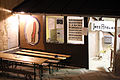
- Jazzatelier Ulrichsberg : Founded in 1973, the club has had its own house in Ulrichsberg since 1986. Jazz concerts, the Ulrichsberger Kaleidophon International Music Festival , film screenings and exhibitions are organized.
sport and freetime
- Union Sportklub Ulrichsberg (sections football , tennis , skiing , fistball )
- Union Golf Club Böhmerwald - 27 hole golf course
- Amusement park Bohemia Park ( archery , soccer golf , disc golf , Swingolf , Crossboccia , bowls , mini golf )
- Ulrichsberg high ropes course
Regular events
- Ulrichsberger Kaleidophon: the international music festival takes place annually in the Ulrichsberg jazz studio.
- Bohemian Forest Fair: takes place every odd year (e.g. 2013) on the first weekend in August.
Kaleidophone 2013

Impressions
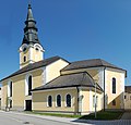
church
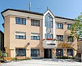
town hall

Ulrichsberg jazz studio

Hintenberg district, with a chapel built in 1830.
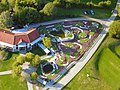
Böhmerwaldpark district Seitelschlag


Personalities
- Florian Josef Pröll OPraem (born July 6, 1913 in Dietrichschlag; † May 19, 1993 in Schlägl), abbot of the Premonstratensian monastery Schlägl (1958–1989)
Individual evidence
- ↑ a b Province of Upper Austria: Mapping of natural areas in Upper Austria. Landscape survey of the Ulrichsberg community. Final report. Attnang-Puchheim 2010
- ↑ Statistics Austria: Population on January 1st, 2020 by locality (area status on January 1st, 2020) , ( CSV )
- ↑ a b Province of Upper Austria ( Memento of the original from November 29, 2014 in the Internet Archive ) Info: The archive link was inserted automatically and has not yet been checked. Please check the original and archive link according to the instructions and then remove this notice. Population levels in Upper Austria in comparison by citizenship
- ↑ Statistics Austria: Population by religion and federal states 1951 to 2001 (accessed on October 2, 2013)
- ^ A b Statistics Austria municipality data from Ulrichsberg
- ↑ a b Province of Upper Austria ( Memento of the original from October 29, 2013 in the Internet Archive ) Info: The archive link was automatically inserted and not yet checked. Please check the original and archive link according to the instructions and then remove this notice. Resident population in Upper Austria compared by age group
- ^ Statistics Austria, A look at the community of Ulrichsberg, population development. Retrieved April 27, 2019 .
- ↑ Province of Upper Austria ( Memento of the original from December 24, 2013 in the Internet Archive ) Info: The archive link was automatically inserted and not yet checked. Please check the original and archive link according to the instructions and then remove this notice. Local council elections in Ulrichsberg from 1945
- ↑ a b Province of Upper Austria, results of the 2015 elections. Accessed April 27, 2019 .
- ^ Province of Upper Austria election results in mayoral elections
- ↑ State of Upper Austria Mayor of the Ulrichsberg community since 1850
- ^ State of Upper Austria coat of arms of the Ulrichsberg community
- ↑ City of Baiersdorf, portrait, partner cities. Retrieved April 27, 2019 .
Web links
- Ulrichsberg on the side of Upper Austria
- 41342 - Ulrichsberg. Community data, Statistics Austria .
- Further information about the municipality of Ulrichsberg can be found on the geographic information system of the federal state of Upper Austria .

Aigen-Schlägl | Altenfelden | Arnreit | Atzesberg | Eggplant | Haslach an der Mühl | Helfenberg | Hofkirchen im Mühlkreis | Hörbich | Julbach | Kirchberg ob der Donau | Klaffer am Hochficht | Kleinzell im Mühlkreis | Kollerschlag | Lembach im Mühlkreis | Lichtenau im Mühlkreis | Nebelberg | Neufelden | Neustift im Mühlkreis | Niederkappel | Niederwaldkirchen | Oberkappel | Oepping | Peilstein in the Mühlviertel | Parish churches in the Mühlkreis | Putzleinsdorf | Rohrbach Mountain | St. Johann am Wimberg | St. Martin im Mühlkreis | St. Oswald near Haslach | St. Peter am Wimberg | St. Stefan-Afiesl | Ortisei in the Mühlkreis | St. Veit im Mühlkreis | Sarleinsbach | Schwarzenberg am Böhmerwald | Ulrichsberg