
Eggplant
|
Eggplant
|
||
|---|---|---|
| coat of arms | Austria map | |
 |
|
|
| Basic data | ||
| Country: | Austria | |
| State : | Upper Austria | |
| Political District : | Rohrbach | |
| License plate : | RO | |
| Surface: | 12.52 km² | |
| Coordinates : | 48 ° 33 ' N , 14 ° 3' E | |
| Height : | 595 m above sea level A. | |
| Residents : | 556 (January 1, 2020) | |
| Population density : | 44 inhabitants per km² | |
| Postal code : | 4171 | |
| Area code : | 07282 | |
| Community code : | 4 13 07 | |
| NUTS region | AT313 | |
| Address of the municipal administration: |
Hollerberg 9 4171 Auberg |
|
| Website: | ||
| politics | ||
| Mayor : | Michael Lehner ( ÖVP ) | |
|
Municipal Council : (2015) (13 members) |
||
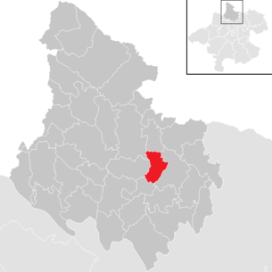
| Location of Auberg in the Rohrbach district | ||
  |
||
| Source: Municipal data from Statistics Austria | ||

Auberg is a municipality in Upper Austria in the Rohrbach district in the upper Mühlviertel with 556 inhabitants (as of January 1, 2020). The responsible judicial district is Rohrbach in Upper Austria .
geography
Auberg lies at 595 m above sea level in the upper Mühlviertel. The extension is 4 km from north to south and 5.4 km from west to east. The total area is 12.5 km². 25.6% of the area is forested and 68.8% of the area is used for agriculture.
The municipality includes the following localities (population in brackets as of January 1, 2020):
- Aubergine (84)
- Harafl (44)
- Hehenberg (98)
- Hollerberg (137)
- Iglbach (146)
- Marbach (47)
coat of arms
Official description of the municipal coat of arms awarded in 1991: In green, two diagonally crossed flags on black poles; the left golden flag with a green hop vine with a leaf and four umbels, the right silver flag with a continuous red cross. The community colors are green and white.
The flag images underline the community's economic and ecclesiastical concerns: the hop vine pays tribute to Auberg as the largest growing area in the Mühlviertel of the most important raw material for beer production alongside barley. The cross flag refers to the Hollerberg branch church consecrated to St. George.
history
Originally located in the eastern part of the Duchy of Bavaria, the place belonged to the Duchy of Austria since the 12th century. Since 1490 it has been assigned to the Principality of Austria ob der Enns .
During the Napoleonic Wars , the place was occupied several times.
Since 1918 the place belongs to the federal state of Upper Austria. After the annexation of Austria to the German Reich on March 13, 1938, the place belonged to the Gau Oberdonau . After 1945 the restoration of Upper Austria took place.
Originally, the community had been part of the Neufelden judicial district since 1850 , but after its dissolution it was assigned to the Rohrbach judicial district on January 1, 2003.
Population development
In 1991 the municipality had 618 inhabitants according to the census. Because of the strong emigration, the population fell to 535 inhabitants by 2001 despite the positive birth balance. From 2001 to 2011, both the birth balance and the migration balance were positive, so that the population rose to 593. By 2019, however, the population had dropped back to 558.
Culture and sights
Unterkagererhof
The Unterkagererhof in the municipality was opened on June 20, 1992 as the Upper Austrian open-air museum "Obermühlviertler Denkmalhof Unterkagerer". The owners are the 42 communities in the Rohrbach district. As a museum operator, the “Obermühlviertler Denkmalhof Unterkagerer” association strives to maintain and manage this cultural gem. The aim of this association is to make the everyday life of the ancestors understandable to the visitors of the Unterkagererhof.
The essential importance of the Unterkagererhof lies in its structural uniqueness which still exists today as it looked more than 100 years ago and sometimes even more than 300 years ago. The renovation and renewal forms that have emerged over time, such as B. Doors and their painting are already museum objects.
Every year there is an extensive cultural program at the Unterkagererhof with readings, concerts, children's theater, witch market and events for the maintenance of customs and old rural handicrafts. There is a small seminar room in the annex.
particularities
|
Cultural event
|
Web links
- 41307 - Auberg. Community data, Statistics Austria .
- Further information about the municipality of Auberg can be found on the geographic information system of the federal state of Upper Austria .
- Homepage of the municipality of Auberg
Individual evidence
- ↑ Statistics Austria: Population on January 1st, 2020 by locality (area status on January 1st, 2020) , ( CSV )
- ^ State of Upper Austria, history and geography, coat of arms. Retrieved April 24, 2019 .
- ^ Statistics Austria, A look at the community of Auberg, population development. Retrieved April 24, 2019 .
- ↑ Homepage Sakuramachis Sunbeng Festival ( Memento of the original from September 27, 2011 in the Internet Archive ) Info: The archive link has been inserted automatically and has not yet been checked. Please check the original and archive link according to the instructions and then remove this notice.

Aigen-Schlägl | Altenfelden | Arnreit | Atzesberg | Eggplant | Haslach an der Mühl | Helfenberg | Hofkirchen im Mühlkreis | Hörbich | Julbach | Kirchberg ob der Donau | Klaffer am Hochficht | Kleinzell im Mühlkreis | Kollerschlag | Lembach im Mühlkreis | Lichtenau im Mühlkreis | Nebelberg | Neufelden | Neustift im Mühlkreis | Niederkappel | Niederwaldkirchen | Oberkappel | Oepping | Peilstein in the Mühlviertel | Parish churches in the Mühlkreis | Putzleinsdorf | Rohrbach Mountain | St. Johann am Wimberg | St. Martin im Mühlkreis | St. Oswald near Haslach | St. Peter am Wimberg | St. Stefan-Afiesl | Ortisei in the Mühlkreis | St. Veit im Mühlkreis | Sarleinsbach | Schwarzenberg am Böhmerwald | Ulrichsberg