
Above sea level


Heights above sea level (also sea or sea level ) are used to indicate the height of geographical and technical objects , in particular of heights of the earth's surface ( terrain , mountain peaks ), of localities and traffic routes. The mean sea level is usually defined as the zero level , which can be determined from long-term observations from special water level stations or is simply determined by definition . In Germany , for example, normal height zero (previously: normal zero ) is used as a reference point .
Sea levels are to be understood as absolute altitude information - in contrast to relative altitude information, which represent altitude differences based on arbitrarily selected reference points.
Sea level as a reference to altitude
Can reference surfaces by means of Geodesy in millimeters to be defined exactly. Different calculation methods ( height definitions ) and different reference heights are used depending on the country or application . Some systems are only of regional significance (e.g. Heligoland Null ) or, like Wiener Null, relate to height definitions derived from river levels. In the 18th and 19th centuries, the application of certain height definitions was mostly extended to the entire national territory . Attempts are being made to standardize these definitions internationally , for example in Europe in the European Height Reference System .
The defined mean value of a coastal level or a datum point in the interior of the country was often used as the zero point for reference heights for land surveys . From here, the official height control points (HFP) distributed over the entire country are connected to a leveling system like a network and thus determined in terms of height. Important examples of such height definitions in Europe are the height of the Amsterdam level established since 1684 , the Kronstadt level (mean value for the years 1825 to 1839), the two height definitions at Molo Sartorio from the years 1875 and 1900 or the Marseille level (mean value for the years 1884 until 1896). With the determination of the zero point of the height reference system, the height information became independent of water level fluctuations of the original level . Only the word level in the name reminds of the dependence on a water level . Examples of reference points in the interior of the country are the former German normal high point in 1879 in Berlin or the Repère Pierre du Niton (on a rock in the port of Geneva ) in Switzerland .
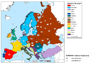
Official elevation systems of selected countries
The differences Δ between the height systems are usually a few centimeters to a few decimeters , and in extreme cases can also be meters.
A conversion between the various systems with a constant value is only possible very imprecisely (> 1 dm ), since the correction value also depends on the position in the height network and, if the height definition is different, also on the height. The latter is particularly important in the high mountains.
| country | designation | Δ 1) for DHHN 92 | Height definition | level | Date point |
|---|---|---|---|---|---|
| Belgium (DNG / TAW) |
meter boven Oostends Peil (m OP) (meter above Ostend gauge) |
−230 cm | Normal height, the Ostend gauge, in contrast to other gauges, does not refer to the mean but to the lowest water level | East End | Ukkel, fixed point GIKMN with 100.174 m TAW |
| Denmark | meter over havets overflade (moh) | −2 cm | orthometric height | From 1891 to 2006 Dansk Normal Nul (DNN GM1891). Since 2002 Dansk Vertical Reference (DVR90) related to Aarhus Cathedral . |
|
Germany ( DHHN ) 2)
|
Meters above sea level (m above sea level)
|
± 0 cm |
Normal height
|
Amsterdam
|
Wallenhorst
|
| Finland | Normal height | Helsinki | Helsinki | ||
France (NGF-IGN69)
|
mètres au-dessus du niveau de la mer (m) (meters above sea level) |
−50 cm | Normal height | Marseille | Marseille
|
| Ireland | meters above sea level (m ASL / m asl) | orthometric height | Malin Head | Malin Head | |
| Italy (Genoa 1942) |
metri sul livello del mare (m slm) (meters above sea level) |
orthometric height | Genoa | Genoa | |
| Japan 3) |
Tōkyō-wan heikin kaimen ( 東京湾 平均 海面 ) (mean sea level [= mean water] of Tokyo Bay ) Tokyo Peil (TP) |
orthometric height | Chiyoda , Tokyo | Nihon suijun genten ( 日本 水準 原点 ), 24.4140 m 3) | |
| Successor states of Yugoslavia :
Bosnia-Herzegovina, Kosovo, North Macedonia, Montenegro, Serbia |
Nadmorska visina ( m / nv , ~ meters above the Adriatic Sea ) | normal orthometric height | Trieste 1900 | ||
| Croatia | Croatian altitude reference system 1971.5 - HVRS71 ( meters above the Adriatic Sea ) | normal-quasi-orthometric height | five different Adriatic levels (Dubrovnik, Split, Bakar, Rovinj and Kopar), introduced on January 1st, 2010 | ||
| Liechtenstein (LN02) | Meters above sea level (m above sea level) | −32 cm | leveled height | Marseille | Repère Pierre du Niton |
| Luxembourg | +1 cm | orthometric height | Amsterdam | Amsterdam | |
| Netherlands (NAP) |
meter boven / onder NAP (m NAP) (meters above / below NAP ) |
−1 cm | orthometric height | Amsterdam | Amsterdam |
| Northern Ireland | Belfast | ||||
| Norway (NN2000) |
meter over havet (moh.) (meters above the sea) |
normal orthometric height | Amsterdam | Amsterdam | |
| Austria (GHA) | Meters above the Adriatic Sea (m above the Adriatic Sea) | −34 cm | orthometric height | Trieste 1875 | Hutbiegl |
| Poland (Kronstadt 2006) | metry nad poziomem morza (m npm) | +14 cm | Normal height | Kronstadt | |
| Portugal (RNGAP) | Nível Médio das Águas do Mar (m NMM) | orthometric height | Cascais | Cascais | |
| Romania | m | Normal height | Constanța | ||
|
Russia (BSW77) Russian Балтийская система высот, (БСВ77) |
wyssota (metry) nad urownem morja ( высота (метры) над уровнем моря ) (height (meters) above sea level) |
+14 cm | Normal height | Kronstadt | Kronstadt |
| Sweden (RH2000) |
Meter över havet (m ö.h.) (meters above the sea) |
Normal height | Amsterdam | ||
| Switzerland (LN02) 4) | Meters above sea level (m above sea level) | −32 cm | leveled height | Marseille | Repère Pierre du Niton |
| Slovakia (Bpv04) |
metrov nad morom (m nm) (meters above sea level) |
Normal height | Kronstadt | ||
| Slovenia (SI-NVN99) | normal orthometric height | Trieste 1900 | Soot | ||
| Spain (REDNAP) |
metros sobre el nivel del mar (msnm) (meters above sea level) |
orthometric height | Alicante | Alicante | |
| Czech Republic (Bpv) |
metrů nad mořem (m nm) (meters above sea level) |
+13 cm | Normal height | Kronstadt | |
| Turkey | normal orthometric height | Antalya | Antalya | ||
| Hungary (EOMA1980) |
Tengerszint feletti magasság (altitude above sea level) |
Normal height | Kronstadt | Nadap | |
|
United Kingdom |
meters above sea level (m ASL / m asl ) |
orthometric height | Newlyn | Newlyn |
- Height " n " according to DHHN92 ≈ " n + 230 cm" according to the Belgian system
- Height " n " according to the Belgian system ≈ " n - 230 cm" according to DHHN92
Cross-border structures
The different height systems in cross-border structures are of particular importance, and errors can also occur. In 2003, for example, the calculated difference of 27 cm for the Hochrhein Bridge was taken into account in principle, but the difference was doubled to 54 cm due to a sign error.
United European Leveling Network (UELN)
With the United European Leveling Network (UELN) (formerly Reseau Européen Unifié de Nivellement (REUN) ), a uniform European system based on the zero point of the Amsterdam level is being created.
Ellipsoidal Height (GPS)
The Global Positioning System (GPS) is used to determine ellipsoidal heights above the reference ellipsoid of the World Geodetic System ( WGS84 ). The ellipsoidal heights in Germany are from 36 m (in Western Pomerania ) to 50 m (in the Black Forest and in the Alps ) higher than the difficult-related heights (NN, HN, NHN). Especially with GPS handheld receivers, the GPS heights are often converted directly from the receiver to heights above sea level using a geoid model . The height information in commercially available GPS leisure equipment is relatively inaccurate with deviations of 3 to 5 m under favorable conditions. Devices with a built-in barometric altimeter achieve an accuracy of about 2 m, provided that the reference pressure was previously set at a local altitude point and there are no major changes in meteorological air pressure until the measurement. A centimeter-precise height determination is possible with professional GPS devices.
Height information on maps
The terrain elevation is in topographic maps by means of high points ( Koten ), contour lines or colored elevation levels shown. A representative point in the center is often chosen for the height of places. This is usually the market square, a point at the town hall, the train station or the church. For bodies of water, the height of the mean water level is given. Elevation points are usually found at distinctive, easily identifiable points such as B. intersections or kinks, trigonometric points or summit crosses . However, the highest or lowest points of the terrain are not always shown, for example if a trigonometric point or a summit cross is not at the highest point. The elevation system to which the heights of the map refer should be indicated on the edge of the map.
Height indications in seafaring
In seafaring and in nautical charts , the so-called sea map zero (SKN) (also map zero) is used, which refers to the Lowest Astronomical Tide (LAT) in tidal waters or to mean water level (MW) in tide-free waters. Heights in the sea are given in relation to SKN as water depth (negative height, seaward of the line of the chart zero). Heights on the coast, i.e. in the mudflats from chart zero to the coastline , are also related to chart zero (positive height). Heights inland from the coastline, however, mostly refer to the respective reference height .
Altitude information in aviation
In aviation , the height above sea level is used under the English-language designation (Above) Mean Sea Level ((A) MSL), among other things, to indicate flight heights and obstacle heights. MSL is on the EGM 96 - geoid defined in the WGS 84 is used. In areas where EGM-96 does not achieve the required accuracy , regional, national or local geoid models can be used. These are then announced in the relevant aviation manual.
literature
- Herbert Heyde: The elevation zero points of the official maps of European countries and their position at normal zero . Ed .: Manfred Spata (= series of publications of the Förderkreis Vermessungstechnisches Museum eV Volume 28 ). Förderkreis Vermessungstechnisches Museum, Dortmund 1999, ISBN 3-00-004699-2 (44 pages, first edition: Berlin 1923, dissertation, first published in: Zeitschrift der Gesellschaft für Erdkunde. 1928. Newly published and with an afterword by Manfred Spata).
Individual evidence
- ↑ Investigations to determine hydrological parameters using the method of transient extreme value statistics (PDF; 6.8 MB)
- ↑ Gunter Liebsch: What does normal zero mean? (PDF; 9.1 MB) In: giz.wettzell.de. Federal Agency for Cartography and Geodesy (BKG), 2009, accessed on May 30, 2013 (reference level and deviations see slide 15).
- ↑ a b c d e f g h i j k l m n o Axel Rülke: Unification of European height system realizations . In: Journal of Geodetic Science 2012, Volume 2, Issue 4, pp. 343-354. ISSN 2081-9943 doi: 10.2478 / v10156-011-0048-1
- ↑ Anne Preger: The Small Inquiry: Does “Normal Zero” change when the sea level rises? In: wdr.de. January 11, 2017, accessed March 27, 2018 .
- ↑ DVR90 - Dansk Vertical Reference 1990 ( Memento from December 22, 2015 in the Internet Archive )
- ↑ Vejledning om højdesystemet
- ↑ Federal Agency for Cartography and Geodesy (BKG): Height reference systems in Germany.
- ↑ a b education.ign.fr
- ↑ Shoichi Matsumura, Masaki Murakami, Tetsuro Imakiire: Concept of the New Japanese Geodetic System . In: Bulletin of the Geographical Survey Institute . Vol. 51, March 2004, pp. 5-6 ( gsi.go.jp [PDF]).
- ^ Clifford J. Mugnier: Grids & Dates Republic of Croatia , 2012
- ↑ Marinko Bosiljevac, Marijan Marjanović: New Official Geodetic Datum of Croatia and CROPOS System as its Implementation . No. 15 . Munich 2006, p. 3/15 ( fig.net [PDF; accessed on April 7, 2018] contribution to the XXIII FIG Congress).
- ↑ Matej Varga, Olga Bjelotomić, Tomislav Bašić: Initial Considerations on Modernization of the Croatian Height Reference System . In: Geodetic Networks, Data Quality Control, Testing and Calibration . No. 15 . Varaždin May 22, 2016, 3rd Croatian Height Reference System, p. 223 ( geof.unizg.hr [PDF; accessed on April 7, 2018] Contribution to the SIG 2016 - International Symposium for Engineering Geodesy ).
- ↑ National reference level, differences to EVRF2007. Federal Agency for Cartography and Geodesy , accessed on May 23, 2017 .
- ↑ Statens kartverk: Nytt høydesystem NN2000. http://www.kartverket.no/geodataarbeid/Geovekst/Hoydegrunnlag/
- ↑ euref.eu
- ↑ swisstopo.admin.ch
- ↑ Heribert Kahmen: Applied Geodesy; Surveying. 20th edition, de Gruyter, Berlin 2006, ISBN 3-11-091114-0 , p. 515. ( degruyter.com )
- ↑ 2 万 5 千 分 1 地形 図 の 読 み 方 ・ 使 い 方 . (No longer available online.) Kokudo Chiriin , archived from the original on July 24, 2012 ; Retrieved October 4, 2011 (Japanese).
- ↑ swisstopo.admin.ch
- ↑ Sea level is not the same as sea level. swissinfo , December 18, 2004, accessed October 15, 2013 .
- ↑ International Civil Aviation Organization : Aeronautical Information Services (Annex 15 to the Convention on International Civil Aviation ), Section 3.7.2: Vertical reference system , 13th edition, July 2010, pages 3–7 and 3–8.
Web links
- Explanation of altitude reference systems (BKG)
- Descriptions and transformation parameters of European height reference systems . BKG
- Conversion between WGS84 reference ellipsoid and EGM96 geoid
- Map reference systems
- Andreas Pfeufer: Source of error in the height system. (PDF) In: DEGA Galabau. February 2010, p. 18 , accessed March 27, 2018 .