
Malin Head

|
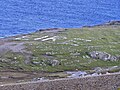
Malin Head ( Irish Cionn Mhálanna ) is the northernmost point on mainland Ireland and is located in County Donegal on the Inishowen peninsula . Ten kilometers north is the island of Inishtrahull .
In addition to the remains of a watchtower that was used as the British Admiralty Tower from 1805 to 1909 and served as a lookout tower for the Irish Defense Forces during the Second World War , you can marvel at the word ÉIRE, which was once made of stones and used during the Second World War should signal to opposing aircraft that they are now flying over neutral territory.
There is still a weather station on Malin Head , where wind force 12 is often measured - the highest wind speed measured here was 181.5 km / h on September 16, 1961, when Hurricane Debbie caused great damage to the Irish west coast. There is also a Navtex transmitting station at this weather station .
| Malin Head | ||||||||||||||||||||||||||||||||||||||||||||||||
|---|---|---|---|---|---|---|---|---|---|---|---|---|---|---|---|---|---|---|---|---|---|---|---|---|---|---|---|---|---|---|---|---|---|---|---|---|---|---|---|---|---|---|---|---|---|---|---|---|
| Climate diagram | ||||||||||||||||||||||||||||||||||||||||||||||||
| ||||||||||||||||||||||||||||||||||||||||||||||||
Malin Head


Coordinates: 55 ° 22 ′ 51 ″ N , 7 ° 22 ′ 12 ″ W.