
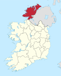
County Donegal
| map | |
|---|---|
  |
|
| Basic data | |
| Country: | Ireland |
| Administrative headquarters: | Lifford |
| Province: | Ulster |
| Irish name: | Tír Chonail |
| Surface: | 4860 km² |
| Residents: | 159,192 (2016) |
| License Plate: | DL |


Donegal [ ˌdɒnɪˈɡɔːl ] ( Irish Dhún na nGall [ ˈd̪ˠuːn̪ˠ n̪ˠə ˈŋaɫ ], about "fortress of the foreigners") is a county in the Republic of Ireland and is located in the Ulster region .
Surname
The name Tyrconnell (or Tyrconnel ), referring to a medieval kingdom in this area, is rarely used in English today. In Irish, however, this name ( Tír Chonail , mostly Tír Chonaill ( ˌtʲiːɾʲ ˈxɔnɔlʲ "Land of Conall")) is common, while Dún na nGall usually means the city of Donegal. The name in turn refers to an early medieval Viking castle. The terms "Donegal" and "Tyrconnell" are not exact synonyms, since the Inishowen peninsula belongs to Donegal, but traditionally not to Tyrconnell.
geography
The northernmost county of Ireland lies between the River Foyle and Donegal Bay or the Atlantic . The country consists mainly of the mountains of the Blue Stack Mountains , the Derry Veagh Mountains and the elevations on the Inishowen Peninsula . The highest point is Mount Errigal with a height of 752 m. The coast of Donegal is very rugged with bays and peninsulas. There are often miles of sandy beaches between cliffs up to 600 m high. Malin Head on the Inishowen Peninsula is the northernmost point of the Republic of Ireland.
Located in Donegal at Slieve League the falsely often called the highest cliffs cliffs of Europe designated Slieve League , while not as well known as the most visited Cliffs of Moher , due to their rugged beauty but are no less impressive.
history
Donegal was settled over 9,000 years ago. There are many archaeological sites for the subsequent period, such as dolmen tombs .
Christianity had great influence in Donegal early on and many of the early Christian monuments can be visited today, e.g. B. Churches and places dedicated to the memory of Saint Columcille , who is considered a convert to Scotland .
In the south of the county is Lough Derg , a well-known pilgrimage site in honor of St. Patrick . In the city of Donegal you can see the ruins of the Franciscan monastery of the same name from the 15th century and Donegal Castle.
Donegal, part of the Ulster region, as well as Cavan and Monaghan in the interior of the island have belonged to the Republic of Ireland , not Northern Ireland , since the division of Ireland in 1921 .
politics
The distribution of seats in Donegal County Council following the local elections on May 23, 2014:
| Political party | Seats |
|---|---|
| Fianna Fáil | 11 |
| Sinn Féin | 9 |
| Fine Gael | 6th |
| Labor Party | 1 |
| Non-party | 10 |
Donegal sends five MEPs to the Irish Parliament ( Dáil Éireann ); In the last election in 2016, Fianna Fáil won 2 seats and Fine Gael, Sinn Féin and an independent candidate one each.
economy
The vast grass pastures made the county one of the main sheep-raising areas in Ireland. In Killybegs the center of the Irish fishing industry is. Donegal is largely dependent on tourism income. With tourism came the economic boom, in the course of which many EU citizens finally immigrated here.
traffic
With Donegal Airport at Carrickfinn, the county has a regional airport, from which flybe serves Dublin and Glasgow .
The nearest train station is in Derry (Londonderry) in neighboring Northern Ireland.
tourism
Tourism is Donegal's main source of income, alongside sheep farming. Alternative tourism and club tourism can be found here as well as long-term tourism, which only makes up one eighth. Donegal is mainly geared towards short vacationers with many bed and breakfast options. After the strong industrialization in the rest of Ireland since 1990, attempts have been made in Donegal to preserve the traditional Ireland and to market it primarily for tourism.
Cities
- Ardara
- Ballybofey
- Ballyshannon
- Buncrana
- Bundoran
- Donegal
- Dunfanaghy
- Dungloe
- Falcarragh
- Glencolumbkille
- Glenties
- Gortahork
- Gweedore
- Kilcar
- Killybegs
- Letterkenny
- Lifford
- Milford
- Moville
- muff
- Port Salon
- Raphoe
- Stranorlar
Scenic sights
- Glenveagh National Park
- Donegal Bay and St. John's Point
- Inishowen Peninsula
- Malin Head - Ireland's northernmost point
- Cliffs of Slieve League
- Tramore Beach
- Mount Errigal
- Muckish Mountain
- Cruit Island
- crossed beach
Archaeological sites


- Ardmore menhir with cup-and-ring markings
- Ards Beg , Portal Tomb
- Ballymunterhiggin, Court Tomb
- Barnes Lower, standing stones with cup-and-ring markings
- Bavan Court tomb
- Beltany Tops, stone circle
- Carnaghan, portal tomb
- Cloghanmore also Malin More, Court tomb, Portal tombs,
- Croaghbeg , Court tomb
- Drumboghill, ( Doon Fort ) Fort and Crannóg
- Farranmacbride , Court tomb
- Glackadrumman, stone circle
- Gortnavern , portal tomb
- Grianán from Aileach Dun
- Kilclooney More 1 dolmen , portal tomb
- Wedge Tomb by Magheranaul
- Mevagh, petroglyphs
- Muntermellan's portal tomb
- Court Tomb by Shalwy
- Stroove basement
- Tawlaght, Court tomb
- Twomilestone, Menhir and Forts
Personalities
- Enya (* 1961), New Age musician, singer and songwriter
- Moya Brennan (* 1952), singer, harpist and songwriter
- Red Hugh O'Donnell
- Columcille (521 / 522–597), monk and missionary
- Isaac Butt (1813–1879), lawyer, economist and politician
- Derek Hill (* 1975), racing car driver
- Brian Friel (1929-2015), playwright
- Frank McGuinness (* 1953), playwright, poet and translator
- Daniel O'Donnell (born 1961), singer and television presenter
- Rory Gallagher (1948–1995), guitarist and singer-songwriter
- Shay Given (* 1976), soccer goalkeeper
- Pat Bonner (* 1960), soccer player
Web links
Individual evidence
- ^ Donegal (County) on citypopulation.de, accessed July 7, 2017
Carlow |
Cavan |
Clare |
Cork |
Cork (City) ** |
Donegal |
Dublin * |
Dublin (City) ** |
Dún Laoghaire-Rathdown ** |
Fingal ** |
Galway |
Galway (City) ** |
Kerry |
Kildare |
Kilkenny |
Laois |
Leitrim |
Limerick |
Longford |
Louth |
Mayo |
Meath |
Monaghan |
Offaly |
Roscommon |
Sligo |
South Dublin ** |
Tipperary |
Waterford |
Westmeath |
Wexford |
Wicklow
* historic county, ** newly created county
Coordinates: 54 ° 55 ′ N , 7 ° 52 ′ W