
Cliffs of Moher
Coordinates: 52 ° 56 ′ 10 ″ N , 9 ° 28 ′ 15 ″ W.


The Cliffs of Moher ( Irish Aillte an Mhothair ) are the most famous steep cliffs in Ireland . They are located on the southwest coast of Ireland's main island in County Clare near the villages of Doolin (north of the cliffs) and Liscannor (south of the cliffs).
The name
The ruins of a fortified residence of a chief, mostly overgrown by plants , are often called mothar (pronounced "moher") in the province of Munster , including in County Clare . The term originally referred to a group of trees or bushes. Such a stone fort once stood on the cliff near Hag's Head on the west coast of County Clare, called Moher O'Ruan (Irish Mothar Uí Ruain , "O'Ruan's crumbled fort"). This landmark gave the cliffs their name.
description
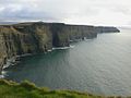
The cliffs protrude almost vertically from the Atlantic Ocean in many places and extend for more than eight kilometers. At the south end, the Hag's Head , they have a height of about 120 m, north of the O'Brien's Tower they even reach 214 m.
The O'Brien's Tower is about halfway along the shore and was built in 1835 as a watchtower on behalf of Sir Cornellius O'Brien . When the visibility is good, the Aran Islands and sometimes also Galway Bay can be seen from there. Beyond this are the Maumturk Mountains in Connemara .
Birds live almost exclusively on the cliff; a census showed 30,000 animals in 30 species. The most interesting are the Atlantic puffins , which live in large colonies in isolated spots on the cliff and on Goat Island . There are also hawks , seagulls , shags , guillemots and alke .
tourism
In summer, the cliffs are a very popular tourist attraction. The visitor center's paid parking lot near O'Brien's Tower is crowded with visitor vehicles and stalls. Admission is free for hikers and cyclists.
A broad path initially directs the stream of tourists up a hill to the cliffs to a viewing platform. There is also an unsecured path on the edge of the cliffs that continues to Hag's Head ( Ceann na Cailleach ). Until the middle of 2013, however, a cordon prevented anyone from continuing. A sign asked in English, French and German not to use the path. With the opening of the Cliffs Coastal Walk on June 14, 2013, a new path was created on the edge of the cliffs, based on the previously cordoned off. This made it possible to walk all of the cliffs on a stretch of almost 20 km between Doolin and Liscannor. This new path is mostly unpaved and partly in the form of a beaten path leads along the coastline just a few meters from the edge of the cliff.
On February 8, 2007, the visitor center with paved sidewalks was completed. The approximately 200 meter long part of the visitor path, which extends to O'Brien's Tower , was delimited at the side by stone slabs up to 1.40 meters high for safety reasons, so that visitors can no longer step directly up to the cliff. Since then, the view of the cliffs has been restricted. South of the cliffs is the rocky island of Bishop's Island .
The Cliffs of Moher are the most famous cliffs in Ireland, but not the highest. The Slieve League in County Donegal, Ireland , is 601 m high at its highest point and the cliffs of Croaghaun on Achill Island in County Mayo are as high as 664 m. The cliffs of Croaghaun are not developed for tourism and are therefore less popular.
Arts and Culture
The Cliffs of Moher are a popular filming location for movies . Scenes for Harry Potter and the Half-Blood Prince , Hear My Song and The Prince's Bride and Star Wars Episode 7 were created here .
photos

O'Brien's Tower , cliff height approx. 200 m

Looking north with O'Brien's Tower

Looking east
Facing south

View of Hag's Head in stormy weather

"Branaunmore" crag

Kittiwakes and Guillemots on Branaunmore

Sunset, February 2005
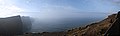
Panorama, December 2006

Cliffs of Moher in fantastic weather in June 2007

Cliffs of Moher, September 2016


.jpg)

