
County Dublin
| map | |
|---|---|

|
|
| Basic data | |
| Country: | Ireland |
| Administrative headquarters: | Dublin |
| Province: | Leinster |
| Irish name: | Áth Cliath |
| Surface: | 921 km² |
| Residents: | 1,270,603 (2011) |
| License Plate: | D. |
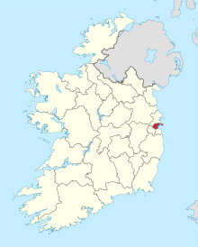
Dublin ( Irish Baile Átha Cliath ) was until 1994 a county ( county ) in the Republic of Ireland .

|

|
|
|
County Dublin coat of arms and flag
|
||
With effect from January 1, 1994 County Dublin was dissolved by law and the new Counties Fingal (seat: Swords ), Dún Laoghaire-Rathdown (seat: Dún Laoghaire ) and South Dublin (seat: Tallaght ) as well as the now independent city of Dublin divided up. However, this restructuring has only reached a limited extent in the public consciousness; the term "County Dublin" is still heard and read frequently.
economy
Agriculture consists mainly of cattle and sheep breeding. The city of Dublin is the country's economic center. Industry, trade, banking and insurance are concentrated here.
Cities
Attractions

- Ballyedmonduff Wedge Tomb
- Brenanstown
- Kilmashogue
- Portal Tomb by Kiltiernan
- Church of St Macuilin with a round tower from the 9th century in Lusk
Web links
Carlow |
Cavan |
Clare |
Cork |
Cork (City) ** |
Donegal |
Dublin * |
Dublin (City) ** |
Dún Laoghaire-Rathdown ** |
Fingal ** |
Galway |
Galway (City) ** |
Kerry |
Kildare |
Kilkenny |
Laois |
Leitrim |
Limerick |
Longford |
Louth |
Mayo |
Meath |
Monaghan |
Offaly |
Roscommon |
Sligo |
South Dublin ** |
Tipperary |
Waterford |
Westmeath |
Wexford |
Wicklow
* historic county, ** newly created county
Coordinates: 53 ° 23 ′ N , 6 ° 17 ′ W