
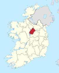
County Longford
| map | |
|---|---|
  |
|
| Basic data | |
| Country: | Ireland |
| Administrative headquarters: | Longford |
| Province: | Leinster |
| Irish name: | To Longfort |
| Surface: | 1,091 km² |
| Residents: | 40,810 (2016) |
| License Plate: | LD |
Longford ( Irish Longford ) is a county ( county ) in the Republic of Ireland .

|
.svg)
|
|
|
Longford coat of arms and flag
|
||
geography
Longford lies in the Central Irish Plain and is bounded to the west by the River Shannon , into which the rivers Camlin and Inny flow and which flows through Lough Ree to the south-west . In the northern part is Lough Gowna , which flows into the Erne .
There are some ridges with heights of less than 300 meters; the tallest of them is Carn Clonhugh with a height of 278 meters. About a fifth of the county's area is covered with moors .
history
The Corlea Trackway is an Iron Age boardwalk that crosses a moor near Kenagh . In the Middle Ages , Longford was part of the Kingdom of Meath . In 1569 the county was established.
economy
Agriculture consists mainly of cattle breeding and dairy farming . There is food and textile industries .
politics
The distribution of seats in the county council after the local elections on May 23, 2014:
| Political party | Seats |
|---|---|
| Fine Gael | 8th |
| Fianna Fáil | 7th |
| Non-party | 3 |
Longford, together with County Westmeath, forms a constituency that sends four members to the Irish Parliament ( Dáil Éireann ); in the last election in 2016, Fianna Fáil, Sinn Féin, Fine Gael and an independent candidate each won one seat.
Cities
Attractions
- The portal tomb of Aghnacliff on the west side of Lough Gowna
- Birrinagh's Tomb Portal is east of Lough Gowna
- Longford Cathedral
Personalities
- Padraic Colum (1881–1972), writer
- Marguerite Donlon (* 1966), dancer, choreographer and ballet director
- Maria Edgeworth (1767–1849), writer
- Henry Hughes Wilson (1864–1922), General in World War I.
Web links
- Longford County Council (English)
- Longford Nature Resort (English)
Carlow |
Cavan |
Clare |
Cork |
Cork (City) ** |
Donegal |
Dublin * |
Dublin (City) ** |
Dún Laoghaire-Rathdown ** |
Fingal ** |
Galway |
Galway (City) ** |
Kerry |
Kildare |
Kilkenny |
Laois |
Leitrim |
Limerick |
Longford |
Louth |
Mayo |
Meath |
Monaghan |
Offaly |
Roscommon |
Sligo |
South Dublin ** |
Tipperary |
Waterford |
Westmeath |
Wexford |
Wicklow
* historic county, ** newly created county