
Shannon (river)
|
Shannon An tSionainn |
||
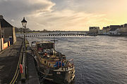
 The Shannon at Limerick; in the background King John's Castle |
||
| Data | ||
| location | Ireland , Europe | |
| River system | Shannon | |
| source |
Cuilcagh Mountains , County Cavan 54 ° 14 ′ 5 ″ N , 7 ° 55 ′ 9 ″ W |
|
| Source height | 76 m | |
| muzzle |
Atlantic Ocean near Limerick Coordinates: 52 ° 34 ′ 0 ″ N , 9 ° 42 ′ 0 ″ W 52 ° 34 ′ 0 ″ N , 9 ° 42 ′ 0 ″ W |
|
| Mouth height | 0 m | |
| Height difference | 76 m | |
| Bottom slope | 0.21 ‰ | |
| length | 370 km | |
| Left tributaries | Brosna , River Inny , River Feale | |
| Right tributaries | Suck | |
| Medium-sized cities | limerick | |
| Navigable | from the estuary to Leitrim | |
The Shannon ( Irish : An tSionainn , An tSionna ) is the longest and most water-rich river in Ireland and the British Isles at around 370 kilometers . Its catchment area covers around 15,700 square kilometers. Almost 250 kilometers of the river are navigable.
According to Celtic mythology, its origin and name go back to the female legendary figure Sionan .
course
The source of the Shannon is 76 m above sea level in the Cuilcagh Mountains in County Cavan in the north-west of the country. From here it first flows through an underground cave system and comes back to the surface as Shannon Pot . It drains the boggy center of Ireland and flows through lakes rich in fish. The largest of them are Lough Allen , Lough Ree, and Lough Derg . North of Limerick , the river forms rapids. To the west of Limerick, it flows through an approximately 100 km long estuary into the Atlantic . The estuary is heavily influenced by the tides .
Places on the river
![]() Map with all linked sites: OSM | WikiMap
Map with all linked sites: OSM | WikiMap

- Dowra
- Leitrim
- Carrick-on-Shannon
- Jamestown
- Drumsna
- Dromod
- Roosky
- Termonbarry
- Lanesborough – Ballyleague
- Athlone
- Clonmacnoise
- Shannonbridge
- Banagher
- Portumna
- Killaloe
- limerick
- Shannon
- Foynes
- Tarbert
- Kilrush
Waterway network
The Shannon is connected north of Carrick-on-Shannon by the revitalized Shannon-Erne Waterway (formerly Ballinamore & Ballyconnell Canal) with the lake area of Lough Erne in Northern Ireland. Downriver from Carrick-on-Shannon, the Jamestown Canal , built in 1848, bypasses a non-navigable part of the Shannon between Jamestown and Drumsna.
The Royal Canal branches off the Shannon north of Lough Ree and runs all the way to Dublin . Further south, the Grand Canal connects the Shannon with the River Barrow from Shannon Harbor (near Banagher ) and also leads to Dublin. A revitalization of the Ulster Canal is planned.

Shannon Pot, outlet of the Shannon in County Cavan

Bridge built in 1751 at Shannonbridge ; in the background the old fort
The Shannon in Athlone
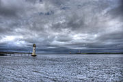
The Shannon estuary at Tarbert west of Limerick with the Tarbert Island Lighthouse

The River Shannon at Clonmacnoise
.jpg)

.jpg)
_(2).jpg)

Buildings and use
The Shannon has long formed the natural border between the eastern provinces and Connacht in the far west of the Irish island. During the Middle Ages , numerous castles were built on its banks.

Until the arrival of the railroad, the Shannon was the main route in the region. Ireland, which became independent after the First World War , invested extensively in the expansion of the river between 1924 and 1930 as part of the Shannon Power Development Project. To this day, the barrages of the Shannon with its power stations are Ireland's largest electricity supplier. Shannon International Airport is located near Limerick on the north bank of the river.
Today the Shannon is also important for tourism. Together with the great canals of Ireland, recreational skippers have a network of over 800 km of waterways at their disposal. The port of Kilrush at the mouth of the Shannon is home to the largest marina on the Irish west coast with 120 berths.
See also
Web links
- Information and maps on the Shannon (English)
Individual evidence
- ^ Meyers Neues Lexikon , Bibliographisches Institut Leipzig, 1964. Volume 7, p. 488
- ↑ Kilrush Marina , accessed July 15, 2018