Lough Erne
|
Lough Erne Loch Éirne |
||
|---|---|---|

|
||
| Geographical location |
|
|
| Tributaries | Erne (river) | |
| Drain | Erne (river) | |
| Places on the shore | Enniskillen , Belturbet , Belleek | |
| Data | ||
| Coordinates | 54 ° 29 ′ 0 ″ N , 7 ° 49 ′ 0 ″ W | |
|
|
||
| surface | 105 km² | |
| length | approx. 80 km | |
| width | up to 10 km | |
| Maximum depth | 64 m | |
| Middle deep | 6.5 m | |
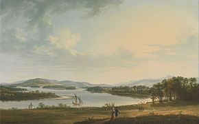
Lough Erne ( Irish Loch Éirne ) refers to two lakes in the river basin of the Erne , extending over a length of about 80 km , which mainly belong to the British Northern Ireland , to a lesser extent also to the Republic of Ireland . The lakes ( Upper Lough Erne and Lower Lough Erne ) are used extensively for fishing and boat tourism. The main town of the region is the town of Enniskillen on an island between the two lakes . Both parts of the lake are passable for boats; a lock operation is necessary depending on the water level ; the lock (Portora Lock) is located downstream of Enniskillen at the narrow point between the two lakes.
overview
There is lively houseboat tourism on both parts of the lake ; There is only a small amount of commercial shipping (excursions from the larger towns). The lakes can be navigated without a license after instruction by the boat rental company. The organization Waterways Ireland , which manages the cross-border inland waterways in the Republic of Ireland and Northern Ireland , is responsible for the management of the waterway and the navigation facilities - orientation is made difficult by the numerous islands and peninsulas . Marking with sea markers is based on a separate concept and not according to IALA .
Lough Erne has been connected to the upper Shannon near Leitrim since the reopening of the connecting canal (today SEW = Shannon-Erne-Waterways, formerly Ballinamore & Ballyconnell Canal) . Both lakes are said to have 154 islands together; However, the information in various sources varies widely.
Important sights in the vicinity of the lakes are:
- Crom Castle
- Galloon (old cemetery)
- Castle, museums; Cole Monument in Forthill Park in Enniskillen, Castle Coole near Enniskillen
- Devenish Island (monastery island with round tower , near Enniskillen)
- Boa Island with stone figures
- Tully Castle
- White Island (church ruins, sculptures)
- Castle Archdale
- Portora Castle (at the lock)
- View point above Magho Jetty
Lower Lough Erne (Loch Éirne Íochtair)
The northern part of the lake offers a large expanse of water. The islands include Boa Island, Cleenishmeen Island, Crevinishaughy Island, Cruninish Island, Devenish Island , Ely Island, Goat Island, Horse Island, Inish Davar, Inish Doney, Inish Fovar, Inish Lougher, Inish More, Inishmacsaint, Inishmakill, Lusty Beg Island , Lusty More Island and White Island .
Upper Lough Erne (Loch Éirne Uachtair)
The southern Upper Lake is much more rugged than the northern part of the lake; Because of the many islands and peninsulas, the boat trip often does not give the impression of being on a lake, but rather in a river and canal system. The islands in Upper Lake - some of which are privately owned - include Bleanish Island, Dernish Island, Inis Rath, Galloon Island, Inishcorkish, Inishcrevan, Inishfendra, Inishleague, Inishlught, Inishturk, Killygowan Island, Naan Island and Trannish.
Houseboat tourism
There are a number of houseboat rental companies. You can moor at all public jetties free of charge and stash water. Faecal disposal has not yet been fully introduced in 2015 (pump outs in Belleek, Round'O Enniskillen, Carrybridge, Galloon, Belturbet and at the landlords). All houseboats must have a holding tank. Northern Irish houseboat bases are at Lisnarick, Killadeas, Bellanaleck and Carrybridge; the base in Belturbet (Republic of Ireland) will be rebuilt in 2015 by the Aghinver Boat Company (charter from 2016).
Others
In the area of County Fermanagh (Northern Ireland) the pound sterling is used as currency . In addition to the Bank of England, some Northern Irish banks are also allowed to issue pound notes.
There is a tourist information center at the Lakeland Forum (Broadmeadows Jetty) across from the bus station. There are also fishing licenses there. It is recommended that you carefully study the details of fishing law in both countries.
Web links
Individual evidence
-
↑ see photo gallery atCommons : Boa Island - album with pictures, videos and audio files


