
Lough Derg (Shannon)
| Lough Derg | ||
|---|---|---|

|
||
| View over the southern part of Lough Derg | ||
| Geographical location | Midwest Ireland | |
| Tributaries | Shannon , Nenagh | |
| Drain | Shannon | |
| Islands | Holy Island with ruins from the 7th century | |
| Places on the shore | Portumna , Killaloe | |
| Data | ||
| Coordinates | 52 ° 57 ′ N , 8 ° 19 ′ W | |
|
||
| Altitude above sea level | 33.5 m | |
| surface | 118 km² | |
| volume | 0.887 km³ | |
| scope | 179 km | |
| Maximum depth | 36 m | |
| Middle deep | 7.6 m | |

The Lough Derg ( irish hole Deirgeirt "Red Lake") is a lake in the midwest of the island of Ireland. After Lough Neagh (in Northern Ireland) and Lough Corrib (in County Galway ) it is the third largest lake in Ireland .
description
Lough Derg is, along with Lough Allen and Lough Ree, one of the three lakes to which the Shannon widens in its course. Lough Derg is located in the lower reaches of the Shannon, southeast of the Slieve – Aughty Mountains and borders the counties of Galway , Clare and Tipperary .
Its maximum north-south extension is 35 km between Portumna in the north and Killaloe in the south. The largest width of 13 km measures the Lough with its southern foothills in the section of Scariff-Youghal-Bay. However, the average width is less than 5 km. The deepest point is at Parkers Point ; there a small ditch drops down to 36 m. There are extensive areas of shallow water in the north of the lake. In the reed-covered bays, it has an average water depth of 4 m.
The tributary of the Shannon is at Portumna, the outflow is at Killaloe. On the east bank, near the village of Dromineer , the River Nenagh flows into the lake.
There are a number of uninhabited islands in the lake. The largest island with 0.61 km² is called Illaunmore. The best known is Holy Island , Irish Inis Cealtra ; on it are the ruins of an abbey , from the 7th century , a porthole and a round tower .
A lake of the same name is located in County Donegal near the border with Northern Ireland .
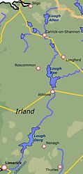
Location of the three great Shannon lakes
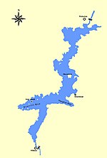
Lough Derg Map


Web links
- Lake Derg (Lough Derg) at the International Lake Environment Committee (English)
- Shannon information on shannon-info.de
- Photos from Killaloe / Ballina on irland-photos.com
- Panorama picture from Lough Derg on klamonfra.de