Lough Derg (Donegal)
| Lough Derg | ||
|---|---|---|

|
||
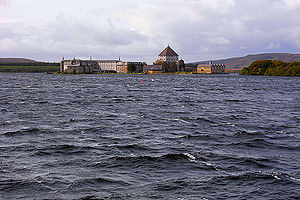
| View of Station Island in Lough Derg | ||
| Geographical location | County Donegal , Ireland | |
| Drain | River Derg → River Morne → River Foyle | |
| Location close to the shore | Pettigo | |
| Data | ||
| Coordinates | 54 ° 36 '50 " N , 7 ° 52' 20" W | |
|
|
||
| Altitude above sea level | 143 m ASL | |
| surface | 8.88 km² | |
The Lough Derg ( Irish Loch Dearg , dt. "Red Lake") is a lake in the Irish County Donegal in the province of Ulster , near the border with Northern Ireland . There are other lakes with this name on the island.

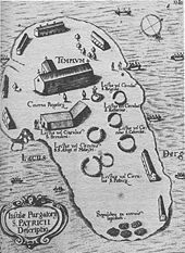
Saint Patrick's Purgatory on a map from 1666
geography
The lake with an area of about 888 hectares is located around six kilometers north of the border village of Pettigo .
Place of pilgrimage
There are several islands in Lough Derg; there was a monastery on Saints Island ( Oileán na Naomh ) in the Middle Ages . On Station Island ( Inis an Turais ), there is the Purgatory of St. Patrick , an old pilgrimage site that attracts around 35,000 pilgrims annually.
Bird sanctuary
The lake is a designated bird sanctuary .
A lake of the same name is located in the Shannon .
Individual evidence
- ↑ John Cunningham: Lough Derg: the spirit of a holy place. catholicireland.net, 1997, archived from the original on July 16, 2011 ; accessed on June 21, 2016 .
- ^ Lough Derg (Donegal) BirdWatch Ireland , accessed June 21, 2016.
Web links
Commons : Lough Derg, County Donegal - Collection of pictures, videos and audio files

