
Muckish Mountain
| Muckish to Mhucais | ||
|---|---|---|
 Muckish Mountain from the north |
||
| height | 666 m ASL | |
| location | Donegal , Ulster , Ireland | |
| Mountains | Derryveagh Mountains | |
| Coordinates | 55 ° 6 '22 " N , 7 ° 59' 45" W | |
|
||
| Type | Table Mountain | |
| rock | Quartzite | |

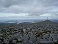
The Muckish Mountain ( Irish : An Mhucais , means: 'pig back') is the northernmost mountain of the Derryveagh Mountains . At its summit there is a cairn that can be seen from afar . The entire summit region consists of a large scree area, the lowest point of which is around 630 m and the highest point at 666 m . From its northern tip you have a wide all-round view of the entire north coast of Donegal. From the south side one overlooks the Derryveagh Mountains with Mount Errigal .
Quartz sand used to be mined on its flanks. The northern ascent route is on the Miner's Path through an old quarry. The ascent from Muckish Gap in the south is a little easier.
Because of its rare alpine and boreal vegetation, the mountain is to be declared a nature reserve under the EU Habitats Directive . [obsolete] The black crowberry ( Empetrum nigrum ) and the bilberry ( Vaccinium myrtillus ) in the summit area and on the slopes classified as silicate rocks with crevice vegetation (8220) various mosses ( Bryophyta ), common alpine colt ( Saussurea alpina ) and white silver arum ( Dryas octopetala ). Several breeding pairs of the peregrine falcon ( Falco peregrinus ) have been observed on the mountain .
photos
the northern peak

View of the Aghlas and behind it Mt. Errigal


Web links
- Muckish Mountain SAC 001179. National Parks & Wildlife Service, accessed November 12, 2014 .
credentials
- ↑ Muckish Mountain cSAC Site Code 1179. (PDF) In: National Parks and Wildlife Service Conservation Plan for 2005-2010. Dept. of Environment, Heritage and Local Government, July 2005, accessed November 12, 2014 .