Regional color
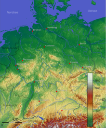
Regional colors are the color areas on wall and atlas maps that divide an area into individual height regions. For example, green stands for lowlands, light brown for hills or mountains, brown for low mountain ranges and dark brown and white for high mountains. This also includes the depths of the sea. In school cartography, regional colors are part of the physical map . The colors for the height areas ( color hypsometry ) in Germany today mostly follow the so-called conventional color scale, which is closely related to the spectral color scale.
Coloring
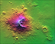
Different heights are symbolized by different colors. Color scales whose colors correspond to the natural cover or the color perception from the air are common. A very common scale goes from green (like grass) in the lowlands to yellow, brown (crippled wood), gray (rock) to white (snow), corresponding to the following heights:
- 0-100 m: blue-green
- 100–200 m: yellow-green
- 200–500 m: yellow
- 500–1000 m: light brown
- 1000–2000 m: brown
- 2000-4000 m: red-brown
- 4000-5000 m: brown-red
- Summit areas: white
A shading supports depth.
history
Beginnings
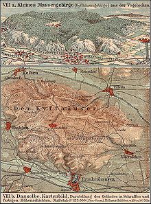
The first to use Theodor Freiherr von Liechtenstern in 1836 and Emil von Sydow two years later regional colors for use in schools in the new map type to the so-called physical mountain and water card contained a that no political boundaries and few places orientation. At first there was only one color - brown or green - and a color-free white area to illustrate the low and highlands. The centerpiece of the maps was the representation of the relief using the highly developed hatching technique . The mountain hatches in black or brown without any additional color overprint indicated the mountain regions. It was initially the task of the regional color to emphasize it; it did not yet represent a defined level of elevation. "The lowlands should ... stand out as the basis of the elevations in contrast to them," said Sydow, and green seemed to him "appropriate when it was best compared to the brown of the mountains (in hatching)." Lowland brown remained in use in the 19th century . In the end, Sydow's lowland green, commonly identified with the natural color of meadow green, was not accepted, although it was not Sydow's “idea” to “express the relationships of living nature through the color.” Later, three to four height levels were introduced with fixed delimitations by the lowland color was subdivided by means of a fine, sometimes wider, sometimes narrower grid of lines. The use of the two regional colors green and brown on a map in the hatching manner was the exception.
Elevation layers
In addition, there was the relief display along narrower layers of elevation in different colors without hatching. The Austrian Franz Ritter v. Hauslab developed a systematic color and height scale for up to seven layers of height around 1830 , which arranged the colors in the manner of a step ladder according to the principle “the higher, the darker”. In Germany, the first full-color printed physical maps with four to seven elevation layers appeared after the middle of the 19th century. Based on the regional colors, lighter and more saturated beige-brown tones were placed between the corner colors green and dark brown. The more colorful house labs did not catch on. The height layers cards remained without mountain strokes limited to the century of their creation.
breakthrough

It was not until the 1880s that the physical map with the regional colors became the basic map of the school atlases. Until then, the political cards dominated. The school atlas by Carl Diercke and Eduard Gaebler from 1883 marked this turning point. Color-free areas disappeared, uniform height and color scales for height layers became common and the hatched mountain regions were also given a surface color. Inspired by the Austrian Karl Peucker , after the turn of the century the spectral color scale, especially the colors yellow and red, and the color perception from the aerial perspective flowed into the more three-dimensional color series. The regional colors, extended by the color yellow, became richer and more contrasting. Peucker's own scale and color series developed according to it with red as the color for the highest mountain layer, as used in the wall maps by Hermann Haack , were not widely used in German cartography . In the end, an agreement was reached on a version of the spectral color scale that had already been shaped by tradition. Today, in addition to the traditional physical map, a second “physical” - natural spatial - map has appeared, which makes the land cover or vegetation recognizable by means of surface colors. The classic physical map and with it the regional colors will continue to be of importance as a guide and orientation map.
literature
- Karl Peucker: Shadow sculpture and color sculpture: Contributions to the history and theory of terrain representation. Artaria Publishing House, 1898
- Johannes Dörflinger, Ingrid Kretschmer, Franz Wawrik, E. Tomasi: Lexicon for the history of cartography. Verlag F. Deuticke, 1986, ISBN 3-7005-4562-2
- Jürgen Espenhorst: Petermann's Planet. A Guide to German Handatlases and their Siblings throughout the World 1800–1950. 2 vol., Schwerte 2003/08
- Ingrid Kretschmer, Erik Arnberger: Lexicon for the history of cartography. Vienna 1986
- Ingrid Kretschmer: Colors close to nature versus color hypsometry. In: Cartographica Helvetica , Heft 21 (2000), pp. 39-48 full text
- Verena Kleinschmidt: In the beginning there was “Liechtenstein / Lange”. From the early history of Westermann cartography. In: Geographische Rundschau , issue 5/2004
- Jürgen Bollmann, Wolf Günther Koch: Lexicon of cartography and geomatics in two volumes. Berlin, Heidelberg 2001/02
- Wolfgang Tietze: Westermann Lexicon of Geography. Braunschweig 1968
Individual evidence
- ↑ http://www.diercke.de/kartenansicht.xtp?artId=978-3-14-100770-1&stichwort=Schummerung&fs=1
- ↑ Günter Hake, Dietmar Grünreich, Liqiu Meng: Cartography: visualization of spatial and temporal information . Walter de Gruyter, 2002, ISBN 3-11-016404-3 , p. 433 (604 p., Limited preview in Google Book search).

