District of Passau
| coat of arms | Germany map |
|---|---|

|
Coordinates: 48 ° 34 ' N , 13 ° 22' E |
| Basic data | |
| State : | Bavaria |
| Administrative region : | Lower Bavaria |
| Administrative headquarters : | Passau |
| Area : | 1,530.29 km 2 |
| Residents: | 192,656 (Dec. 31, 2019) |
| Population density : | 126 inhabitants per km 2 |
| License plate : | PA |
| Circle key : | 09 2 75 |
| NUTS : | DE228 |
| Circle structure: | 38 parishes |
| Address of the district administration: |
Domplatz 11 94032 Passau |
| Website : | |
| District Administrator : | Raimund Kneidinger ( CSU ) |
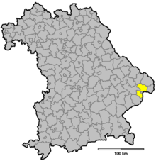
| Location of the district of Passau in Bavaria | |
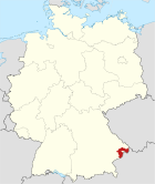
The district of Passau is located in the Bavarian administrative district of Niederbayern . The independent city of Passau extends from the east like a wedge into the district area, so that the district extends in a semicircle around this city. In terms of area, it ranks third in the districts in Bavaria and fifth in terms of population. In the east and south it borders on Upper Austria.
geography
location
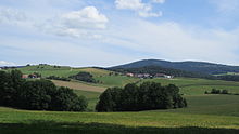
The Danube flows through the district from northwest to southeast . In the east of the district this forms the border with Austria ( Upper Austria ). The Danube divides the district into two different landscapes. In the north, the foothills of the Bavarian Forest stretch up to heights of almost 1,000 m. The Ilz , a left tributary of the Danube, which flows into Passau, flows on the edge of the Bavarian Forest . A hilly landscape extends south of the Danube and extends to the Rottal . The Rott is a left tributary of the Inn , runs through the southern district from west to east and flows into Neuhaus am Inn . In the west of the district the Vils flows for a few kilometers before it flows into the Danube in Vilshofen .
Neighboring areas
The district borders in a clockwise direction in the west on the districts of Rottal-Inn , Deggendorf and Freyung-Grafenau , of which it is the largest. In the east and south it borders on the Austrian state of Upper Austria .
history
Regional courts
Before 1800, the area of today's Passau district belonged mainly to the Passau bishopric and became part of Bavaria in 1806. Then the regional courts of Passau and Wegscheid were established. The district courts of Griesbach im Rottal and Vilshofen were established as early as 1803 . In 1809, the city of Passau became a city in the immediate vicinity of a district . Like all regional courts, this belonged to the Lower Danube District , which was renamed Lower Bavaria in 1838 . At the same time, the Passau Regional Court was divided into the Passau I and Passau II regional courts, the Rotthalmünster regional court separated from the Griesbach regional court and the Osterhofen regional court separated from the Vilshofen regional court. There were also changes at the Wegscheid Regional Court.
District Offices
The District Office of Passau was formed in 1862 through the merger of the older district courts Passau I (for the communities on the left of the Danube) and Passau II (for the communities on the right of the Danube). Likewise, the district courts of Griesbach im Rottal and Rotthalmünster were merged to form the district office of Griesbach im Rotthal and the district courts of Osterhofen and Vilshofen to form the district office of Vilshofen, while the district office of Wegscheid followed the district court of Wegscheid.
On June 4, 1870, the Passau District Office ceded the municipality of Sankt Nikola to the City of Passau.
On the occasion of the reform of the layout of the Bavarian district offices, the Passau district office received the Wegscheid district office on January 1, 1880 when the municipality of Eging was ceded to the Vilshofen district office. In 1888, the Wegscheid district office was reestablished by hiving off its former communities from the Passau district office.
On January 1, 1909, the district office ceded the Haidenhof community to the city of Passau. On July 1, 1923, the Beiderwies community was added.
Counties
On January 1, 1939, the designation district was introduced as everywhere else in the German Reich . The district offices became the districts of Griesbach im Rottal, Passau, Vilshofen and Wegscheid.
District of Passau
As part of the regional reform in Bavaria , today's district of Passau was established with effect from July 1, 1972. It was made up of
- the old district of Passau except for the so-called suburbs Heining , Hacklberg , Hals and Grubweg , which were incorporated into the independent city of Passau
- the dissolved district of Wegscheid
- the dissolved district of Griesbach im Rottal except for the communities of Bayerbach , Birnbach and Kindlbach
- the city of Vilshofen and the communities of Aidenbach , Albersdorf, Aldersbach , Alkofen , Aunkirchen , Beutelsbach , Eging , Garham, Haidenburg , Hofkirchen , Kirchberg , Königbach, Ortenburg , Otterskirchen , Pleinting , Rathsmannsdorf , Walchsing , Windorf , Wolfachau and Zeitlarn from the dissolved district of Vilshofen such as
- the municipality of Pörndorf from the dissolved district of Eggenfelden .
Passau remained the seat of the enlarged district. Plans to incorporate the municipalities or parts of the municipalities of Salzweg (with the exception of Straßkirchen), Neuburg am Inn, Neukirchen am Inn and Fürstenzell into the urban area were rejected.
Population development
From 1988 to 2008, the Passau district grew by around 24,000 inhabitants or around 15%. From 2006 the trend was downward. Between 1988 and 2018 the district grew from 163,999 to 192,043 by 28,044 inhabitants or by 17.1%. The municipality of Bad Füssing and the city of Pocking in the south of the district had the highest percentage growth, and the lowest was mostly in the municipalities in the Bavarian Forest near the border. The following figures refer to the territorial status on May 25, 1987.
| Population development | |||||||||||||||
|---|---|---|---|---|---|---|---|---|---|---|---|---|---|---|---|
| year | 1840 | 1900 | 1939 | 1950 | 1961 | 1970 | 1987 | 1991 | 1995 | 2000 | 2005 | 2010 | 2015 | ||
| Residents | 88,842 | 104,735 | 113,957 | 160,967 | 140.038 | 149.086 | 162,355 | 173.713 | 182.041 | 186.509 | 189,142 | 187,347 | 188,336 | ||
Politics and administration
District council
The district council consists of 70 district councilors and the district administrator. After the district council election on March 15, 2020 , the district councils will be divided between the following parties:
| Political party | Seats |
|---|---|
| CSU | 26th |
| SPD | 7th |
| FWG | 9 |
| GREEN | 6th |
| FDP | 1 |
| ÖDP | 5 |
| AfD | 6th |
| ÜW | 6th |
| BU | 4th |
District Administrator

Franz Meyer ( CSU ), who replaced the long-time District Administrator Hanns Dorfner , has been the District Administrator of the Passau district since the 2008 local elections . With 66.7% of the vote, he won ahead of Jella Teuchner ( SPD ), who received 12% of the votes, and Marieluise Erhard ( Free Voters ). In the municipal elections in Bavaria in 2014 , Franz Meyer was confirmed in office with 71.2% of the votes. In the 2020 district election, he was replaced by Raimund Kneidinger (CSU), the joint candidate of the CSU and the Citizens' Union, who received 56.21% of the valid votes.
- District administrators since 1972
| 1972-1990 | Baptist Kitzlinger (CSU) has been the district administrator of the old district of Passau since 1970 |
| 1990-2008 | Hanns Dorfner (CSU) |
| 2008-2020 | Franz Meyer (CSU) |
| since May 1, 2020 | Raimund Kneidinger (CSU / BU) |
coat of arms
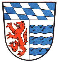
| Blazon : "Above a silver-blue roughened shield base in silver, a rising red wolf in the front, a red panther rising away from it." | |
| Reasons for the coat of arms: The coat of arms symbolizes the merger of the former districts of Wegscheid, Vilshofen and Griesbach. The red wolf is reminiscent of the old bishopric of Passau , which is now the central area of the district. The red panther stands for the area that used to belong to Vilshofen and Griesbach. The rhombuses symbolize the Bavarian authority organization that applies throughout Bavaria. |
administration
The district administration of the district is formed by the District Office Passau with its headquarters on Domplatz in the urban area of the independent city of Passau. In addition to the main office on Domplatz, there are other offices in Passau Auerbach, Fürstenzell, Patriching and Salzweg. Vehicle registration offices are located in other buildings in Salzweg, Bad Griesbach, Hauzenberg, Pocking, Vilshofen ad Donau and Wegscheid.
religion
The majority of the district is Catholic. Historically, only the community of Ortenburg is evangelical. A total of 84% of the population are Roman Catholic and 8.1% Protestant.
Economy and Infrastructure
In the Future Atlas 2016 , the district of Passau was ranked 245 out of 402 districts, municipal associations and urban districts in Germany, making it one of the regions with a “balanced risk-opportunity mix” for the future.
Around half of the around 48,000 employees who are subject to social security contributions work in companies in the secondary sector, i.e. in the manufacturing sector, such as industry and craft. Overall, the most important sectors are the service industry, mechanical engineering and vehicle construction, construction, electrical engineering, optics and the printing and food industry. The extraction of raw materials also plays a certain role: Germany's only graphite deposit and mine is located in Kropfmühl ; there Hauzenberger graphite is extracted. Granite has been mined in Neustift near Ortenburg for several decades. In addition, wood processing makes an economic contribution to the district.
The international MEGAL natural gas pipeline runs in the north of the district . This pipeline started operating in 1980. A compressor station of the pipeline is located in Wildenranna .
education
In the district there are 65 secondary schools and primary schools with 713 teachers and 9,902 students (number of students as of the 2013/14 school year):
- High schools in Fürstenzell ( Maristengymnasium ), Pocking, Untergriesbach and Vilshofen ( Gymnasium Vilshofen ) with a total of 240 teachers and 3,173 students
- Secondary schools in Bad Griesbach, Hauzenberg, Neuhaus am Inn, Neustift (near Ortenburg), Ortenburg, Tittling and Vilshofen with a total of 234 teachers and 3,805 students
- Eight vocational schools with a total of 84 teachers and 1,462 students
- Four special schools: one in Hauzenberg, two in Pocking and one in Vilshofen with a total of 97 teachers and 524 students
- A technical college in Passau Auerbach
In addition, many students take advantage of the educational offers in the neighboring city of Passau, as well as the further educational offers in the neighboring districts.
traffic
Road traffic
The main axes of traffic in the Passau district are the highways and federal highways that converge in Passau. The most important connection is the A3 autobahn coming from Regensburg, which crosses the district from northwest to southeast and at the Suben border crossing merges into the Austrian Innkreis autobahn A 8 to Linz. Bundesstraße 8 runs parallel to this motorway . The federal highway 12 crosses the district in a north-south direction . This has a connection to the Czech expressway 4 in the north and connects Passau with Munich in its south branch. An extension to the A 94 motorway is planned for this branch . In addition to these roads, the federal highway 85 connects Passau with the larger cities of the Bavarian Forest such as Grafenau, Regen and Cham. In total there are 34 km of autobahns, 122 km of federal highways and 4229 km of other roads in the district (as of December 31, 2007).
Railway and local public transport
An important traffic axis in the district is the main railway line Nuremberg - Passau - Linz , which is used every hour by regional trains and every two hours by long-distance trains and freight trains. The Vilshofen (Niederbay) train station is the only remaining one in the district on this route . In addition to this main line, there is also a branch line in the direction of Rottal , which is served every hour. There are seven stops on this route in the district as well as the Pocking train station. In addition to these two lines used by passenger traffic, the Vilshofen – Ortenburg railway line has a freight connection. The Ilztalbahn has been in operation again in leisure traffic since 2011. Similar reactivation efforts are being made on the Passau – Hauzenberg railway line . In addition to these lines, there were the Kalteneck – Hengersberg and Vilshofen – Aidenbach lines . These have been dismantled and converted into railway cycle paths .
All train and bus connections within the Passau district are integrated in the Passau district transport association tariff .
Airport
In addition to several sports airports, there is also a commercial airport in Vilshofen an der Donau .
shipping
By the fall of the Iron Curtain and the construction of the Main-Danube Canal to the county migrating was Danube to an increasingly important international waterway.
Vehicle inventory
| Vehicle-
art |
Stock to | ||
|---|---|---|---|
| January 1, 2012 | January 1, 2013 | 1st of January 2014 | |
| Car | 110,632 | 111,954 | 113,546 |
| BIKE | 13,953 | 14,468 | 14,938 |
| Omnibuses | 301 | 295 | 309 |
| truck | 5,858 | 6,052 | 6.219 |
| Tractors | 16,368 | 16,617 | 16,849 |
| pendant | 24,573 | 25,375 | 26,144 |
Healthcare
The district operates a total of four hospitals in Rotthalmünster, Vilshofen ad Donau, Wegscheid and Bad Füssing with its district Passau Krankenhaus gGmbH, whose sole shareholder is the district of Passau. There is also a medical care center in Hauzenberg with a branch in Fürstenzell. Other facilities are the geriatric rehabilitation center in Aidenbach and a special facility for coma patients in Obernzell.
Communities
(Residents on December 31, 2019)
|
Other communities
|
|
The district of Passau before the regional reform in 1972
The Altlandkreis Passau was divided into 39 communities. Geographically, as it is today, it encompassed the urban district of Passau , in which the District Office was also located at that time . Through the city of Passau and the district of Vilshofen , the old district was divided into a smaller part south of the Danube around the Neuburg Forest and a larger part north of the Danube in the Bavarian Forest . The district was enclosed by the districts of Griesbach im Rottal , Vilshofen , Grafenau , Wolfstein and Wegscheid (clockwise). On the Upper Austrian side, the district bordered on the Schärding district .
coat of arms
Blazon : “Split under the silver-blue roughened shield head, a rising red wolf in front in silver, three blue wavy bars in silver behind .” - The old district coat of arms was approved in 1968.
Declaration of coat of arms: The Bavarian diamonds (heraldic silver-blue or white-blue) in the head of the shield symbolized belonging to Bavaria. The Passau wolf on the heraldic right side stood for the city of Passau and the affiliation to the old bishopric of Passau , especially the northern parts of the district. The three wavy bars on the heraldic left side signified the three rivers Danube , Inn and Ilz , which flow through the area of the old district.
Parishes before 1972
Before the beginning of the Bavarian territorial reform, the district of Passau comprised 39 communities in the 1960s:
| Name of the parish | Inhabitants 1933 | 1962 residents | Today's church |
|---|---|---|---|
| Aicha in front of the forest | 1325 | 1435 | Aicha in front of the forest |
| Altenmarkt | 913 | 1056 | Fürstenzell |
| Bad Höhenstadt | 826 | 1008 | Fürstenzell |
| Büchlberg | 1936 | 2071 | Büchlberg |
| Donauwetzdorf | 529 | 331 | Thyrnau |
| Dorfbach | 759 | 723 | Ortenburg |
| Eglsee | 633 | 589 | Ruhstorf on the Rott |
| Eholfing | 287 | 250 | Ruhstorf on the Rott |
| Engertsham | 906 | 968 | Fürstenzell |
| Fürstenstein | 2614 | 3503 | Fürstenstein |
| Fürstenzell | 1787 | 3146 | Fürstenzell |
| Grubweg | 1229 | 4544 | Passau |
| Hacklberg | 2603 | 4263 | Passau |
| Neck , market | 1251 | 1664 | Passau |
| Haselbach | 781 | 1001 | Tiefenbach |
| Heining | 2504 | 5232 | Passau |
| Hutthurm , market | 981 | 1966 | Hutthurm |
| Kellberg | 1024 | 1380 | Thyrnau |
| Munich | 771 | 1033 | Hutthurm |
| Neuburg am Inn | 816 | 1073 | Neuburg am Inn |
| Neuhaus am Inn | 932 | 1314 | Neuhaus am Inn |
| Neukirchen am Inn | 1294 | 1449 | Neuburg am Inn |
| Neukirchen in front of the forest | 1294 | 1869 | Neukirchen in front of the forest |
| Nirsching | 512 | 522 | Büchlberg |
| Oberdiendorf | 390 | 789 | Hauzenberg |
| Prague | 1014 | 1207 | Hutthurm |
| Rassberg | 530 | 630 | Hauzenberg |
| Rowing | 1001 | 1554 | Rowing |
| Salzweg | 867 | 1451 | Salzweg |
| Sandbach | 1086 | 1202 | Vilshofen |
| Straßkirchen | 828 | 961 | Salzweg |
| Sulzbach am Inn | 391 | 563 | Ruhstorf on the Rott |
| Thyrnau | 937 | 1351 | Thyrnau |
| Tiefenbach | 1212 | 1916 | Tiefenbach |
| Tittling , market | 2521 | 3539 | Tittling |
| Voglarn | 456 | 403 | Fürstenzell |
| Vornbach | 644 | 696 | Neuhaus am Inn |
| Witzmannsberg | 1331 | 1297 | Witzmannsberg |
| Wotzdorf | 1262 | 2003 | Hauzenberg |
Even before 1972, there were several changes to the structure of the district. In 1855 the parish of St. Nikola was divided. The eastern part came to the city of Passau in 1870 , the western part remained an independent municipality under the name Haidenhof until 1909 and was then also incorporated into Passau. In 1922 the Ries municipality was incorporated into the Hals municipality . In 1923 the municipality of Beiderwies was incorporated into Passau and has been part of the Innstadt district ever since . After the city of Passau bought the Veste Oberhaus in 1932, which at that time was in the municipality of Hacklberg , the fortress area was incorporated into Passau in 1938 together with the district of Bschütt.
District administrators until 1972
| from 1862 | Simon diver | District Administrator |
| from 1872 | Michael Fischer | District Administrator |
| from 1881 | Leopold Payer | District Administrator |
| until 1908 | Reinhard Wieland | District Administrator |
| 1908-1920 | Georg Hochgraßl | District Administrator |
| 1920-1930 | Ludwig Geist | District mayor |
| 1930-1933 | Michael Freudenberger | District mayor |
| 1933-1942 | Josef Endress | District Administrator |
| 1942-1945 | Friedrich Zagl | District Administrator |
| 1945 (May / June) | Leonhard Reitberger | acting district administrator |
| 1945 (July / August) | Frederick of Moreau | acting district administrator |
| 1945-1946 | Robert Prudlo | District Administrator |
| 1946 (May - August) | Heinz Wagner | District Administrator |
| 1946 (August - November) | Rudolf Beer | District Administrator |
| 1946-1964 | Hans Karl | District Administrator |
| 1964 | Adolf Oswald | acting district administrator |
| 1964-1970 | Fritz Gerstl | District Administrator |
| 1970-1972 | Baptist Kitzlinger | District Administrator (until 1990 also District Administrator of the new district) |
Protected areas
There are seven nature reserves , twelve landscape protection areas , 16 FFH areas and at least 41 geotopes designated by the Bavarian State Office for the Environment (as of August 2016) in the district.
See also
- List of nature reserves in the Passau district
- List of landscape protection areas in the district of Passau
- List of FFH areas in the Passau district
- List of geotopes in the Passau district
License Plate
On July 1, 1956, the district was assigned the distinctive sign PA when the vehicle registration number that is still valid today was introduced . It is issued consistently to this day, with the code of the district of Passau again exclusively with two letters (AA – ZZ 1–999), those of the independent city of Passau with only one letter (A – Z 1–9999) after the in both cases the preceding PA .
Until the 1990s, vehicles from the old districts received special identification numbers:
| area | Letters | numbers |
|---|---|---|
| Altkreis Passau | AA to SZ | 1 to 999 |
| Vilshofen old district | TA to VZ | |
| Altkreis Wegscheid | WA to WZ | |
| Altkreis Griesbach im Rottal | XA to ZZ |
Web links
- Official website of the district
- Literature from and about the district of Passau in the catalog of the German National Library
- Entry on the coat of arms of the district of Passau in the database of the House of Bavarian History
Individual evidence
- ↑ "Data 2" sheet, Statistical Report A1200C 202041 Population of the municipalities, districts and administrative districts 1st quarter 2020 (population based on the 2011 census) ( help ).
- ^ Wilhelm Volkert (ed.): Handbook of Bavarian offices, communities and courts 1799–1980 . CH Beck, Munich 1983, ISBN 3-406-09669-7 , p. 547 .
- ^ Wilhelm Volkert (ed.): Handbook of Bavarian offices, communities and courts 1799–1980 . CH Beck, Munich 1983, ISBN 3-406-09669-7 , p. 97 .
- ^ Ordinance on the reorganization of Bavaria into rural districts and independent cities of December 27, 1971
- ↑ Chronicle of the district of Passau ( Memento of the original from January 9, 2015 in the Internet Archive ) Info: The archive link was inserted automatically and has not yet been checked. Please check the original and archive link according to the instructions and then remove this notice.
- ↑ a b c District of Passau: Announcement of the final result of the election of the district council on March 15, 2020
- ↑ Two new district administrators in Lower Bavaria. March 15, 2020, accessed August 4, 2020 .
- ↑ Election of the District Administrator - 2020 municipal elections in the Passau district - overall result. Retrieved August 4, 2020 .
- ↑ Entry on the coat of arms of the district of Passau in the database of the House of Bavarian History , accessed on September 5, 2017 .
- ↑ Future Atlas 2016. (No longer available online.) Archived from the original on October 2, 2017 ; accessed on March 23, 2018 . Info: The archive link was inserted automatically and has not yet been checked. Please check the original and archive link according to the instructions and then remove this notice.
- ↑ - ( Memento of the original from May 8, 2014 in the Internet Archive ) Info: The archive link was inserted automatically and has not yet been checked. Please check the original and archive link according to the instructions and then remove this notice.
- ↑ Siegbert Müller, Enem new media agency, http://www.en-em.de/ : Passau GmbH Hospital: promote life - health as a job. (No longer available online.) In: lkr-pa-kh.de. Archived from the original on June 4, 2016 ; accessed on June 4, 2016 . Info: The archive link was inserted automatically and has not yet been checked. Please check the original and archive link according to the instructions and then remove this notice.
- ↑ "Data 2" sheet, Statistical Report A1200C 202041 Population of the municipalities, districts and administrative districts 1st quarter 2020 (population based on the 2011 census) ( help ).
- ^ Official register of places for Bavaria 1964
- ↑ The municipality of Büchlberg was called Leoprechting until April 14, 1950


