Haarbach
| coat of arms | Germany map | |
|---|---|---|

|
Coordinates: 48 ° 30 ' N , 13 ° 9' E |
|
| Basic data | ||
| State : | Bavaria | |
| Administrative region : | Lower Bavaria | |
| County : | Passau | |
| Height : | 380 m above sea level NHN | |
| Area : | 47.71 km 2 | |
| Residents: | 2574 (Dec. 31, 2019) | |
| Population density : | 54 inhabitants per km 2 | |
| Postcodes : | 94542, 94501 | |
| Primaries : | 08535, 08542 | |
| License plate : | PA | |
| Community key : | 09 2 75 125 | |
| Community structure: | 64 districts | |
| Address of the municipal administration: |
Main street 11 94542 Haarbach |
|
| Website : | ||
| Mayor : | Franz Gerleigner ( CSU ) | |
| Location of the community of Haarbach in the district of Passau | ||
Haarbach is a municipality in the Lower Bavarian district of Passau .
geography
Geographical location
The place Haarbach is located in the Danube Forest region around 28 km west of Passau , 18 km north of Rotthalmünster , 20 km east of Pfarrkirchen and 17 km south of Vilshofen an der Donau . This means that the municipality is on the edge of the Bavarian Tuscany (Lower Rottal), in the middle of the Klosterwinkel and the Holzland in the typical Lower Bavarian hilly landscape.
Neighboring communities
The neighboring communities are:
- Bad Griesbach in the Rottal
- Bad Birnbach ( Rottal-Inn district )
- Egglham ( Rottal-Inn district )
- Beutelsbach
- Ortenburg
Community structure
There are 64 parish parts:
There are the districts of Haarbach, Sachsenham, Uttlau and Rainding.
history
Until the church is planted
Haarbach was first mentioned in a document in 820, in a document from the Mondsee Monastery in Upper Austria.
In 1508 Alban von Closen inherited the Hofmark Haidenburg from his father-in-law Georg von Frauenberg , to which Haarbach belonged at that time. The Hofmark Haarbach was acquired in 1737 or 1738 by the Collegiate Foundation of St. Wolfgang . The place was part of the Electorate of Bavaria, but formed a closed Hofmark of the St. Wolfgang Monastery located in the district of Erding and dissolved in 1803 in the course of secularization . In 1818 today's political community was established.
Incorporations
On February 1, 1970, the previously independent communities Sachsenham and Uttlau were incorporated.
Population development
In the period from 1988 to 2018, the municipality grew from 2,399 to 2,523 by 124 inhabitants or 5.2%.
- 1961: 2561 inhabitants
- 1970: 2503 inhabitants
- 1987: 2372 inhabitants
- 1991: 2431 inhabitants
- 1995: 2517 inhabitants
- 2000: 2529 inhabitants
- 2005: 2625 inhabitants
- 2010: 2577 inhabitants
- 2015: 2587 inhabitants
politics
- UWH : 4
- WGR : 4
- WGU : 3
- WGW : 3
Municipal council
The municipal council consists of the first mayor and 14 members. In the local elections on March 15, 2020, 1,494 of the 2,190 residents eligible to vote in the municipality of Haarbach exercised their right to vote, bringing the turnout to 68.22%.
mayor
- 1996–2020: Fritz Pflugbeil (CSU)
- 2020– : Franz Gerleigner
The first mayor is Franz Gerleigner (CSU). He has been in office since May 1, 2020. In the 2020 mayoral election on March 15, he received 90.23 percent of the vote.
coat of arms
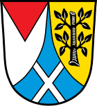
The description of the coat of arms, introduced in 1971, reads: “Split by a looped blue tip with a silver St. Andrew's cross inside; in front a red shortened and overturned point in silver, behind in gold a stunted black branch with two leafy branches on both sides. "
Culture and sights
- Every year on a Sunday at the end of October there is a big Leonhardiritt to the pilgrimage church in Grongörgen .
- In the community of Haarbach there is a carnival club, which is based in the Rainding district.
- The St. Andrew's Church in the Oberuttlau district has a remarkable painting from the late Gothic period.
Economy and Infrastructure
Economy including agriculture and forestry
In 2011, according to official statistics, there were five in the field of agriculture and forestry, 162 in the manufacturing sector and 128 in the trade and transport sector at the place of work. In other economic areas 63 people were employed at the place of work subject to social security contributions. There were a total of 960 employees at the place of residence subject to social security contributions. There were none in manufacturing and eight in construction. In addition, there were 76 farms in 2010 with an agricultural area of 2114 ha.
education
There are the following educational institutions (status: 1999):
- Kindergartens: 75 kindergarten places with 76 children
- Elementary schools: one with 13 teachers and 259 students
Sons and daughters of Haarbach
- Eduard Schleich the Elder (1812–1874), painter
- Benedikt Bachmeier (1887–1970), politician of the Bavarian Farmers' Union
- Andreas Steinhuber (1825–1907), Curia Cardinal , born in Uttlau
Web links
Individual evidence
- ↑ "Data 2" sheet, Statistical Report A1200C 202041 Population of the municipalities, districts and administrative districts 1st quarter 2020 (population based on the 2011 census) ( help ).
- ^ Municipality of Haarbach, list of official parts of the municipality / districts in the BayernPortal of the Bavarian State Ministry for Digital, accessed on August 10, 2020.
- ^ Wilhelm Volkert (ed.): Handbook of Bavarian offices, communities and courts 1799–1980 . CH Beck, Munich 1983, ISBN 3-406-09669-7 , p. 474 .
- ↑ a b Municipal council election 2020
- ↑ Mayoral election 2020
- ^ Entry on the coat of arms of Haarbach in the database of the House of Bavarian History


