
Beutelsbach (Lower Bavaria)
| coat of arms | Germany map | |
|---|---|---|

|
Coordinates: 48 ° 33 ' N , 13 ° 7' E |
|
| Basic data | ||
| State : | Bavaria | |
| Administrative region : | Lower Bavaria | |
| County : | Passau | |
| Management Community : | Aidenbach | |
| Height : | 361 m above sea level NHN | |
| Area : | 20.39 km 2 | |
| Residents: | 1176 (Dec. 31, 2019) | |
| Population density : | 58 inhabitants per km 2 | |
| Postal code : | 94501 | |
| Area code : | 08543 | |
| License plate : | PA | |
| Community key : | 09 2 75 117 | |
| Community structure: | 30 districts | |
| Address of the municipal administration: |
Dorfplatz 8 94501 Beutelsbach |
|
| Website : | ||
| First Mayor : | Michael Diewald ( CSU ) | |
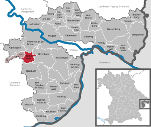
| Location of the municipality of Beutelsbach in the district of Passau | ||
  |
||

Beutelsbach is a municipality in the Lower Bavarian district of Passau . She is a member of the Aidenbach administrative community .
geography
Geographical location
Beutelsbach is located in the Danube Forest region around twelve kilometers south of Vilshofen an der Donau , 33 km west of Passau , 15 km north of Bad Griesbach im Rottal and Bad Birnbach and 22 km northeast of Pfarrkirchen .
Beutelsbach is located in the Klosterwinkel and on the edge of the woodland in the Lower Bavarian hill country .
The Aunkirchner Bach , which flows into the Vils near Aunkirchen , has its source in the south-western municipality . The 8.82 km long body of water once bore the name of the source location, namely Beutels-Bach .
Community structure
There are 30 districts:
There is only the district of Beutelsbach.
Neighboring communities
history
Until the church is planted
The community area was already settled by the Celts in pre-Christian times. Several grave fields in the community area and a Celtic square hill are evidence of this . Beutelsbach was part of the Haidenburg rule and belonged to the Landshut Rent Office and the Vilshofen Regional Court in the Electorate of Bavaria . In the course of the administrative reforms in Bavaria , today's municipality was created with the municipal edict of 1818 .

The parish of Beutelsbach was incorporated into the Cistercian monastery of Fürstenzell from 1447 to 1806 .
Population development
In the period from 1988 to 2018, the municipality grew from 1,084 to 1,180 by 96 inhabitants or 8.9%.
- 1961: 1097 inhabitants
- 1970: 1058 inhabitants
- 1987: 1082 inhabitants
- 1991: 1112 inhabitants
- 1995: 1091 inhabitants
- 2000: 1133 inhabitants
- 2005: 1109 inhabitants
- 2010: 1136 inhabitants
- 2015: 1110 inhabitants
politics
Municipal council
The municipal council has 12 members. In the local elections on March 15, 2020, 656 of the 965 residents entitled to vote in the municipality of Beutelsbach exercised their right to vote, bringing the turnout to 67.98%.
mayor
Mayor is Michael Diewald (CSU), who prevailed on December 16, 2012 with 54.9% of the votes against his opponent. In the local election on March 15, 2020, he was re-elected with 93.09% of the vote. His predecessor Josef Eglseder (CSU), who had been in office since 2002 and was confirmed in office in 2008 with 65.77% of the votes cast, died unexpectedly on September 20, 2012 at the age of 68. Its predecessor was Hans Röhrner (non-partisan voter community).
coat of arms
|
|
Blazon : "In gold under a silver-red gespickelten rafters one faces towards the left, reinforced red, black Utterschwalbe ."
Coat of arms management since 1971; Letter from the government of Lower Bavaria dated October 13, 1971 |
Declaration of the coat of arms: The so-called Uttenschwalbe (also Uttenschwalbe; not clearly defined black heraldic bird - black swan, black stork, cormorant or Waldrapp) is the heraldic animal of the barons of Closen , who as owners of the Haidenburg rulership were important land and court lords in the municipality of Beutelsbach. The rafters in silver and red, split in the form of points, are the abbey coat of arms of the Cistercian monastery Fürstenzell .
Architectural monuments
Economy and Infrastructure
Economy including agriculture and forestry
In 2017 there were 105 employees subject to social security contributions at the place of work. Of the resident population, 470 people were in employment subject to social security contributions, so that the number of out-commuters was 365 higher than that of in-commuters. 23 residents were unemployed.
In 2016 there were 40 agricultural holdings with an agriculturally used area of 1454 ha, of which 1296 ha were arable land and 158 ha were permanent grassland. In addition, there were 68 farms in 1999 with an agriculturally used area of 1363 ha, of which 1054 ha were arable land and 303 ha were permanent green space.
education
The following institutions existed (as of 2018):
- 1 day care center: 42 approved places, 34 admitted children
- 1 public primary school with 2 classes and 40 students
Others
The local apple variety is the “Beutelsbacher Rambur” apple .
Web links
- Homepage
- Entry on the coat of arms of Beutelsbach (Lower Bavaria) in the database of the House of Bavarian History
Individual evidence
- ↑ "Data 2" sheet, Statistical Report A1200C 202041 Population of the municipalities, districts and administrative districts 1st quarter 2020 (population based on the 2011 census) ( help ).
- ↑ a b Election of the first mayor of the Beutelsbach community. District of Passau, accessed on May 30, 2020 .
- ^ Municipality of Beutelsbach in the local database of the Bavarian State Library Online . Bayerische Staatsbibliothek, accessed on January 5, 2018.
- ↑ a b Election of the municipality council of Beutelsbach. District of Passau, accessed on May 30, 2020 .
- ↑ Entry on the coat of arms of Beutelsbach (Lower Bavaria) in the database of the House of Bavarian History
- ↑ Otto Titan von Hefner : Register of the flourishing and dead nobility in Germany. Volume 1: A-F. Georg Joseph Manz, Regensburg 1860, p. 237 .
Aicha in front of the forest | Aidenbach | Aldersbach | Bad Füssing | Bad Griesbach im Rottal | Beutelsbach | Breitenberg | Büchlberg | Eging am See | Fürstenstein | Fürstenzell | Haarbach | Hauzenberg | Hofkirchen | Hutthurm | Kirchham | Kößlarn | Malching | Neuburg am Inn | Neuhaus am Inn | Neukirchen vorm Wald | Obernzell | Ortenburg | Pocking | Rotthalmünster | Rowing | Ruhstorf an der Rott | Salt Trail | Suns | Tettenweis | Thyrnau | Tiefenbach | Tittling | Untergriesbach | Vilshofen on the Danube | Wegscheid | Windorf | Witzmannsberg