Untergriesbach
| coat of arms | Germany map | |
|---|---|---|

|
Coordinates: 48 ° 34 ' N , 13 ° 40' E |
|
| Basic data | ||
| State : | Bavaria | |
| Administrative region : | Lower Bavaria | |
| County : | Passau | |
| Height : | 556 m above sea level NHN | |
| Area : | 73.6 km 2 | |
| Residents: | 6089 (Dec. 31, 2019) | |
| Population density : | 83 inhabitants per km 2 | |
| Postal code : | 94107 | |
| Area code : | 08593 | |
| License plate : | PA | |
| Community key : | 09 2 75 153 | |
| Market structure: | 106 districts | |
Market administration address : |
Marktplatz 24 94107 Untergriesbach |
|
| Website : | ||
| Mayor : | Hermann Duschl (CWG) | |
| Location of the Untergriesbach market in the Passau district | ||
Untergriesbach (until 1903 Griesbach ) is a market and state-approved resort in the Lower Bavarian district of Passau .
geography
Geographical location
Untergriesbach and on the left extends far over the deeply cut valley of the Danube in the southern Bavarian Forest . The eponymous central place of the market town is at an altitude of 556 m above sea level. NHN . Via the B 388 you can reach the three-river city of Passau in the west, 22 km away, and in the opposite direction after 32 km, Upper Austrian Haslach .
Community structure
Untergriesbach has 106 districts:
- Bachhäusl
- Berghof
- Brunnreut
- Dienberg
- Diendorf
- Dürrmühle
- Corner
- Eckersäg
- Eckerstampf
- Corner mill
- Endsfelden
- Feldhäusl
- Spruce
- Spruce meadows
- Friedlgrub
- Gammertshof
- Gebrechtshof
- Law mill
- Goggling
- Gotting
- Gottsdorf
- Grögöd
- Grub
- Grünau
- Habersdorf
- Hamet
- Hanzing
- Hastorf
- Haunersdorf
- Herrnwies
- Hinterkühberg
- Back saw
- Heating
- Hochreut
- Hochwiesl
- Höhenberg
- Holzhäusl
- Hubing
- Dog jerk
- Jochenstein
- Kagerreut
- Kappelgarten
- Kinzesberg
- Knappenhäusl
- Knittlmühle
- Kohlbachmühle
- Kroding
- Kronawitten
- Kronawitthof
- Krottenthal
- Kühberg
- Lämmersdorf
- Leizesberg
- Linden trees
- Lindlmühle
- Mairau
- Middle corner
- Mitterreut
- Foggy
- Neureuth
- Niederndorf
- Oberöd
- Oberötzdorf
- Oberreut
- Ochsenreut
- Ornatsöd
- Paulusberg
- Pfaffenreut
- Creek
- Ramesberg
- Rampersdorf
- Ratzing
- Rechab
- Reut
- Judges mill
- Riedl
- Riedlerhof
- Roll
- Rothenkreuz
- Saxing
- Schaibing
- Schergendorf
- Scherleinsöd
- Carpenter's house
- Spechting
- Sperrhäusl
- Steinbruck
- Steinbüchl
- Stollberg
- Stollbergmühle
- Tobacco pound
- Taubing
- Untergriesbach
- Unteröd
- Unterötzdorf
- Unterreut
- Forewood
- Forest peace
- Weidwies
- Wesseslinden
- Willersdorf
- Worm
- Worm mill
- Fence breaker
- Decorative ring
- Zipf
history
Until the church is planted
The name comes from the nobles von Griesbach. These were a wealthy noble family with numerous possessions in the "Land of the Abbey" ( Passau Abteiland ). The first noble who named himself after Griesbach in 1108 was Albero, nicknamed Calf Grass (1096–1125). He was probably a brother of Rotbert von Polsenz-Hals . His grandson Werner marries Elisabeth von Wilhering , heiress of the Waxenberg estate (Urfahr district), their sons name themselves alternately after Griesbach and Waxenberg. Nothing has been preserved from the former castle, built between 1096 and 1108.
Originally “Griespach”, then “Griesbach on the high market” (to distinguish it from “Griesbach in der Zell” = Obernzell ), after 1806 it became Untergriesbach (to differentiate it from Griesbach im Rottal ). The former core around the church should have been a clustered village.
The nobles von Griesbach died out with Heinrich at the beginning of the 13th century, so that the bishops of Passau succeeded in integrating their domain into the prince-bishopric from 1220/21. The castle itself is believed to have been abandoned soon after.
1260 gave Bishop Otto the market rights and other privileges. In the Passau civil uprising against Bishop Albert Untergriesbach was burned down by Passau rebels in 1367. In 1443 the market received an episcopal nursing court with Peter Höpfl as the first caretaker , in 1456 Bishop Ulrich confirmed and expanded the rights and freedoms of the market.
see also ruin Altjochenstein , castle ruins Neujochenstein
Untergriesbach was largely spared from the Thirty Years War , but the Bavarian and imperial troops that were quartered here brought in the plague in the last year of the war in 1648, which raged with great violence until the beginning of 1650.
The late Gothic parish church of St. Michael was redesigned in several stages in the baroque style during the 18th century. In 1803 the market in Griesbach came to Grand Duke Ferdinand of Tuscany and in 1806 to Bavaria . In 1818 Untergriesbach adopted the magistrate constitution ( community edict of 1818 ). The trader Georg Saxinger was elected the first mayor.
19th and 20th centuries
In 1829 a new school building was built. From 1829 to 1830 a new road to Obernzell was built, which was considerably more comfortable to drive than the old mountain road.
In 1903 the name of Griesbach was officially changed to Untergriesbach .
In 1956 the Jochenstein Danube power plant was built in the municipality .
Incorporations
On October 1, 1971, the previously independent municipality of Lämmersdorf was incorporated. Gottsdorf and Schaibing were added on January 1, 1972 . Oberötzdorf followed on March 1, 1972.
Population development
Between 1988 and 2018 the market grew from 5,766 to 6,085 by 319 inhabitants or 5.5%. On December 31, 2005 Untergriesbach had 6,399 inhabitants.
politics
Market council
Based on the election results of the municipal council election on March 15, 2020 , the municipal council has been composed as follows since May 1, 2020:
| Seats | Share of votes | |
|---|---|---|
| CSU | 5 | 28.30% |
| SPD | 3 | 14.40% |
| Free community of voters | 5 | 24.40% |
| Christian voter community | 4th | 19.60% |
| Citizens' Forum Gottsdorf | 3 | 13.30% |
| total | 20th | 100.00% |
Compared to the 2014 to 2020 term of office, the CSU had to give up two seats and the Free Voting Community lost one mandate. The citizens' forum is new - with three seats - included.
mayor
Hermann Duschl (Christian Voting Association) has been mayor since April 5, 2006; he was last elected for a further six years on March 11, 2018 with 64.8% of the vote.
coat of arms
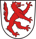
The coat of arms has been kept since about 1800 and is as follows described : "Argent, a left-facing increasing red wolf ."
Community partnerships
- The partner municipality is Civezzano in ( Trentino , Italy )
ILE compartment
The community is a member of the “Integrated Rural Development Abteiland” (ILE Abteiland) working group founded by 11 communities in April 2011, whose motto is to preserve and design the natural, cultural and economic area of Abteiland as a livable home.
Educational institutions
- kindergarten
- Primary and secondary school
- Untergriesbach grammar school
Culture
- Every three years on the second weekend in July, the home days take place in conjunction with a folk festival . Here the entire community presents itself to the outside world under a fixed motto (usually traditional).
- SAMICO - young choir: gospels, new spiritual songs
Attractions
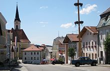
- Late Gothic parish church of St. Michael, remodeled in Baroque style in the 18th century
- Village chapel, built between 1765 and 1768
- Parish church of St. Jakob the Elder in Gottsdorf
- Pillory from 1490 as a sign of the former lower jurisdiction of the market
traffic
In 1912 Untergriesbach received a station on the Erlau – Wegscheid railway line . Rail traffic was stopped in 1965, and in 1975 the line from Obernzell to Wegscheid was dismantled.
The town of Schaibing, incorporated in 1971 on the Passau – Hauzenberg railway line , received a rail connection as early as 1904. Passenger traffic ended here in 1970 and goods traffic in 1997. Efforts are being made to reactivate this route.
The pedestrian ferry Donaunixe Isa crosses from Jochenstein to Engelhartszell in Upper Austria, it is only in operation in summer and is particularly popular with users of the Danube Cycle Path.
Sports and clubs
- The largest club in the market is SC Jochenstein with around 915 members.
- The veterans of the world wars, former and active soldiers of the Bundeswehr are organized in the (each independent) soldiers and warriors' associations in Untergriesbach, Schaibing and Gottsorf.
Sons and daughters
- Ottfried Fischer (* 1953), actor and cabaret artist
- Christian Goller (1943–2017), painter
- Theoderich Hagn (1816–1872), Benedictine, Abbot of Lambach
- Michael Höllerzeder (1898–1938), KPD politician
- Friedrich Oberneder (1891–1963), theologian and poet
- Rudolf Wimmer (1849–1915), imperial court painter
Web links
- Entry on the coat of arms of Untergriesbach in the database of the House of Bavarian History
Individual evidence
- ↑ "Data 2" sheet, Statistical Report A1200C 202041 Population of the municipalities, districts and administrative districts 1st quarter 2020 (population based on the 2011 census) ( help ).
- ↑ Markt Untergriesbach in the local database of the Bayerische Landesbibliothek Online . Bayerische Staatsbibliothek, accessed on August 20, 2018.
- ↑ a b Wilhelm Volkert (Ed.): Handbook of the Bavarian offices, communities and courts 1799–1980 . CH Beck, Munich 1983, ISBN 3-406-09669-7 , p. 590 .
- ↑ 2020 municipal council election , accessed on July 20, 2020
- ^ Origin of ILE Abteiland , accessed on April 25, 2020.
- ↑ Jochenstein Ski Club - Jochenstein Ski Club. Retrieved April 4, 2019 .


