
Witzmannsberg
| coat of arms | Germany map | |
|---|---|---|

|
Coordinates: 48 ° 43 ' N , 13 ° 25' E |
|
| Basic data | ||
| State : | Bavaria | |
| Administrative region : | Lower Bavaria | |
| County : | Passau | |
| Management Community : | Tittling | |
| Height : | 495 m above sea level NHN | |
| Area : | 18.74 km 2 | |
| Residents: | 1496 (Dec. 31, 2019) | |
| Population density : | 80 inhabitants per km 2 | |
| Postal code : | 94104 | |
| Area code : | 08504 | |
| License plate : | PA | |
| Community key : | 09 2 75 160 | |
| Community structure: | 29 districts | |
| Address of the municipal administration: |
Marktplatz 10 94104 Tittling |
|
| Website : | ||
| Mayor : | Josef Schuh ( CSU ) | |
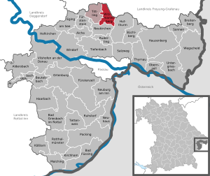
| Location of the municipality of Witzmannsberg in the district of Passau | ||
  |
||


Witzmannsberg is a municipality in the Lower Bavarian district of Passau and a member of the Tittling administrative community .
geography
Geographical location
Witzmannsberg is located in the Danube Forest region in the Bavarian Forest on the northeastern border with Freyung-Grafenau, west of the Ilz . The community is not far from the B 85 and the motorway feeder to the federal motorway 3. It is 22 km to Passau or Grafenau in the opposite direction, 26 km to Vilshofen an der Donau and 24 km to Waldkirchen .
Community structure
The municipality of Witzmannsberg has 29 districts:
|
There is only the district Witzmannsberg.
history
Witzmannsberg has been documented as an aristocratic seat since 1310. The owners of the country estate changed frequently. It is entered as Witzmansperg in the map of Philipp Apian from 1568 .
By marriage in 1688 the people of Traun came into possession of Witzmannsberg. They built a castle with a castle chapel here. From 1762 it belonged to the Counts of Taufkirchen . The place was part of the Electorate of Bavaria and formed a closed Hofmark , whose seat was Witzmannsberg. In the municipality there were also the noble seats Enzersdorf and Waltendorf. The castle was burned down in 1742 by the Pandur Colonel Franz von der Trenck and later demolished. The current political community was established in 1818 by the royal community edict of May 17, 1818.
Population development
In the period from 1988 to 2018, the municipality grew from 1,405 to 1,502 by 97 inhabitants or 6.9%.
- 1970: 1365 inhabitants
- 1987: 1402 inhabitants
- 2000: 1732 inhabitants
- 2005: 1751 inhabitants
- 2010: 1727 inhabitants
- 2015: 1468 inhabitants
politics
Municipal council
The municipal council consists of the first mayor and the councilors. Based on the results of the municipal council elections on March 15, 2020 , the distribution of seats on the committee has been as follows since May 1, 2020:
- CSU : 5 seats (43.3% of the vote)
- ÜW : 4 seats (31.3% of the votes)
- Free voter community : 3 seats (25.4% of the vote)
mayor
Mayor is Josef Schuh (CSU), who was elected in the first round of the 2008 local elections with 67.78% of the valid votes and was confirmed in office on March 16, 2014. On March 15, 2020, he was elected for a third term with 61.4% of the vote.
Finances
In 2017, the municipal tax revenue was € 1,093,000, of which the trade tax income (net) was € 348,000 and the municipal share of income tax was € 619,000. The debt per inhabitant was € 61.
coat of arms
The description of the municipal coat of arms, introduced in 1971, reads: “Split of black and gold; in front a fallen and an upright silver rafter, behind a black billy goat. "

Culture and sights
In 1704 Ignatius Freiherr von Traun, owner of the Hofmark Witzmannsberg, had a chapel built in a valley basin. Because of a well house next door, it is called the Bründl Chapel . According to legend, the sick daughter of a count was healed here by the water of a spring that had sprung up overnight. When it then snowed on Maria Schnee in the middle of August and only a single spot on the Danglwiese remained free of snow, this was taken as a sign to build a chapel here.
The chapel Maria, Heil der Kranken , crowned by an onion dome , has a rococo altar from 1765 with a copy of the miraculous image from the church of Santa Maria Maggiore in Rome . It was extensively renovated in 1976.
See also: List of architectural monuments in Witzmannsberg
Economy and Infrastructure
Economy including agriculture and forestry
In 2017 there were 194 jobs subject to social security contributions in the municipality. Of the resident population, 600 people were in employment subject to compulsory insurance. This means that the number of out-commuters was 406 more than that of in-commuters. 22 residents were unemployed. In 2016 there were 32 farms; 1215 hectares of the community area were used for agriculture.
education
There are the following facilities:
- a daycare facility with 49 places that is fully occupied (as of March 1, 2018) and
- the Witzmannsberg primary school with four teachers and 47 students
Individual evidence
- ↑ "Data 2" sheet, Statistical Report A1200C 202041 Population of the municipalities, districts and administrative districts 1st quarter 2020 (population based on the 2011 census) ( help ).
- ^ Community Witzmannsberg in the local database of the Bayerische Landesbibliothek Online . Bayerische Staatsbibliothek, accessed on January 5, 2018.
- ↑ Ordinance concerning the future constitution and administration of the communities in the kingdom in the Google book search
- ↑ 2020 municipal council and mayoral elections , accessed on July 22, 2020
- ↑ Witzmannsberg primary school in the school database of the Bavarian State Ministry for Education and Culture , accessed on July 22, 2020.
Web links
- Entry on the Witzmannsberg coat of arms in the database of the House of Bavarian History
- Official website of the municipality of Witzmannsberg
- Witzmannsberg: Official statistics of the LfStat
Aicha in front of the forest | Aidenbach | Aldersbach | Bad Füssing | Bad Griesbach im Rottal | Beutelsbach | Breitenberg | Büchlberg | Eging am See | Fürstenstein | Fürstenzell | Haarbach | Hauzenberg | Hofkirchen | Hutthurm | Kirchham | Kößlarn | Malching | Neuburg am Inn | Neuhaus am Inn | Neukirchen vorm Wald | Obernzell | Ortenburg | Pocking | Rotthalmünster | Rowing | Ruhstorf an der Rott | Salt Trail | Suns | Tettenweis | Thyrnau | Tiefenbach | Tittling | Untergriesbach | Vilshofen on the Danube | Wegscheid | Windorf | Witzmannsberg