
Kirchham (District of Passau)
| coat of arms | Germany map | |
|---|---|---|

|
Coordinates: 48 ° 21 ' N , 13 ° 16' E |
|
| Basic data | ||
| State : | Bavaria | |
| Administrative region : | Lower Bavaria | |
| County : | Passau | |
| Height : | 335 m above sea level NHN | |
| Area : | 18.48 km 2 | |
| Residents: | 2409 (Dec. 31, 2019) | |
| Population density : | 130 inhabitants per km 2 | |
| Postal code : | 94148 | |
| Primaries : | 08533, 08531, 08537 | |
| License plate : | PA | |
| Community key : | 09 2 75 130 | |
| Community structure: | 27 districts | |
| Address of the municipal administration: |
Kirchplatz 3–4 94148 Kirchham |
|
| Website : | ||
| Mayor : | Anton Freudenstein ( CSU / community welfare) | |
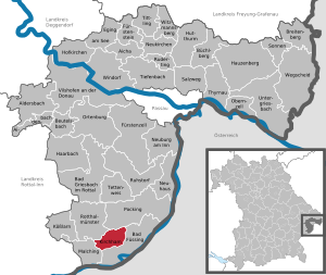
| Location of the municipality of Kirchham in the Passau district | ||
  |
||


Kirchham is a municipality in the Lower Bavarian district of Passau and a state-approved resort .
geography
Geographical location
The municipality of Kirchham in the southern district of Passau is located on the Kößlarner Bach in the middle of the Pockinger Heide , a fertile plain that extends to the nearby Inn . The place benefits on the one hand from its convenient location on the B 12 , not far from the Austrian border and close to the federal motorway 3 , but also from spa tourism, as Kirchham is located in the middle of the Lower Bavarian spa triangle . After Bad Fussing it is three kilometers to Passau km 30, after Schärding ( Upper Austria km) 20, according Pocking nine kilometers, according to Obernberg am Inn (Upper Austria) seven kilometers and after Simbach km 20th
Community structure
The municipality of Kirchham has 27 districts:
There is only the district Kirchham.
Neighboring communities
history
Until the church is planted
In 777 the "place called Chirihheim" was first mentioned in a document. Kirchham has an importance reaching back to this time as a church center and parish seat. The St. Martin's patronage of the parish church confirms this historical position as a pastoral care center for the surrounding area. The Erlbach part of the municipality has been an aristocratic seat since around 1500, and the Erlbach Hofmark has existed since 1752. Kirchham belonged to the Landshut Rent Office and the Griesbach Regional Court of the Electorate of Bavaria. Today's political municipality was created with the Bavarian municipal edict of 1818.
20th century
From March 6, 1945 to May 2, 1945, shortly before the end of the Second World War, there was a satellite camp of the Flossenbürg concentration camp , whose 400 prisoners had to do forced labor for a Viennese construction company.
In 1992 Kirchham won the silver medal in the competition " Our village should be more beautiful ", and in 1978 the place won this competition.
Population development
In the period from 1988 to 2018, the municipality grew from 2,092 to 2,355 by 263 inhabitants or 12.6%.
- 1961: 1291 inhabitants
- 1970: 1404 inhabitants
- 1987: 1969 inhabitants
- 1991: 2248 inhabitants
- 1995: 2345 inhabitants
- 2000: 2313 inhabitants
- 2005: 2427 inhabitants
- 2010: 2354 inhabitants
- 2015: 2195 inhabitants
politics
Municipal council

The municipal council consists of a total of 14 members and has been composed as follows since the local elections on March 15, 2020:
- ÜW : 7 seats (47.50% of the votes)
- CSU and the Free Voting Group Community Welfare: 6 seats (46.28% of the vote)
- Greens : 1 seat (6.23% of the vote)
mayor
Mayor has been Anton Freudenstein ( CSU / Gemeindewohl) since May 2008 , who was re-elected in 2014 with 86.98% and in the 2020 local elections with 57.48% of the valid votes.
After the municipal elections in 2014, his deputies were the 2nd mayor Margareta Haslinger (CSU / Gemeindewohl) and Wilhelm Lickl (CSU / Gemeindewohl) as the 3rd mayor. Following the 2020 election, they were replaced by ÜW municipal council members Robert Bauer and Heinz Winklhofer.
Community partnerships
There is a partnership with the municipality of the same name in Kirchham in the Upper Austrian district of Gmunden.
Culture and sights
Culture
- Cabaret potato cellar
Attractions

- The neo-baroque parish church of St. Martin was built in 1915 by the Munich architects, Gebrüder Rank , after a fire in the previous Baroque church from 1729 . It has a baroque and neo-baroque interior.
- Kirchham Castle
- Mill museum in the Tutting district
- Various listed farmhouses and farmsteads in the Rottal architectural style.
- Excavation finds from different time periods, which were mainly discovered in the district of Bach. These can be viewed free of charge in the Kirchham town hall / guest information office during opening hours.
memorial
On the site of the concentration camp cemetery near the Waldstadt district, which was dissolved in 1957, a memorial today commemorates the 95 concentration camp prisoners of a satellite camp of Mauthausen who were formerly buried here and who were housed in a former air barracks and who died here as a result of their imprisonment. The dead were transferred to the Flossenbürg Concentration Camp Memorial Cemetery .
tourism
Due to its central location in the Lower Bavarian spa triangle , Kirchham is a travel destination for spa and health tourists. Due to the high air quality, the natural environment and various spa facilities, the community has the title of state-recognized resort .
There are 26 accommodation establishments in the municipality, including two hotels, a bed and breakfast hotel and two campsites. The remaining accommodations are holiday flats / apartments and pensions.
Kirchham owns a golf course together with Bad Füssing . The 18-hole championship course of the ThermenGolfClub Bad Füssing - Kirchham is flowed through by the Kößlarner Bach as a natural obstacle and has different degrees of difficulty.
The Haslinger Hof adventure park is located in the Ed district on the border with the neighboring community of Bad Füssing.
Economy and Infrastructure
traffic
Road traffic
Kirchham is connected to the trunk road network through the federal highway 12 , which leads from Lindau via Munich to Passau and on to the German-Czech border . In addition, there is a connection to the federal motorway 3 via the B 12 in neighboring Pocking , which in the direction of Bavaria opens up parts of the Bavarian forest and the Passau region and in the direction of Austria the Innviertel .
On the route of the current B 12 resulting Bundesautobahn 94 . Kirchham will have its own entrance and exit at junction number 31. The motorway is currently under construction in this section. Thus, the absence of traffic noise in the state recognized leisure after the completion of the A 94 is further ensured, in the district creates Tutting a 450 meter housing of the roadway. The remaining route within the municipality is far from the center and inhabited areas.
In addition, in the municipality, the federal road 12 is crossed by the state road 2110 coming from Pfarrkirchen or Rotthalmünster . In its further course, this connects Kirchham to the spa town of Bad Füssing (3 km) and the state road 2117 . This leads over the Inn, which forms the Bavarian-Upper Austrian border, to Obernberg am Inn (7 km) and from there on as the L 510 .
Bus transport
Since January 1, 2013, the public transport bus has been running with the public transport bus. The route network of this local bus includes the municipality of Kirchham and the spa town of Bad Füssing and its three thermal spring baths .
There are a total of 8 stops within the municipality, which are served every hour on weekdays and on weekends. 14 other stations are located in Bad Füssing.
Originally, the connection of Kirchham to the network of the regular bus that had previously operated in Füssing was primarily intended for tourism. As a tourist bus, it was mainly intended to provide spa guests with a direct connection from the holiday home to the thermal baths and other spa facilities. In the meantime, the bus is increasingly being used by locals for work, business trips or excursions.
The fare for a single journey is € 2.20 regardless of the distance traveled (as of 2019) . This bus connection is available free of charge to Kirchham spa guests and holidaymakers. Community citizens can purchase an annual pass - the citizen card - for € 20 (as of the 2013 season) in the Kircham town hall.
Rail transport
From 1910 to 2003 Kirchham was connected to the Simbach am Inn – Pocking railway line with the Tutting station in the district of the same name, as well as a track to the Rottal barracks . In addition, the Tutting – Kößlarn railway branched off in Kirchham .
With the increase in private transport, the operation of both routes turned out to be increasingly unprofitable. As a result, the Deutsche Bundesbahn stopped passenger traffic on the Tutting-Kößlarn route on October 2, 1960 and on the Simbach-Pocking route on June 1, 1969 . On the same day, freight traffic between Simbach and Tutting was also shut down. With this, the Tutting station also lost the status of a crossing station . The same thing happened on January 1, 1970 with the Rotthalmünster Kößlarn section, which was dismantled from February 1972.
After the remaining section of the Tutting-Kößlarn line was abandoned in 1996, only the Bundeswehr transports from the Rottal barracks remained, which had to be transhipped at the Tutting station, as the siding to the barracks had already been dismantled.
When the barracks were closed in 2002, the remaining line between Pocking and Kirchham also lost its last use and was shut down on April 23, 2003.
In 2007 the track systems were dismantled and removed and the construction of a footpath and cycle path began, the course of which is based on the former route. Thus old railway structures, such as bridges or railway embankments, were given a new function as part of the newly created leisure route between Pocking and Kirchham.
In 2008 all measures were completed and the "Alter Bahndamm" footpath and cycle path opened.
Economy including agriculture and forestry
According to official statistics, there were 7 employees at the place of work in the field of agriculture and forestry, 67 in the manufacturing sector and 65 in trade and transport. In other economic sectors 406 people were employed at the place of work subject to social security contributions. There were a total of 656 employees at the place of residence subject to social insurance contributions. There were two companies in the manufacturing sector and three in the construction sector. In addition, in 1999 there were 52 farms with an agricultural area of 1209 ha, of which 1111 ha were arable land and 89 ha were permanent green space.
Kirchham has a strong focus on tourism, mainly on spa guests in the spa triangle of Bad Füssing , Bad Griesbach and Bad Birnbach .
education
There are the following facilities:
- Kindergartens: 75 kindergarten places
- Primary school: 1st - 4th grade
Former Bundeswehr base
The municipality of Kirchham was the location of the Bundeswehr Army . The Rottal barracks was built in the early 1960s. Mainly tank units were stationed there. The area was given up in 2003.
When the Iron Curtain fell in 1989 and the East opened its borders, the barracks served as a refugee and reception center for GDR citizens who came to West Germany via Hungary and Austria. Due to the eastern location and the proximity to the Austrian border, the Bundeswehr location was the first point of contact for many people and was accordingly highly frequented.
On the site of the former site training area there is now a solar park, which in cooperation with the municipality of Bad Fussing and the city of Pocking arose.
Personalities
- Michael Stapfer (1871–1950), politician
Individual evidence
- ↑ "Data 2" sheet, Statistical Report A1200C 202041 Population of the municipalities, districts and administrative districts 1st quarter 2020 (population based on the 2011 census) ( help ).
- ↑ Kirchham districts. In: Bayerische Landesbibliothek Online (BLO). Retrieved March 28, 2020 .
- ↑ a b Kirchham subcamp. Website of the Flossenbürg Concentration Camp Memorial. Retrieved July 6, 2016.
- ↑ Election of the municipal council - municipal elections 2020 in the municipality of Kirchham - overall result. District of Passau, accessed on March 29, 2020 .
- ↑ Election of the first mayor - municipal elections 2020 in the municipality of Kirchham - overall result. District of Passau, accessed on March 28, 2020 .
- ↑ Municipal Council. Kirchham parish, accessed on May 18, 2020 .
- ↑ Memorial sites for the victims of National Socialism. A documentation, volume 1. Federal Agency for Civic Education, Bonn 1995, ISBN 3-89331-208-0 , p. 155
- ↑ Bath bus timetable. In: kirchham.de. Retrieved March 8, 2019 .
- ^ Kindergarten St. Martin in Kirchham. Retrieved February 24, 2019 .
Web links
- Entry on the coat of arms of Kirchham (Passau district) in the database of the House of Bavarian History
Aicha in front of the forest | Aidenbach | Aldersbach | Bad Füssing | Bad Griesbach im Rottal | Beutelsbach | Breitenberg | Büchlberg | Eging am See | Fürstenstein | Fürstenzell | Haarbach | Hauzenberg | Hofkirchen | Hutthurm | Kirchham | Kößlarn | Malching | Neuburg am Inn | Neuhaus am Inn | Neukirchen vorm Wald | Obernzell | Ortenburg | Pocking | Rotthalmünster | Rowing | Ruhstorf an der Rott | Salt Trail | Suns | Tettenweis | Thyrnau | Tiefenbach | Tittling | Untergriesbach | Vilshofen on the Danube | Wegscheid | Windorf | Witzmannsberg