Schärding
|
Borough Schärding
|
||
|---|---|---|
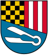
| coat of arms | Austria map | |
|
|
||
| Basic data | ||
| Country: | Austria | |
| State : | Upper Austria | |
| Political District : | Schärding | |
| License plate : | SD | |
| Main town : | Schärding Inner City | |
| Surface: | 3.96 km² | |
| Coordinates : | 48 ° 27 ' N , 13 ° 26' E | |
| Height : | 313 m above sea level A. | |
| Residents : | 5,269 (January 1, 2020) | |
| Population density : | 1331 inhabitants per km² | |
| Postal code : | 4780 | |
| Area code : | 07712 | |
| Community code : | 4 14 22 | |
| NUTS region | AT311 | |
| Address of the municipal administration: |
Unterer Stadtplatz 1 4780 Schärding |
|
| Website: | ||
| politics | ||
| Mayor : | Franz Xaver Angerer ( ÖVP ) | |
|
Municipal Council : (2015) (31 members) |
||
| Location of Schärding in the Schärding district | ||
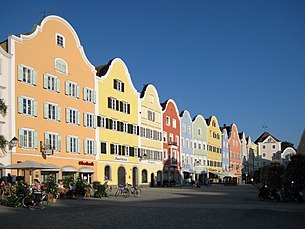
 Silberzeile (Upper Town Square) |
||
| Source: Municipal data from Statistics Austria | ||
Schärding ( Upper Austrian : Scháréng) is a town in Upper Austria with 5269 inhabitants (as of January 1, 2020). Schärding is known as a baroque town on the Inn , with its numerous baroque town houses and historical squares. It is the district capital of the Schärding district and at the same time the local center for the surrounding district.
geography
The city is located on the Inn River , 15 km south of Passau , on the western edge of the Innviertel . Two different natural spaces meet in Schärding . The hilly Sauwald , part of the Bohemian Massif in the north and the expiring plain of the Inn Valley to the south . The city is 313 m above sea level in the Innviertel. The extension is 4.1 km from north to south and 1.9 km from west to east. The total area is 4.08 km². 2.4% of the area is forested, 31.7% is used for agriculture.
The Inn forms the border to the neighboring Free State of Bavaria . Directly opposite, on the Bavarian side of the Inn, is the community of Neuhaus am Inn , which can be reached via two bridges.
Districts
The community consists of the cadastral communities Schärding-Stadt and Schärding-Vorstadt. The municipality includes the following five localities (population in brackets as of January 1, 2020):
- All Saints' Day (871)
- Brunnwies (210)
- Kreuzberg (286)
- Schärding Inner City (597)
- Schärding suburb (3305)
Neighboring communities
| Wernstein am Inn | ||
| Neuhaus am Inn |

|
Brunnenthal |
| St. Florian am Inn |
Population development

From 1981 to 2011 the population decreased due to a negative birth balance despite immigration.
history
The area around Schärding was settled since the Neolithic Age. The first settlements are documented by archaeological finds (hole axes or flat hatchets) along the courses of the Antiesen, Inn and Pram rivers in the Neolithic Age. Before in 15 BC When the Romans advanced as far as the Danube and the Innbaiern and Schärding became part of the Roman province of Noricum , Celts settled the area. In 488 AD, King Odoacer had his troops withdraw to the south.
West Germanic Bavarians migrated up the Danube about 30 years later and occupied the area between the Vienna Woods and Lech. The place names ending in -ing , -ham and -heim clearly indicate the conquest. The name of the district town 'Scardinga' comes from the name for the settlement of a Scardo with his clan.
Schärding was first mentioned in a document in 804 as the Passauer Gutshof scardinga . The geographically favorable location of the castle rock in the immediate vicinity of the Inn was used early on to build a fortification.
Since the 10th century, the place developed through the lucrative trade on the Inn as a market center and seat of the county of Schärding under the Bavarian families Formbach-Neuburg . From 1160 it belonged to the Andechs-Meranien and from 1248 to 1504 the Wittelsbacher .
At the time of the early church organization in the Middle Ages, Schärding belonged to the original parish of St. Weihflorian . Like the Münzkirchen parish , this consisted of areas that had belonged to the St. Severin parish in Passau's Innstadt . St. Weihflorian was first designated as an independent parish in 1182 when it was incorporated into the Passau “Innbruckamt”, which was subordinate to the St. Aegidien Hospital in the city center. The parish of St. Weihflorian was very extensive: it lay between the area of activity of the original parish of St. Severin and that of the original parish of Münsteuer and included the area of today's parishes of Brunnenthal , Schärding, St. Florian am Inn , Suben , St. Marienkirchen and Eggerding , plus shares in today's parishes of Taufkirchen , Lambrechte and Rainbach . When the parish of St. Weihflorian was relocated to Schärding in 1380 , the town itself became a parish.
Due to the favorable location on the Inn, Schärding developed into a large trading center, especially for salt, wood, ores, wine, silk, glass, grain, cloth goods and cattle. At the end of the 13th century, the place was given market rights. After frequent changes of ownership in the 14th century, Schärding was elevated to the status of town for the first time on January 20, 1316 (by the Wittelsbachers) and later on September 24, 1364 (by Rudolf IV of Habsburg ). In 1369 the Peace of Schärding ended the dispute between Bavaria and Austria over Tyrol , and Schärding , which was pledged to Habsburg, came back to Bavaria.

From 1429 to 1436 the city's fortifications were expanded by Duke Ludwig the Bearded . Among other things, the outer castle gate, the city moat, the Linzer and Passau gates and the water gate were built in the course of these construction measures. In 1527 the Lutheran reform theologian Leonhard Kaiser was executed here. During the Thirty Years War, particularly in 1628, 1634, 1645, 1647 and 1651, plague epidemics raged in the city. As a result of the War of the Bavarian Succession, in the Peace Treaty of Teschen in 1779, the Innviertel (Innbaiern), which had been Bavarian until then, and thus Schärding as well, was awarded to the Habsburgs . After the Napoleonic Wars in which the city burned down on April 26, 1809 and the Innviertel returned to Bavaria with the Peace of Paris in 1810, the city returned to the Habsburg sphere of influence after the Congress of Vienna in 1816 and was suddenly on the edge of the State; the old trade connections were cut off by a customs border. Already after the first annexation to the Habsburg countries in 1779, the salt trade had come to a standstill, as Austria obtained the salt from the Salzkammergut and, moreover, the salt trade was a state monopoly . In addition, with the establishment of the railways, the Inn lost its importance as a traffic route. The associated economic stagnation is the reason why Schärding today has an almost completely preserved historical townscape in the typical Inn-Salzach architecture.
Culture and sights
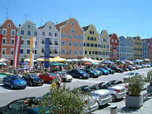
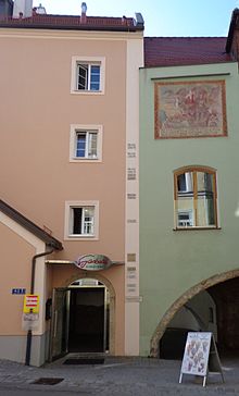
- City center: One of the sights is the cityscape with town houses from the 16th to 19th centuries, in particular the late Baroque Silberzeile on the upper town square, surrounded by a largely preserved town wall with several medieval town gates (Wassertor, Linzer Tor, Passauer Tor). Schärding in its closed, colorful baroque architecture is a typical representative of the Inn-Salzach style .
- Catholic parish church Schärding hl. Georg: Erected in the middle of the 14th century, redesigned in Baroque style from 1720 to 1726
- Kirche am Stein: The Kirche am Stein was built as St. Sebastian's Church after a plague epidemic in the 17th century. Under Joseph II it was profaned , later used as a magazine and theater for other purposes. Today it serves as a place of worship for the Protestant community.
- Former Heilig-Geist-Bürgerspitalkirche: It goes back to a foundation in 1474. In 1809 it burned down completely and could not be repaired due to the financial emergency of the city. In 1819 it was profaned. In recent years the building has housed the city library and now serves as a hotel. The preserved Gothic red marble portal with rich relief in the tympanum is remarkable .
- City Museum: The museum is located in the former Vorburgtor and shows the development of the city and its surroundings over the course of history.
- Upper Austrian Provincial Exhibition 2004: From April 23rd to November 2nd, 2004 the first Bavarian- Upper Austrian provincial exhibition took place in Schärding, Asbach , Reichersberg and Passau under the motto Limitless - History of the People on the Inn .
Sports
- In 2009, 2010 and 2011 the Race Around Austria started and finished on the town square in Schärding.
societies
- SK Schärding , the oldest soccer club in Schärding. The SKS was founded in 1922 and played 12 seasons in the third highest Austrian division.
- ATSV Schärding
- ÖTB - TV Schärding 1862
- TV Schärding
- Sports facilities
- District sports hall
- sport Center
- SK Schärding racetrack stadium
- ATSV Schärding sports field
Schärding is a member of the Small Historical Cities Association .
economy

The economy is predominantly geared towards the service sector (especially personal, social and public services and tourism ), in which around 70% of the workforce is employed. The Schärdinger Dairy Association , the Kapsreiter Group , once belonged to the most important companies in the city . With the Jos. Baumgartner is still an important company in the food industry. Another big employer is the Hennlich company.
Schärding-Neuhaus power plant : The Schärding-Neuhaus run-of- river power plant , which was built in 1961 and has an output of 96 MW, is located between Schärding and the Neuhaus am Inn opposite .
In 2011, construction began on the biomass heating plant , which in Schärding has a district heating network of 5,000 meters in length and supplies up to 17,000 MWh of bio-heating. The biomass plant was opened in 2014.
traffic
- Road: Schärding is close to the Innkreisautobahn A8, which leads from Wels to Passau and (as the German A3) to Regensburg . The federal road network connects to the German road network through 2 Inn bridges.
- Rail: Schärding is located on the branch of the Western Railway leading to Passau and is thus connected to the greater Linz area and eastern Austria as well as to Germany and all of Western Europe. Schärding train station is the starting point for the route to Ried im Innkreis and on to Attnang-Puchheim ( Salzkammergutbahn ) or Braunau am Inn with continuation in Germany via Mühldorf to Munich ( Innkreisbahn from Ried)
- Shipping: Shipping on the Inn is only of tourist significance today, as the Inn power plants are not equipped with navigable locks.
Administrations
As a local center, Schärding is the seat of the district administrative authority and lower-level state authorities.
- District Commission
- District Court
- Tax office
- Office of the land surveying office in Ried im Innkreis
other departments
- Branch of the Upper Austrian regional health insurance fund
- District Police Command and Police Inspectorate
- City Police
- Post office
health
- State Hospital ( Upper Austria Health and Spitals AG )
- Schärding Medical Center (Gahleitner & Stern OG)
- District retirement and nursing home
- Brothers of Mercy Kneipp and Health Center
education
- Elementary school
- Main music school Schärding (H1)
- Sports secondary school Schärding (H2)
- Secondary school for health and new media
- General special school
- professional school
- Agricultural school (Otterbach - part of St. Florian / Inn)
- Polytechnic school
- Vocational school for commercial apprenticeships
- Agricultural vocational and technical school
- Shipmaster's School Inn-Danube
- Bundesgymnasium and Bundesrealgymnasium
- Federal Commercial School
- Federal Trade Academy
- Federal upper level secondary school with a social-communicative and vocal focus
- Vocational Promotion Institute (BFI) - adult education
- State Music School Schärding
- City library (public library and media library ) in Schloßgasse
- Adult Education Schärding (VHS) - adult education
- Economic Development Institute (WIFI)
religion
83.5% of the inhabitants of Schärding are Roman Catholic . The second largest religious community is Islam with 5.0% of the population. 2.8% of the population are evangelical ; 5.6% are without religious belief.
politics
The municipal council consists of 31 members.
| Election 2003 | Election 2009 | Election 2015 | |
|---|---|---|---|
| ÖVP | 14th | 13 | 13 |
| SPÖ | 13 | 12 | 10 |
| FPÖ | 4th | 6th | 8th |
Mayor (since 1850):
- 1850–1870: Josef Kyrle
- 1870–1876: Franz Reiss
- 1876–1898: Ludwig Pfliegl
- 1898–1911: Karl Altmann
- 1911–1913: Eduard Kyrle
- 1913–1919: Markus Hölzl
- 1919–1920: Ferdinand Brunner
- 1920–1928: Franz Birek
- 1928–1931: Josef Brandstätter
- 1931–1938: August Schmidbauer
- 1938–1945: Hans Ominger
- 1945–1946: Franz Graninger
- 1946–1949: Alois Diethör
- 1949–1967: Franz Danninger
- 1967–1981: Herbert Wöhl
- 1981–2003: Ferdinand Gstöttner
- 2003– : Franz Xaver Angerer
Personalities
Sons and daughters of the church
- Rupert Ignaz Mayr (1646–1712), violinist, composer and court conductor
- Johann Marian von Leyden , district judge von Schärding, was a member of the five-person board of directors of the Braunau parliament , which met from December 21, 1705 to January 17, 1706
- Michael Denis (1729–1800), Jesuit and court poet ( Tauet, heaven, the righteous )
- Johann Ev. Lamprecht (1816–1895), clergyman, local researcher and cartographer
- Leopold Scheibl (1817–1894), Mayor of the City of Salzburg 1885–88
- Karl Wagner von Inngau (1819–1893), President of the Vienna Commercial Court
- Hans Zötl (1846–1938), regional judge and founder of the Franz Stelzhamer Association
- Georg Wieninger (1859–1925), beer brewer, politician and agricultural scientist; Honorary citizen of Schärding
- Josef Kyrle (1880–1926), dermatologist
- Max Hirschenauer (1885–1955), landscape, genre and portrait painter
- Georg Kyrle (1887–1937), prehistorian and speleologist
- Gustav Kapsreiter (1893–1971), industrialist, art patron and politician
- Adele Obermayr (1894–1972), politician (SPÖ)
- Ernst Degn (1904–1990), painter
- Albert Bruckmayr (1913–1982), Benedictine abbot in Kremsmünster Abbey
- Ernst Dürr (1921–2002), Vice Mayor of Schärding and Member of the State Parliament (SPÖ)
- Karl Mayr (1936–2020), entrepreneur and founder of Fussl Modestrasse
- Gerhard Botz (* 1941), historian
- Ferdinand Gstöttner (1942-2018), politician (SPÖ)
- Edith Schreiber-Wicke (* 1943), children's and youth author
- Wolfgang Mayr (* 1944), journalist and editor-in-chief of the Austria Press Agency
- Hans Schafranek (* 1951), contemporary historian and journalist
- Hans Hurch (1952–2017), Director of the Viennale (Vienna Film Festival)
- Roger Reidinger (* 1957), a. o. University professor for Scandinavian studies
- Fritz Egger (* 1960), actor and cabaret artist
- Uli Marchsteiner (* 1961), designer and curator
- Priska Riedl (* 1964), visual artist and university professor for textile art design
- Thomas Weber (* 1965), painter and graphic artist
- Richard Gierlinger (* 1967), minor planet discoverer, member of the Royal Astronomical Society, operator of the Gaisberg observatory - IAU observatory B21 of the MPC / Cambridge
- Rosemarie Kaufmann , painter
- Raphael M. Bonelli (* 1968), neuroscientist, psychiatrist and systemic psychotherapist
- Walter Ablinger (* 1969), disabled athlete
- Gerhard Lessky (* 1969), conductor
- Anette Smolka-Woldan (* 1969), carpenter, restorer, painter, graphic artist, caricaturist and illustrator
- Karl-Michael Ebner (* 1972), opera singer, artistic director, president of the Austrian Music Theater Prize, founder of the Steyr music festival, member of the Vienna Volksoper
- Thomas Schererbauer (* 1972), politician, member of the Federal Council
- Helmut Oblinger (* 1973), slalom canoeist
- Michael Angerschmid (* 1974), soccer player
- Pamela Ecker (* 1974), painter, musician and music teacher
- Marlene Morreis (* 1976), actress
- Andreas Baumgartner (* 1981), ski jumper
- Lukas t (* 1992), discus thrower
People related to the community
- Leonhard Kaiser (1480–1527), Lutheran theologian and preacher, was burned on August 16, 1527 as a heretic outside the city walls on the banks of the Inn. A memorial stone was erected in his honor in 1927.
- Carl von Schwarz (1817–1898), honorary citizen of Schärding, built the high-spring water pipe and the high-jet fountain formerly located on the town square
- Margret Bilger (1904–1971), artist and glass painter, died in Schärding
- Gustav Aduatz (1908–1991), architect, city architect of Schärding, buried in Schärding
- Johanna Dorn-Fladerer (1913–1988), Austrian artist, buried in Schärding
- Elfriede Engl (* 1920), art historian, educator and author
- Franz Engl (1914–1995), local politician, grammar school director, author and curator of the home in Schärding
- Hermann Zittmayr (1926–2001), head of the Schärdinger Dairy Association , buried in Schärding
- Alois Riedl (* 1935), painter and draftsman, lives and works in Schärding
- Rudolf Lessky (* 1935), secondary school teacher, music teacher, church musician and composer
- Irmin Frank (1939–2010), textile artist
- Lutz Weinzinger (* 1943), state and federal politician, lives and works in Schärding
- Wolfgang Stöffelmayr (* 1950), music school director in Schärding and concert pianist (music in the salon)
- Ernst Schmid (* 1958), teacher and writer, he spent his childhood and youth in Schärding
- Violetta Oblinger-Peters (* 1977), slalom canoeist , lives in Schärding
Others
The minor planet (178243) Schaerding was named in the name of his hometown by its discoverer, Richard Gierlinger (Gaisberg observatory in Rainbach ).
literature
- Johann Ev. Lamprecht: Description of the Imperial and Royal Upper Austrian Gränzstadt Schärding am Inn and its surroundings. Historically, topographically and statistically illuminated . Wels 1860 ( digitized version )
- Johann Ev. Lamprecht: Historical-topographical and statistical description of the imperial royal town of Schärding am Inn. Self-published by the municipality of Schärding, Schärding 1887. Reprinted in 2002.
- City of Schärding (ed.): Chronicle of the city of Schärding am Inn. From the late 19th century to the present. Schärding 1991.
- Franz Engl: Schärding am Inn. A guide through the city and history. Eduard Wiesner, Wernstein 1991.
- Franz Engl: The home in Schärding am Inn. In: Upper Austrian homeland sheets . Issue 3/4, Linz 1956, pp. 116–121, online (PDF; 1.1 MB) in the forum OoeGeschichte.at.
- Franz Engl: The castle of Schärding: bulwark and quarry. Rieder Volkszeitung, year 108, 1988, no.43.
- Franz Engl: The Schärdinger Artists' Circle. Innviertel artists' guild. Jb. 1966/67, Ried 1966, pp. 5-28. Concerns Alfred Kubin , Max Hirschenauer, Margret Bilger, Ernst Degn, Alois Dorn , Herbert Fladerer , Johanna Dorn-Fladerer, Conrad Dorn , Käthe Herrmann-Bernhofer , Josef Diethör .
- Rudolf Flotzinger : Schärding. In: Oesterreichisches Musiklexikon . Online edition, Vienna 2002 ff., ISBN 3-7001-3077-5 ; Print edition: Volume 4, Verlag der Österreichischen Akademie der Wissenschaften, Vienna 2005, ISBN 3-7001-3046-5 .
Web links
- Official website
- Map in the Digital Upper Austrian Room Information System ( DORIS )
- 41422 - Schärding. Community data, Statistics Austria .
- More information about the community of Schärding on the geo-information system of the federal state of Upper Austria .
Individual evidence
- ↑ https://www.oberoesterreich.at/oesterreich/ort/430001189/barockstadt-schaerding.html Barockstadt Schärding
- ↑ Statistics Austria: Population on January 1st, 2020 by locality (area status on January 1st, 2020) , ( CSV )
- ↑ Statistics Austria, A look at the community Schärding, population development. Retrieved April 16, 2019 .
- ↑ Johann Ev. Lamprecht : Description of the kk landesfürstl. Gränzstadt Schärding am Inn and its surroundings. Wels 1860 ( online ), p. 276.
- ↑ Johann Ev. Lamprecht : Description of the kk landesfürstl. Gränzstadt Schärding am Inn and its surroundings. Wels 1860 ( online ), p. 275.
- ^ Hugo Lerch: The dispute between the Passau canon and Innbruckmaster Johann von Malenthein with the Passau cathedral chapter 1544–1549. In: Ostbairische Grenzmarken 6 (1962/1963), pp. 249–261, here pp. 250–251.
- ^ Theodor Ebner: Die Antiesenmünd , in: Jahrbuch des Oberösterreichischen Musealverein 148 (2003), pp. 257–284 ( online ), here p. 279.
- ↑ Johann Ev. Lamprecht : Description of the kk landesfürstl. Gränzstadt Schärding am Inn and its surroundings. Wels 1860 ( online ), p. 276.
- ^ Austrian Biomass Association: Biomass heating plant opened in Schärding
- ↑ Schärding: Plans, permits and contracts with future wood suppliers are on track, now the excavators for a biomass cogeneration plant are in motion ... Upper Austria. Online GmbH & Co.KG; Retrieved April 2, 2011
- ↑ B3 Energy: Baroque city relies on natural heat from biomass. Oberösterreichische Nachrichten, May 16, 2014, accessed on October 9, 2017 .
- ^ Province of Upper Austria, results of the 2015 elections. Retrieved on April 16, 2019 .
- ^ Rosemarie Kaufmann , in: Regiowiki.at website
- ↑ Pamela Ecker, in: Web presence of www.regiowiki.at
- ^ Elfriede Engl, in: Web presence of Regiowiki.at
- ^ Franz Engl, in: Web presence of Regiowiki.at
- ↑ Wolfgang Stöffelmayr, in: Regiowiki.at website
- ↑ Conrad Dorn. In: website of Regiowiki.at.


