Rainbach im Innkreis
|
Rainbach im Innkreis
|
||
|---|---|---|
| coat of arms | Austria map | |
|
|
||
| Basic data | ||
| Country: | Austria | |
| State : | Upper Austria | |
| Political District : | Schärding | |
| License plate : | SD | |
| Surface: | 24.41 km² | |
| Coordinates : | 48 ° 27 ' N , 13 ° 32' E | |
| Height : | 371 m above sea level A. | |
| Residents : | 1,490 (January 1, 2020) | |
| Postcodes : | 4791, 4776 | |
| Area code : | 07716 | |
| Community code : | 4 14 15 | |
| NUTS region | AT311 | |
| Address of the municipal administration: |
Rainbach im Innkreis 50 4791 Rainbach im Innkreis |
|
| Website: | ||
| politics | ||
| Mayor : | Gerhard Harant ( FPÖ ) | |
|
Municipal Council : (2015) (19 members) |
||
| Location of Rainbach im Innkreis in the Schärding district | ||
| Source: Municipal data from Statistics Austria | ||
Rainbach im Innkreis is a municipality in Upper Austria in the district of Schärding in the Innviertel with 1490 inhabitants (as of January 1, 2020). The community is located in the judicial district of Schärding . The community takes its name from the river of the same name .
geography
Rainbach im Innkreis is 371 m above sea level in the Innviertel. The extension is 9.4 km from north to south and 5.3 km from west to east. The total area is 24.5 km². 20.8% of the area is forested, 71.8% of the area is used for agriculture.
Community structure
The municipality includes the following 19 localities (residents as of January 1, 2020):
- Berndlsiedlung (15)
- Done (7)
- Haselbach (66) including Haselbach-scattered houses
- Hauzing (276) including the Hauzing settlement
- Hingsham (199) including Espernberg and Hingsham settlement
- Höcking (89) including Hanslau
- Höretzberg (135) including Böhring and Dannerding
- Kapfham (3)
- Korneredt (41) including Radenberg and Rampesau
- Ortenholz (10)
- Pfaffing (141) including Pfaffing-scattered houses
- Rainbach im Innkreis (168)
- Randolfing (41)
- Salling (58)
- Sinzing (42)
- Steinberg (35) including Steinedt
- Sumetsrad (94) including this mountain, Loh and Strößberg
- Weizenau (10)
- Wienering (60) including Edermaning
The community consists of the cadastral communities Edermaning, Grünberg, Rainbach and Wienering.
Population development
In 1991 the municipality had 1,457 inhabitants according to the census, in 2001 it had 1,493 inhabitants. In October 2013, 1503 inhabitants were registered.
coat of arms
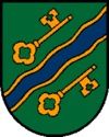
Official description of the municipal coat of arms: "In green a blue, golden bordered, obliquely left wavy bar, accompanied according to the figure by two golden keys with turned away beards and handles in four-pass shape." The municipality colors are green, yellow and blue.
history
Since the founding of the Duchy of Bavaria, the place was Bavarian until 1779 and came to Austria after the Treaty of Teschen with the Innviertel (then Innbaiern ). Briefly Bavarian again during the Napoleonic Wars , since 1814 it has finally belonged to Upper Austria.
After the annexation of Austria to the German Reich on March 13, 1938, the place belonged to the Gau Oberdonau . In 1945 Upper Austria was restored.
politics
- mayor
- until 2009 Alois Gimplinger (ÖVP)
- 2009–2015 Alois Boxrucker (ÖVP)
- since 2015 Gerhard Harant (FPÖ)
Culture and sights
- Catholic parish church Rainbach im Innkreis
- Rainbach Gospel Games: The Gospel Games have been held annually since 2004. Listed under the title Passion in the first year , these games are steadily establishing themselves in the cultural calendar.
- The Sumetsrad and Steinberg castle stables are located in the municipality .
leisure
- Adventure pool
Personalities
- Friedrich Ch. Zauner (* 1936), writer; born in Rainbach, honorary citizen of the community
- Werner Thanecker (1962–2014), provost of the Augustinian canons of Reichersberg ; born in Rainbach
- Lorenz Raab (* 1975), trumpeter ; grew up in Rainbach
Web links
- Map in the Digital Upper Austrian Room Information System ( DORIS )
- More information about the community of Rainbach im Innkreis on the geographic information system of the federal state of Upper Austria .
Individual evidence
- ↑ Statistics Austria: Population on January 1st, 2020 by locality (area status on January 1st, 2020) , ( CSV )
- ↑ Facts and figures from the community of Rainbach im Innkreis , accessed on May 28, 2014
- ^ State of Upper Austria, history and geography, coat of arms. Retrieved April 16, 2019 .
- ^ Province of Upper Austria, results of the 2015 elections. Retrieved on April 16, 2019 .


