Esternberg
|
Esternberg
|
||
|---|---|---|
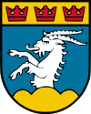
| coat of arms | Austria map | |
|
|
||
| Basic data | ||
| Country: | Austria | |
| State : | Upper Austria | |
| Political District : | Schärding | |
| License plate : | SD | |
| Surface: | 40.27 km² | |
| Coordinates : | 48 ° 33 ' N , 13 ° 34' E | |
| Height : | 510 m above sea level A. | |
| Residents : | 2,866 (Jan 1, 2020) | |
| Population density : | 71 inhabitants per km² | |
| Postal code : | 4092 | |
| Area code : | 07714 | |
| Community code : | 4 14 09 | |
| NUTS region | AT311 | |
| Address of the municipal administration: |
Hauptstrasse 33 4092 Esternberg |
|
| Website: | ||
| politics | ||
| Mayor : | Rudolf Haas ( ÖVP ) | |
|
Municipal Council : (2015) (25 members) |
||
| Location of Esternberg in the Schärding district | ||
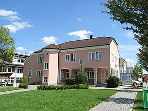
 The Esternberg municipal office |
||
| Source: Municipal data from Statistics Austria | ||
Esternberg is a municipality in the district of Schärding in the Innviertel in Upper Austria with 2866 inhabitants (as of January 1, 2020). The community is located in the judicial district of Schärding .
geography
Esternberg lies at an altitude of 510 m in the Innviertel. The extension is 8.2 km from north to south and 7.4 km from west to east. The total area is 40.3 km². This makes it the largest municipality in the Schärding district. 43.4% of the area is forested, 46.9% of the area is used for agriculture.
Community structure
The municipality includes the following 23 localities (population in brackets as of January 1, 2020):
|
|
The community consists of the cadastral communities Kiesdorf, Pyrawang, Urschendorf and Wetzendorf.
history
Since the founding of the Duchy of Bavaria, the place was Bavarian until 1779 and came to Austria after the Treaty of Teschen with the Innviertel (then 'Innbaiern'). Briefly Bavarian again during the Napoleonic Wars , since 1814 it has finally belonged to Upper Austria.
After the annexation of Austria to the German Reich on March 13, 1938, the place belonged to the Gau Oberdonau . After 1945 the restoration of Upper Austria took place.
coat of arms
Blazon : A silver goat growing under a golden shield head with three red leaf crowns in blue from a golden three-mountain. The community colors are red-white-blue.
Explanation: The main motif is reminiscent of the legend of the tailor from Krempelstein Castle (Schneiderschlössl). The three crowns are a reference to the Ostlandfahrt described in the Nibelungenlied by the Burgundian kings Gunther, Gernot and Giselher, which, after crossing the Inn, led south of Passau on the land route through today's municipality. The red color of the crowns means the bloody end of this company. The Dreiberg speaks for the place name.
politics
Since 2015, 11 of the 25 seats in the municipal council have been in the ÖVP, 10 in the FPÖ, 3 in the Greens and one in the SPÖ.
mayor
- 2005-2015: Irmgard Wirth (first mayor in Esternberg and in the district of Schärding) (ÖVP)
- since 2015: Rudolf Haas (ÖVP)
Population development
In 1991 the community had 2,694 inhabitants, in 2001 it had 2,816 inhabitants. The increase was due to the positive birth balance despite a negative migration balance . From 2001 to 2011 the birth balance was negative (–26), but this was offset by immigration, so that the population rose to 2,902 in 2011.
Town twinning
Culture and sights
- Parish church Esternberg : The church has a 47 meter high steeple with a floor plan of 8 × 8 m, the parish patron, St. Consecrated to Bartholomew; in the middle of the neo-Gothic high altar is a representation of St. Bartholomew
- Pyrawang branch church : The church is a Petruskirche and indicates an early construction period. In 1982, during the interior restoration, remains of Gothic wall paintings from the 14th century were found. exposed
- Krempelstein Castle : The castle is also called the Schneiderschlössl due to a legend . It consists of an old residential tower and an attached palace. The former curtain wall is still partially preserved.
- Theater: since 2000 there has been a theater company that regularly offers theater performances every spring.
- Culture: The "Kulturverein Voll abgefahrn!" Has existed since 2016, organizing trips to cultural events and regular concert evenings.
Sports
- The football club Union Sportverein Esternberg (SVE) was founded on July 20, 1952. The SVE's home games are played in the Heinz Ertl Stadium , which was named after the founding member and long-time President Heinz Ertl († April 9, 2014 ) . The biggest success so far was the Upper Austrian regional league championship title in 1996 and the associated promotion to the regional league middle (third highest league in Austria) . The club currently plays in the Upper Austrian Regional League West (5th performance class). The SVE's youth department has been organizing the youth indoor cup in the Schärding district sports hall at the turn of the year since 1991 for all age groups. With 9 tournament days and over 200 participating teams each year, this is one of the largest youth tournaments in Austria. Teams from 19 nations such as Belgium , Brazil , China , Germany , Denmark , England , Finland , France , Croatia , the Netherlands , Austria , Poland , Romania , Scotland , Switzerland , Slovakia , Slovenia , the Czech Republic and Hungary were guests .
- The volleyball club VC Esternberg was founded on April 26, 1976 on the initiative of Heinz-Peter Zauner. The greatest successes of the women's (1990) and men's (1991, 1994, 2017, 2018) teams were the Upper Austrian championship title.
Public facilities
- Austrian Red Cross: The RK Ortstelle Esternberg was founded in 1995.
- District elderly and nursing home Esternberg: was built by the Schärding social welfare association as the client and has been open since April 1, 2008
- In 2013 a new waste material collection center was built by the district waste association Schärding.
education
There is also a branch of the Münzkirchen Music School in Esternberg. This branch was established in the former post office building.
Sons and daughters of Esternberg
- Vinzenz Müller (1875–1958), politician (SPÖ), member of the state parliament
Web links
- Community website
- Map in the Digital Upper Austrian Room Information System ( DORIS )
- Further information about the municipality of Esternberg can be found on the geographic information system of the federal state of Upper Austria .
Individual evidence
- ↑ Statistics Austria: Population on January 1st, 2020 by locality (area status on January 1st, 2020) , ( CSV )
- ^ State of Upper Austria, history and geography, coat of arms. Retrieved April 16, 2019 .
- ^ Province of Upper Austria, results of the 2015 elections. Retrieved on April 16, 2019 .
- ^ Community Esternberg, politics, mayor. Retrieved April 16, 2019 .
- ^ Statistics Austria, A look at the community of Eternberg, population development. Retrieved April 16, 2019 .


