Eggerding
|
Eggerding
|
||
|---|---|---|
| coat of arms | Austria map | |
|
|
||
| Basic data | ||
| Country: | Austria | |
| State : | Upper Austria | |
| Political District : | Schärding | |
| License plate : | SD | |
| Surface: | 22.31 km² | |
| Coordinates : | 48 ° 21 ' N , 13 ° 29' E | |
| Height : | 382 m above sea level A. | |
| Residents : | 1,337 (January 1, 2020) | |
| Population density : | 60 inhabitants per km² | |
| Postal code : | 4773 | |
| Area code : | 07767 | |
| Community code : | 4 14 06 | |
| NUTS region | AT311 | |
| Address of the municipal administration: |
Eggerding 42 4773 Eggerding |
|
| politics | ||
| Mayor : | Johann Hingsamer ( ÖVP ) | |
|
Municipal Council : (2015) (19 members) |
||
| Location of Eggerding in the Schärding district | ||
| Source: Municipal data from Statistics Austria | ||
Eggerding is a municipality in Upper Austria in the district of Schärding in the Innviertel with 1,337 inhabitants (as of January 1, 2020). The community is located in the judicial district of Schärding .
geography
Eggerding is 382 m above sea level in the Innviertel. The extension is 8.4 km from north to south and 6.2 km from west to east. The total area is 22.3 km². 10.3% of the area is forested, 78.9% of the area is used for agriculture.
Community structure
The municipality includes the following 12 localities (population in brackets as of January 1, 2020):
- Edenaichet (160) including Dobl, Edenaichet-strewn houses, Oberbaumgarten and Wimmerland
- Edenrad (80) including Dambergsiedlung and Edenrad-scattered houses
- Eggerding (412) including Eggerding-Scattered Houses
- Hackledt (129) including Bötzledt and Loimbach
- Hof (157) including Gmain, Gramberg, Hof-streute houses and Kleinschmidleiten
- Höribach (22) including the sub-tree garden
- Hundshagen (26) with dog bow
- Maasbach (160)
- Maihof (16)
- Ranseredt (123) including Großschmidleiten and Wilhelmsedt
- Wernhartsgrub (33) including Wernhartsgrub-scattered houses
- Würm (19)
The community consists of the cadastral communities Eggerding, Hofstadt and Maasbach.
Population development
In 1991 the community had 1,306 inhabitants. Since the negative balance of migration could be offset by the positive balance of births , the population rose to 1,314 in 2001. After 2001, emigration increased, so that despite the positive birth balance, the number of inhabitants fell to 1,242 in 2011.
history
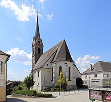
A branch church in Eggerding is said to have existed as early as 785, and in 1190 "Eckharding" was mentioned for the first time in a document. Castle and Hofmark in Hackledt were the ancestral seat of the family of the same name , which resided here continuously from their first appearance in 1377 until the end of the 18th century. In the sources it is never referred to as anything other than the free property of this family. The village of Hackledt was first mentioned in a document in 1396 in an arbitration judgment. Until 1779 the places were Bavarian and came after the peace of Teschen with the Innviertel (at that time 'Innbaiern') to Austria . In 1785 Eggerding was raised to parish. During the Napoleonic Wars briefly Bavarian again, the places finally belonged to Upper Austria since 1814.
After the annexation of Austria to the German Reich on March 13, 1938, the place belonged to the Gau Oberdonau . After 1945 the restoration of Upper Austria took place.
coat of arms
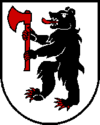
Blazon : In silver, a black, erect bear with a red tongue and red claws, which holds a red hoe in its front paws. The community colors are yellow-red-white. The bear comes from the family coat of arms of the Hackledter , who lived at Hackledt Castle in the municipality of Eggerding.
politics
The municipal council has a total of 19 members. With the municipal council and mayoral elections in Upper Austria in 2015 , the municipal council has the following distribution: 11 ÖVP, 6 FPÖ and 2 SPÖ.
- mayor
- since 1991 Johann Hingsamer (ÖVP)
Culture and sights
- Musikverein Eggerding
- Eggerdinger mini orchestra
Web links
- Private website about the community
- Map in the Digital Upper Austrian Room Information System ( DORIS )
- More information about the municipality of Eggerding on the geographic information system of the federal state of Upper Austria .
Individual evidence
- ↑ Statistics Austria: Population on January 1st, 2020 by locality (area status on January 1st, 2020) , ( CSV )
- ↑ Statistics Austria, A look at the community Eggerding, population development. Retrieved April 15, 2019 .
- ^ State of Upper Austria, history and geography, coat of arms. Retrieved April 15, 2019 .
- ^ Province of Upper Austria, results of the 2015 elections. Retrieved on April 15, 2019 .


