
Malching
| coat of arms | Germany map | |
|---|---|---|

|
Coordinates: 48 ° 19 ' N , 13 ° 11' E |
|
| Basic data | ||
| State : | Bavaria | |
| Administrative region : | Lower Bavaria | |
| County : | Passau | |
| Management Community : | Rotthalmünster | |
| Height : | 345 m above sea level NHN | |
| Area : | 25.24 km 2 | |
| Residents: | 1282 (Dec. 31, 2019) | |
| Population density : | 51 inhabitants per km 2 | |
| Postal code : | 94094 | |
| Area code : | 08573 | |
| License plate : | PA | |
| Community key : | 09 2 75 132 | |
| Community structure: | 52 districts | |
| Address of the municipal administration: |
Hauptstrasse 15 94094 Malching |
|
| Website : | ||
| Mayor : | Georg Hofer ( CSU ) | |
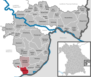
| Location of the municipality of Malching in the district of Passau | ||
  |
||


Malching is a municipality in the Lower Bavarian district of Passau and a member of the Rotthalmünster administrative community .
geography
Geographical location
Malching is located in the Danube Forest region directly on the Inn and forms the southernmost municipality in the Passau district . It borders on the Rottal-Inn district and the Braunau district on the Austrian side of the border river. Malching is located around 35 km south of Passau , 25 km from Schärding , 12 km from Pocking and Simbach am Inn and 135 km from Munich .
Neighboring communities
- Ering (Rottal-Inn district)
- Koesslarn
- Rotthalmünster
- Kirchham
- Bad Ditzenbach
Community structure
The municipality of Malching has 52 districts:
There is only the district of Malching.
history
Until the church is planted
Malching was first mentioned in a document between 748 and 788. The place was part of the Duchy of Bavaria and formed a closed Hofmark in the Middle Ages , which had belonged to the Fronhamers since at least 1448 and to the Counts of Paumgarten from 1618 . In 1734, the property of Malching's greatest landlord, the cathedral chapter of Freising, was sold to the Paumgartner family. In the course of the administrative reforms in Bavaria , today's municipality was created with the municipal edict of 1818 .
19th and 20th centuries
In the revolutionary year of 1848 , the remnants of the Paumgartner mansion were eliminated. The opening of a railway line through Malching took place in 1910. The closure of the station on May 31, 1969 hit the place hard. In 1978, Malching became part of the Rotthalmünster administrative community and the municipality's administration, with the exception of a branch, was relocated to Rotthalmünster.
Population development
Between 1988 and 2018 the municipality grew from 1,119 to 1,289 by 170 inhabitants or 15.2%.
- 1961: 1257 inhabitants
- 1970: 1252 inhabitants
- 1987: 1154 inhabitants
- 1991: 1148 inhabitants
- 1995: 1178 inhabitants
- 2000: 1252 inhabitants
- 2005: 1304 inhabitants
- 2010: 1292 inhabitants
- 2015: 1247 inhabitants
- 2018: 1289 inhabitants
politics
Municipal council
In the local elections on March 15, 2020, 690 of the 1,095 residents in the municipality of Malching exercised their right to vote, bringing the turnout to 63.01%.
mayor
- –2008: Paul Reithmeier (Free Voters' Association)
- 2008– : Georg Hofer (CSU)
In the local elections on March 15, 2020, Georg Hofer ( CSU ) was elected for a third term with 93.55% of the vote.
coat of arms
The design of the coat of arms of Malching refers to the powerful family of the imperial counts of Paumgarten zu Ering and Frauenstein , who ruled Malching for centuries.
Architectural monuments
Economy and Infrastructure
Economy including agriculture and forestry
In 2017 there were 109 jobs subject to social security contributions in the municipality. Of the resident population, 436 people were in an employment relationship subject to compulsory insurance. This means that the number of out-commuters was 327 more than that of in-commuters. 14 residents were unemployed. In 2016 there were 38 farms; 1532 hectares of the parish area were used for agriculture.
traffic
The A 94 leads through the municipality , to which Malching is connected by junction 30 (Malching). State road 2116 also runs through the municipality . Malching was also on the Simbach – Pocking railway line and had a train station that was operated by passengers until 1969. This route has now been dismantled and converted into a cycle path.
education
There are the following institutions (as of 2018):
- a day-care center with 40 approved kindergarten places and 37 children
Individual evidence
- ↑ "Data 2" sheet, Statistical Report A1200C 202041 Population of the municipalities, districts and administrative districts 1st quarter 2020 (population based on the 2011 census) ( help ).
- ↑ Malching municipality in the local database of the Bavarian State Library Online . Bayerische Staatsbibliothek, accessed on August 20, 2018.
- ↑ a b Municipal council election 2020
- ↑ Mayoral election 2020
Web links
- Entry on the coat of arms of Malching in the database of the House of Bavarian History
Aicha in front of the forest | Aidenbach | Aldersbach | Bad Füssing | Bad Griesbach im Rottal | Beutelsbach | Breitenberg | Büchlberg | Eging am See | Fürstenstein | Fürstenzell | Haarbach | Hauzenberg | Hofkirchen | Hutthurm | Kirchham | Kößlarn | Malching | Neuburg am Inn | Neuhaus am Inn | Neukirchen vorm Wald | Obernzell | Ortenburg | Pocking | Rotthalmünster | Rowing | Ruhstorf an der Rott | Salt Trail | Suns | Tettenweis | Thyrnau | Tiefenbach | Tittling | Untergriesbach | Vilshofen on the Danube | Wegscheid | Windorf | Witzmannsberg