
Aldersbach
| coat of arms | Germany map | |
|---|---|---|

|
Coordinates: 48 ° 35 ' N , 13 ° 5' E |
|
| Basic data | ||
| State : | Bavaria | |
| Administrative region : | Lower Bavaria | |
| County : | Passau | |
| Height : | 328 m above sea level NHN | |
| Area : | 45.82 km 2 | |
| Residents: | 4330 (Dec. 31, 2019) | |
| Population density : | 95 inhabitants per km 2 | |
| Postal code : | 94501 | |
| Area code : | 08543 | |
| License plate : | PA | |
| Community key : | 09 2 75 114 | |
| LOCODE : | DE ALX | |
| Community structure: | 52 districts | |
| Address of the municipal administration: |
Community of Aldersbach Klosterplatz 1 94501 Aldersbach |
|
| Website : | ||
| Mayor : | Harald Mayrhofer ( CSU / non-partisan voters ) | |
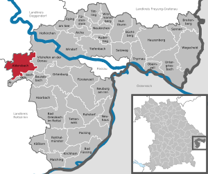
| Location of the municipality of Aldersbach in the district of Passau | ||
  |
||


Aldersbach is a municipality in the Lower Bavarian district of Passau . The place is known, among other things, for the Aldersbach monastery and the state exhibition "Beer in Bavaria" 2016 .
geography
Geographical location
The community is located in the Danube Forest region in the Vils valley, around ten kilometers southwest of Vilshofen an der Donau , 30 km west of Passau , 25 km north of Pfarrkirchen and 15 km south of Osterhofen . The Aldersbach stream runs through the village . The area between Aldersbach and Fürstenzell is mainly known from a tourist point of view as the Klosterwinkel .
Community structure
The municipality has 52 parts:
There are the districts of Pörndorf, Walchsing, Aldersbach and Haidenburg.
Neighboring places
- Johanniskirchen ( Rottal-Inn district )
- Roßbach (Rottal-Inn district)
- Osterhofen ( district of Deggendorf )
- Künzing (District Deggendorf)
- Vilshofen an der Donau (District of Passau)
- Aidenbach (District of Passau)
history
Until the church is planted
The first historical mention of a settlement with the name Aldarespah comes from the middle of the 8th century in the traditional codex of the Mondsee Monastery . The alleged first mention of a church in Aldersbach from this period is based on a misunderstood note from the early 14th century, which has been handed down in the oldest account book of the Aldersbach monastery. In 1120 the first monastery in Aldersbach ( St. Peter ) was founded by Augustinian canons. The name Alderbach was already in use around 1140, a Latinized form can be found in written documents from the early 16th century as Adalogeriopagus. The name is derived from the personal name Althar or Aldar and the Old High German pah or pach for a stream.
Aldersbach belonged to the Landshut Rent Office and the Vilshofen Regional Court of the Electorate of Bavaria . The Aldersbach Abbey owned an open Hofmark here , which was secularized in 1803 . In 1806 the churches in Weng and on the Bernhardsberg were sold and demolished. In the course of the administrative reforms in Bavaria , the municipality of Aldersbach was created with the municipal edict of 1818 .
Administrative community
The forced membership in the administrative community Aidenbach was lifted in 1980.
History of the districts
The place Walchsing was first mentioned in a document in 1100. Haidenburg was an aristocratic seat that originally belonged to the Harbach lordship, was acquired by the Aldersbach monastery in 1737 and was bought by Johann Adam Freiherr von Aretin after the secularization in 1811 . As a result of the reforms in Bavaria, the municipal edict of 1818 created the former municipalities of Pörndorf, Haidenburg and Walchsing, which were incorporated into Aldersbach in 1972.
Incorporations
On January 1, 1972, the previously independent community of Walchsing and the districts of Eggerting , Freundorf , Galgenberg , Haidenburg , Hinteröd and Uttigkofen were incorporated into the dissolved community of Haidenburg. On July 1, 1972, Pörndorf ( district of Eggenfelden ) was added.
Population development
In the period from 1988 to 2018, the municipality grew from 3,607 to 4,273 by 666 inhabitants or 18.5%.
- 1961: 3304 inhabitants
- 1970: 3210 inhabitants
- 1987: 3574 inhabitants
- 1991: 3801 inhabitants
- 1995: 3885 inhabitants
- 2000: 4018 inhabitants
- 2005: 4310 inhabitants
- 2010: 4,300 inhabitants
- 2015: 4224 inhabitants
politics
Municipal council
The local elections of 2020 and earlier resulted in the following allocation of seats:
| CSU | Free voters | Green | SPD - PWG | total | |
| 2020 | 7th | 4th | 3 | 2 | 16 |
| 2014 | 8th | 3 | 3 | 2 | 16 |
mayor
Mayor is Harald Mayrhofer (CSU / non-partisan voters).
A special feature in Aldersbach is the political stability, so that the municipality had only three mayors since 1946: Alfons Duschl held this office from 1946 to 1966, followed by Josef Kiermeier until 1990. Franz Schwarz was mayor from 1990 to 2014. In the local elections on March 16, 2014, Harald Mayrhofer was re-elected for 6 years. Mayerhofer was confirmed in office with 54.95 percent in the local elections on March 15, 2020 .
Architectural monuments
- Former Cistercian monastery in Aldersbach
- Parish Church of St. Michael in Walchsing
Economy and Infrastructure
Economy including agriculture and forestry

In 2017 there were 1,867 jobs subject to social security contributions in the municipality. Of the resident population, 1,725 people were in an employment relationship subject to compulsory insurance. The number of in-commuters was 142 more than that of out-commuters. 60 residents were unemployed. In 2016 there were 65 farms. 3,271 hectares of the community area were used for agriculture.
The largest employer in the municipality is the KNORR-Bremse AG plant , which employs almost 1,000 people. Another major employer is the Aldersbach brewery .
education
The following institutions exist as of 2018:
- two kindergartens: St. Maria, St. Wolfgang, with a total of 159 approved places and 139 children
- Wolfgang Marius Primary School Aldersbach with 16 teachers, 12 classes and 248 students
sons and daughters of the town
- Heinrich von Aretin (1875–1943), landowner and member of the Reichstag
- Franz Xaver Eggersdorfer (1879–1958), Catholic theologian and educator
- Friedrich Hofmann (1902–1977), Catholic theologian
- Fred Arbinger (* 1957), soccer player and coach
literature
- Bernhard Lübbers : Art. Aldersbach. In: Hans-Michael Körner , Alois Schmid (ed.), Martin Ott: Handbook of historical sites . Volume 7: Bavaria I. Part 1: Old Bavaria and Swabia (= Kröner's pocket edition . Volume 324). Kröner, Stuttgart 2006, ISBN 3-520-32401-6 , pp. 10-11.
Web links
- Homepage
- Haidenburg Castle
- Aldersbach: Official statistics of the LfStat (PDF; 1.24 MB)
- Entry on the coat of arms of Aldersbach in the database of the House of Bavarian History
Individual evidence
- ↑ "Data 2" sheet, Statistical Report A1200C 202041 Population of the municipalities, districts and administrative districts 1st quarter 2020 (population based on the 2011 census) ( help ).
- ↑ Aldersbach municipal administration: Community> Town Hall> Mayor. Retrieved May 10, 2020 .
- ^ Community of Aldersbach in the local database of the Bavarian State Library Online . Bayerische Staatsbibliothek, accessed on August 20, 2018.
- ↑ Bavarian State Office for Statistics and Data Processing (Hrsg.): The municipalities of Bavaria according to the territorial status May 25, 1987. The population of the municipalities of Bavaria and the changes in the acquisitions and territory from 1840 to 1987 (= contributions to Statistics Bavaria . Issue 451). Munich 1991, p. 66 , urn : nbn: de: bvb: 12-bsb00070717-7 ( digitized version - footnote 3).
- ^ Wilhelm Volkert (ed.): Handbook of Bavarian offices, communities and courts 1799–1980 . CH Beck, Munich 1983, ISBN 3-406-09669-7 , p. 586 .
- ↑ a b c Local council election & mayoral election in Aldersbach 2020 - Candidates & results werk = wahl.info. March 16, 2020, accessed May 24, 2020 .
Aicha in front of the forest | Aidenbach | Aldersbach | Bad Füssing | Bad Griesbach im Rottal | Beutelsbach | Breitenberg | Büchlberg | Eging am See | Fürstenstein | Fürstenzell | Haarbach | Hauzenberg | Hofkirchen | Hutthurm | Kirchham | Kößlarn | Malching | Neuburg am Inn | Neuhaus am Inn | Neukirchen vorm Wald | Obernzell | Ortenburg | Pocking | Rotthalmünster | Rowing | Ruhstorf an der Rott | Salt Trail | Suns | Tettenweis | Thyrnau | Tiefenbach | Tittling | Untergriesbach | Vilshofen on the Danube | Wegscheid | Windorf | Witzmannsberg
Adenberg | Aldersbach | At the Käserberg | Ammerreuth | Atzenberg | Beiglöd | Shower dump | Corner | Edelsbrunn | Eggerting | Freundorf | Gainstorf | Gallows Mountain | Grüneröd | Gumperting | Hague | Haidach | Haideck | Haidenburg | Harreröd | Heinrichsdorf | Hiendlöd | Hinteröd | Shepherd | Holzhausen | Wooden houses | Hütter | Karglöd | Kramersepp | Kriestorf | Maierhof | Meiering | Moss | Neustift | Niederöd | Oilate | Pörndorf | Riding | Reuth | Röslöd | Saint Peter | Schwaig | Blackwood | Be | Stocköd | Uttigkofen | Vogler | Walchsing | Weidfeld | Weng | Whetstone | Wifling