
Eggenfelden district
| coat of arms | Germany map | |
|---|---|---|

|
Coordinates: 48 ° 24 ' N , 12 ° 46' E |
|
| Basic data (as of 1972) | ||
| Existing period: | 1862-1972 | |
| State : | Bavaria | |
| Administrative region : | Lower Bavaria | |
| Administrative headquarters : | Eggenfelden | |
| Area : | 661 km 2 | |
| Residents: | 48,600 (Dec. 31, 1971) | |
| Population density : | 74 inhabitants per km 2 | |
| License plate : | EG | |
| Circle key : | 09 2 34 | |
| Circle structure: | 62 parishes | |
| Address of the district administration: |
8330 Eggenfelden | |
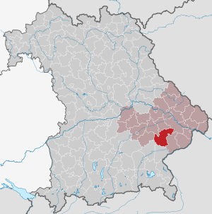
| Location of the Eggenfelden district in Bavaria | ||
  |
||

The district of Eggenfelden belonged to the Bavarian administrative district of Niederbayern . Most of its former area is now part of the Rottal-Inn district .
geography
Important places
The most populous places were Eggenfelden , Arnstorf , Gangkofen and Massing .
Neighboring areas
In 1972 the district bordered in a clockwise direction in the northwest on the districts of Dingolfing , Landau an der Isar , Vilshofen , Pfarrkirchen , Altötting , Mühldorf am Inn and Vilsbiburg .
history
district Court
In 1803 the Eggenfelden district court was established in the course of the administrative restructuring of Bavaria . After the establishment of the Kingdom of Bavaria, this was added to the Lower Danube District, whose capital was Passau.
In 1838 the Lower Danube District was renamed the District of Lower Bavaria , from which the administrative district of the same name emerged . The district capital was moved to Landshut .
District Office
The District Office Eggenfelden was formed in 1862 through the merger of the regional courts of the older order Arnstorf and Eggenfelden, with the Arnstorf regional court only being rebuilt in 1861 from communities of the regional courts Eggenfelden, Landau an der Isar and parish churches.
district
On January 1, 1939, the uniform designation Landkreis was introduced in the German Reich . So the district office became the Eggenfelden district.
On July 1, 1972, the Eggenfelden district was divided up in the course of the regional reform in Bavaria . The Simbach market as well as the communities Langgraben, Pischelsdorf and Ruhstorf came to the Untere Isar district , which was renamed the Dingolfing-Landau district on May 1, 1973 . The municipality of Pörndorf came to the district of Passau .
All other communities were combined with the district of Pfarrkirchen and two communities each from the former districts of Griesbach im Rottal and Vilsbiburg to form the new district of Rottal . On May 1, 1973 it was given its current name Rottal-Inn district .
Population development
| year | Residents | source |
|---|---|---|
| 1864 | 31,175 | |
| 1885 | 35,213 | |
| 1900 | 36,392 | |
| 1910 | 39,936 | |
| 1925 | 41,776 | |
| 1939 | 41,635 | |
| 1950 | 57,691 | |
| 1960 | 47,700 | |
| 1971 | 48,600 |
Communities
Before the beginning of the Bavarian regional reform, the Eggenfelden district comprised 62 communities in the 1960s:
|
|
- Incorporation and renaming until 1952
- The community Diepoltskirchen I was renamed Diepoltskirchen in 1952 .
- The community of Diepoltskirchen II was renamed Oberhöft in 1952 .
- The Peterskirchen I community was renamed Peterskirchen in 1952 .
- The Peterskirchen II community was renamed Unterzeitlarn in 1952 .
- The Eggersdorf community was incorporated into Emmersdorf on January 1, 1946.
- The community of Dummeldorf was incorporated into Johanniskirchen on January 1, 1946.
License Plate
On July 1, 1956, the district was assigned the distinguishing mark EC when the vehicle registration number that is still valid today was introduced . It was issued until August 3, 1974. It has been available again in the Rottal-Inn district since July 10, 2013 .
literature
- Josef Kalmer (Ed.): The district of Eggenfelden. 1946-1951. A report on developments in the Eggenfelden district over the past 5 years . District Office Eggenfelden, Eggenfelden 1952
Individual evidence
- ^ Wilhelm Volkert (ed.): Handbook of Bavarian offices, communities and courts 1799–1980 . CH Beck, Munich 1983, ISBN 3-406-09669-7 , p. 434 .
- ^ Wilhelm Volkert (ed.): Handbook of Bavarian offices, communities and courts 1799–1980 . CH Beck, Munich 1983, ISBN 3-406-09669-7 , p. 97 .
- ^ Federal Statistical Office (ed.): Historical municipality directory for the Federal Republic of Germany. Name, border and key number changes in municipalities, counties and administrative districts from May 27, 1970 to December 31, 1982 . W. Kohlhammer, Stuttgart / Mainz 1983, ISBN 3-17-003263-1 , p. 607 f., 629 and 634 .
- ^ Ordinance on the reorganization of Bavaria into rural districts and independent cities of December 27, 1971
- ^ Eugen Hartmann: Statistics of the Kingdom of Bavaria . Ed .: Royal Bavarian Statistical Bureau. Munich 1866, population figures of the district offices 1864 ( digitized version ).
- ↑ Royal Bavarian Statistical Bureau (ed.): Localities directory of the Kingdom of Bavaria . Munich 1888, population figures of the district offices 1885 ( digitized ).
- ↑ a b www.gemeindeververzeichnis.de
- ^ Localities directory for the Free State of Bavaria, based on the census of June 16, 1925
- ↑ Statistical Yearbook for the German Reich 1940
- ↑ Statistical Yearbook for the Federal Republic of Germany 1952
- ↑ Statistical Yearbook for the Federal Republic of Germany 1961
- ↑ Statistical Yearbook for the Federal Republic of Germany 1973
- ^ Official register of places for Bavaria 1964
Web links
- http://cms.rottal-inn.de/Landkreis/Landkreisportraet.aspx
- Michael Rademacher: German administrative history from the unification of the empire in 1871 to the reunification in 1990. Eggenfelden district. (Online material for the dissertation, Osnabrück 2006).
Aichach | Alzenau i.UFr. | Amberg | Bad Aibling | Bad Neustadt adSaale | Bad Toelz | Beilngries | Berchtesgaden | Bow | Brückenau | Burglengenfeld | Dingolfing | Dinkelsbühl | Donauwörth | Ebermannstadt | Boars | Eggenfelden | Erlangen | Eschenbach idOPf. | Feuchtwangen | Friedberg | Feet | Gemünden a.Main | Gerolzhofen | Grafenau | Griesbach i.Rottal | Gunzenhausen | Hammelburg | Hassfurt | Hersbruck | Hilpoltstein | Höchstadt adAisch | Hofheim i.UFr. | Illertissen | Ingolstadt | Karlstadt | Kaufbeuren | Kemnath | Kempten (Allgäu) | Königshofen i.Grabfeld | Kötzting | Krumbach (Swabia) | Landau adIsar | Lauf adPegnitz | Running | Lohr a.Main | Mainburg | Mallersdorf | Marktheidenfeld | Marktoberdorf | Mellrichstadt | Memmingen | Mindelheim | Münchberg | Nabburg | Naila | Neuburg adDonau | Neunburg vorm Wald | Neustadt adAisch | Nordlingen | Nuremberg | Obernburg am Main | Oberviechtach | Ochsenfurt | Parsberg | Pegnitz | Parish churches | Rehau | Riedenburg | Roding | Rothenburg ob der Tauber | Rottenburg adLaaber | Scheinfeld | Schongau | Schrobenhausen | Schwabach | Schwabmünchen | Sonthofen | Stadtsteinach | Staffelstein | Straubing | Sulzbach-Rosenberg | Uffenheim | Viechtach | Vilsbiburg | Vilshofen | Vohenstrauss | Waldmünchen | Wasserburg a.Inn | Wegscheid | Weilheim i.OB | Weißenburg i.Bay. | Wertingen | Wolfratshausen | Wolfstein
1939–1945 affiliated districts: Bergreichenstein | Eisenstein market | Prachatitz