
Schrobenhausen district
| coat of arms | Germany map | |
|---|---|---|

|
Coordinates: 48 ° 34 ' N , 11 ° 16' E |
|
| Basic data (as of 1972) | ||
| State : | Bavaria | |
| Administrative region : | Upper Bavaria | |
| Administrative headquarters : | Schrobenhausen | |
| Area : | 394.54 km 2 | |
| Residents: | 31,340 (May 27, 1970) | |
| Population density : | 79 inhabitants per km 2 | |
| License plate : | SOB | |
| Circle key : | 09 1 51 | |
| Circle structure: | 38 parishes | |
| District Administrator : | Walter Asam | |
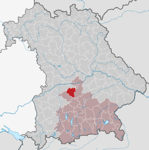
| Location of the district of Schrobenhausen in Bavaria | ||
  |
||

The district of Schrobenhausen belonged to the Bavarian administrative district of Upper Bavaria . It existed until the territorial reform in 1972. Its former area is now mainly in the districts of Neuburg-Schrobenhausen and Pfaffenhofen an der Ilm .
geography
Important places
The most populous places were the district town of Schrobenhausen as well as Hohenwart , Langenmosen and Berg im Gau .
Neighboring areas
Starting in 1972, the district bordered clockwise in the north on the districts of Neuburg an der Donau , Ingolstadt , Pfaffenhofen an der Ilm and Aichach .
history
District Office
The district office of Schrobenhausen followed in 1862 the area court of the older order of Schrobenhausen.
On August 1, 1927, the municipality of Volkersdorf moved to the Pfaffenhofen an der Ilm district office .
district
On January 1, 1939, the designation district was introduced as everywhere else in the German Reich . So the district office became the district of Schrobenhausen.
On July 1, 1972, the district of Schrobenhausen was dissolved as part of the regional reform in Bavaria :
- The community of Grimolzhausen came to the district of Aichach-Friedberg .
- The municipalities Alber cell , free Hausen , Gerolsbach , Hirschhausen , Hohenwart , Klenau , Klosterberg , Koppenbach , Seibersdorf , singing Bach , Strobenried and turnout Ried were the district Pfaffenhofen slammed shut.
- All other municipalities were combined with the eastern part of the district of Neuburg an der Donau and the previously independent city of Neuburg an der Donau to form the new district of Neuburg an der Donau . The district was renamed the Neuburg-Schrobenhausen district on May 1, 1973 .
Population development
| year | Residents | source |
|---|---|---|
| 1864 | 18,058 | |
| 1885 | 19,686 | |
| 1900 | 19,912 | |
| 1910 | 21,728 | |
| 1925 | 22,415 | |
| 1939 | 22,652 | |
| 1950 | 32,915 | |
| 1960 | 28,700 | |
| 1971 | 31,600 |
politics
District officials
- 1862-1865: Alois Allioli
- 1865–1876: Franz von Tautphöus
- 1876–1878: Andreas Weckerle
- 1878–1893: Cajetan Kaiser
- 1893-1896: Lorenz Gaggell
- 1896–1899: Hermann Reus
- 1899–1911: Adalbert Dilg
- 1911–1919: Ernst Luthart
- 1919–1936: Emil Schneider
- 1936–1938: Michael Fellner
- 1938–1939: Heinrich Doering (District Administrator until December 1, 1938)
District administrators
- Alois Allioli (1862-1865)
- Franz von Tautphöus (1865–1876)
- Andreas Weckerle (1876–1878)
- Cajetan Kaiser (1878-1893)
- Lorenz Gaggell (1893-1896)
- Hermann Reus (1896–1899)
- Adalbert Dilg (1899-1911)
- Ernst Luthart (1911-1919)
- Emil Schneider (1919–1936)
- Michael Fellner (1936–1938)
- 1938–1939: Heinz Doering (District Administrator from January 1, 1939)
- 1939–1945: Andreas Jäger
- 1945: Fritz Stocker
- 1945–1946: Philipp Kitzinger
- 1946–1961: Franz Gunderlach
- 1961–1972: Walter Asam
Communities
The churches that still exist today are in bold .
License Plate
On July 1, 1956, the district was assigned the distinctive sign SOB when the vehicle registration number that is still valid today was introduced . It was issued until August 3, 1974. It has been available again in the Neuburg-Schrobenhausen district since July 10, 2013 .
Individual evidence
- ^ Wilhelm Volkert (ed.): Handbook of Bavarian offices, communities and courts 1799–1980 . CH Beck, Munich 1983, ISBN 3-406-09669-7 , p. 566 .
- ^ Wilhelm Volkert (ed.): Handbook of Bavarian offices, communities and courts 1799–1980 . CH Beck, Munich 1983, ISBN 3-406-09669-7 , p. 97 .
- ^ Federal Statistical Office (ed.): Historical municipality directory for the Federal Republic of Germany. Name, border and key number changes in municipalities, counties and administrative districts from May 27, 1970 to December 31, 1982 . W. Kohlhammer, Stuttgart / Mainz 1983, ISBN 3-17-003263-1 , p. 590 .
- ^ Ordinance on the reorganization of Bavaria into rural districts and independent cities of December 27, 1971
- ^ Federal Statistical Office (ed.): Historical municipality directory for the Federal Republic of Germany. Name, border and key number changes in municipalities, counties and administrative districts from May 27, 1970 to December 31, 1982 . W. Kohlhammer, Stuttgart / Mainz 1983, ISBN 3-17-003263-1 , p. 601 .
- ^ Eugen Hartmann: Statistics of the Kingdom of Bavaria . Ed .: Royal Bavarian Statistical Bureau. Munich 1866, population figures of the district offices 1864 ( digitized version ).
- ↑ Royal Bavarian Statistical Bureau (ed.): Localities directory of the Kingdom of Bavaria . Munich 1888, population figures of the district offices 1885 ( digitized ).
- ↑ a b www.gemeindeververzeichnis.de
- ^ Localities directory for the Free State of Bavaria, based on the census of June 16, 1925
- ↑ Statistical Yearbook for the German Reich 1940
- ↑ Statistical Yearbook for the Federal Republic of Germany 1952
- ↑ Statistical Yearbook for the Federal Republic of Germany 1961
- ↑ Statistical Yearbook for the Federal Republic of Germany 1973
Web links
- District of Neuburg Schrobenhausen - history
- Michael Rademacher: German administrative history from the unification of the empire in 1871 to the reunification in 1990. Schrobenhausen district. (Online material for the dissertation, Osnabrück 2006).
literature
- Friedrich Hilble, Cornelia Baumann-Oelwein: District of Schrobenhausen (= Historical Place Name Book of Bavaria. Upper Bavaria. Vol. 5). Commission for Bavarian State History, Munich 1996, ISBN 3-7696-9694-8 .
Aichach | Alzenau i.UFr. | Amberg | Bad Aibling | Bad Neustadt adSaale | Bad Toelz | Beilngries | Berchtesgaden | Bow | Brückenau | Burglengenfeld | Dingolfing | Dinkelsbühl | Donauwörth | Ebermannstadt | Boars | Eggenfelden | Erlangen | Eschenbach idOPf. | Feuchtwangen | Friedberg | Feet | Gemünden a.Main | Gerolzhofen | Grafenau | Griesbach i.Rottal | Gunzenhausen | Hammelburg | Hassfurt | Hersbruck | Hilpoltstein | Höchstadt adAisch | Hofheim i.UFr. | Illertissen | Ingolstadt | Karlstadt | Kaufbeuren | Kemnath | Kempten (Allgäu) | Königshofen i.Grabfeld | Kötzting | Krumbach (Swabia) | Landau adIsar | Lauf adPegnitz | Running | Lohr a.Main | Mainburg | Mallersdorf | Marktheidenfeld | Marktoberdorf | Mellrichstadt | Memmingen | Mindelheim | Münchberg | Nabburg | Naila | Neuburg adDonau | Neunburg vorm Wald | Neustadt adAisch | Nordlingen | Nuremberg | Obernburg am Main | Oberviechtach | Ochsenfurt | Parsberg | Pegnitz | Parish churches | Rehau | Riedenburg | Roding | Rothenburg ob der Tauber | Rottenburg adLaaber | Scheinfeld | Schongau | Schrobenhausen | Schwabach | Schwabmünchen | Sonthofen | Stadtsteinach | Staffelstein | Straubing | Sulzbach-Rosenberg | Uffenheim | Viechtach | Vilsbiburg | Vilshofen | Vohenstrauss | Waldmünchen | Wasserburg a.Inn | Wegscheid | Weilheim i.OB | Weißenburg i.Bay. | Wertingen | Wolfratshausen | Wolfstein
1939–1945 affiliated districts: Bergreichenstein | Eisenstein market | Prachatitz