
Bad Neustadt an der Saale district
| coat of arms | Germany map | |
|---|---|---|

|
Coordinates: 50 ° 19 ′ N , 10 ° 13 ′ E |
|
| Basic data (as of 1972) | ||
| Existing period: | 1862-1972 | |
| State : | Bavaria | |
| Administrative region : | Lower Franconia | |
| Administrative headquarters : | Bad Neustadt an der Saale | |
| Area : | 367.83 km 2 | |
| Residents: | 36,100 (Dec. 31, 1971) | |
| Population density : | 98 inhabitants per km 2 | |
| License plate : | NES | |
| Circle key : | 09 6 34 | |
| Circle structure: | 39 municipalities | |
| Address of the district administration: |
8740 Bad Neustadt | |
| District Administrator : | Gottfried Miller ( CSU ) | |
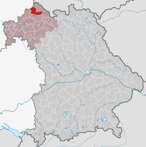
| Location of the district of Neustadt adSaale in Bavaria | ||
  |
||

The district of Bad Neustadt an der Saale , officially the district of Bad Neustadt adSaale , belonged to the Bavarian administrative district of Lower Franconia . Before the beginning of the Bavarian territorial reform in the early 1970s, the district had 39 communities.
geography
Important places
The largest towns in the district were Bad Neustadt an der Saale , Bischofsheim an der Rhön and Oberelsbach .
Neighboring areas
At the beginning of 1972 the district bordered in a clockwise direction in the northwest with the district of Fulda (in Hesse ) and the districts of Mellrichstadt , Königshofen im Grabfeld , Bad Kissingen and Brückenau or Bad Brückenau (all in Bavaria).
history
District Office
The district office Neustadt an der Saale was formed in 1862 through the merger of the regional courts of the older order Neustadt an der Saale and Bischofsheim .
The Neustadt an der Saale district office was officially renamed the Bad Neustadt an der Saale district office on July 1, 1934 .
district
On January 1, 1939, as everywhere in the German Reich, the designation district was introduced. The district office became the Bad Neustadt an der Saale district.
1 July 1972 the district Bad Neustadt an der Saale in the wake of were municipal reform in Bavaria , the counties Königshofen in the grave box and Mellrichstadt and the local radiation of the district Bad Kissingen affiliated. On May 1, 1973, the new district was given its current designation as the district of Rhön-Grabfeld .
Population development
| year | Residents | source |
|---|---|---|
| 1864 | 21,179 | |
| 1885 | 20,810 | |
| 1900 | 20,022 | |
| 1910 | 20,584 | |
| 1925 | 21,192 | |
| 1939 | 24,049 | |
| 1950 | 32,744 | |
| 1960 | 33,300 | |
| 1971 | 36,100 |
District administrators
- 19 ?? - 1963 Albert Miller
- 1963–1972 Gottfried Miller ( CSU )
Communities
Until the beginning of the Bavarian regional reform, 39 municipalities belonged to the district:
The municipality of Bad Neuhaus was incorporated into the city of Neustadt an der Saale on July 1, 1934, which took over the suffix "Bad".
License Plate
On July 1, 1956, the district was assigned the distinctive sign NES when the license plates that are still valid today were introduced . It is still issued in the Rhön-Grabfeld district to this day.
Individual evidence
- ^ Official register of places for Bavaria 1964
- ^ Wilhelm Volkert (ed.): Handbook of Bavarian offices, communities and courts 1799–1980 . CH Beck, Munich 1983, ISBN 3-406-09669-7 , p. 427 .
- ^ Wilhelm Volkert (ed.): Handbook of Bavarian offices, communities and courts 1799–1980 . CH Beck, Munich 1983, ISBN 3-406-09669-7 , p. 97 .
- ^ Federal Statistical Office (ed.): Historical municipality directory for the Federal Republic of Germany. Name, border and key number changes in municipalities, counties and administrative districts from May 27, 1970 to December 31, 1982 . W. Kohlhammer, Stuttgart / Mainz 1983, ISBN 3-17-003263-1 , p. 739 f .
- ^ Eugen Hartmann: Statistics of the Kingdom of Bavaria . Ed .: Royal Bavarian Statistical Bureau. Munich 1866, population of the district offices 1864, p. 106 ( digitized version ).
- ↑ Royal Bavarian Statistical Bureau (ed.): Localities directory of the Kingdom of Bavaria . Munich 1888, population figures of the district offices 1885 ( digitized ).
- ↑ a b www.gemeindeververzeichnis.de: Lower Franconia
- ↑ for the Free State of Bavaria, according to the census of June 16, 1925
- ↑ Statistical Yearbook for the German Reich 1940
- ↑ Statistical Yearbook for the Federal Republic of Germany 1952
- ↑ Statistical Yearbook for the Federal Republic of Germany 1961
- ↑ Statistical Yearbook for the Federal Republic of Germany 1973
Aichach | Alzenau i.UFr. | Amberg | Bad Aibling | Bad Neustadt adSaale | Bad Toelz | Beilngries | Berchtesgaden | Bow | Brückenau | Burglengenfeld | Dingolfing | Dinkelsbühl | Donauwörth | Ebermannstadt | Boars | Eggenfelden | Erlangen | Eschenbach idOPf. | Feuchtwangen | Friedberg | Feet | Gemünden a.Main | Gerolzhofen | Grafenau | Griesbach i.Rottal | Gunzenhausen | Hammelburg | Hassfurt | Hersbruck | Hilpoltstein | Höchstadt adAisch | Hofheim i.UFr. | Illertissen | Ingolstadt | Karlstadt | Kaufbeuren | Kemnath | Kempten (Allgäu) | Königshofen i.Grabfeld | Kötzting | Krumbach (Swabia) | Landau adIsar | Lauf adPegnitz | Running | Lohr a.Main | Mainburg | Mallersdorf | Marktheidenfeld | Marktoberdorf | Mellrichstadt | Memmingen | Mindelheim | Münchberg | Nabburg | Naila | Neuburg adDonau | Neunburg vorm Wald | Neustadt adAisch | Nordlingen | Nuremberg | Obernburg am Main | Oberviechtach | Ochsenfurt | Parsberg | Pegnitz | Parish churches | Rehau | Riedenburg | Roding | Rothenburg ob der Tauber | Rottenburg adLaaber | Scheinfeld | Schongau | Schrobenhausen | Schwabach | Schwabmünchen | Sonthofen | Stadtsteinach | Staffelstein | Straubing | Sulzbach-Rosenberg | Uffenheim | Viechtach | Vilsbiburg | Vilshofen | Vohenstrauss | Waldmünchen | Wasserburg a.Inn | Wegscheid | Weilheim i.OB | Weißenburg i.Bay. | Wertingen | Wolfratshausen | Wolfstein
1939–1945 affiliated districts: Bergreichenstein | Eisenstein market | Prachatitz