
District of Ebermannstadt
| coat of arms | Germany map | |
|---|---|---|

|
Coordinates: 49 ° 47 ' N , 11 ° 11' E |
|
| Basic data (as of 1972) | ||
| Existing period: | 1862-1972 | |
| State : | Bavaria | |
| Administrative region : | Upper Franconia | |
| Administrative headquarters : | Ebermannstadt | |
| Area : | 429.56 km 2 | |
| Residents: | 28,200 (December 31, 1971) | |
| Population density : | 66 inhabitants per km 2 | |
| License plate : | EBS | |
| Circle key : | 09 4 34 | |
| Circle structure: | 67 parishes | |
| Address of the district administration: |
8553 Ebermannstadt | |
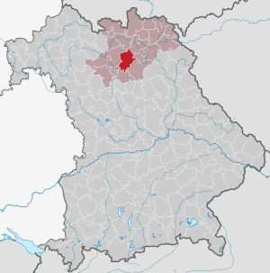
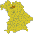
| Location of the district of Ebermannstadt in Bavaria | ||
  |
||

The district of Ebermannstadt is a former district in Bavaria and belonged to the administrative district of Upper Franconia . It was dissolved in 1972 during the territorial reform and its territory was divided into the districts of Forchheim , Bamberg and Bayreuth .
Neighboring areas
In 1972 the district bordered clockwise, beginning in the north, on the districts of Lichtenfels , Kulmbach , Bayreuth, Pegnitz , Forchheim and Bamberg.
history
District Office
The Ebermannstadt district office was formed in 1862 through the merger of the older district courts of Ebermannstadt and Hollfeld .
On the occasion of the reform of the layout of the Bavarian district offices, the Ebermannstadt district office ceded the Buckendorf community to the Lichtenfels district office on January 1, 1880 .
district
On January 1, 1939, the uniform imperial designation Landkreis was introduced. So the district office of Ebermannstadt became from the district office.
The district of Ebermannstadt was dissolved as part of the regional reform on July 1, 1972:
- The communities of Heiligenstadt in Upper Franconia and Königsfeld came to the Bamberg district .
- The cities of Hollfeld and Waischenfeld as well as the communities Aufseß , Breitenlesau , Freienfels , Hochstahl , Krögelstein, Löhlitz , Nankendorf , Neuhaus , Plankenfels , Schönfeld , Stechendorf , Treppendorf, Weiher, Wiesentfels and Wohnsgehaig came to the district of Bayreuth .
- The Wonsees market was added to the Kulmbach district.
- The city of Ebermannstadt and all other communities came to the Forchheim district .

Today's Forchheim district
Today's Bamberg district

Today's Bayreuth district

Today's district of Kulmbach


Population development
| year | Residents | source |
|---|---|---|
| 1864 | 24,122 | |
| 1885 | 24,245 | |
| 1900 | 22,145 | |
| 1910 | 22,910 | |
| 1925 | 22.805 | |
| 1939 | 21,905 | |
| 1950 | 30,264 | |
| 1960 | 25,900 | |
| 1971 | 28,200 |
Communities
Until the beginning of the regional reform in Bavaria, the district of Ebermannstadt consisted of three cities and 64 municipalities.
|
|
Other communities
|
|
License Plate
On July 1, 1956, the district was assigned the distinctive sign EBS when the vehicle registration number that is still valid today was introduced . It was issued until April 28, 1973. It has been available again in the districts of Bayreuth, Forchheim and Kulmbach since July 10, 2013 .
literature
- Dorothea Fastnacht: Former district of Ebermannstadt (= historical book of place names of Bavaria, Upper Franconia . Volume 4 ). Commission for Bavarian State History, Munich 2000, ISBN 3-7696-9701-4 .
Individual evidence
- ^ Wilhelm Volkert (ed.): Handbook of Bavarian offices, communities and courts 1799–1980 . CH Beck, Munich 1983, ISBN 3-406-09669-7 , p. 451 .
- ^ Wilhelm Volkert (ed.): Handbook of Bavarian offices, communities and courts 1799–1980 . CH Beck, Munich 1983, ISBN 3-406-09669-7 , p. 97 .
- ^ Federal Statistical Office (ed.): Historical municipality directory for the Federal Republic of Germany. Name, border and key number changes in municipalities, counties and administrative districts from May 27, 1970 to December 31, 1982 . W. Kohlhammer, Stuttgart / Mainz 1983, ISBN 3-17-003263-1 , p. 682 .
- ^ Ordinance on the reorganization of Bavaria into rural districts and independent cities of December 27, 1971
- ^ Eugen Hartmann: Statistics of the Kingdom of Bavaria . Ed .: Royal Bavarian Statistical Bureau. Munich 1866, population figures of the district offices 1864 ( digitized version ).
- ↑ Royal Bavarian Statistical Bureau (ed.): Localities directory of the Kingdom of Bavaria . Munich 1888, population figures of the district offices 1885 ( digitized ).
- ↑ a b www.gemeindeververzeichnis.de: Upper Franconia
- ^ Localities directory for the Free State of Bavaria, based on the census of June 16, 1925
- ↑ Statistical Yearbook for the German Reich 1940
- ↑ Statistical Yearbook for the Federal Republic of Germany 1952
- ↑ Statistical Yearbook for the Federal Republic of Germany 1961
- ↑ Statistical Yearbook for the Federal Republic of Germany 1973
Aichach | Alzenau i.UFr. | Amberg | Bad Aibling | Bad Neustadt adSaale | Bad Toelz | Beilngries | Berchtesgaden | Bow | Brückenau | Burglengenfeld | Dingolfing | Dinkelsbühl | Donauwörth | Ebermannstadt | Boars | Eggenfelden | Erlangen | Eschenbach idOPf. | Feuchtwangen | Friedberg | Feet | Gemünden a.Main | Gerolzhofen | Grafenau | Griesbach i.Rottal | Gunzenhausen | Hammelburg | Hassfurt | Hersbruck | Hilpoltstein | Höchstadt adAisch | Hofheim i.UFr. | Illertissen | Ingolstadt | Karlstadt | Kaufbeuren | Kemnath | Kempten (Allgäu) | Königshofen i.Grabfeld | Kötzting | Krumbach (Swabia) | Landau adIsar | Lauf adPegnitz | Running | Lohr a.Main | Mainburg | Mallersdorf | Marktheidenfeld | Marktoberdorf | Mellrichstadt | Memmingen | Mindelheim | Münchberg | Nabburg | Naila | Neuburg adDonau | Neunburg vorm Wald | Neustadt adAisch | Nordlingen | Nuremberg | Obernburg am Main | Oberviechtach | Ochsenfurt | Parsberg | Pegnitz | Parish churches | Rehau | Riedenburg | Roding | Rothenburg ob der Tauber | Rottenburg adLaaber | Scheinfeld | Schongau | Schrobenhausen | Schwabach | Schwabmünchen | Sonthofen | Stadtsteinach | Staffelstein | Straubing | Sulzbach-Rosenberg | Uffenheim | Viechtach | Vilsbiburg | Vilshofen | Vohenstrauss | Waldmünchen | Wasserburg a.Inn | Wegscheid | Weilheim i.OB | Weißenburg i.Bay. | Wertingen | Wolfratshausen | Wolfstein
1939–1945 affiliated districts: Bergreichenstein | Eisenstein market | Prachatitz