
Lichtenfels district
| coat of arms | Germany map |
|---|---|

|

Coordinates: 50 ° 7 ' N , 11 ° 7' E |
| Basic data | |
| State : | Bavaria |
| Administrative region : | Upper Franconia |
| Administrative headquarters : | Lichtenfels |
| Area : | 519.95 km 2 |
| Residents: | 66,776 (Dec. 31, 2019) |
| Population density : | 128 inhabitants per km 2 |
| License plate : | LIF, STE |
| Circle key : | 09 4 78 |
| NUTS : | DE24C |
| Circle structure: | 11 municipalities |
| Address of the district administration: |
Kronacher Strasse 28-30 96215 Lichtenfels |
| Website : | |
| District Administrator : | Christian Meißner ( CSU ) |
| Location of the district of Lichtenfels in Bavaria | |
  |
|

The district of Lichtenfels is located in the west of the administrative district of Upper Franconia in Bavaria . The district is a member of the Nuremberg Metropolitan Region .
geography
location
The district is mainly characterized by the Main and the Main Valley, which runs through the district from east to west. The most important cities in the district are located here, such as Burgkunstadt , Bad Staffelstein and the district town of Lichtenfels . Of the tributaries of the Main in the district, the Rodach , which flows from the north between Hochstadt am Main and Lichtenfels, is the largest. The foothills of the Franconian Alb with its upstream mountains extend south of the Main , including the Staffelberg near Bad Staffelstein. North of the Main are the foothills of the Itz-Baunach hill country.
Neighboring areas
The district borders clockwise, beginning in the northwest, on the districts of Coburg , Kronach , Kulmbach , Bayreuth and Bamberg .
history
Regional courts
Before 1800, today's district area belonged mainly to the Bamberg Monastery . In 1802 the area became part of Bavaria. In 1804 the regional courts of Lichtenfels and Weismain were established, which belonged to the Mainkreis, from 1817 Obermainkreis , from 1838 Upper Franconia . In 1862, the two regional courts were merged to form the Lichtenfels district office by hiving off 26 communities in the Staffelstein area . A separate district court or district office Staffelstein was established for the separated communities, in which the district court Seßlach established in 1812 as well as some communities of the district court Scheßlitz were absorbed.
District Office
The district office of Lichtenfels was formed in 1862 through the merger of the regional courts of the older order Lichtenfels and Seßlach.
On the occasion of the reform of the layout of the Bavarian district offices, the Lichtenfels district office received the municipalities of Buckendorf from the Ebermannstadt district office and Fesselsdorf from the Kulmbach district office on January 1, 1880 .
On January 1, 1927, the Lichtenfels district office handed over the communities of Hain and Wildenberg to the Kronach district office .
district
On January 1, 1939, as everywhere in the German Reich, the designation district was introduced. This is how the district office became the Lichtenfels district.
During the regional reform in Bavaria on July 1, 1972, the previous Lichtenfels district (with the exception of Burkersdorf , which was incorporated into the Küps community , Kronach district), most of the Staffelstein district and the Unterlangenstadt community of the Kronach district became today's district Lichtenfels formed. The other communities in the Staffelstein district were divided between the Bamberg and Coburg districts.
On January 1, 1975, the Coburg district ceded the Freiberg community to the Lichtenfels district. There it was incorporated into Eggenbach . On January 1, 1978, the district of Coburg was enlarged to include the community of Neuensorg in the Lichtenfels district, which was incorporated into Weidhausen near Coburg .
Population development

From 1988 to 2008, the Lichtenfels district grew by around 2800 inhabitants or around 4%. However, the trend has been declining again since 2001 after a high of around 71,000 inhabitants.
In terms of the number of inhabitants, the district of Lichtenfels is the smallest district in Bavaria with around 67,000 inhabitants.
The following figures refer to the territorial status on May 25, 1987.
| Population development | |||||||||||||||
|---|---|---|---|---|---|---|---|---|---|---|---|---|---|---|---|
| year | 1840 | 1900 | 1939 | 1950 | 1961 | 1970 | 1987 | 1991 | 1995 | 2000 | 2005 | 2010 | 2015 | 2017 | |
| Residents | 35,577 | 41,456 | 50,246 | 69,722 | 66,269 | 67,863 | 65,602 | 68.506 | 70,512 | 70,840 | 70,057 | 68,087 | 66,655 | 66,777 | |
Population development 2004–2009

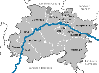
As in previous years, the Lichtenfels district constantly lost its population between 2004 and 2009. According to the State Statistical Office, the population decreased by 2057 during this period. This corresponds to a minus of 2.91%. While in the west of the district, especially in Ebensfeld , the population decline was rather low, towards the east there was a gradient in terms of population decline. In terms of percentage, the population decreased in Marktzeuln with a minus of 9.09% (163 inhabitants), and in absolute terms most in Lichtenfels with 768 inhabitants (-3.57%). Redwitz was the only municipality in the district to record a population growth of 0.88%.
| City / municipality | Sept. 30, 2004 | Sept. 30, 2009 | growth of population |
|---|---|---|---|
| Altenkunstadt | 5619 | 5417 | -3.59% |
| Bad Staffelstein | 10,684 | 10,523 | -1.50% |
| Burgkunstadt | 6969 | 6690 | -4.00% |
| Ebensfeld | 5733 | 5705 | -0.48% |
| Hochstadt am Main | 1701 | 1688 | -0.76% |
| Lichtenfels | 21,457 | 20,689 | -3.57% |
| Marktgraitz | 1375 | 1290 | -6.18% |
| Marketers | 1793 | 1630 | -9.09% |
| Michelau | 6908 | 6599 | -4.47% |
| Redwitz | 3373 | 3403 | + 0.88% |
| Weismain | 4849 | 4770 | -1.62% |
| Total: | 70,461 | 68,404 | -2.91% |
politics
District council
The district council is composed of 50 district councilors and the district administrator. In the past elections, the distribution of seats for the district councils resulted in the following:
| CSU | SPD | FW * | Green |
JW / JWU / JB ** |
Social Citizens | AfD | total | |
| 2002 | 23 | 13 | 8th | 2 | 4th | - | - | 50 seats |
| 2008 | 23 | 11 | 8th | 3 | 4th | 1 | - | 50 seats |
| 2014 | 21st | 11 | 7th | 4th | 5 | 2 | - | 50 seats |
| 2020 | 19th | 8th | 7th | 6th | 5 | 2 | 3 | 50 seats |
* State Association of Free Voters Bavaria ** Young Voters / Young Voters Union, 2020: Young Citizens
District Administrator
The current District Administrator Christian Meißner (CSU) has been in office since December 15, 2011. In the district election on September 24, 2017, he was confirmed in office with 66.11% of the valid votes and a voter turnout of 73.25%.
His predecessors were: Max Jüngling (CSU) District Administrator from February 14, 1946 until his death on February 14, 1963. He was followed by Helmut G. Walther (SPD), who served from May 1, 1963 until his death on October 8, 1981 officiated. From December 15, 1981 to December 14, 1993 Ludwig Schaller (CSU), from 1970 to 1972 the last District Administrator of Staffelstein, held the office of District Administrator and finally from December 15, 1993 to December 14, 2011 Reinhard Leutner (CSU) .
Economy and Transport
In the Future Atlas 2016 , the district of Lichtenfels was ranked 240 out of 402 districts, municipal associations and independent cities in Germany and is therefore one of the regions with a “balanced risk-opportunity mix” for the future.
traffic
Rail network
The Bamberg – Lichtenfels railway was opened in 1846 as part of the Ludwigs-Süd-Nord-Bahn and continued to Hof in 1848 . Lichtenfels is a regional railway junction and until 2017 was a two-hour ICE stop on the Hamburg – Berlin – Munich line.
By the Werra Railway Company built Werrabahn of Lichtenfels Coburg and Meiningen to Eisenach took in 1859 on its operation.
The Hochstadt-Stockheimer Eisenbahn established the connection in the direction of Kronach from the neighboring Hochstadt-Marktzeuln station in 1861, which today, like the other routes in the district, is part of important main routes.
The entire network is still in full operation for 51 kilometers. On January 1, 2015, the district joined the transport association for the greater Nuremberg area .
Streets
The federal motorway 73 runs through the district almost in a north-south direction ; the federal highway 70 touches the district area near Buckendorf. The district continues to open up the federal highways 173 and 289 (short section).
Attractions
- Lichtenfels City Palace, Lichtenfels
- Banz Monastery , Bad Staffelstein
- Basilica Vierzehnheiligen , Bad Staffelstein
- German Basket Museum, Michelau in Upper Franconia

Banz Monastery

Basilica of the fourteen saints

.jpg)
Communities
(Residents on December 31, 2019)
Other communities
|
Unregulated areas (7.49 km²)
|
  |
Municipalities of the district before the territorial reform 1971/78
Until the territorial reform in 1971/78, the Lichtenfels district had 58 communities (see list below). Around 1900 the district had three more communities, Burgberg (incorporated into Lichtenfels on October 1, 1929), Hain (today part of the Küps community in the Kronach district ) and Wildenberg (today part of the Weißenbrunn community in the Kronach district).
In the north the district bordered on the district of Coburg , in the northeast on the district of Kronach , in the southeast on the district of Kulmbach, in the south on the district of Ebermannstadt , in the southwest on the district of Bamberg and in the northwest on the district of Staffelstein .
The municipalities of the Lichtenfels district before the municipality reform in 1971/78. (The churches that still exist today are in bold .)
| former parish | today's parish | today's district |
|---|---|---|
| Altenkunstadt | Altenkunstadt | Lichtenfels district |
| Arnstein | Weismain | Lichtenfels district |
| Book at the forest | Lichtenfels | Lichtenfels district |
| Buckendorf | Weismain | Lichtenfels district |
| Burgkunstadt (city) | Burgkunstadt | Lichtenfels district |
| Burkersdorf | Küps | District of Kronach |
| Burkheim | Altenkunstadt | Lichtenfels district |
| Ebneth | Burgkunstadt | Lichtenfels district |
| Fesselsdorf | Weismain | Lichtenfels district |
| Gardens red | Burgkunstadt | Lichtenfels district |
| Geutenreuth | Weismain | Lichtenfels district |
| Big goat field | Weismain | Lichtenfels district |
| Hochstadt a. Main | Hochstadt a. Main | Lichtenfels district |
| Isling | Lichtenfels | Lichtenfels district |
| Kaspauer | Weismain | Lichtenfels district |
| Little church | Burgkunstadt | Lichtenfels district |
| Small goat field | Weismain | Lichtenfels district |
| Klosterlangheim | Lichtenfels | Lichtenfels district |
| Kösten | Lichtenfels | Lichtenfels district |
| Köttel | Lichtenfels | Lichtenfels district |
| Lame near Lichtenfels | Lichtenfels | Lichtenfels district |
| Lettenreuth | Michelau i. OFr. | Lichtenfels district |
| Lichtenfels (city) | Lichtenfels | Lichtenfels district |
| Maineck | Altenkunstadt | Lichtenfels district |
| Mainroth | Burgkunstadt | Lichtenfels district |
| Mannsgereuth | Redwitz ad Rodach | Lichtenfels district |
| Marktgraitz | Marktgraitz | Lichtenfels district |
| Marktzeuln (market) | Marketers | Lichtenfels district |
| Michelau i. OFr. | Michelau i. OFr. | Lichtenfels district |
| Mistletoe field | Lichtenfels | Lichtenfels district |
| Modschiedel | Weismain | Lichtenfels district |
| Mönchkröttendorf | Lichtenfels | Lichtenfels district |
| Neudorf | Weismain | Lichtenfels district |
| Neuensee | Michelau i. OFr. | Lichtenfels district |
| Neuses am Main | Burgkunstadt | Lichtenfels district |
| Oberlangheim | Lichtenfels | Lichtenfels district |
| Obersdorf | Hochstadt a. Main | Lichtenfels district |
| Oberwallenstadt | Lichtenfels | Lichtenfels district |
| Pfaffendorf | Altenkunstadt | Lichtenfels district |
| Redwitz ad Rodach | Redwitz ad Rodach | Lichtenfels district |
| Reundorf | Lichtenfels | Lichtenfels district |
| Roth | Lichtenfels | Lichtenfels district |
| Rothmannsthal | Lichtenfels | Lichtenfels district |
| Schney | Lichtenfels | Lichtenfels district |
| Oath | Michelau i. OFr. | Lichtenfels district |
| Seubelsdorf | Lichtenfels | Lichtenfels district |
| Stetten | Lichtenfels | Lichtenfels district |
| Strössendorf | Altenkunstadt | Lichtenfels district |
| Theisau | Burgkunstadt | Lichtenfels district |
| Trainau | Redwitz ad Rodach | Lichtenfels district |
| Drive | Lichtenfels | Lichtenfels district |
| Wallersberg | Weismain | Lichtenfels district |
| Pastures | Weismain | Lichtenfels district |
| Weidnitz | Burgkunstadt | Lichtenfels district |
| Weismain (city) | Weismain | Lichtenfels district |
| Wolf hole | Hochstadt a. Main | Lichtenfels district |
| Zettlitz | Marketers | Lichtenfels district |
| Zeublitz | Altenkunstadt | Lichtenfels district |
Others
The Bamberg barrier runs through the district , a language border between the Itzgründischen and the Upper Franconian dialect. Places with a cultural / economic connection to the northwestern district of Coburg belong to the Itzgründischen, places with stronger connections to the districts of Kronach , Kulmbach or Bayreuth to the Upper Franconian language area. South of the district border, the Itzgründisch changes into the Bamberg dialect.
The Lichtenfels district is the German basket-making center and, together with the Coburg district, the center of the German upholstered furniture industry. The most important employer is the automotive supplier industry.
The so-called God's Garden with the Basilica Vierzehnheiligen and the Banz Monastery is located in the district .
Protected areas
There are seven nature reserves , six landscape protection areas , twelve FFH areas and 40 designated geotopes in the Lichtenfels district . (As of August 2016)
See also:
- List of nature reserves in the Lichtenfels district
- List of landscape protection areas in the Lichtenfels district
- List of FFH areas in the Lichtenfels district
- List of geotopes in the Lichtenfels district
License Plate
On July 1, 1956, the district was assigned the distinguishing sign LIF when the license plates that are still valid today were introduced . It is still issued today. The distinctive sign STE (Bad Staffelstein) has also been available since July 16, 2013 .
See also
literature
- Tilmann Breuer : Lichtenfels district (= Bavarian art monuments . Volume 16 ). Deutscher Kunstverlag, Munich 1962, DNB 450619370 .
- Dieter George: Lichtenfels: The Altlandkreis (= historical book of place names of Bavaria, Upper Franconia . Volume 6 ). Michael Laßleben, Kallmünz 2008, ISBN 978-3-7696-6862-9 .
- Hildegard Weiss: Lichtenfels-Staffelstein (= Historical Atlas of Bavaria, part of Franconia . I, 7). Commission for Bavarian State History, Munich 1959, DNB 455437866 ( digitized version ).
Web links
- Literature from and about the Lichtenfels district in the catalog of the German National Library
- Entry on the coat of arms of the Lichtenfels district in the database of the House of Bavarian History
- District of Lichtenfels: Official statistics of the LfStat
- Detailed history of the Lichtenfels district
Individual evidence
- ↑ "Data 2" sheet, Statistical Report A1200C 202041 Population of the municipalities, districts and administrative districts 1st quarter 2020 (population based on the 2011 census) ( help ).
- ^ Wilhelm Volkert (ed.): Handbook of Bavarian offices, communities and courts 1799–1980 . CH Beck, Munich 1983, ISBN 3-406-09669-7 , p. 534 .
- ^ Wilhelm Volkert (ed.): Handbook of Bavarian offices, communities and courts 1799–1980 . CH Beck, Munich 1983, ISBN 3-406-09669-7 , p. 97 .
- ^ Ordinance on the reorganization of Bavaria into rural districts and independent cities of December 27, 1971
- ^ Newspaper article Only in Redwitz is it going up in the Obermain Tagblatt , page 3, from 29./30. May 2010
- ↑ a b c Bavarian State Office for Statistics and Data Processing
- ↑ District election 2020, Lichtenfels district, official final result , accessed on May 30, 2020
- ↑ Result of the district election 2017 in the Lichtenfels district , accessed on May 30, 2020
- ↑ Future Atlas 2016. (No longer available online.) Archived from the original on October 2, 2017 ; accessed on March 23, 2018 . Info: The archive link was inserted automatically and has not yet been checked. Please check the original and archive link according to the instructions and then remove this notice.
- ↑ Lichtenfels district as of January 1st, 2015 at the VGN. (No longer available online.) Archived from the original on July 26, 2014 ; Retrieved July 16, 2014 . Info: The archive link was inserted automatically and has not yet been checked. Please check the original and archive link according to the instructions and then remove this notice.
- ↑ "Data 2" sheet, Statistical Report A1200C 202041 Population of the municipalities, districts and administrative districts 1st quarter 2020 (population based on the 2011 census) ( help ).
- ↑ Page about the Lichtenfels district on gemeindeververzeichnis.de (accessed on June 28, 2010)
- ^ Michael Rademacher: German administrative history from the unification of the empire in 1871 to the reunification in 1990. Lichtenfels district. (Online material for the dissertation, Osnabrück 2006).
- ↑ BayernViewer of the Bavarian Surveying Administration (accessed on June 27, 2010)

Independent cities: Amberg | Ansbach | Bamberg | Bayreuth | Coburg | Erlangen | Fürth | Yard | Nuremberg | Schwabach | Willows in the Upper Palatinate
Districts: District of Amberg-Sulzbach | District of Ansbach | Bamberg district | Bayreuth district | District of Coburg | District of Erlangen-Höchstadt | Forchheim district | Fürth district | District of Haßberge | District of Kitzingen | District of Kronach | District of Kulmbach | District of Lichtenfels | District of Neumarkt idOPf. | District Neustadt adAisch-Bad Windsheim | District Neustadt ad Waldnaab | District of Nürnberger Land | District of Roth | District of Sonneberg | District of Tirschenreuth | Weißenburg-Gunzenhausen district | District of Wunsiedel in the Fichtel Mountains
Districts:
Aichach-Friedberg |
Altötting |
Amberg-Sulzbach |
Ansbach |
Aschaffenburg |
Augsburg |
Bad Kissingen |
Bad Toelz-Wolfratshausen |
Bamberg |
Bayreuth |
Berchtesgadener Land |
Cham |
Coburg |
Dachau |
Deggendorf |
Dillingen on the Danube |
Dingolfing-Landau |
Danube Ries |
Ebersberg |
Eichstätt |
Erding |
Erlangen-Höchstadt |
Forchheim |
Freising |
Freyung-Grafenau |
Fürstenfeldbruck |
Fürth |
Garmisch-Partenkirchen |
Gunzburg |
Hatred Mountains |
Yard |
Kelheim |
Kitzingen |
Kronach |
Kulmbach |
Landsberg am Lech |
Landshut |
Lichtenfels |
Lindau (Lake Constance) |
Main-Spessart |
Miesbach |
Miltenberg |
Mühldorf am Inn |
Munich |
Neuburg-Schrobenhausen |
Neumarkt in the Upper Palatinate |
Neustadt an der Aisch-Bad Windsheim |
Neustadt an der Waldnaab |
Neu-Ulm |
Nuremberg Country |
Oberallgäu |
Ostallgäu |
Passau |
Pfaffenhofen an der Ilm |
Rain |
Regensburg |
Rhön-Grabfeld |
Rosenheim |
Roth |
Rottal-Inn |
Schwandorf |
Schweinfurt |
Starnberg |
Straubing Arch |
Tirschenreuth |
Traunstein |
Unterallgäu |
Weilheim-Schongau |
Weißenburg-Gunzenhausen |
Wunsiedel in the Fichtel Mountains |
Wurzburg
Independent cities:
Amberg |
Ansbach |
Aschaffenburg |
Augsburg |
Bamberg |
Bayreuth |
Coburg |
Erlangen |
Fürth |
Hof (Saale) |
Ingolstadt |
Kaufbeuren |
Kempten (Allgäu) |
Landshut |
Memmingen |
Munich |
Nuremberg |
Passau |
Regensburg |
Rosenheim |
Schwabach |
Schweinfurt |
Straubing |
Willows in the Upper Palatinate |
Wurzburg