
Klosterlangheim
|
Klosterlangheim
City of Lichtenfels
|
|
|---|---|
 |
|
| Height : | 311 m above sea level NN |
| Area : | 2.91 km² |
| Residents : | 378 (Feb 20, 2009) |
| Population density : | 130 inhabitants / km² |
| Incorporation : | July 1, 1974 |
| Postal code : | 96215 |
| Area code : | 09576 |
 |
|
Klosterlangheim is a district of the Upper Franconian town of Lichtenfels in the Lichtenfels district . The church village is about five kilometers away from Lichtenfels and has around 380 inhabitants.
history
The place goes back to the important Cistercian monastery Langheim , which was founded in 1132/33 and closed in 1803. The remaining large buildings are still reminiscent of the monastery that existed here for 670 years.
Klosterlangheim lies in a valley spider through which the Leuchsenbach flows. To protect against flooding, the monks had both restraints built outside the village and a system of tunnels that led the water underground through the monastery complex. Fish ponds were created on the southern upper reaches of the Leuchsenbach and its tributaries.
The extensive monastic building complex with a large church was partially destroyed by fire in 1802. After the secularization of 1803, the buildings that were no longer needed were sold for demolition and demolished during the first half of the 19th century.
The secular Katharinenkapelle (13th century), the Sepultur chapel (1625), parts of the baroque convent building , a small remnant of the baroque abbey, the economic courtyard (18th century) and other farm buildings have been preserved from the former monastery complex . In 1875 Langheim had 284 residents and 77 buildings. The responsible Catholic parish and school were located in Mistelfeld, 2.0 kilometers away .
Parish (monastery) Langheim
Due to the second Bavarian community edict of May 1818, Langheim and Roth were united to form the rural community of Roth. The desert Bohnberg and Ziegengraben also belonged to the community . On April 1, 1951, parts of the Roth community with the village of Langheim formed the community of Langheim, which was renamed Klosterlangheim in 1957 and was incorporated into the town of Lichtenfels on July 1, 1974.
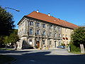
Part of the monastery complex
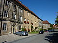
Street part

Filial church St. Michael, originally Sepulturkapelle


Attractions
In the list of architectural monuments in Lichtenfels (Upper Franconia) 22 monuments are identified for Klosterlangheim .
In the structural remainder of the baroque abbey there has been a local museum since 1982, which reminds of the history of the monastery and the place. It was founded and looked after by the Verein der Heimatfreunde Klosterlangheim.
See also
literature
- Johann Kaspar Bundschuh : Langheim . In: Geographical Statistical-Topographical Lexicon of Franconia . tape 3 : I-Ne . Verlag der Stettinische Buchhandlung, Ulm 1801, DNB 790364301 , OCLC 833753092 , Sp. 273-277 ( digitized version ).
- Günter Dippold: The monastery secularization of 1802/03. The example of Langheim . Bayreuth 2003, (local supplement to the Oberfränkisches Schulanzeiger 307).
- Ferdinand Geldner: Langheim. Work and fate of a Franconian Cistercian monastery . 2nd edition with an afterword by Günter Dippold, Lichtenfels 1990.
- Klosterlangheim. Symposium organized by the Hanns Seidel Foundation in cooperation with the Otto Friedrich University of Bamberg and the Bavarian State Office for Monument Preservation . Munich 1994 (workbook 65 of the Bavarian State Office for Monument Preservation).
- Pleikard Joseph Stumpf : Langheim . In: Bavaria: a geographical-statistical-historical handbook of the kingdom; for the Bavarian people . Second part. Munich 1853, p. 606-607 ( digitized version ).
Web links
- Klosterlangheim in the location database of the Bavarian State Library Online . Bavarian State Library
Individual evidence
- ↑ Klosterlangheim on the website of the city of Lichtenfels . Retrieved July 2, 2011
- ↑ Kgl. Statistical Bureau (ed.): Complete list of localities of the Kingdom of Bavaria. According to districts, administrative districts, court districts and municipalities, including parish, school and post office affiliation ... with an alphabetical general register containing the population according to the results of the census of December 1, 1875 . Adolf Ackermann, Munich 1877, 2nd section (population figures from 1871, cattle figures from 1873), Sp. 1077 , urn : nbn: de: bvb: 12-bsb00052489-4 ( digitized ).
- ^ Wilhelm Volkert (ed.): Handbook of Bavarian offices, communities and courts 1799–1980 . CH Beck, Munich 1983, ISBN 3-406-09669-7 , p. 511 .
- ^ Federal Statistical Office (ed.): Historical municipality directory for the Federal Republic of Germany. Name, border and key number changes in municipalities, counties and administrative districts from May 27, 1970 to December 31, 1982 . W. Kohlhammer GmbH, Stuttgart / Mainz 1983, ISBN 3-17-003263-1 , p. 694 .

Book at the forest | Degendorf | Eichig | Gnellenroth | Hammer | Isling | Klosterlangheim | Kösten | Köttel | Krappenroth | Lame | Mistletoe field | Mönchkröttendorf | Oberlangheim | Oberwallenstadt | Reundorf | Roth | Rothmannsthal | Schney | Schönsreuth | Seehof | Seubelsdorf | Stetten | Sticks | Tiefenroth | Shoot | Unterwallenstadt | Vineyard